

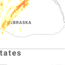
Hail Map for Monday, June 8, 2020

Number of Impacted Households on 6/8/2020
0
Impacted by 1" or Larger Hail
0
Impacted by 1.75" or Larger Hail
0
Impacted by 2.5" or Larger Hail
Square Miles of Populated Area Impacted on 6/8/2020
0
Impacted by 1" or Larger Hail
0
Impacted by 1.75" or Larger Hail
0
Impacted by 2.5" or Larger Hail


Cities Most Affected by Hail Storms of 6/8/2020
| Hail Size | Demographics of Zip Codes Affected | ||||||
|---|---|---|---|---|---|---|---|
| City | Count | Average | Largest | Pop Density | House Value | Income | Age |
| Bassett, NE | 4 | 2.38 | 4.25 | 1 | $41k | $25.5k | 50.4 |
| Wagner, SD | 2 | 2.25 | 2.50 | 5 | $56k | $23.6k | 34.9 |
| Atkinson, NE | 2 | 1.75 | 1.75 | 2 | $52k | $30.6k | 47.1 |
| North Platte, NE | 1 | 2.50 | 2.50 | 50 | $79k | $36.3k | 38.7 |
| Williams, MN | 1 | 2.00 | 2.00 | 5 | $58k | $32.6k | 47.8 |
| Lake Bronson, MN | 1 | 2.00 | 2.00 | 2 | $23k | $29.0k | 47.1 |
| Emerado, ND | 1 | 1.75 | 1.75 | 7 | $80k | $36.7k | 42.7 |
| Stuart, NE | 1 | 1.75 | 1.75 | 2 | $53k | $30.7k | 47.1 |
| Maxwell, NE | 1 | 1.75 | 1.75 | 1 | $52k | $32.3k | 41.6 |
| Wannaska, MN | 1 | 1.75 | 1.75 | 4 | $67k | $45.4k | 42.1 |
| Mitchell, SD | 1 | 1.75 | 1.75 | 72 | $73k | $33.2k | 37.8 |
| Newport, NE | 1 | 1.75 | 1.75 | 1 | $15k | $32.7k | 50.8 |
| Roosevelt, MN | 1 | 1.75 | 1.75 | 6 | $57k | $30.8k | 44.5 |
Hail and Wind Damage Spotted on 6/8/2020
Filter by Report Type:Hail ReportsWind Reports
North Dakota
| Local Time | Report Details |
|---|---|
| 3:02 PM CDT | Quarter sized hail reported near Grafton, ND, 65.2 miles ENE of Devils Lake, ND |
| 3:02 PM CDT | Quarter sized hail reported near Grafton, ND, 70.1 miles ENE of Devils Lake, ND |
| 3:30 PM CDT | Quarter sized hail reported near Park River, ND, 56.6 miles ENE of Devils Lake, ND |
| 5:13 PM CDT | Also quarter sized hai in grand forks county ND, 65.8 miles E of Devils Lake, ND |
| 5:15 PM CDT | Half Dollar sized hail reported near Arvilla, ND, 64.8 miles ESE of Devils Lake, ND |
| 5:24 PM CDT | Golf Ball sized hail reported near Emerado, ND, 66.6 miles E of Devils Lake, ND |
| 5:45 PM CDT | Quarter sized hail reported near Manvel, ND, 76.3 miles E of Devils Lake, ND, dime to quarter sized hail and 60 mph winds. |
| 1:52 AM CDT | Peak wind measured at an ndawn statio in richland county ND, 44.4 miles S of Fargo, ND |
| 2:08 AM CDT | Large tree limb blown down onto house and fence blown over. time estimated based on radar. report posted via social medi in richland county ND, 43.3 miles S of Fargo, ND |
Minnesota
| Local Time | Report Details |
|---|---|
| 4:01 PM CDT | Hen Egg sized hail reported near Lake Bronson, MN, 41.5 miles W of Roseau, MN, report and photo posted via social media. |
| 4:28 PM CDT | Report from mping: trees uprooted or snapped; roof blown of in kittson county MN, 54 miles WSW of Roseau, MN |
| 4:30 PM CDT | Half Dollar sized hail reported near Lancaster, MN, 32.4 miles WNW of Roseau, MN |
| 6:02 PM CDT | Quarter sized hail reported near East Grand Forks, MN, 75.5 miles SW of Roseau, MN, along with heavy rain. |
| 8:18 PM CDT | Half Dollar sized hail reported near Roseau, MN, 22.5 miles SE of Roseau, MN |
| 8:50 PM CDT | Golf Ball sized hail reported near Roosevelt, MN, 31.4 miles ESE of Roseau, MN, reported at norris camp. |
| 9:15 PM CDT | Hen Egg sized hail reported near Williams, MN, 43 miles E of Roseau, MN, report and photo posted via social media. time estimated based on radar. |
| 9:33 PM CDT | Golf Ball sized hail reported near Wannaska, MN, 17.6 miles S of Roseau, MN, mainly quarter sized weith a few golf balls mixed in. |
| 9:55 PM CDT | Quarter sized hail reported near Roseau, MN, 7.9 miles ESE of Roseau, MN, very heavy rain and quite a few large hail mixed in. |
| 12:38 AM CDT | Half Dollar sized hail reported near Vining, MN, 74 miles SE of Fargo, ND, quarter to half dollar sized hail in very heavy rain. |
| 2:32 AM CDT | Peak wind measured at fergus falls airport /kffm in otter tail county MN, 51.6 miles SE of Fargo, ND |
| 2:33 AM CDT | Peak wind measured at a personal weather statio in otter tail county MN, 53.9 miles SE of Fargo, ND |
| 2:37 AM CDT | Peak wind measured at an rwis station. local power outages reporte in wilkin county MN, 35.5 miles SE of Fargo, ND |
| 2:42 AM CDT | Peak winds at the prairie wetlands center weaher statio in otter tail county MN, 56.4 miles SE of Fargo, ND |
| 2:45 AM CDT | Small branches down in estimated 60 mph winds. hail of a half an inch. heavy rai in otter tail county MN, 53.6 miles SE of Fargo, ND |
Nebraska
| Local Time | Report Details |
|---|---|
| 6:31 PM CDT | Quarter sized hail reported near Anselmo, NE, 42.7 miles NE of North Platte, NE, report from mping: quarter (1.00 in.). |
| 6:34 PM CDT | Half Dollar sized hail reported near Arnold, NE, 38.1 miles NE of North Platte, NE |
| 6:35 PM CDT | Ping Pong Ball sized hail reported near Arnold, NE, 37.3 miles NE of North Platte, NE, report from mping: ping pong ball (1.50 in.). |
| 6:36 PM CDT | Half Dollar sized hail reported near Arnold, NE, 37.7 miles NE of North Platte, NE, report from mping: half dollar (1.25 in.). |
| 6:55 PM CDT | Golf Ball sized hail reported near Maxwell, NE, 12.8 miles ESE of North Platte, NE |
| 6:55 PM CDT | Quarter sized hail reported near Bassett, NE, 44.8 miles W of Oneill, NE |
| 6:55 PM CDT | Storm damage reported in blaine county NE, 71.7 miles WSW of Oneill, NE |
| 7:07 PM CDT | Quarter sized hail reported near Anselmo, NE, 47.4 miles NE of North Platte, NE |
| 7:25 PM CDT | Quarter sized hail reported near Thedford, NE, 59.1 miles N of North Platte, NE |
| 7:26 PM CDT | Quarter sized hail reported near Thedford, NE, 59.1 miles N of North Platte, NE, delayed report recieved via social media. |
| 7:55 PM CDT | Grapefruit sized hail reported near Bassett, NE, 32 miles WSW of Oneill, NE |
| 8:00 PM CDT | Golf Ball sized hail reported near Bassett, NE, 33 miles W of Oneill, NE, report via social media |
| 8:05 PM CDT | Golf Ball sized hail reported near Newport, NE, 31 miles W of Oneill, NE, report via social media |
| 8:15 PM CDT | Tennis Ball sized hail reported near North Platte, NE, 8.2 miles ENE of North Platte, NE, mostly quarter sized hail... but reached tennis ball size. |
| 8:20 PM CDT | Golf Ball sized hail reported near Atkinson, NE, 20.6 miles W of Oneill, NE |
| 8:32 PM CDT | Golf Ball sized hail reported near Stuart, NE, 22.4 miles WNW of Oneill, NE, report from mping: golf ball (1.75 in.). |
| 8:34 PM CDT | Quarter sized hail reported near Atkinson, NE, 19.2 miles W of Oneill, NE |
| 8:45 PM CDT | Ping Pong Ball sized hail reported near Stapleton, NE, 27.1 miles NE of North Platte, NE |
| 8:45 PM CDT | Ping Pong Ball sized hail reported near Bassett, NE, 54.1 miles WSW of Oneill, NE |
| 8:52 PM CDT | Golf Ball sized hail reported near Bassett, NE, 47.8 miles WSW of Oneill, NE |
| 9:05 PM CDT | Storm damage reported in holt county NE, 24.3 miles NNW of Oneill, NE |
| 9:06 PM CDT | Golf Ball sized hail reported near Bassett, NE, 47.8 miles WSW of Oneill, NE |
| 9:53 PM CDT | Golf Ball sized hail reported near Atkinson, NE, 18.6 miles WNW of Oneill, NE |
| 9:15 PM MDT | Sidney airport asos measured wind gust of 67mp in cheyenne county NE, 63.4 miles SE of Scottsbluff, NE |
| 9:25 PM MDT | Sidney airport asos measured wind gust 61mp in cheyenne county NE, 63.4 miles SE of Scottsbluff, NE |
| 9:31 PM MDT | Marble size hail in addition to estimated 60mph wind gus in cheyenne county NE, 48.5 miles SE of Scottsbluff, NE |
| 9:48 PM MDT | Report of multiple healthy trees uprooted across town. time estimated from rada in garden county NE, 59.5 miles ESE of Scottsbluff, NE |
Colorado
| Local Time | Report Details |
|---|---|
| 7:42 PM MDT | Mesonet station co043 014w176 briggsdal in weld county CO, 71.3 miles NNE of Denver, CO |
| 8:08 PM MDT | Awos station k1ow oscar madi in weld county CO, 70 miles SSW of Scottsbluff, NE |
| 9:10 PM MDT | Quarter sized hail reported near Timnath, CO, 54.5 miles N of Denver, CO |
| 10:30 PM MDT | Power lines down in merino per sterling dispatch in logan county CO, 41.9 miles NW of Yuma, CO |
| 10:50 PM MDT | Quarter sized hail reported near Sterling, CO, 43.7 miles NW of Yuma, CO |
| 11:30 PM MDT | Awos station kstk sterlin in logan county CO, 45.1 miles NW of Yuma, CO |
| 11:52 PM MDT | Mesonet station co048 385s271 holyok in phillips county CO, 33 miles NE of Yuma, CO |
| 12:10 AM MDT | Mesonet station ew7755 akro in washington county CO, 25.4 miles W of Yuma, CO |
| 12:10 AM MDT | Kako peak gust 83 mp in washington county CO, 26 miles W of Yuma, CO |
| 12:14 AM MDT | Numerous reports of significant damage in akron east to otis due to a micro/macroburst. 40-50 power poles down (fell to the northeast)... carports removed from houses in washington county CO, 26.9 miles W of Yuma, CO |
| 12:15 AM MDT | Carport attached to the house was removed. also had accumulating sub-severe hai in washington county CO, 25.9 miles W of Yuma, CO |
| 12:15 AM MDT | Multiple reports of damage in and near otis. numerous power poles down. several outbuildings destroye in washington county CO, 13.4 miles WNW of Yuma, CO |
| 12:37 AM MDT | Power poles down near the intersection of highway 59 and yuma county road 54. time estimate in yuma county CO, 16.7 miles N of Yuma, CO |
| 1:01 AM MDT | Tractor trailer blown over and numerous large tree limbs down across flemin in logan county CO, 39.2 miles N of Yuma, CO |
South Dakota
| Local Time | Report Details |
|---|---|
| 9:43 PM CDT | Quarter sized hail reported near Wagner, SD, 40.4 miles NNE of Oneill, NE |
| 9:52 PM CDT | Hen Egg sized hail reported near Wagner, SD, 46.5 miles NNE of Oneill, NE |
| 9:58 PM CDT | Tennis Ball sized hail reported near Wagner, SD, 43.8 miles NNE of Oneill, NE |
| 10:00 PM CDT | Golf Ball sized hail reported near Mitchell, SD, 66.4 miles W of Sioux Falls, SD |
| 11:04 PM CDT | Quarter sized hail reported near Fedora, SD, 61.9 miles WNW of Sioux Falls, SD, time estimated from radar. |
| 5:39 AM CDT | Storm damage reported in aurora county SD, 86.7 miles N of Oneill, NE |
| 6:08 AM CDT | Report from mping: 3-inch tree limbs broken; power poles broke in davison county SD, 66.6 miles W of Sioux Falls, SD |
| 6:10 AM CDT | Tree branches down... pickup topper laying in the stree in davison county SD, 66.6 miles W of Sioux Falls, SD |
Connect with Interactive Hail Maps