

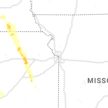
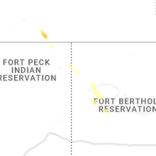
Hail Map for Thursday, June 9, 2022

Number of Impacted Households on 6/9/2022
0
Impacted by 1" or Larger Hail
0
Impacted by 1.75" or Larger Hail
0
Impacted by 2.5" or Larger Hail
Square Miles of Populated Area Impacted on 6/9/2022
0
Impacted by 1" or Larger Hail
0
Impacted by 1.75" or Larger Hail
0
Impacted by 2.5" or Larger Hail


Cities Most Affected by Hail Storms of 6/9/2022
| Hail Size | Demographics of Zip Codes Affected | ||||||
|---|---|---|---|---|---|---|---|
| City | Count | Average | Largest | Pop Density | House Value | Income | Age |
| Lenora, KS | 2 | 1.75 | 1.75 | 1 | $30k | $31.7k | 50.0 |
| North Platte, NE | 1 | 2.50 | 2.50 | 50 | $79k | $36.3k | 38.7 |
| Wellfleet, NE | 1 | 2.50 | 2.50 | 1 | $85k | $37.1k | 45.3 |
| Maxwell, NE | 1 | 1.75 | 1.75 | 1 | $52k | $32.3k | 41.6 |
| Holbrook, NE | 1 | 1.75 | 1.75 | 2 | $20k | $25.9k | 45.4 |
| Indianola, NE | 1 | 1.75 | 1.75 | 2 | $42k | $31.1k | 45.6 |
Hail and Wind Damage Spotted on 6/9/2022
Filter by Report Type:Hail ReportsWind Reports
States Impacted
New Jersey, Kansas, Florida, North Carolina, South Carolina, Georgia, Louisiana, South Dakota, Colorado, Maryland, Nebraska, Texas, OklahomaNew Jersey
| Local Time | Report Details |
|---|---|
| 9:50 AM EDT | Numerous trees down on cars and houses on deer park circle. pictures provided via social medi in camden county NJ, 82.7 miles SW of Brooklyn, NY |
Kansas
| Local Time | Report Details |
|---|---|
| 12:58 PM CDT | Golf Ball sized hail reported near Lenora, KS, 57.7 miles ENE of Colby, KS, norton county sheriff dispatch reported that a spotter had golf ball hail in the lenora area. |
| 3:45 PM CDT | Quarter sized hail reported near Clearwater, KS, 12.5 miles SW of Wichita, KS, dime to quarter size hail. |
| 3:48 PM CDT | Quarter sized hail reported near Clearwater, KS, 12.5 miles SW of Wichita, KS, dime to quarter size hail. |
| 12:58 AM CDT | Golf Ball sized hail reported near Lenora, KS, 57.7 miles ENE of Colby, KS, corrects previous hail report from lenora. norton county sheriff dispatch reported that a spotter had golf ball hail in the lenora area. |
| 2:27 AM CDT | Delayed report. picture on social media of a large tree knocked down in andale. time estimated by rada in sedgwick county KS, 17.6 miles WNW of Wichita, KS |
| 2:35 AM CDT | Storm damage reported in sedgwick county KS, 7.2 miles WNW of Wichita, KS |
| 2:43 AM CDT | Asos station kict wichita eisenhower airpor in sedgwick county KS, 5.8 miles WSW of Wichita, KS |
| 2:50 AM CDT | Delayed report. picture of large tree branch snapped off tree. time estimated by rada in sedgwick county KS, 4.7 miles S of Wichita, KS |
| 2:52 AM CDT | Viola... ks mesonet sit in sumner county KS, 22.5 miles SW of Wichita, KS |
| 2:58 AM CDT | Awos station kiab mcconnell af in sedgwick county KS, 5.9 miles SE of Wichita, KS |
| 4:11 AM CDT | 1 to 2 inch tree limbs downed. relayed by ksn in coffey county KS, 55.5 miles NNW of Chanute, KS |
Florida
| Local Time | Report Details |
|---|---|
| 1:08 PM CDT | Trees down and many power outages northeast of ponce de leon. time estimated from rada in holmes county FL, 40 miles NE of Miramar Beach, FL |
| 1:23 PM CDT | Trees down south of bonifay. time estimated from rada in holmes county FL, 47 miles NE of Miramar Beach, FL |
| 1:30 PM CDT | 911 center reported 1 tree down along hwy 273. two powerlines were also down in the count in washington county FL, 57.2 miles ENE of Miramar Beach, FL |
| 3:45 PM EDT | St. lucie emergency management reported at least four homes with wind damage in spanish lakes golf village by 187 west caribbean boulevard... port st. lucie. radar esti in st. lucie county FL, 4.6 miles ENE of Port Saint Lucie, FL |
| 4:30 PM EDT | Mesonet station xjak jacksonvill in duval county FL, 11.3 miles ENE of Jacksonville, FL |
North Carolina
| Local Time | Report Details |
|---|---|
| 2:15 PM EDT | Trees down near intersection of lawyers rd and chestnut lake dr in mint hil in mecklenburg county NC, 7.4 miles ESE of Charlotte, NC |
South Carolina
| Local Time | Report Details |
|---|---|
| 2:37 PM EDT | Jasper county dispatch reported a tree down near the intersection of tillman road and tarboro roa in jasper county SC, 27.2 miles N of Savannah, GA |
| 3:04 PM EDT | Burton fire department shared pictures on twitter of 4 large trees down on mink point boulevard. the road is currently close in beaufort county SC, 31.4 miles NE of Savannah, GA |
| 3:04 PM EDT | Burton fire department reported a tree down on a home on falls road. the large tree damaged a propane tank which was leakin in beaufort county SC, 30.1 miles NE of Savannah, GA |
| 3:05 PM EDT | Beaufort county dispatch reported a tree down on power lines near the intersection of salem road and salem drive eas in beaufort county SC, 32.8 miles NE of Savannah, GA |
| 3:05 PM EDT | Beaufort county dispatch reported a tree down on stone marten circl in beaufort county SC, 31.4 miles NE of Savannah, GA |
| 3:09 PM EDT | Beaufort county dispatch reported a tree down on ribaut road near the intersection with north stree in beaufort county SC, 33.6 miles NE of Savannah, GA |
| 3:09 PM EDT | Beaufort county dispatch reported a tree down near the intersection of marsh road and duke stree in beaufort county SC, 34.1 miles NE of Savannah, GA |
| 3:09 PM EDT | Beaufort county dispatch reported a tree down on thomas sumter street and sams point roa in beaufort county SC, 36.7 miles NE of Savannah, GA |
| 3:10 PM EDT | Beaufort county dispatch reported a tree down on southern magnolia drive near the intersection with sams point roa in beaufort county SC, 36.7 miles NE of Savannah, GA |
| 3:12 PM EDT | Beaufort county dispatch reported a tree down on a house with power lines down causing a structure fire in the 20 block of gay driv in beaufort county SC, 34.4 miles NE of Savannah, GA |
| 3:19 PM EDT | Beaufort county dispatch reported a tree down on doctor martin luther king junior drive near penn center roa in beaufort county SC, 36.7 miles NE of Savannah, GA |
| 3:20 PM EDT | Beaufort county dispatch reported a tree down on ball park road near the intersection with saxonville roa in beaufort county SC, 37.7 miles NE of Savannah, GA |
| 3:43 PM EDT | Beaufort county dispatch reported a tree down on okatie highway near the intersection with bluffton parkwa in beaufort county SC, 15.1 miles NNE of Savannah, GA |
| 6:56 PM EDT | Public reported damage to a small outdoor shed structure which collapsed onto a fence. there was also reported damage to a vehicle with the top of a pump house blown of in horry county SC, 65.3 miles NE of Charleston, SC |
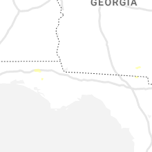
Georgia
| Local Time | Report Details |
|---|---|
| 4:13 PM EDT | Chatham county emergency management agency reported trees down near the intersection of braxton manor drive and meinhard roa in chatham county GA, 10.2 miles NW of Savannah, GA |
| 4:27 PM EDT | Chatham county emergency management agency reported a tree down on smith avenue near main stree in chatham county GA, 4.4 miles NW of Savannah, GA |
| 4:42 PM EDT | Chatham county emergency management agency reported a tree down in the 600 block of main street. the road was blocked due to the tree falling on power line in chatham county GA, 3.2 miles WNW of Savannah, GA |
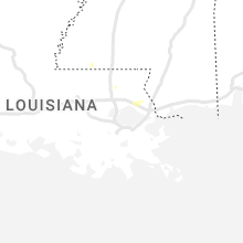
Louisiana
| Local Time | Report Details |
|---|---|
| 5:03 PM CDT | Quarter sized hail reported near Mandeville, LA, 29.5 miles N of New Orleans, LA, reported at mandeville middle school. |
| 5:05 PM CDT | Half Dollar sized hail reported near Mandeville, LA, 28.7 miles N of New Orleans, LA, quarter to half-dollar size hail reported on social media. |
| 9:20 PM CDT | Roof damage to guard shack in gabriel subdivision in 800 block of yenni blvd. power outage in area affecting approximately 2000 customers. fence damage off palmetto dri in jefferson county LA, 10.5 miles W of New Orleans, LA |
South Dakota
| Local Time | Report Details |
|---|---|
| 4:05 PM MDT | 50-60 mph winds in butte county SD, 50.8 miles NNW of Rapid City, SD |
| 4:20 PM MDT | Large branch broken off tree. estimate 60 mph wind in butte county SD, 41.7 miles NNW of Rapid City, SD |
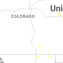
Colorado
| Local Time | Report Details |
|---|---|
| 4:34 PM MDT | Half Dollar sized hail reported near Atwood, CO, 41.8 miles NW of Yuma, CO, report via twitter. time estimated based on radar. |
Maryland
| Local Time | Report Details |
|---|---|
| 7:51 PM EDT | Large tree limb pierced through the roof of a home in the 6500 block of fruitgift place. multiple trees down in the vicinity as wel in howard county MD, 14.6 miles WSW of Baltimore, MD |
Nebraska
| Local Time | Report Details |
|---|---|
| 7:30 PM CDT | Quarter sized hail reported near Dickens, NE, 12.7 miles WSW of North Platte, NE |
| 7:45 PM CDT | Golf Ball sized hail reported near Maxwell, NE, 18.2 miles NE of North Platte, NE |
| 8:00 PM CDT | Tennis Ball sized hail reported near North Platte, NE, 19.9 miles SSW of North Platte, NE |
| 8:10 PM CDT | Tennis Ball sized hail reported near Wellfleet, NE, 29.9 miles S of North Platte, NE |
| 8:17 PM CDT | Half Dollar sized hail reported near Callaway, NE, 37.5 miles ENE of North Platte, NE |
| 8:21 PM CDT | Ping Pong Ball sized hail reported near Maywood, NE, 30.9 miles S of North Platte, NE |
| 8:38 PM CDT | Quarter sized hail reported near Callaway, NE, 51.3 miles ENE of North Platte, NE |
| 8:51 PM CDT | Ping Pong Ball sized hail reported near Mc Cook, NE, 46.4 miles S of North Platte, NE, report via social media. |
| 9:00 PM CDT | Golf Ball sized hail reported near Indianola, NE, 65.1 miles SSE of North Platte, NE |
| 9:15 PM CDT | Quarter sized hail reported near Mc Cook, NE, 47.4 miles S of North Platte, NE |
| 9:28 PM CDT | Quarter sized hail reported near Indianola, NE, 65.1 miles SSE of North Platte, NE |
| 11:32 PM CDT | Golf Ball sized hail reported near Holbrook, NE, 69.4 miles SE of North Platte, NE, facebook. |
Texas
| Local Time | Report Details |
|---|---|
| 7:37 PM CDT | West texas mesonet. severe gusts lasted 4 minute in moore county TX, 43.2 miles N of Amarillo, TX |
| 7:44 PM CDT | Quarter sized hail reported near Channing, TX, 43 miles NW of Amarillo, TX |
| 8:08 PM CDT | West texas mesone in hutchinson county TX, 49.3 miles NNE of Amarillo, TX |
| 8:20 PM CDT | Asos station kbgd borger (asos in hutchinson county TX, 41.9 miles NE of Amarillo, TX |
| 8:38 PM CDT | Asos station kbgd borger (asos in hutchinson county TX, 41.9 miles NE of Amarillo, TX |
| 8:44 PM CDT | West texas mesone in oldham county TX, 29.3 miles W of Amarillo, TX |
| 9:14 PM CDT | West texas mesonet. initial severe gust at 914 pm cdt with peak at 919 pm cd in gray county TX, 56 miles ENE of Amarillo, TX |
| 10:15 PM CDT | Both the 2215 and 2220 cdt 5 minute obs gusted to 51 kts. asos station kbgd borger (asos in hutchinson county TX, 41.9 miles NE of Amarillo, TX |
| 10:40 PM CDT | Storm damage reported in gray county TX, 59.5 miles NNW of Childress, TX |
| 10:40 PM CDT | Storm damage reported in randall county TX, 20.5 miles SW of Amarillo, TX |
| 10:45 PM CDT | West texas mesonet in hall county TX, 37.4 miles WNW of Childress, TX |
| 10:55 PM CDT | West texas mesonet 2wsw turke in hall county TX, 41.2 miles W of Childress, TX |
| 11:03 PM CDT | West texas mesonet memphis 1n in hall county TX, 27.6 miles NW of Childress, TX |
| 11:22 PM CDT | First gust was 2322 cdt with 66 mph. peak gust of 67 mph was at 2327 cdt. last gust of 58 mph was at 2329 cd in collingsworth county TX, 25.1 miles N of Childress, TX |
| 11:39 PM CDT | West texas mesonet 2nne childres in childress county TX, 2.2 miles NNE of Childress, TX |
| 12:30 AM CDT | Storm damage reported in wilbarger county TX, 49.4 miles E of Childress, TX |
| 12:50 AM CDT | West texas mesonet olton 6 in lamb county TX, 37.5 miles NNW of Lubbock, TX |
| 12:51 AM CDT | West texas mesonet olton 6 in lamb county TX, 37.5 miles NNW of Lubbock, TX |
| 12:55 AM CDT | Storm damage reported in wilbarger county TX, 49.8 miles WNW of Wichita Falls, TX |
| 1:25 AM CDT | Storm damage reported in wichita county TX, 2.9 miles NNE of Wichita Falls, TX |
| 1:26 AM CDT | Storm damage reported in archer county TX, 19.3 miles WSW of Wichita Falls, TX |
| 1:32 AM CDT | Storm damage reported in wichita county TX, 2.6 miles WSW of Wichita Falls, TX |
| 1:34 AM CDT | Storm damage reported in wichita county TX, 5.6 miles SW of Wichita Falls, TX |
| 1:35 AM CDT | Storm damage reported in wichita county TX, 4.3 miles N of Wichita Falls, TX |
| 1:45 AM CDT | Storm damage reported in childress county TX, 3.9 miles W of Childress, TX |
Oklahoma
| Local Time | Report Details |
|---|---|
| 11:45 PM CDT | Storm damage reported in harmon county OK, 27.3 miles NE of Childress, TX |
| 12:15 AM CDT | Storm damage reported in jackson county OK, 51.6 miles ENE of Childress, TX |
| 12:30 AM CDT | Storm damage reported in tillman county OK, 52.3 miles NW of Wichita Falls, TX |
| 1:05 AM CDT | Storm damage reported in tillman county OK, 24.7 miles NNW of Wichita Falls, TX |
| 1:15 AM CDT | Likely heat burs in washita county OK, 73.2 miles SSE of Woodward, OK |
| 3:55 AM CDT | Storm damage reported in kay county OK, 64.6 miles S of Wichita, KS |
| 3:55 AM CDT | Storm damage reported in kay county OK, 64.8 miles S of Wichita, KS |
| 3:58 AM CDT | Storm damage reported in kay county OK, 67.8 miles S of Wichita, KS |
| 4:08 AM CDT | Storm damage reported in kay county OK, 67.8 miles S of Wichita, KS |
| 4:25 AM CDT | Storm damage reported in noble county OK, 65.3 miles WNW of Tulsa, OK |
| 4:30 AM CDT | Trees downed... winds estimated 60-65 mph. time estimated from rada in noble county OK, 58.5 miles NNE of Oklahoma City, OK |
| 4:39 AM CDT | Storm damage reported in payne county OK, 52.4 miles NNE of Oklahoma City, OK |
| 4:50 AM CDT | Heat burs in grady county OK, 38.8 miles SW of Oklahoma City, OK |
| 5:15 AM CDT | Storm damage reported in lincoln county OK, 42.4 miles ENE of Oklahoma City, OK |
| 5:15 AM CDT | Storm damage reported in lincoln county OK, 42.5 miles ENE of Oklahoma City, OK |
| 5:20 AM CDT | Storm damage reported in lincoln county OK, 42.4 miles ENE of Oklahoma City, OK |
| 6:10 AM CDT | Storm damage reported in pontotoc county OK, 41.2 miles NW of Atoka, OK |
Connect with Interactive Hail Maps