

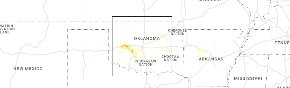
Hail Map for Wednesday, June 8, 2022
Number of Impacted Households on 6/8/2022
0
Impacted by 1" or Larger Hail
0
Impacted by 1.75" or Larger Hail
0
Impacted by 2.5" or Larger Hail
Square Miles of Populated Area Impacted on 6/8/2022
0
Impacted by 1" or Larger Hail
0
Impacted by 1.75" or Larger Hail
0
Impacted by 2.5" or Larger Hail


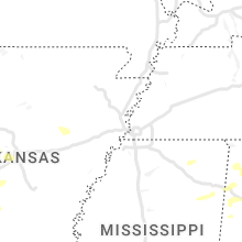


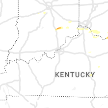


Cities Most Affected by Hail Storms of 6/8/2022
| Hail Size | Demographics of Zip Codes Affected | ||||||
|---|---|---|---|---|---|---|---|
| City | Count | Average | Largest | Pop Density | House Value | Income | Age |
| Charleston, WV | 3 | 1.75 | 1.75 | 226 | $71k | $29.9k | 42.1 |
| Rush Springs, OK | 2 | 2.13 | 2.50 | 10 | $43k | $25.3k | 40.9 |
| North Vernon, IN | 2 | 1.75 | 1.75 | 109 | $81k | $39.1k | 37.6 |
| Crown City, OH | 2 | 1.75 | 1.75 | 47 | $74k | $26.2k | 39.4 |
| Morgantown, WV | 1 | 2.00 | 2.00 | 282 | $109k | $39.8k | 36.5 |
| Masontown, WV | 1 | 2.00 | 2.00 | 40 | $60k | $24.5k | 42.1 |
| Masontown, PA | 1 | 2.00 | 2.00 | 402 | $56k | $24.3k | 41.8 |
| Anadarko, OK | 1 | 1.75 | 1.75 | 56 | $43k | $26.8k | 33.9 |
| Manchester, OH | 1 | 1.75 | 1.75 | 63 | $62k | $28.7k | 40.9 |
| Clinton, OK | 1 | 1.75 | 1.75 | 77 | $56k | $27.1k | 35.4 |
| Woodsfield, OH | 1 | 1.75 | 1.75 | 50 | $59k | $30.7k | 45.5 |
| Norman, OK | 1 | 1.75 | 1.75 | 767 | $124k | $46.7k | 28.5 |
Hail and Wind Damage Spotted on 6/8/2022
Filter by Report Type:Hail ReportsWind Reports
States Impacted
Alabama, Oklahoma, Texas, Arkansas, North Carolina, South Carolina, Indiana, Virginia, Ohio, Kentucky, Mississippi, West Virginia, Florida, New Mexico, Maryland, PennsylvaniaAlabama
| Local Time | Report Details |
|---|---|
| 7:00 AM CDT | Trees reported down blocking the roadway at the 3000 block of county rd 42 west of jemiso in chilton county AL, 38.6 miles S of Birmingham, AL |
| 10:36 PM UTC | Trees were blown down near shottsvill in marion county AL, 48.1 miles SW of Florence, AL |
| 10:40 PM UTC | Multiple trees reported down in russellvill in franklin county AL, 20.3 miles S of Florence, AL |
| 11:00 PM UTC | Trees were blown down on highway 172 near hacklebur in marion county AL, 36.9 miles SSW of Florence, AL |
| 6:05 PM CDT | Tree down at this locatio in morgan county AL, 40 miles ESE of Florence, AL |
| 11:05 PM UTC | Trees down throughout the phil campbell community... including three trees down on houses. time estimated by rada in franklin county AL, 31.1 miles S of Florence, AL |
| 11:18 PM UTC | Large tree down on a home and vehicl in winston county AL, 39.5 miles S of Florence, AL |
| 6:19 PM CDT | Tree down at wall triana and nick davi in madison county AL, 52.6 miles E of Florence, AL |
| 12:15 AM UTC | Several trees were blown down along us 231 around clevelan in blount county AL, 35.6 miles NNE of Birmingham, AL |
| 12:30 AM UTC | A few trees were blown down around graysville. one was blocking highway 78 and one down on cherry av in jefferson county AL, 11.9 miles NW of Birmingham, AL |
| 8:00 PM CDT | Trees down at the corner of cr 50 and cr 44. tim estimated from rada in dekalb county AL, 53.1 miles SW of Chattanooga, TN |
| 1:15 AM UTC | Several trees were blown down around ohatche in calhoun county AL, 48.5 miles ENE of Birmingham, AL |
Oklahoma
| Local Time | Report Details |
|---|---|
| 7:04 AM CDT | Golf Ball sized hail reported near Clinton, OK, 69.3 miles SSE of Woodward, OK |
| 7:04 AM CDT | Storm damage reported in custer county OK, 69.3 miles SSE of Woodward, OK |
| 7:10 AM CDT | Storm damage reported in washita county OK, 73.2 miles SSE of Woodward, OK |
| 7:15 AM CDT | Storm damage reported in custer county OK, 70.5 miles W of Oklahoma City, OK |
| 7:29 AM CDT | Quarter sized hail reported near Weatherford, OK, 66.6 miles W of Oklahoma City, OK |
| 7:29 AM CDT | Quarter sized hail reported near Weatherford, OK, 68.3 miles W of Oklahoma City, OK, report from mping: quarter (1.00 in.). |
| 7:50 AM CDT | Wind driven hail damage to house. this includes siding... shingles and fenc in caddo county OK, 59.2 miles W of Oklahoma City, OK |
| 7:59 AM CDT | Broadcast media relayed chaser report of measured thunderstorm wind gust of 59 mph and nickel hail between prue and osag in osage county OK, 21.1 miles WNW of Tulsa, OK |
| 8:00 AM CDT | Storm damage reported in caddo county OK, 58 miles WSW of Oklahoma City, OK |
| 8:00 AM CDT | Storm damage reported in caddo county OK, 57.5 miles WSW of Oklahoma City, OK |
| 8:15 AM CDT | Storm damage reported in harmon county OK, 27.3 miles NE of Childress, TX |
| 8:20 AM CDT | Quarter sized hail reported near Rush Springs, OK, 53.8 miles SSW of Oklahoma City, OK, social media report of 1 hail in rush springs. |
| 8:20 AM CDT | Golf Ball sized hail reported near Anadarko, OK, 48.1 miles WSW of Oklahoma City, OK, golf ball sized hail reported just north of anadarko. |
| 8:21 AM CDT | Golf Ball sized hail reported near Rush Springs, OK, 54.1 miles SSW of Oklahoma City, OK, social media report of golf ball sized hail just west of rush springs. |
| 8:30 AM CDT | Storm damage reported in jackson county OK, 51.6 miles ENE of Childress, TX |
| 8:30 AM CDT | Tennis Ball sized hail reported near Rush Springs, OK, 54.9 miles SSW of Oklahoma City, OK |
| 8:47 AM CDT | Quarter sized hail reported near Norman, OK, 16.2 miles S of Oklahoma City, OK, report from mping: quarter (1.00 in.). |
| 8:47 AM CDT | Ping Pong Ball sized hail reported near Norman, OK, 16.1 miles S of Oklahoma City, OK, report from mping: ping pong ball (1.50 in.). |
| 8:48 AM CDT | Half Dollar sized hail reported near Norman, OK, 16.2 miles S of Oklahoma City, OK, report from mping: half dollar (1.25 in.). |
| 8:50 AM CDT | Storm damage reported in tillman county OK, 51.8 miles NW of Wichita Falls, TX |
| 8:50 AM CDT | Meassured 58 mph wind gus in grady county OK, 37 miles SW of Oklahoma City, OK |
| 8:50 AM CDT | Storm damage reported in grady county OK, 37 miles SW of Oklahoma City, OK |
| 8:52 AM CDT | Golf Ball sized hail reported near Norman, OK, 14.7 miles S of Oklahoma City, OK, off duty nws employee reports golf ball sized hail in nw norman. |
| 8:55 AM CDT | Storm damage reported in grady county OK, 38 miles SW of Oklahoma City, OK |
| 8:57 AM CDT | Report from mping: 3-inch tree limbs broken; power poles broke in grady county OK, 36.8 miles SW of Oklahoma City, OK |
| 8:59 AM CDT | Rfd winds in cold portion of storm after 12 degree of temperature chang in tulsa county OK, 12.9 miles SE of Tulsa, OK |
| 8:59 AM CDT | Report from mping: trees uprooted or snapped; roof blown of in grady county OK, 36.8 miles SW of Oklahoma City, OK |
| 9:13 AM CDT | Report from mping: 1-inch tree limbs broken; shingles blown of in grady county OK, 21.1 miles SW of Oklahoma City, OK |
| 9:19 AM CDT | Ping Pong Ball sized hail reported near Fletcher, OK, 61 miles SW of Oklahoma City, OK, social media report of ping pong ball sized hail just northeast of sterling. |
| 9:32 AM CDT | Spotter measured 63 mph thunderstorm wind gust ese of hulbert. multiple tree limbs... 1 to 2 inches in diameter damaged or broke in cherokee county OK, 51.9 miles ESE of Tulsa, OK |
| 9:35 AM CDT | Storm damage reported in cotton county OK, 32.4 miles NNE of Wichita Falls, TX |
| 10:45 AM CDT | Storm damage reported in hughes county OK, 48.8 miles NNW of Atoka, OK |
| 3:45 PM UTC | Large tree limbs down; time estimated by rada in sequoyah county OK, 32 miles WNW of Fort Smith, AR |
| 11:27 AM CDT | Emergency manager reported a couple of power poles downed by thunderstorm winds on oakwood roa in mayes county OK, 37.8 miles ENE of Tulsa, OK |
| 11:41 AM CDT | Report of power lines and trees down in locust grov in mayes county OK, 46.2 miles E of Tulsa, OK |
Texas
| Local Time | Report Details |
|---|---|
| 7:06 AM CDT | West texas mesonet site pantex 1 ese. site gusted to 58 mph or greater from 646 to 714 am cdt. other pantex maintained sites gusted to 65 to 75 mph during this perio in carson county TX, 17.8 miles ENE of Amarillo, TX |
| 7:14 AM CDT | West texas mesonet station claude 12sw. gust to 58 mph or greater occurred from 714 to 716 am cd in armstrong county TX, 24.6 miles SE of Amarillo, TX |
| 7:16 AM CDT | West texas mesonet station lake mcclellan 2nw. gusts to 58 mph or greater occurred from 713 to 716 am cd in gray county TX, 52.9 miles E of Amarillo, TX |
| 7:20 AM CDT | West texas mesonet station goodnight. a 58 mph gust recurred at 737 am cd in armstrong county TX, 38.5 miles ESE of Amarillo, TX |
| 7:31 AM CDT | West texas mesonet. a gust to 60 mph also occurred at 7:33 a in swisher county TX, 32.2 miles S of Amarillo, TX |
| 7:41 AM CDT | West texas mesonet station palo duro 4e (ja ranch). 58 mph or greater gusts occurred at times between 734 and 743 am cd in armstrong county TX, 48.5 miles ESE of Amarillo, TX |
| 7:58 AM CDT | Lesley west texas mesonet repor in hall county TX, 37.4 miles WNW of Childress, TX |
| 8:01 AM CDT | West texas mesonet. wind gusts of 58 to 66 mph occurred between 7:59 am and 8:02 a in briscoe county TX, 55.9 miles W of Childress, TX |
| 8:05 AM CDT | Measured by the west texas mesone in briscoe county TX, 49.1 miles W of Childress, TX |
| 8:07 AM CDT | West texas mesonet site wellington 6se. a 58 mph gust recurred at 755 am cd in collingsworth county TX, 25.1 miles N of Childress, TX |
| 8:10 AM CDT | West texas mesone in hall county TX, 41.2 miles W of Childress, TX |
| 8:10 AM CDT | West texas mesone in childress county TX, 1.8 miles NW of Childress, TX |
| 8:11 AM CDT | Childress municipal airpor in childress county TX, 4 miles W of Childress, TX |
| 8:12 AM CDT | Peak gust measured by the turkey west texas mesonet. wind gusts of 58 to 82 mph occurred from 8:10 am to 8:16 am... with another severe gust at 8:20 a in hall county TX, 41.2 miles W of Childress, TX |
| 8:15 AM CDT | West texas mesonet. wind gusts of 59 to 62 mph from 8:14 to 8:16 a in floyd county TX, 56.3 miles NE of Lubbock, TX |
| 8:18 AM CDT | West texas mesone in hall county TX, 28.1 miles NW of Childress, TX |
| 8:22 AM CDT | West texas mesone in hale county TX, 40.5 miles NNE of Lubbock, TX |
| 8:40 AM CDT | West texas mesonet. wind gusts of 58 to 62 mph occurred between 8:32 am and 8:40 a in floyd county TX, 42.2 miles NE of Lubbock, TX |
| 8:44 AM CDT | West texas mesonet. wind gusts of 65 to 81 mph from 8:43 to 8:45 a in motley county TX, 50.2 miles SW of Childress, TX |
| 8:50 AM CDT | Measured by the mcadoo west texas mesone in crosby county TX, 47.3 miles ENE of Lubbock, TX |
| 8:54 AM CDT | Mcadoo west texas mesonet. severe gusts started at 8:50 am and were continuing through 8:55 am (latest report in crosby county TX, 47.3 miles ENE of Lubbock, TX |
| 8:58 AM CDT | 59 mph at 8:58 cdt and 8:59 cd in cottle county TX, 36.7 miles S of Childress, TX |
| 9:00 AM CDT | West texas mesone in crosby county TX, 28.5 miles E of Lubbock, TX |
| 9:02 AM CDT | Storm damage reported in hockley county TX, 22 miles WNW of Lubbock, TX |
| 9:03 AM CDT | West texas mesonet. severe gusts occurred between 9 and 9:03 a in crosby county TX, 28.5 miles E of Lubbock, TX |
| 9:05 AM CDT | Visibility down to 2-1/2 mi due to bld in lubbock county TX, 4.8 miles NNE of Lubbock, TX |
| 9:08 AM CDT | West texas mesonet. wind gusts from 67 to 71 mph between 9:06 am and 9:08 a in crosby county TX, 39.7 miles E of Lubbock, TX |
| 9:18 AM CDT | Storm damage reported in king county TX, 61.2 miles SSW of Childress, TX |
| 9:20 AM CDT | Storm damage reported in king county TX, 55.6 miles S of Childress, TX |
| 9:39 AM CDT | Storm damage reported in wichita county TX, 4.3 miles N of Wichita Falls, TX |
| 9:40 AM CDT | West texas mesonet. severe gust occurred well ahead of the thunderstorm in kent county TX, 72.8 miles NW of Abilene, TX |
| 9:57 AM CDT | Storm damage reported in wichita county TX, 2.6 miles WSW of Wichita Falls, TX |
| 10:12 AM CDT | West texas mesonet. associated with a weak shower behind a strong gust front. severe gusts occurred between 10:04 am and 10:12 a in garza county TX, 40.9 miles SSE of Lubbock, TX |
Arkansas
| Local Time | Report Details |
|---|---|
| 7:20 AM CDT | Power poles were snapped in dardanell in yell county AR, 60.7 miles WNW of Little Rock, AR |
| 3:15 PM CDT | A tree was blown down across hwy 42 in drew county AR, 68.5 miles N of Bastrop, LA |
| 8:25 PM UTC | Large oak tree was uprooted... knocking down a second tree. a power pole was also blown ove in lincoln county AR, 71.2 miles SSE of Little Rock, AR |
| 3:47 PM CDT | Wind gusts were estimated at 65 mph. large tree limbs were blown down onto powerlines on natchez stree in desha county AR, 70.4 miles NE of Bastrop, LA |
North Carolina
| Local Time | Report Details |
|---|---|
| 12:30 PM EDT | Thunderstorm wind gust pushed a tree onto a truck along highway 18. person in the truck was safely taken out of vehicle by fire departmen in burke county NC, 46.4 miles NW of Charlotte, NC |
| 5:01 PM EDT | 51 kt gust reported at khf in richmond county NC, 71.1 miles SW of Raleigh, NC |
| 6:05 PM EDT | Tree down on nc 8 in lee county NC, 35.9 miles SW of Raleigh, NC |
| 6:10 PM EDT | Power outages caused by trees down near saxapahaw... n in alamance county NC, 40.6 miles WNW of Raleigh, NC |
| 6:29 PM EDT | Trees were reported down on power lines along homestead road near stratford driv in orange county NC, 27.3 miles WNW of Raleigh, NC |
| 6:33 PM EDT | Trees were reported down on power lines near the intersection of nc highway 42 and rollins mill roa in harnett county NC, 20.7 miles SW of Raleigh, NC |
| 10:35 PM UTC | Tree down on lochwood ct. in chapel hil in orange county NC, 26.6 miles WNW of Raleigh, NC |
| 10:45 PM UTC | Multiple trees down in the area north of roxboro... n in person county NC, 51 miles NNW of Raleigh, NC |
South Carolina
| Local Time | Report Details |
|---|---|
| 12:43 PM EDT | One tree reported down on highway 201 as the storm moved through the are in abbeville county SC, 39.4 miles S of Greenville, SC |
| 1:12 PM EDT | South carolina highway patrol reported a tree down on forest avenue near rock street. the tree was likely down due to the passage of thunderstorm outflo in jasper county SC, 27.6 miles NNE of Savannah, GA |
| 7:12 PM UTC | South carolina highway patrol reported a tree down on short cut road before hw-78. the tree was likely down due to the passage of thunderstorm outflo in dorchester county SC, 27.1 miles W of Charleston, SC |
| 7:18 PM UTC | South carolina highway patrol reported a tree down on summerset lane near heavens wa in dorchester county SC, 18.8 miles SW of Charleston, SC |
| 3:25 PM EDT | South carolina highway patrol reported a tree down in the roadway on i-26 at mile marker 193 westboun in berkeley county SC, 14.1 miles WSW of Charleston, SC |
| 3:41 PM EDT | An nws employee reported a couple of small trees down near the intersection of navaho boulevard and hw-17 in dorchester county SC, 19 miles SW of Charleston, SC |
| 3:44 PM EDT | An nws employee reported an oak tree snapped along king charlest circle near the intersection with axtell driv in dorchester county SC, 17.9 miles SW of Charleston, SC |
| 3:44 PM EDT | An nws employee reported a few trees down along luden drive near where the road crosses the sawmill branch trai in dorchester county SC, 18.3 miles SW of Charleston, SC |
| 3:44 PM EDT | Dorchester county dispatch reported a tree down on a camper in the 100 block of olin circl in dorchester county SC, 17.6 miles SW of Charleston, SC |
| 10:24 PM UTC | South carolina highway patrol reported a tree down on st. mark bowman boulevard near the intersection with carn street. the tree was likely down due to the passage of t in dorchester county SC, 35.3 miles W of Charleston, SC |
Indiana
| Local Time | Report Details |
|---|---|
| 2:15 PM EDT | Golf Ball sized hail reported near North Vernon, IN, 57.3 miles SSE of Indianapolis, IN, thunderstorm produced golf ball sized hail in hayden. time estimated from radar. |
| 2:25 PM EDT | Golf Ball sized hail reported near North Vernon, IN, 59.2 miles SSE of Indianapolis, IN, thunderstorm produced golf ball sized hail. time estimated from radar. |
| 4:15 PM EDT | Corrects previous tstm wnd dmg report from 2 w arlington. law enforcement reports damage to a residence. tornado possibl in rush county IN, 30.1 miles ESE of Indianapolis, IN |
| 4:15 PM EDT | Damage at posey twp volunteer fire dept reported by first responders. tornado possibl in rush county IN, 31.1 miles ESE of Indianapolis, IN |
| 4:15 PM EDT | Wind damage to trees at 9100 block. tornado possibl in rush county IN, 29.6 miles ESE of Indianapolis, IN |
| 4:20 PM EDT | Law enforcement reports damage to a residence. tornado possibl in rush county IN, 30.1 miles ESE of Indianapolis, IN |
| 9:25 PM UTC | A few trees downed in peru. time estimated from rada in miami county IN, 55.3 miles WSW of Fort Wayne, IN |
Virginia
| Local Time | Report Details |
|---|---|
| 3:38 PM EDT | Quarter sized hail reported near Galax, VA, 65.6 miles SW of Roanoke, VA |
| 9:05 PM UTC | Trees... limbs... and power lines down. time estimated by rada in city of danville county VA, 54.6 miles SSE of Roanoke, VA |
| 9:25 PM UTC | Thunderstorm winds blew two trees down at the intersection of riverside drive and carsonville road. time estimated via rada in grayson county VA, 66.4 miles E of Bristol, TN |
| 9:35 PM UTC | Thunderstorm winds blew a tree down on the 300 block of revere road. time estimated via rada in carroll county VA, 67.4 miles SW of Roanoke, VA |
| 9:35 PM UTC | Thunderstorm winds blew a tree down on sylvia road. time estimated via rada in carroll county VA, 67.4 miles SW of Roanoke, VA |
| 9:39 PM UTC | Thunderstorm winds blew a tree down on the 500 block of creekview drive. time estimated via rada in carroll county VA, 65.7 miles SW of Roanoke, VA |
| 9:45 PM UTC | Tree blown down near courtland circl in carroll county VA, 64.3 miles SW of Roanoke, VA |
| 6:10 PM EDT | Large tree down blocking nb us rte 1 near quantico corporate center in stafford county VA, 67.7 miles SW of Baltimore, MD |
| 6:11 PM EDT | Storm damage reported in prince william county VA, 65.5 miles SW of Baltimore, MD |
| 11:00 PM UTC | Nos station wdsv2 willoughby deguassing statio in anz638 county VA, 21.2 miles NW of Virginia Beach, VA |
| 11:57 PM UTC | Large trees down and snapped on williams rd. (county route 641). trees generally laying from south to north. time estimated from rada in prince edward county VA, 39.5 miles WSW of Richmond, VA |
Ohio
| Local Time | Report Details |
|---|---|
| 4:20 PM EDT | Golf Ball sized hail reported near Manchester, OH, 58.6 miles ESE of Cincinnati, OH, reports of golf ball size hail. |
| 5:42 PM EDT | Barn damaged on schnorf jones road. possible tornad in darke county OH, 57.5 miles N of Cincinnati, OH |
| 6:04 PM EDT | Compact car flipped. tornado possible. time estimated from radar in miami county OH, 62.5 miles W of Columbus, OH |
| 6:30 PM EDT | Emergency manager reports several trees down on houses in mercervill in gallia county OH, 40.3 miles WNW of Charleston, WV |
| 6:30 PM EDT | Golf Ball sized hail reported near Crown City, OH, 40.3 miles WNW of Charleston, WV |
| 6:35 PM EDT | Quarter sized hail reported near Somerset, OH, 41.4 miles ESE of Columbus, OH, report from mping: quarter (1.00 in.). |
| 6:36 PM EDT | 18 ft tree fell on house near delrey and troy roads. time estimated from rada in clark county OH, 46 miles W of Columbus, OH |
| 6:42 PM EDT | Numerous trees down... fence damag in ross county OH, 33 miles S of Columbus, OH |
| 6:42 PM EDT | Numerous trees down in fairfield county OH, 23.1 miles ESE of Columbus, OH |
| 6:45 PM EDT | Tree uprooted. time estimated by rada in fairfield county OH, 26.3 miles SE of Columbus, OH |
| 6:45 PM EDT | Large tree limbs down.tornado possibl in clark county OH, 40.7 miles W of Columbus, OH |
| 6:50 PM EDT | Tree down into above ground pool. time est. from rada in clark county OH, 41.3 miles W of Columbus, OH |
| 7:00 PM EDT | Wind damage to cabin. multiple trees down. localized flooding to secondary reservoi in perry county OH, 39.2 miles ESE of Columbus, OH |
| 7:23 PM EDT | Multiple trees were blown down in reading townshi in perry county OH, 39.3 miles ESE of Columbus, OH |
| 7:25 PM EDT | Large branch reported down from a healthy silver maple tree. time estimated from rada in adams county OH, 51.6 miles ESE of Cincinnati, OH |
| 7:25 PM EDT | Three 6 inch diameter tree limbs down near greenbrier and sr 247. time estimated from rada in adams county OH, 50.2 miles E of Cincinnati, OH |
| 7:40 PM EDT | 8 inch healthy tree uprooted. time estimated from rada in delaware county OH, 22 miles N of Columbus, OH |
| 7:41 PM EDT | Quarter sized hail reported near Cambridge, OH, 75.1 miles E of Columbus, OH |
| 7:46 PM EDT | Sheriff reported a tree down on county road 24. time estimated from rada in morrow county OH, 32.5 miles NNE of Columbus, OH |
| 7:48 PM EDT | Several trees down along state route 5 in vinton county OH, 50.1 miles SE of Columbus, OH |
| 7:52 PM EDT | Large branch from willow tree snappe in delaware county OH, 22 miles N of Columbus, OH |
| 7:55 PM EDT | Fields flattened and tree limbs everywher in ross county OH, 51.9 miles S of Columbus, OH |
| 8:08 PM EDT | Several trees were blown down along narrows roa in vinton county OH, 46.2 miles SSE of Columbus, OH |
| 8:48 PM EDT | Large tree down on goosecreek roa in vinton county OH, 50 miles SSE of Columbus, OH |
| 8:57 PM EDT | Golf Ball sized hail reported near Woodsfield, OH, 75.7 miles SW of Pittsburgh, PA |
| 7:14 AM EDT | Golf Ball sized hail reported near Crown City, OH, 40.3 miles WNW of Charleston, WV |
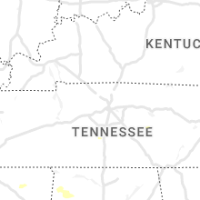
Kentucky
| Local Time | Report Details |
|---|---|
| 4:57 PM EDT | Photos of trees snapped posted on social media. time estimated from rada in campbell county KY, 4.8 miles SSE of Cincinnati, OH |
| 4:58 PM EDT | Observer watched trees snapped in 275/471 area. winds pushed cars into other lanes... causing accident in campbell county KY, 4.6 miles SSE of Cincinnati, OH |
| 6:10 PM EDT | Storm damage reported in boone county KY, 9.2 miles WSW of Cincinnati, OH |
Mississippi
| Local Time | Report Details |
|---|---|
| 4:07 PM CDT | Tree down across blaylock near broadwa in washington county MS, 69.1 miles NE of Bastrop, LA |
| 4:12 PM CDT | A utility pole was downed and the roof was blown off an apartment building in sha in bolivar county MS, 87.2 miles NE of Bastrop, LA |
| 4:21 PM CDT | Trees and power lines downed along ms 44 in sunflower county MS, 88 miles NNW of Jackson, MS |
| 9:37 PM UTC | Part of a tin roof blown off a building and into the lanes of us 49 in belzon in humphreys county MS, 63.5 miles NNW of Jackson, MS |
| 9:56 PM UTC | Two trees downed across howard r in holmes county MS, 56.7 miles N of Jackson, MS |
| 10:10 PM UTC | Tree downed across ms hwy 17 south of lexingto in holmes county MS, 52.2 miles NNE of Jackson, MS |
West Virginia
| Local Time | Report Details |
|---|---|
| 5:18 PM EDT | Quarter sized hail reported near Great Cacapon, WV, 83.7 miles SSW of State College, PA, national park service reported quarter sized hail near intersection of pearre road and woodmont road. |
| 6:54 PM EDT | Numerous trees down. em employee observed from straight line wind in mason county WV, 36.7 miles NW of Charleston, WV |
| 10:54 PM UTC | Several trees and power line down across the roa in mason county WV, 32.9 miles NW of Charleston, WV |
| 6:55 PM EDT | Em reports trees down in glenwood are in mason county WV, 33.6 miles WNW of Charleston, WV |
| 7:20 PM EDT | Quarter sized hail reported near Beverly, WV, 6.1 miles SSW of Elkins, WV |
| 11:23 PM UTC | Multiple trees blown down near buffal in putnam county WV, 26.9 miles NW of Charleston, WV |
| 11:25 PM UTC | Quarter sized hail reported near Paden City, WV, 75 miles NW of Elkins, WV |
| 11:30 PM UTC | Quarter sized hail reported near Red House, WV, 18.1 miles NNW of Charleston, WV, quarter size hail. estimated wind gusts between 40-50 mph. |
| 11:37 PM UTC | Barn blown completely down from strong wind... near the vicinity of confidence elementary schoo in putnam county WV, 17.6 miles NNW of Charleston, WV |
| 7:37 PM EDT | Quarter sized hail reported near Poca, WV, 17.6 miles NNW of Charleston, WV, quarter size hail reported. possible car damage. |
| 11:40 PM UTC | Quarter sized hail reported near New Martinsville, WV, 68.4 miles NW of Elkins, WV, 911 dispatcher drove through some hail along turkey run road near route 7. |
| 11:53 PM UTC | Trees and power lines blown down near the 6700 block along mcclane pik in putnam county WV, 18.1 miles NNW of Charleston, WV |
| 8:35 PM EDT | Golf Ball sized hail reported near Charleston, WV, 7 miles N of Charleston, WV, time estimated from radar. |
| 8:35 PM EDT | Golf Ball sized hail reported near Charleston, WV, 4.1 miles N of Charleston, WV, time estimated from radar. |
| 8:37 PM EDT | Quarter sized hail reported near Charleston, WV, 12.4 miles N of Charleston, WV |
| 8:45 PM EDT | Golf Ball sized hail reported near Charleston, WV, 3.8 miles NE of Charleston, WV |
| 8:48 PM EDT | Half Dollar sized hail reported near Morgantown, WV, 40.6 miles N of Elkins, WV |
| 8:53 PM EDT | Hen Egg sized hail reported near Morgantown, WV, 42.5 miles N of Elkins, WV |
| 8:55 PM EDT | Quarter sized hail reported near Reedsville, WV, 40.5 miles N of Elkins, WV |
| 8:55 PM EDT | Hen Egg sized hail reported near Masontown, WV, 43.3 miles N of Elkins, WV |
| 1:13 AM UTC | Quarter sized hail reported near Morgantown, WV, 45.5 miles NNW of Elkins, WV |
| 9:18 PM EDT | Ping Pong Ball sized hail reported near Morgantown, WV, 46.9 miles N of Elkins, WV |
| 9:25 PM EDT | Ping Pong Ball sized hail reported near Morgantown, WV, 45.4 miles N of Elkins, WV |
| 9:26 PM EDT | Ping Pong Ball sized hail reported near Morgantown, WV, 46 miles N of Elkins, WV |
| 1:27 AM UTC | Quarter sized hail reported near Masontown, WV, 46 miles N of Elkins, WV |
| 9:37 PM EDT | Ping Pong Ball sized hail reported near Masontown, WV, 44.6 miles N of Elkins, WV |
Florida
| Local Time | Report Details |
|---|---|
| 6:00 PM EDT | Brevard em reported a tree fell on a home at 478 carmel dr. in suntree florida. radar estiamted time was 6 p in brevard county FL, 46.9 miles ESE of Orlando, FL |
New Mexico
| Local Time | Report Details |
|---|---|
| 4:28 PM MDT | Quarter sized hail reported near San Ysidro, NM, 33 miles NNW of Albuquerque, NM, from speedway gas station employee. |
| 6:26 PM MDT | Wind gust at ktcs airpor in sierra county NM, 66.4 miles ENE of Silver City, NM |
| 6:29 PM MDT | Half Dollar sized hail reported near Eagle Nest, NM, 25.2 miles ENE of Taos, NM, along highway 64 near palisades sill historical marker. |
| 12:30 AM UTC | Quarter sized hail reported near White Sands Missile Range, NM, 42.8 miles N of El Paso, TX |
| 6:30 PM MDT | Quarter sized hail reported near White Sands Missile Range, NM, 42.8 miles N of El Paso, TX |
Maryland
| Local Time | Report Details |
|---|---|
| 6:28 PM EDT | Report of tree down on 6700 block of carlinda ave in howard county MD, 14.6 miles WSW of Baltimore, MD |
| 6:41 PM EDT | Tree down near ellicott mills dr and burgess mill way in howard county MD, 10.8 miles W of Baltimore, MD |
| 7:11 PM EDT | Report of 12" tree limb down on roadway on cradlerock way in howard county MD, 14.6 miles WSW of Baltimore, MD |
| 7:11 PM EDT | Report of tree down on 6200 block of star road in howard county MD, 14.3 miles WSW of Baltimore, MD |
| 7:27 PM EDT | Report of downed tree near ellcott mills dr and burgess mill way in howard county MD, 10.3 miles W of Baltimore, MD |
| 7:31 PM EDT | Report of tree down near silvan lane and church road in howard county MD, 10.3 miles W of Baltimore, MD |
| 8:01 PM EDT | Report of downed tree and multiple large trees limbs (some larger than 10" diameter) on roof of a residence in howard county MD, 14.3 miles WSW of Baltimore, MD |
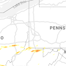
Pennsylvania
| Local Time | Report Details |
|---|---|
| 8:55 PM EDT | Hen Egg sized hail reported near Masontown, PA, 40.9 miles S of Pittsburgh, PA |
| 1:30 AM UTC | Sporadic reports of trees down across addison... upper turkeyfoot... and lower turkeyfoot township in somerset county PA, 55.7 miles SE of Pittsburgh, PA |
| 1:40 AM UTC | Trees and wires down along covered bridge road in middlecreek townshi in somerset county PA, 50.8 miles SE of Pittsburgh, PA |
Connect with Interactive Hail Maps