

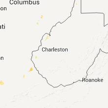
Hail Map for Saturday, May 14, 2011

Number of Impacted Households on 5/14/2011
0
Impacted by 1" or Larger Hail
0
Impacted by 1.75" or Larger Hail
0
Impacted by 2.5" or Larger Hail
Square Miles of Populated Area Impacted on 5/14/2011
0
Impacted by 1" or Larger Hail
0
Impacted by 1.75" or Larger Hail
0
Impacted by 2.5" or Larger Hail


Cities Most Affected by Hail Storms of 5/14/2011
| Hail Size | Demographics of Zip Codes Affected | ||||||
|---|---|---|---|---|---|---|---|
| City | Count | Average | Largest | Pop Density | House Value | Income | Age |
| Myrtle Beach, SC | 1 | 1.75 | 1.75 | 1032 | $0k | $0.0k | 38.8 |
Hail and Wind Damage Spotted on 5/14/2011
Filter by Report Type:Hail ReportsWind Reports
States Impacted
Florida, Georgia, South Carolina, Kentucky, North Carolina, Nevada, Virginia, West Virginia, Oregon, WashingtonFlorida
| Local Time | Report Details |
|---|---|
| 3:00 PM UTC | At least a dozen trees down in the central and southern part of the county. time was estimated by rada in madison county FL, 50.4 miles E of Tallahassee, FL |
| 3:40 PM UTC | 911 call center reported trees down in sanderson. time estimated from rada in baker county FL, 37.1 miles W of Jacksonville, FL |
| 3:41 PM UTC | 911 call center reported trees down on sw 101st avenue. time estimated from rada in bradford county FL, 42.3 miles SW of Jacksonville, FL |
| 3:45 PM UTC | 911 call center reported trees down on nw county road 229. time estimated from rada in bradford county FL, 38.3 miles SW of Jacksonville, FL |
| 3:50 PM UTC | 911 call center reported trees down in glen st mary. time estimated from rada in baker county FL, 30.4 miles W of Jacksonville, FL |
| 3:50 PM UTC | 911 call center reported trees down on se county road 18. time estimated from rada in bradford county FL, 42.5 miles SW of Jacksonville, FL |
| 4:00 PM UTC | 911 call center reported trees down on se county road 100a. time estimated from rada in bradford county FL, 38 miles SW of Jacksonville, FL |
| 4:05 PM UTC | 911 call center reported trees down in macclenny. time estimated from rada in baker county FL, 28.6 miles W of Jacksonville, FL |
| 4:37 PM UTC | *** 1 inj *** emergency manager reported a tree down on a mobile home on yellow bluff road which injured the residen in duval county FL, 9.9 miles NNE of Jacksonville, FL |
| 4:57 PM UTC | Six inch diameter tree limb down on pages dairy roa in nassau county FL, 21.2 miles NNE of Jacksonville, FL |
| 5:09 PM UTC | Power lines reported downed near avon park. numerous reports of damage received from across the count in highlands county FL, 65.7 miles S of Orlando, FL |
| 5:15 PM UTC | The public reported up to 6 trees down in the lakeshore mall are in highlands county FL, 66.8 miles E of Bradenton, FL |
| 5:15 PM UTC | A nws employee surveyed damage between citra and reddick and found it to be straight line winds. there was a mobile home with a roof peeled back and minor damage to sev in marion county FL, 72.4 miles SSW of Jacksonville, FL |
| 5:15 PM UTC | Quarter sized hail reported near Sebring, FL, 68.4 miles WNW of Port Saint Lucie, FL, reported dime to quarter size hail by sheriffs office. |
| 5:15 PM UTC | Quarter sized hail reported near Sebring, FL, 66.8 miles E of Bradenton, FL, the public reported quarter to golf ball sized hail at the lakeshore mall. |
| 5:38 PM UTC | Quarter sized hail reported near Keystone Heights, FL, 35.6 miles SSW of Jacksonville, FL, quarter size hail reported by trained spotter at a boy scout camp 2 miles east of state road 16 nar camp blanding. |
| 5:57 PM UTC | Measured by home weather station in pinellas county FL, 34.9 miles NNW of Bradenton, FL |
| 5:59 PM UTC | Measured by a home weather station in pinellas county FL, 32.1 miles NNW of Bradenton, FL |
| 6:00 PM UTC | Fire department reported 15-20 large oak and pine trees down at us 41 and cr 33 in levy county FL, 79.7 miles SW of Jacksonville, FL |
| 6:00 PM UTC | Ham radio operator reported trees down at sw 75th st. time estimated from rada in alachua county FL, 67.1 miles SW of Jacksonville, FL |
| 6:10 PM UTC | Several outhouses lost roofs and some palmetto palms down. dime hail also reporte in okeechobee county FL, 32.3 miles WNW of Port Saint Lucie, FL |
| 6:18 PM UTC | The 911 call center received numerous reports of trees and powerlines dow in alachua county FL, 65.1 miles SSW of Jacksonville, FL |
| 6:24 PM UTC | A trained spotter measured a 70 mph wind gust on their home weather statio in pinellas county FL, 23.6 miles NNW of Bradenton, FL |
| 6:29 PM UTC | 911 call center reported trees down on se county road 21b. time estimated from rada in alachua county FL, 46.3 miles SSW of Jacksonville, FL |
| 6:30 PM UTC | 6 inch dia in orange county FL, 4.1 miles E of Orlando, FL |
| 6:40 PM UTC | Public reported part of roof blown off of a building across from busch gardens. also tree limbs and railroad barriers blown dow in hillsborough county FL, 38.7 miles NNE of Bradenton, FL |
| 6:40 PM UTC | Public reported parts of a roof blown off across from busch gardens. also some tree limbs and railroad barriers dow in hillsborough county FL, 38.7 miles NNE of Bradenton, FL |
| 6:43 PM UTC | Estimated 50-60 mph wind with small to medium size branches dow in orange county FL, 10.1 miles WNW of Orlando, FL |
| 6:52 PM UTC | The ports station at old port tampa measured a wind gust of 66 knot in gmz830 county FL, 25.2 miles N of Bradenton, FL |
| 7:13 PM UTC | Several reports of power in sumter county FL, 45.3 miles W of Orlando, FL |
| 7:15 PM UTC | Palm coast fire rescue was dispatched for a tree on a house on willow lan in flagler county FL, 58.9 miles SSE of Jacksonville, FL |
| 7:19 PM UTC | Medium sized tree limbs down in downtown bushnel in sumter county FL, 45.4 miles WNW of Orlando, FL |
| 8:35 PM UTC | Palm beach county emergency management relayed reports of hail and downed powerlines/tree limbs along southern boulevard between lion country safari and 20-mile ben in palm beach county FL, 40.2 miles S of Port Saint Lucie, FL |
| 9:18 PM UTC | Quarter sized hail reported near Monticello, FL, 25.4 miles ENE of Tallahassee, FL |
| 10:35 PM UTC | Numerous trees down along u.s. highway 441 in northern section of columbia count in columbia county FL, 61.7 miles W of Jacksonville, FL |
| 10:45 PM UTC | Quarter sized hail reported near White Springs, FL, 63.3 miles WNW of Jacksonville, FL, a nws employee...who is an imet at the honey prairie wildfire...received a report of quarter sized hail along u.s. 441 south of fargo. the time and exact location was b |
| 11:30 PM UTC | Spotter reported a lane closure on us-90 eastbound between live oak and lake city due to a downed tree. time estimated from rada in suwannee county FL, 75.1 miles W of Jacksonville, FL |
| 11:30 PM UTC | 911 call center reported scattered trees and powerlines dow in baker county FL, 34.5 miles W of Jacksonville, FL |
| 11:45 PM UTC | Spotter reported power outages in live oak due to trees down on powerlines. time estimated from rada in suwannee county FL, 78.3 miles E of Tallahassee, FL |
| 1:17 AM UTC | A wind gust of 53 kts...or 61 mph...was recorded by a mesonet station at the new river middle school in fort lauderdale at 917 pm ed in broward county FL, 27.5 miles NNE of Miami, FL |
Georgia
| Local Time | Report Details |
|---|---|
| 3:50 PM UTC | Nws employee reported an awning tipped over at a gas station and a railroad track gate was snapped in fargo. plenty of branches and large limbs down in fargo as wel in clinch county GA, 58.8 miles SSE of Douglas, GA |
| 4:40 PM UTC | Quarter sized hail reported near Folkston, GA, 41.2 miles NNW of Jacksonville, FL, public report of penny to quarter size hail and several small limbs down at the folkston country club. |
| 4:45 PM UTC | St marys fire department reported a tree down on new point peter roa in camden county GA, 30.6 miles NNE of Jacksonville, FL |
| 5:14 PM UTC | The 911 call center received a report of an awning blown off a home and a powerline dow in camden county GA, 31.6 miles N of Jacksonville, FL |
| 7:27 PM UTC | Wilkinson county 911 reported several downed trees between toomsboro and nicklesvill in wilkinson county GA, 80.5 miles SW of Augusta, GA |
| 7:39 PM UTC | Laurens county 911 relayed a report of a downed tree at elmwood road and whispering pines lan in laurens county GA, 76.1 miles N of Douglas, GA |
| 7:48 PM UTC | Laurens county 911 relayed reports of a downed tree in the northern end of the county and a small storage building being blown across the road in dubli in laurens county GA, 71.6 miles N of Douglas, GA |
| 7:57 PM UTC | Laurens county 911 relayed a report of a downed tree on crestview dr and powell d in laurens county GA, 72.6 miles N of Douglas, GA |
| 8:02 PM UTC | Washington county 911 relayed a report of a downed tree on new tennille roa in washington county GA, 63.3 miles SW of Augusta, GA |
| 8:04 PM UTC | Johnson county emergency management estimated winds gusting to 60 mph in wrightsvill in johnson county GA, 67.3 miles SW of Augusta, GA |
| 8:08 PM UTC | Public reports power out briefly due to the stor in greene county GA, 68.7 miles W of Augusta, GA |
| 8:10 PM UTC | Johnson county emergency management estimated winds gusting to 60 mph in wrightsvill in johnson county GA, 67.3 miles SW of Augusta, GA |
| 8:35 PM UTC | Jefferson county 911 relayed a report of a tree downed onto a powerline in barto in jefferson county GA, 50.3 miles SW of Augusta, GA |
| 9:55 PM UTC | Quarter sized hail reported near Statenville, GA, 56.5 miles S of Douglas, GA, the sheriffs office reported quarter sized hail. |
| 9:55 PM UTC | The sheriffs office reported trees down along highways 129 and 135 sout in echols county GA, 56.5 miles S of Douglas, GA |
| 10:20 PM UTC | The 911 center received reports of trees down along adams avenue and also along douglas highway near denton. the time given was based on rada in jeff davis county GA, 19.5 miles NNE of Douglas, GA |
| 10:40 PM UTC | 911 call center confirmed several reports of trees down along highway 221 between denton and hazlehurs in jeff davis county GA, 24 miles NNE of Douglas, GA |
| 10:57 PM UTC | Middle georgia emc reports power out along antioch church road due to downed powerlines and blown transforme in wilcox county GA, 41.5 miles NW of Douglas, GA |
| 10:57 PM UTC | Middle georgia emc reported power outages along connor road due to several downed powerline in wilcox county GA, 49 miles NW of Douglas, GA |
| 11:09 PM UTC | Wilcox county emergency management relayed reports 2 downed trees just south of abbevill in wilcox county GA, 42.1 miles NW of Douglas, GA |
South Carolina
| Local Time | Report Details |
|---|---|
| 5:02 PM UTC | Quarter sized hail reported near Murrells Inlet, SC, 61.5 miles ENE of Charleston, SC, blackmoor golf course reported quarter inch hail. |
| 5:10 PM UTC | Half Dollar sized hail reported near Myrtle Beach, SC, 65.7 miles ENE of Charleston, SC, half dollar size hail reported by public. |
| 5:14 PM UTC | Large branches broken... no diameter give in horry county SC, 65.6 miles SW of Wilmington, NC |
| 5:20 PM UTC | Quarter sized hail reported near Myrtle Beach, SC, 65.6 miles SW of Wilmington, NC |
| 5:27 PM UTC | Golf Ball sized hail reported near Myrtle Beach, SC, 67.2 miles ENE of Charleston, SC, sheriff patrol cars sited golf ball size hail on socastee blvd. |
| 5:29 PM UTC | Quarter sized hail reported near Myrtle Beach, SC, 68.7 miles WSW of Wilmington, NC |
| 6:04 PM UTC | Carolina forest subdivision. siding and roof damage of a hom in horry county SC, 65.6 miles SW of Wilmington, NC |
Kentucky
| Local Time | Report Details |
|---|---|
| 5:12 PM UTC | Barn roof was blown off and carried a long distance. two trees were also blown down near glenmount cemetar in laurel county KY, 31.2 miles S of Irvine, KY |
| 6:49 PM UTC | Several trees uprooted at and near trailer par in floyd county KY, 66.6 miles E of Irvine, KY |
| 7:30 PM UTC | One tree down on spence branch road...near milo road intersectio in martin county KY, 58.6 miles WSW of Charleston, WV |
North Carolina
| Local Time | Report Details |
|---|---|
| 6:17 PM UTC | Quarter sized hail reported near Lumberton, NC, 67 miles WNW of Wilmington, NC, nickel to quarter size hail reported by spotter |
| 6:38 PM UTC | Tree down nc hwy 41. time estimated by radar in bladen county NC, 53.6 miles WNW of Wilmington, NC |
| 7:10 PM UTC | Multiple trees down in roseboro in sampson county NC, 58.1 miles S of Raleigh, NC |
| 7:12 PM UTC | Tree dow in robeson county NC, 62.9 miles WNW of Wilmington, NC |
| 7:12 PM UTC | Tree down off broad ridge and atkinso in robeson county NC, 62.9 miles WNW of Wilmington, NC |
| 7:13 PM UTC | Quarter sized hail reported near Durham, NC, 20.5 miles NW of Raleigh, NC, quarter sized hail |
| 7:14 PM UTC | Quarter sized hail reported near Durham, NC, 20.8 miles NW of Raleigh, NC, quarter sized hail |
| 7:15 PM UTC | Multiple trees down in salemburg in sampson county NC, 54.1 miles S of Raleigh, NC |
| 7:15 PM UTC | Trees down between roseboro and clinton on hwy 24 in sampson county NC, 56.9 miles SSE of Raleigh, NC |
| 7:23 PM UTC | Multiple trees down in clinton in sampson county NC, 57 miles SSE of Raleigh, NC |
| 7:35 PM UTC | Multiple trees down in turkey in sampson county NC, 53.9 miles NNW of Wilmington, NC |
| 7:40 PM UTC | Multiple trees down in newton grove in sampson county NC, 40.2 miles SSE of Raleigh, NC |
| 7:44 PM UTC | Quarter sized hail reported near Bullock, NC, 52 miles N of Raleigh, NC, quarter sized hail |
| 7:55 PM UTC | Tree down along popler road that totalled two vehicles in duplin county NC, 53.9 miles SSE of Raleigh, NC |
| 8:00 PM UTC | Trees down on highway 40 in duplin county NC, 54.8 miles SSE of Raleigh, NC |
| 8:00 PM UTC | Tree down on highway 117 in duplin county NC, 55.4 miles SSE of Raleigh, NC |
| 8:00 PM UTC | Damage to an out-building along bill clipton road in duplin county NC, 55.7 miles SSE of Raleigh, NC |
| 8:00 PM UTC | Trees down along mcneal road in duplin county NC, 55.7 miles SSE of Raleigh, NC |
| 8:15 PM UTC | Trees down in pikeville in wayne county NC, 42.2 miles ESE of Raleigh, NC |
| 8:25 PM UTC | Quarter sized hail reported near Kenansville, NC, 50 miles N of Wilmington, NC |
| 8:25 PM UTC | Quarter sized hail reported near Kenansville, NC, 50 miles N of Wilmington, NC |
| 8:34 PM UTC | Tree down in the 8000 block of hwy 42 in johnston county NC, 22.2 miles ESE of Raleigh, NC |
| 10:12 PM UTC | Power lines down in roanoke rapids on jewell st in halifax county NC, 71.3 miles S of Richmond, VA |
| 10:16 PM UTC | Power lines down in roanoke rapids on jewell st in halifax county NC, 71.3 miles S of Richmond, VA |
| 12:00 AM UTC | Tree down in surry county NC, 71.5 miles N of Charlotte, NC |
| 12:20 AM UTC | Tree down in the westfield community in surry county NC, 66.3 miles SW of Roanoke, VA |
| 12:25 AM UTC | Tree down in town in surry county NC, 64.8 miles SW of Roanoke, VA |
Nevada
| Local Time | Report Details |
|---|---|
| 9:03 PM UTC | Ruby valley raws sensor reported sustained wind of 45 mph with gust to 65 mph in elko county NV, 28.1 miles ESE of Elko, NV |
| 9:59 PM UTC | Bean flat monitor valley ndot sensor reported gust of 58 mph...appeared to be associated with convective showe in eureka county NV, 88.2 miles WNW of Ely, NV |
Virginia
| Local Time | Report Details |
|---|---|
| 10:15 PM UTC | Numerous large tree branches down in chesterfield county VA, 20 miles SE of Richmond, VA |
| 10:15 PM UTC | Numerous large tree branches down on bermuda orchard lane at okuma dr in chesterfield county VA, 20 miles SE of Richmond, VA |
| 10:45 PM UTC | Trees down in southampton county VA, 57.2 miles SSE of Richmond, VA |
West Virginia
| Local Time | Report Details |
|---|---|
| 11:00 PM UTC | Trees down in cemetar in ohio county WV, 43.7 miles SW of Pittsburgh, PA |
| 11:00 PM UTC | 39 trees down at oglebay resor in ohio county WV, 46.3 miles SW of Pittsburgh, PA |
Oregon
| Local Time | Report Details |
|---|---|
| 12:40 AM UTC | Quarter sized hail reported near Pendleton, OR, 35.9 miles SW of Walla Walla, WA, quarter sized hail and heavy rain on stage gulch road halfway between pendleton and hermiston. |
Washington
| Local Time | Report Details |
|---|---|
| 1:20 AM UTC | Microburst like wind gust blew trampoline over and kicked up several pieces of debris. several tree limbs 1 to 3 inches in diameter have falle in walla walla county WA, 32.2 miles WNW of Walla Walla, WA |
| 1:50 AM UTC | Richland airport recorded wind gust to 59 mp in benton county WA, 47.9 miles WNW of Walla Walla, WA |
Connect with Interactive Hail Maps