

Hail Map for Wednesday, November 16, 2011

Number of Impacted Households on 11/16/2011
0
Impacted by 1" or Larger Hail
0
Impacted by 1.75" or Larger Hail
0
Impacted by 2.5" or Larger Hail
Square Miles of Populated Area Impacted on 11/16/2011
0
Impacted by 1" or Larger Hail
0
Impacted by 1.75" or Larger Hail
0
Impacted by 2.5" or Larger Hail


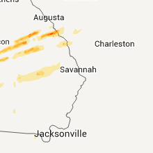


Cities Most Affected by Hail Storms of 11/16/2011
| Hail Size | Demographics of Zip Codes Affected | ||||||
|---|---|---|---|---|---|---|---|
| City | Count | Average | Largest | Pop Density | House Value | Income | Age |
| Albany, GA | 1 | 1.75 | 1.75 | 97 | $0k | $0.0k | 40.6 |
| Salisbury, NC | 1 | 1.75 | 1.75 | 786 | $90k | $32.2k | 37.5 |
Hail and Wind Damage Spotted on 11/16/2011
Filter by Report Type:Hail ReportsWind Reports
States Impacted
Louisiana, Alabama, Tennessee, Georgia, North Carolina, South Carolina, Virginia, FloridaLouisiana
| Local Time | Report Details |
|---|---|
| 12:15 PM UTC | Damage reported in kingspoint subdivision. trees snapped with one falling through roof of home. fences blown dow in st. tammany county LA, 29.6 miles NE of New Orleans, LA |
Alabama
| Local Time | Report Details |
|---|---|
| 1:04 PM UTC | Sheriff office reports trees down and homes damaged from a possible tornoado in the whitfield area near county road 42 and state road 1 in sumter county AL, 58.5 miles WNW of Camden, AL |
| 1:35 PM UTC | Structural roof damage reported in downtown demopolis. also a boat was overturned at a boat dealershi in marengo county AL, 48.5 miles NW of Camden, AL |
| 2:27 PM UTC | A roof was blown off of the porch at a residence at this locatio in lawrence county AL, 30.5 miles ESE of Florence, AL |
| 3:00 PM UTC | One-quarter mile swath of 6 inch diameter young pine tree trucks snapped off about 5 feet above the groun in clarke county AL, 31 miles W of Camden, AL |
| 3:07 PM UTC | Trees and power lines down from woody anderson ford to meridian stree in madison county AL, 53.3 miles E of Florence, AL |
| 3:15 PM UTC | 65 mph wind gust estimated in the providence area in madison county AL, 61.9 miles E of Florence, AL |
| 3:15 PM UTC | 65 mph wind gust estimated in the providence area in madison county AL, 55.5 miles E of Florence, AL |
| 3:15 PM UTC | 911 center in huntsville in madison county AL, 61.9 miles E of Florence, AL |
| 3:15 PM UTC | 911 center in northwest huntsvill in madison county AL, 56.7 miles E of Florence, AL |
| 3:17 PM UTC | A johnson high school sign was blown down. this is located at cecil fain drive and winchester road in northwest huntsville. time estimate in madison county AL, 60.6 miles E of Florence, AL |
| 3:25 PM UTC | Tree reported down on home in the northwest half of huntsville. a few power lines were also reported dow in madison county AL, 61.9 miles E of Florence, AL |
| 4:40 PM UTC | Power outages reported in hayneville as well as several trees down across the count in lowndes county AL, 43.6 miles ENE of Camden, AL |
| 5:02 PM UTC | Trees down in the cloverdale section of montgomery. possible tornado. time estimated from rada in montgomery county AL, 51 miles WSW of Auburn, AL |
| 5:07 PM UTC | Possible tornado. metal roof peeled off bui in montgomery county AL, 44.9 miles WSW of Auburn, AL |
| 5:22 PM UTC | Trees down on highway 97 after a strong circulation passed from southwest to northeas in crenshaw county AL, 55.2 miles E of Camden, AL |
| 5:27 PM UTC | Several trees down across rigsby rd just south of rifle range rd. possible tornad in elmore county AL, 31.7 miles WSW of Auburn, AL |
| 5:32 PM UTC | Several trees were blown down near shorte in macon county AL, 30.3 miles WSW of Auburn, AL |
| 5:42 PM UTC | Several trees were blown down in reeltow in tallapoosa county AL, 19.2 miles W of Auburn, AL |
| 5:52 PM UTC | Along whitman hill rd and county ro in macon county AL, 10 miles WSW of Auburn, AL |
| 6:00 PM UTC | Possible tornado. building blown dow in lee county AL, 6.3 miles WSW of Auburn, AL |
| 6:07 PM UTC | Possible tornado. significant damage at terrace acres apartment comple in lee county AL, 1.7 miles SE of Auburn, AL |
| 6:15 PM UTC | Possible tornado. major roof damage to in lee county AL, 5.4 miles E of Auburn, AL |
| 6:15 PM UTC | Possible tornado. major damage to trailer park. trailers and vehicles totally demolishe in lee county AL, 7.1 miles E of Auburn, AL |
| 6:35 PM UTC | Several buildings and boathouses were damaged along lake harding in lee county AL, 19.5 miles ENE of Auburn, AL |
| 8:50 PM UTC | 1 tree down at 12901 e county road 8. delayed report from wednesda in houston county AL, 63.5 miles NW of Tallahassee, FL |
| 8:55 PM UTC | 1 tree down at 102 5th avenue in ashford. delayed report from wednesda in houston county AL, 76.5 miles NW of Tallahassee, FL |
| 8:55 PM UTC | 1 tree down at 490 n state highway 95. delayed report from wednesda in houston county AL, 69.5 miles NW of Tallahassee, FL |
| 8:55 PM UTC | 1 tree down at 5832 old webb road. delayed report from wednesda in houston county AL, 82.8 miles NW of Tallahassee, FL |
Tennessee
| Local Time | Report Details |
|---|---|
| 4:15 PM UTC | Dispatch reported large tree limbs down and a tree blown across the road at the intersection of highway 28 and condra switch roa in marion county TN, 15.9 miles NW of Chattanooga, TN |
Georgia
| Local Time | Report Details |
|---|---|
| 6:30 PM UTC | 15 to 20 trees down...most near old federal rd nort in murray county GA, 34.7 miles ESE of Chattanooga, TN |
| 6:32 PM UTC | Cobb county 911 relayed reports of several downed trees in the marietta and smyrna areas. power outages were reported in the powder springs are in cobb county GA, 13.3 miles NNW of Atlanta, GA |
| 6:36 PM UTC | Harris county 911 relayed reports of numerous downed trees in the western portions of the count in harris county GA, 25.2 miles ENE of Auburn, AL |
| 6:41 PM UTC | *** 1 fatal *** forsyth county emergency management reported a tree downed onto a vehicle killing the occupan in forsyth county GA, 26.2 miles NNE of Atlanta, GA |
| 6:41 PM UTC | *** 1 inj *** forsyth county emergency management reported a tree downed onto a vehicle with injurie in forsyth county GA, 26.2 miles NNE of Atlanta, GA |
| 6:45 PM UTC | Possible tornado bent highway signs 90 degrees and caused very strong wind in harris county GA, 28.6 miles ENE of Auburn, AL |
| 6:54 PM UTC | Amatuer radio relayed a report of damage to the high school and cars in the parking lot of the high school. this damage is possibly the result of a tornad in harris county GA, 36.6 miles ENE of Auburn, AL |
| 7:10 PM UTC | Possible continuation of tornado from harris county. several downed trees and power lines in far northwest talbot county on old shiloh r in talbot county GA, 49.5 miles ENE of Auburn, AL |
| 7:10 PM UTC | Possible tornado downed trees and power lines in far nw talbot county on old shiloh r in talbot county GA, 49.5 miles ENE of Auburn, AL |
| 8:09 PM UTC | Monroe county 911 relayed reports of a few downed trees in between the forsyth and johnstonville area in monroe county GA, 51.5 miles SSE of Atlanta, GA |
| 8:23 PM UTC | Two trees down on hwy 12 in twiggs county GA, 86.6 miles SE of Atlanta, GA |
| 8:25 PM UTC | One tree down on i-1 in twiggs county GA, 86.7 miles SE of Atlanta, GA |
| 8:25 PM UTC | Several trees down on i-1 in twiggs county GA, 86.7 miles SE of Atlanta, GA |
| 8:52 PM UTC | Two trees dow in wilkinson county GA, 83.2 miles WSW of Augusta, GA |
| 8:52 PM UTC | Three trees dow in wilkinson county GA, 82.7 miles WSW of Augusta, GA |
| 9:09 PM UTC | Twiggs county 911 relayed reports of 2 downed trees along long street in the southern portion of the count in twiggs county GA, 77.5 miles NNW of Douglas, GA |
| 4:18 PM EST | Quarter sized hail reported near Sandersville, GA, 59.3 miles SW of Augusta, GA, public reports nickle to quarter sized hail in sandersville. |
| 4:41 PM EST | Golf Ball sized hail reported near Albany, GA, 82 miles N of Tallahassee, FL, law enforcement reports golf ball size hail in western lee county. |
| 9:50 PM UTC | Jefferson county relayed reports of 4 downed trees and 2 downed powerline in jefferson county GA, 36.5 miles SW of Augusta, GA |
| 9:53 PM UTC | Laurens county emergency management reported several downed trees in the northern part of the count in laurens county GA, 77.3 miles SW of Augusta, GA |
| 10:05 PM UTC | Ags asos reports 58 mph wind gust in richmond county GA, 6.8 miles S of Augusta, GA |
| 10:06 PM UTC | Six homes damaged...one significantly when a large pine tree fell through the structure. a portion of a carport blown up on the roof of a home. several pump houses bein in johnson county GA, 67.3 miles SW of Augusta, GA |
| 5:10 PM EST | Quarter sized hail reported near Wrightsville, GA, 67.3 miles SW of Augusta, GA, johnson county emergency management reported hail at least the size of quarters and strong gusty winds in wrightsville. |
| 10:31 PM UTC | Public report of storage building blown over in waynesboro - relayed by wrdw photo - time estimated with radar in burke county GA, 26.9 miles S of Augusta, GA |
| 10:42 PM UTC | 1 tree down on highway 97 sout in decatur county GA, 31 miles NW of Tallahassee, FL |
| 10:42 PM UTC | Trees down near 267 n pelham roa in decatur county GA, 37.1 miles NNW of Tallahassee, FL |
| 10:48 PM UTC | Trees down on jones road in decatur county GA, 29.1 miles NNW of Tallahassee, FL |
| 5:56 PM EST | Quarter sized hail reported near Midville, GA, 53 miles SSW of Augusta, GA, amateur radio relayed reports of trees blocking mcgarrs mill pond road and quarter-sized hail. |
| 10:56 PM UTC | Trees down on tired creek road in grady county GA, 24.9 miles N of Tallahassee, FL |
| 10:56 PM UTC | Trees down on old highway 179 in grady county GA, 41.6 miles N of Tallahassee, FL |
| 10:56 PM UTC | Trees down on open pond road in grady county GA, 35.2 miles N of Tallahassee, FL |
| 11:00 PM UTC | Trees down on whigham road in grady county GA, 39.3 miles N of Tallahassee, FL |
| 11:11 PM UTC | Jenkins county warning point reported one tree down along west old savannah road. time estimated by rada in jenkins county GA, 48 miles S of Augusta, GA |
| 11:30 PM UTC | 1 large pine tree down near highway 319 about 9 miles north of thomasville in between thomasville and coolidge. delayed report from wednesda in thomas county GA, 43.3 miles NNE of Tallahassee, FL |
| 11:39 PM UTC | Burke county em reports 3 recreational vehicles flipped over...powerlines down and a large tree blown onto the roof of a house near seven oak road and hwy 23 in the she in burke county GA, 23.1 miles S of Augusta, GA |
| 11:40 PM UTC | Screven county warning point reported 2 trees down on hiltonia creek road. time estimated by rada in screven county GA, 45.6 miles SSE of Augusta, GA |
| 11:44 PM UTC | Trained spotter reported several large pecan tree limbs down near lewis. time estimated by rada in screven county GA, 50.1 miles SSE of Augusta, GA |
| 11:48 PM UTC | Screven county warning point and trained spotter reported one tree down along highway 17 north. time estimated by rada in screven county GA, 57.4 miles S of Augusta, GA |
| 12:43 AM UTC | Roof blown off a barn along bolling road in lanier county GA, 33.7 miles SSW of Douglas, GA |
| 12:45 AM UTC | Tattnall county had numerous reports of trees down in collins. time estimated by rada in tattnall county GA, 60.2 miles W of Savannah, GA |
| 12:45 AM UTC | Tattnall county warning point reported a tree down on ward street. time estimated by rada in tattnall county GA, 60.2 miles W of Savannah, GA |
| 7:45 PM EST | Quarter sized hail reported near Collins, GA, 60.2 miles W of Savannah, GA, tattnall county warning point reported quarter-size hail at the intersection of highways 23 and 292. time estimated by radar. |
| 12:50 AM UTC | Tattnall county warning point reported a tree down on queen street. time estimated by rada in tattnall county GA, 54.8 miles W of Savannah, GA |
| 12:50 AM UTC | The emergency management reported that the trees down on highway 32 west 1 mile east of the county line was caused by straight line winds or a microburs in coffee county GA, 11.1 miles WNW of Douglas, GA |
| 12:50 AM UTC | Emergency management reported trees down on highway 32w about 1 mile east of the county line. debris was in the highway and the ema director was enrout in coffee county GA, 11.1 miles WNW of Douglas, GA |
| 12:51 AM UTC | 1 tree down across highway 135n in lanier county GA, 30.8 miles SSW of Douglas, GA |
| 1:00 AM UTC | Evans county warning point reported a tree down on clark street. time estimated by rada in evans county GA, 48.9 miles W of Savannah, GA |
| 1:15 AM UTC | The 911 center reported a tree blown down on a powerline just off of 441 north near homerville. the time given was based on rada in clinch county GA, 28.9 miles S of Douglas, GA |
| 8:15 PM EST | Quarter sized hail reported near Statesboro, GA, 53.8 miles NW of Savannah, GA, trained spotter reported quarter size hail for 3 minutes. |
| 1:28 AM UTC | Effingham county warning point reported trees down at the intersection of porter road and highway 17. time estimated by rada in effingham county GA, 29.1 miles NW of Savannah, GA |
| 1:35 AM UTC | Storm survey confirmed thunderstorm winds blew down a barn with sheet metal ripped off roof at 3661 luvett road. straight line winds estimated at 70 mph and damage was in ware county GA, 28.1 miles SE of Douglas, GA |
| 1:39 AM UTC | The 911 call center reported trees down along lovett road in waresboro. time is estimated from rada in ware county GA, 27.7 miles SE of Douglas, GA |
| 1:45 AM UTC | The 911 call center reported damage to roofs in the palmetto subdivision near cameron lane and us-1. time is estimated from rada in ware county GA, 29.3 miles ESE of Douglas, GA |
| 1:45 AM UTC | The 911 call center reported trees down along us-1 near waycross. time is estimated from rada in ware county GA, 30.6 miles ESE of Douglas, GA |
North Carolina
| Local Time | Report Details |
|---|---|
| 9:18 PM UTC | Trees reported down and possible damage to a mobile home off airport rd in s in cleveland county NC, 40 miles W of Charlotte, NC |
| 10:46 PM UTC | 1 tree reported down on vehicle just north of salisbur in rowan county NC, 38.6 miles NNE of Charlotte, NC |
| 5:48 PM EST | Quarter sized hail reported near Salisbury, NC, 36.9 miles NNE of Charlotte, NC, public reported up to 1 inch hail in sali |
| 5:52 PM EST | Quarter sized hail reported near Linwood, NC, 45 miles NE of Charlotte, NC, 1 hail near old salisbury road |
| 6:01 PM EST | Golf Ball sized hail reported near Salisbury, NC, 39.8 miles NNE of Charlotte, NC |
| 11:02 PM UTC | Trees down at hwy 704 and creasy r in stokes county NC, 54.5 miles SSW of Roanoke, VA |
| 11:03 PM UTC | Trees down at 2893 hart rd in stokes county NC, 56 miles SSW of Roanoke, VA |
| 11:06 PM UTC | Trees down 1946 hwy 704 east in stokes county NC, 53.9 miles SSW of Roanoke, VA |
| 11:06 PM UTC | Trees down at 2687 flat rock rd in stokes county NC, 66.5 miles SSW of Roanoke, VA |
| 11:11 PM UTC | Trees down at 1346 va line rd in stokes county NC, 52 miles SSW of Roanoke, VA |
| 11:14 PM UTC | Trees down at 3500 hwy 704 west in stokes county NC, 53.7 miles SSW of Roanoke, VA |
| 11:30 PM UTC | Trees down at intersection of north friendship rd and flat shoals rd in stokes county NC, 65.8 miles SSW of Roanoke, VA |
| 1:55 AM UTC | A large tree was reported down on stackhouse road. the time was estimated based on radar dat in robeson county NC, 68.1 miles WNW of Wilmington, NC |
| 1:55 AM UTC | Large trees were reported down on progressive farm road. the time was estimated based on radar dat in robeson county NC, 65 miles WNW of Wilmington, NC |
| 4:07 AM UTC | Two trees were uprooted just south of severn. several road signs were also damage in northampton county NC, 65.1 miles WSW of Virginia Beach, VA |
South Carolina
| Local Time | Report Details |
|---|---|
| 10:06 PM UTC | Tree reported on a vehicle on river rd near old ferry rd.also...neal shaols rd blocked with downed trees and power line in union county SC, 50.3 miles SW of Charlotte, NC |
| 11:43 PM UTC | Sheriff office reported trees down in the cities of barnwell...hilda...and blackvill in barnwell county SC, 38.7 miles ESE of Augusta, GA |
| 11:52 PM UTC | County sheriff reports trees down near ola in bamberg county SC, 49.9 miles ESE of Augusta, GA |
| 11:56 PM UTC | Allendale county warning point reported numerous trees and power lines down on barton rd...citadel st...blanton rd. time estimated by radar in allendale county SC, 50.3 miles SE of Augusta, GA |
| 12:00 AM UTC | Nws employee reported several trees down along highway 301. time estimated by rada in allendale county SC, 50.6 miles SE of Augusta, GA |
| 12:15 AM UTC | Hampton county warning point reported 2 trees down on deer road. time estimated by rada in hampton county SC, 52.9 miles N of Savannah, GA |
| 12:40 AM UTC | Trees down at old river road and coveside circle in calhoun county SC, 47.5 miles WNW of Charleston, SC |
| 1:00 AM UTC | A large tree was reported down on manning highway. the time was estimated by radar dat in williamsburg county SC, 34 miles N of Charleston, SC |
| 1:10 AM UTC | Trees down at intersection of sc hwy 6 and hampton street in orangeburg county SC, 39.6 miles NW of Charleston, SC |
| 1:10 AM UTC | A large tree was reported down on mcclam road. the time was estimated based on radar dat in williamsburg county SC, 37.4 miles N of Charleston, SC |
| 1:15 AM UTC | Storm damage reported in williamsburg county SC, 37.1 miles NNE of Charleston, SC |
| 1:20 AM UTC | A large tree was reported down on cedar swamp road. the time was estimated based on radar dat in williamsburg county SC, 37 miles NNE of Charleston, SC |
| 1:27 AM UTC | A large tree was reported down at the intersection of bartells road and old georgetown road. the time was estimated based on radar dat in williamsburg county SC, 46.2 miles NNE of Charleston, SC |
| 1:54 AM UTC | Used car dealership sign blown over damaging three cars. time estimated based off rada in marion county SC, 74.1 miles W of Wilmington, NC |
Virginia
| Local Time | Report Details |
|---|---|
| 11:56 PM UTC | Extensive roof damage to unique industries. numerous tractor trailers blown ove in pittsylvania county VA, 47.6 miles SE of Roanoke, VA |
| 12:00 AM UTC | Trees down and water tanks tossed about on carter lodge roa in pittsylvania county VA, 48.4 miles SE of Roanoke, VA |
| 12:13 AM UTC | Two trees blown down on stage coach road in halifax county VA, 54.4 miles ESE of Roanoke, VA |
| 12:16 AM UTC | Tree blown down on clarkton roa in halifax county VA, 62.6 miles ESE of Roanoke, VA |
| 12:24 AM UTC | About 5 trees had their tops snapped off and powerlines were blown down. a trampoline and a metal sheet shed were blown away into a in halifax county VA, 63.4 miles ESE of Roanoke, VA |
| 12:36 AM UTC | Tree blown down on rodgers chapel road in halifax county VA, 71.1 miles N of Raleigh, NC |
| 12:40 AM UTC | Tree down in buckingham county VA, 47.2 miles WSW of Richmond, VA |
| 1:18 AM UTC | Tree blown down on ashe avenu in halifax county VA, 64.5 miles NNW of Raleigh, NC |
| 1:25 AM UTC | Tree down near the intersection of rt 614 and rt 615 in amelia county VA, 25.6 miles SW of Richmond, VA |
| 2:00 AM UTC | Several trees down north of dinwiddi in dinwiddie county VA, 27.9 miles S of Richmond, VA |
| 3:00 AM UTC | Several trees down north of dinwiddi in dinwiddie county VA, 27.9 miles S of Richmond, VA |
Florida
| Local Time | Report Details |
|---|---|
| 3:00 AM UTC | Damage was reported to a shed and shingles were torn from roof of a house at 4976 nw 42nd place. several trees down with numerous potted plants knocked over. a 3/4 inch in hamilton county FL, 66.4 miles E of Tallahassee, FL |
Connect with Interactive Hail Maps