

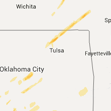
Hail Map for Thursday, November 5, 2015

Number of Impacted Households on 11/5/2015
0
Impacted by 1" or Larger Hail
0
Impacted by 1.75" or Larger Hail
0
Impacted by 2.5" or Larger Hail
Square Miles of Populated Area Impacted on 11/5/2015
0
Impacted by 1" or Larger Hail
0
Impacted by 1.75" or Larger Hail
0
Impacted by 2.5" or Larger Hail


Cities Most Affected by Hail Storms of 11/5/2015
| Hail Size | Demographics of Zip Codes Affected | ||||||
|---|---|---|---|---|---|---|---|
| City | Count | Average | Largest | Pop Density | House Value | Income | Age |
| Decatur, TX | 2 | 2.25 | 2.75 | 49 | $95k | $42.7k | 38.1 |
| Rhome, TX | 1 | 2.00 | 2.00 | 116 | $119k | $45.6k | 34.3 |
| Ponder, TX | 1 | 1.75 | 1.75 | 71 | $109k | $53.4k | 36.1 |
| Altamont, KS | 1 | 1.75 | 1.75 | 16 | $53k | $36.2k | 38.7 |
Hail and Wind Damage Spotted on 11/5/2015
Filter by Report Type:Hail ReportsWind Reports
Oklahoma
| Local Time | Report Details |
|---|---|
| 10:31 AM CST | Quarter sized hail reported near Yukon, OK, 13 miles W of Oklahoma City, OK, quarter size hail reported at the intersection of sw 15th and cemetery road. |
| 10:40 AM CST | Quarter sized hail reported near Mustang, OK, 12.6 miles WSW of Oklahoma City, OK |
| 11:54 AM CST | Quarter sized hail reported near Bartlesville, OK, 41.4 miles N of Tulsa, OK |
| 12:09 PM CST | Utility pole blown down on north flood av in cleveland county OK, 15.6 miles S of Oklahoma City, OK |
| 12:27 PM CST | Quarter sized hail reported near Newalla, OK, 17.2 miles SE of Oklahoma City, OK, quarter hail and very strong winds at the intersection of se 134th street and s choctaw road |
| 12:33 PM CST | Six utility poles snapped at harrah high schoo in oklahoma county OK, 20.4 miles E of Oklahoma City, OK |
| 12:35 PM CST | Quarter sized hail reported near Harrah, OK, 20.4 miles E of Oklahoma City, OK |
| 12:35 PM CST | Ping Pong Ball sized hail reported near Harrah, OK, 20.6 miles E of Oklahoma City, OK, reported in newalla. |
| 12:50 PM CST | Tree blown down and damaged power lin in mcclain county OK, 39.7 miles SSE of Oklahoma City, OK |
| 1:02 PM CST | Metal barns heavily damaged along highway 81. location and time estimate in jefferson county OK, 33 miles ENE of Wichita Falls, TX |
| 1:28 PM CST | Power poles blown down near ringlin in jefferson county OK, 55.5 miles ENE of Wichita Falls, TX |
| 2:55 PM CST | Tree and utility line damag in hughes county OK, 50.3 miles NNW of Atoka, OK |
| 6:54 PM CST | Trees down in the reichert communit in le flore county OK, 41.9 miles SSW of Fort Smith, AR |
| 7:05 PM CST | Power lines down on highway 59 in le flore county OK, 33.6 miles SSW of Fort Smith, AR |
| 7:06 PM CST | Trees down on morris creek roa in le flore county OK, 33.6 miles SSW of Fort Smith, AR |
| 9:32 PM CST | Storm damage reported in mccurtain county OK, 46.7 miles W of Nashville, AR |
| 9:35 PM CST | Trees and power lines down along hwy 3 near intersection with bokhoma road in mccurtain county OK, 45.3 miles W of Nashville, AR |
Kansas
| Local Time | Report Details |
|---|---|
| 12:24 PM CST | Quarter sized hail reported near Coffeyville, KS, 45.4 miles SSW of Chanute, KS, reported in town. |
| 12:45 PM CST | Golf Ball sized hail reported near Altamont, KS, 34.6 miles S of Chanute, KS, quarter to golfball size. lots of quarter size. |
| 1:16 PM CST | Quarter sized hail reported near Girard, KS, 32.5 miles ESE of Chanute, KS |
| 1:20 PM CST | Quarter sized hail reported near Girard, KS, 36.4 miles ESE of Chanute, KS, quarter hail reported at natures corner preschool. |
| 1:20 PM CST | Based on multiple videos and eyewitness accounts of an emergency management official...a microburst produced damage across the town of girard. several trees were downed in crawford county KS, 35.6 miles ESE of Chanute, KS |
| 1:40 PM CST | Ping Pong Ball sized hail reported near Burlington, KS, 44.1 miles NNW of Chanute, KS |
| 2:00 PM CST | Quarter sized hail reported near Melvern, KS, 58 miles N of Chanute, KS |
Texas
| Local Time | Report Details |
|---|---|
| 4:15 PM CST | Debris noted near beach street and highway 820 in north fort wort in tarrant county TX, 27.7 miles W of Dallas, TX |
| 4:30 PM CST | Pictures of roof damage near i-35w and i-82 in tarrant county TX, 27.7 miles W of Dallas, TX |
| 4:30 PM CST | Damage to commerical building sign 2800 block of deen road fort worth/time estimated via radar in tarrant county TX, 31.7 miles W of Dallas, TX |
| 5:04 PM CST | Quarter sized hail reported near Decatur, TX, 56.1 miles NW of Dallas, TX, quarter size hail in decatur. report relayed via ham radio operator. |
| 5:09 PM CST | Quarter sized hail reported near Valley View, TX, 53 miles NNW of Dallas, TX, quarter size hail just se of valley view. |
| 5:10 PM CST | Baseball sized hail reported near Decatur, TX, 56.1 miles NW of Dallas, TX, damage to police vehicles |
| 5:10 PM CST | Golf Ball sized hail reported near Decatur, TX, 56.1 miles NW of Dallas, TX, estimated golf ball size hail report via sm in decatur. |
| 5:13 PM CST | Hen Egg sized hail reported near Rhome, TX, 50.5 miles WNW of Dallas, TX, golf ball to hen egg size hail reported just se of decatur by off duty nws meteorologist. |
| 5:25 PM CST | Quarter sized hail reported near Krum, TX, 43 miles NW of Dallas, TX, one inch hail 2 miles north of krum. |
| 5:27 PM CST | Roof damage to mobile home in krum/time estimated via radar in denton county TX, 43 miles NW of Dallas, TX |
| 5:47 PM CST | Golf Ball sized hail reported near Ponder, TX, 40.3 miles NW of Dallas, TX, golf ball sized hail just west of ponder on hwy 156. |
| 5:56 PM CST | Storm damage reported in denton county TX, 36.8 miles NW of Dallas, TX |
| 6:03 PM CST | 3 light poles snapped at ponder high school in denton county TX, 40.3 miles NW of Dallas, TX |
| 7:20 PM CST | Powerlines down along hwy 155... near fm 344 and fm 266 in smith county TX, 72.2 miles NW of Lufkin, TX |
Arkansas
| Local Time | Report Details |
|---|---|
| 5:57 PM CST | Power line down on 44th streeet between north m and n street in sebastian county AR, 1.3 miles ENE of Fort Smith, AR |
Wisconsin
| Local Time | Report Details |
|---|---|
| 11:20 PM CST | 5 inch diameter tree branch down in waukesha county WI, 49.9 miles E of Madison, WI |
Connect with Interactive Hail Maps