

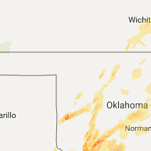
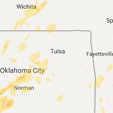
Hail Map for Saturday, October 21, 2017

Number of Impacted Households on 10/21/2017
0
Impacted by 1" or Larger Hail
0
Impacted by 1.75" or Larger Hail
0
Impacted by 2.5" or Larger Hail
Square Miles of Populated Area Impacted on 10/21/2017
0
Impacted by 1" or Larger Hail
0
Impacted by 1.75" or Larger Hail
0
Impacted by 2.5" or Larger Hail


Cities Most Affected by Hail Storms of 10/21/2017
| Hail Size | Demographics of Zip Codes Affected | ||||||
|---|---|---|---|---|---|---|---|
| City | Count | Average | Largest | Pop Density | House Value | Income | Age |
| Headrick, OK | 4 | 2.56 | 3.00 | 3 | $63k | $39.5k | 46.4 |
| Manitou, OK | 2 | 2.25 | 2.75 | 0 | $20k | $31.5k | 42.3 |
| Indiahoma, OK | 1 | 3.00 | 3.00 | 11 | $56k | $33.4k | 39.8 |
| Sweetwater, TX | 1 | 1.75 | 1.75 | 44 | $37k | $26.3k | 38.7 |
| Roosevelt, OK | 1 | 1.75 | 1.75 | 2 | $27k | $26.9k | 50.7 |
| Oklahoma City, OK | 1 | 1.75 | 1.75 | 2561 | $69k | $36.8k | 33.9 |
Hail and Wind Damage Spotted on 10/21/2017
Filter by Report Type:Hail ReportsWind Reports
Kansas
| Local Time | Report Details |
|---|---|
| 3:55 PM CDT | Quarter sized hail reported near Wichita, KS, 4.2 miles E of Wichita, KS, estimated quarter size hail observed 13th and k-96. report received via social media. |
| 4:17 PM CDT | Quarter sized hail reported near Americus, KS, 46.3 miles SSE of Manhattan, KS, social media report. |
| 6:11 PM CDT | Power line down at new york and 13th s in douglas county KS, 36.2 miles WSW of Kansas City, MO |
Oklahoma
| Local Time | Report Details |
|---|---|
| 4:20 PM CDT | Golf Ball sized hail reported near Roosevelt, OK, 71.4 miles NNW of Wichita Falls, TX |
| 4:40 PM CDT | Quarter sized hail reported near Frederick, OK, 47.3 miles NW of Wichita Falls, TX |
| 4:57 PM CDT | Tea Cup sized hail reported near Headrick, OK, 61.7 miles NW of Wichita Falls, TX |
| 5:03 PM CDT | Golf Ball sized hail reported near Headrick, OK, 61.7 miles NW of Wichita Falls, TX, windshield damage reported. |
| 5:12 PM CDT | Baseball sized hail reported near Headrick, OK, 61.7 miles NW of Wichita Falls, TX |
| 5:14 PM CDT | Golf Ball sized hail reported near Manitou, OK, 49.7 miles NNW of Wichita Falls, TX |
| 5:20 PM CDT | Baseball sized hail reported near Manitou, OK, 49.7 miles NNW of Wichita Falls, TX |
| 5:25 PM CDT | Ping Pong Ball sized hail reported near Elk City, OK, 70.6 miles S of Woodward, OK |
| 5:28 PM CDT | Baseball sized hail reported near Headrick, OK, 61.7 miles NW of Wichita Falls, TX, roof damage and broken windshield damage reported. |
| 5:29 PM CDT | Quarter sized hail reported near Goltry, OK, 69.9 miles E of Woodward, OK |
| 6:00 PM CDT | Tea Cup sized hail reported near Indiahoma, OK, 52.4 miles NNW of Wichita Falls, TX, location approximate. |
| 6:10 PM CDT | Powerpoles partially down. time estimated by rada in comanche county OK, 50 miles N of Wichita Falls, TX |
| 6:19 PM CDT | Powerpoles partially dow in comanche county OK, 50 miles N of Wichita Falls, TX |
| 7:15 PM CDT | Storm damage reported in caddo county OK, 58.3 miles SW of Oklahoma City, OK |
| 7:40 PM CDT | Storm damage reported in osage county OK, 56.4 miles NW of Tulsa, OK |
| 7:45 PM CDT | Reported very heavy rainfall and 60 mph wind in osage county OK, 55.4 miles NW of Tulsa, OK |
| 8:14 PM CDT | Estimated 55-65 mp in grady county OK, 20.1 miles SW of Oklahoma City, OK |
| 8:30 PM CDT | Quarter sized hail reported near Blanchard, OK, 20.1 miles SW of Oklahoma City, OK |
| 8:30 PM CDT | Sheet metal debris in side roadway off of hwy 4... south of fox lane and to the west. time estimated by rada in grady county OK, 19.3 miles SW of Oklahoma City, OK |
| 8:45 PM CDT | Quarter sized hail reported near Oklahoma City, OK, 8.6 miles S of Oklahoma City, OK, social media. |
| 8:47 PM CDT | Quarter sized hail reported near Oklahoma City, OK, 7.7 miles S of Oklahoma City, OK |
| 8:50 PM CDT | Quarter sized hail reported near Oklahoma City, OK, 11.3 miles S of Oklahoma City, OK, social media. |
| 8:50 PM CDT | Golf Ball sized hail reported near Oklahoma City, OK, 6.3 miles SW of Oklahoma City, OK, in southwest oklahoma city. |
| 8:52 PM CDT | Ping Pong Ball sized hail reported near Oklahoma City, OK, 9.8 miles S of Oklahoma City, OK |
| 8:54 PM CDT | Storm damage reported in stephens county OK, 51.9 miles NE of Wichita Falls, TX |
| 8:59 PM CDT | Storm damage reported in washington county OK, 44.9 miles N of Tulsa, OK |
| 9:11 PM CDT | Quarter sized hail reported near Duncan, OK, 51.2 miles NE of Wichita Falls, TX |
| 9:53 PM CDT | Tree and powerline damage in seminole. possible tornad in seminole county OK, 50.3 miles ESE of Oklahoma City, OK |
| 11:16 PM CDT | Quarter sized hail reported near Wagoner, OK, 37.3 miles ESE of Tulsa, OK |
| 11:40 PM CDT | 12 inch diameter tree downe in bryan county OK, 43.3 miles SSW of Atoka, OK |
| 11:53 PM CDT | Storm damage reported in sequoyah county OK, 37.7 miles WNW of Fort Smith, AR |
| 12:48 AM CDT | Report of a roof blown off a house in le flore county OK, 24.8 miles WSW of Fort Smith, AR |
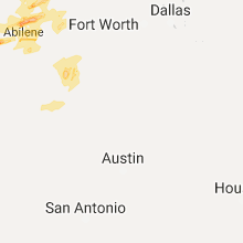
Texas
| Local Time | Report Details |
|---|---|
| 5:10 PM CDT | West texas mesonet observation in cochran county TX, 45.7 miles WSW of Lubbock, TX |
| 6:41 PM CDT | Quarter sized hail reported near Quanah, TX, 24.9 miles ESE of Childress, TX |
| 6:46 PM CDT | Quarter sized hail reported near Quanah, TX, 28.4 miles ESE of Childress, TX |
| 7:21 PM CDT | Quarter sized hail reported near Electra, TX, 25.5 miles WNW of Wichita Falls, TX |
| 7:25 PM CDT | Golf Ball sized hail reported near Sweetwater, TX, 39.1 miles W of Abilene, TX, golf ball size hail in sweetwater. |
| 7:42 PM CDT | A few powerlines dow in wichita county TX, 25.5 miles WNW of Wichita Falls, TX |
| 7:46 PM CDT | Quarter sized hail reported near Electra, TX, 25.5 miles WNW of Wichita Falls, TX |
| 8:25 PM CDT | Ping Pong Ball sized hail reported near Throckmorton, TX, 60 miles NNE of Abilene, TX, ping pong ball size hail in throckmorton. |
| 8:58 PM CDT | Quarter sized hail reported near Anson, TX, 23.3 miles NNW of Abilene, TX, quarter size hail in anson. |
| 11:08 PM CDT | Quarter sized hail reported near Abilene, TX, 0.7 miles E of Abilene, TX, quarter size hail in south abilene. |
Iowa
| Local Time | Report Details |
|---|---|
| 9:20 PM CDT | Power lines down and machine shop/shed damaged near intersection of urbana ave and highway 23. road blocked due to downed power lines. delayed repor in mahaska county IA, 64.6 miles ESE of Des Moines, IA |
Missouri
| Local Time | Report Details |
|---|---|
| 10:29 PM CDT | A phone line was blown down in the city of nevada. a pickup truck pulling a twenty foot trail was also blown off the road into the median two miles south of nevad in vernon county MO, 60.8 miles E of Chanute, KS |
| 10:30 PM CDT | Thunderstorm winds estimated 60+ mph and almost blew vehicle off roadwa in vernon county MO, 63.1 miles ENE of Chanute, KS |
| 10:38 PM CDT | A utility trailer was flipped over due to strong winds in walke in vernon county MO, 68.5 miles ENE of Chanute, KS |
| 11:10 PM CDT | Power line reported to have been blown down in the town of jasper missour in jasper county MO, 56.3 miles W of Springfield, MO |
| 11:10 PM CDT | Power line was reported downed in carthage. this is a correction of the previous lsr for the location of the down power line being in carthage not in the town of jasper in jasper county MO, 56.3 miles W of Springfield, MO |
| 11:40 PM CDT | Big tree down and onto the highway just east of the old drive-in in lockwoo in dade county MO, 38.4 miles WNW of Springfield, MO |
| 11:45 PM CDT | A few trees down east of jane along highway 9 in mcdonald county MO, 69 miles SW of Springfield, MO |
| 12:42 AM CDT | Powerline down in springfield near missouri st. and kearne in greene county MO, 2.2 miles NNW of Springfield, MO |
| 1:16 AM CDT | Southside of fair grov in greene county MO, 14.5 miles NE of Springfield, MO |
| 1:24 AM CDT | Storm damage reported in taney county MO, 36.4 miles SSE of Springfield, MO |
| 1:27 AM CDT | Dispatch had 3 trees down in the forsyth area due to thunderstorm wind in taney county MO, 37.7 miles SSE of Springfield, MO |
| 1:40 AM CDT | Damage to ham radio towe in webster county MO, 29.1 miles E of Springfield, MO |
| 2:30 AM CDT | Dispatch reported several trees down in the southern part of laclede county including the falcon and competition area in laclede county MO, 46.4 miles W of Salem, MO |
| 2:50 AM CDT | Storm damage reported in ozark county MO, 63.5 miles SE of Springfield, MO |
| 3:33 AM CDT | Tree down on e hwy just north of moody in howell count in howell county MO, 78.7 miles SSW of Salem, MO |
Arkansas
| Local Time | Report Details |
|---|---|
| 12:57 AM CDT | Fort smith regional airport in sebastian county AR, 1.3 miles ENE of Fort Smith, AR |
| 1:05 AM CDT | Roof damage to two buildings and trees reported down in sebastian county AR, 1.3 miles ENE of Fort Smith, AR |
| 1:07 AM CDT | Considerable tree damage in sebastian county AR, 7.8 miles ESE of Fort Smith, AR |
| 1:07 AM CDT | Storm damage reported in sebastian county AR, 15.6 miles SE of Fort Smith, AR |
| 1:16 AM CDT | Storm damage reported in sebastian county AR, 4.1 miles ESE of Fort Smith, AR |
| 1:20 AM CDT | Numerous streets in the city blocked due to trees dow in franklin county AR, 22.3 miles ESE of Fort Smith, AR |
| 1:21 AM CDT | Some trees were blown dow in scott county AR, 24.4 miles SSE of Fort Smith, AR |
| 1:25 AM CDT | Quarter sized hail reported near Charleston, AR, 22.3 miles ESE of Fort Smith, AR |
| 1:39 AM CDT | Some trees were blown down in booneville in logan county AR, 33 miles ESE of Fort Smith, AR |
| 1:41 AM CDT | Tree limbs were blown down south of caulksville in logan county AR, 31.8 miles ESE of Fort Smith, AR |
| 1:56 AM CDT | Trees and powerlines blown dow in johnson county AR, 43.5 miles ENE of Fort Smith, AR |
| 2:07 AM CDT | Trees were blown down around clarksvill in johnson county AR, 53.9 miles E of Fort Smith, AR |
| 2:15 AM CDT | Power lines and multiple trees were blown down near range in yell county AR, 63.8 miles ESE of Fort Smith, AR |
| 2:25 AM CDT | Multiple trees were blown down. several roads were blocked by fallen tree in yell county AR, 57.9 miles WNW of Little Rock, AR |
| 2:39 AM CDT | Winds caused damage to a roof and canopy of a gas statio in pope county AR, 65.3 miles NW of Little Rock, AR |
| 2:40 AM CDT | A power line was blown down between dardanelle and bethel roa in yell county AR, 60.8 miles WNW of Little Rock, AR |
| 3:08 AM CDT | Storm damage reported in perry county AR, 35.8 miles NW of Little Rock, AR |
| 3:15 AM CDT | A tree was blown dow in van buren county AR, 54.4 miles NNW of Little Rock, AR |
| 3:20 AM CDT | Limbs were blown down in van buren county AR, 55.4 miles NNW of Little Rock, AR |
| 3:32 AM CDT | Limbs were blown dow in faulkner county AR, 40.2 miles N of Little Rock, AR |
| 3:40 AM CDT | Multiple trees were blown down throughout the count in saline county AR, 22.2 miles SW of Little Rock, AR |
| 4:45 AM CDT | A power line was blown dow in white county AR, 43.7 miles NE of Little Rock, AR |
| 4:48 AM CDT | A tree was blown dow in white county AR, 43.7 miles NE of Little Rock, AR |
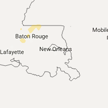
Louisiana
| Local Time | Report Details |
|---|---|
| 1:25 AM CDT | Trees uprooted near intersection of hwy 90 and weeks island road. time estimated from rada in iberia county LA, 19.8 miles SE of Lafayette, LA |
Connect with Interactive Hail Maps