

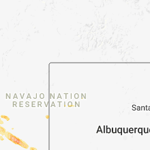
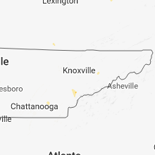
Hail Map for Saturday, September 1, 2018

Number of Impacted Households on 9/1/2018
0
Impacted by 1" or Larger Hail
0
Impacted by 1.75" or Larger Hail
0
Impacted by 2.5" or Larger Hail
Square Miles of Populated Area Impacted on 9/1/2018
0
Impacted by 1" or Larger Hail
0
Impacted by 1.75" or Larger Hail
0
Impacted by 2.5" or Larger Hail


Cities Most Affected by Hail Storms of 9/1/2018
| Hail Size | Demographics of Zip Codes Affected | ||||||
|---|---|---|---|---|---|---|---|
| City | Count | Average | Largest | Pop Density | House Value | Income | Age |
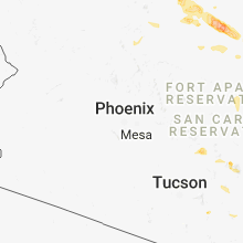
| Sun Valley, AZ | 2 | 2.25 | 2.75 | 0 | $0k | $0.0k | 26.0 |
| Des Moines, IA | 2 | 1.88 | 2.00 | 1582 | $76k | $40.3k | 36.6 |
| Bondurant, IA | 2 | 1.75 | 1.75 | 119 | $108k | $55.5k | 31.5 |
| Leupp, AZ | 1 | 2.50 | 2.50 | 0 | $51k | $17.3k | 34.9 |
| Luray, KS | 1 | 2.50 | 2.50 | 1 | $18k | $24.1k | 49.7 |
| Hays, KS | 1 | 2.00 | 2.00 | 62 | $91k | $32.5k | 30.5 |
| Urbandale, IA | 1 | 2.00 | 2.00 | 2954 | $127k | $57.3k | 39.4 |
| Amarillo, TX | 1 | 1.75 | 1.75 | 126 | $120k | $43.0k | 34.1 |
Hail and Wind Damage Spotted on 9/1/2018
Filter by Report Type:Hail ReportsWind Reports
States Impacted
Iowa, Illinois, Tennessee, Virginia, Florida, North Carolina, New Mexico, Ohio, Arizona, Kansas, Michigan, Texas, NebraskaIowa
| Local Time | Report Details |
|---|---|
| 7:22 AM CDT | Quarter sized hail reported near Menlo, IA, 40.9 miles W of Des Moines, IA, winds estimated to be 60 mph. |
| 7:05 PM CDT | Quarter sized hail reported near Grimes, IA, 11.4 miles NW of Des Moines, IA, via social media. |
| 7:10 PM CDT | Hen Egg sized hail reported near Urbandale, IA, 6.4 miles NW of Des Moines, IA |
| 7:11 PM CDT | Quarter sized hail reported near Johnston, IA, 8.8 miles NW of Des Moines, IA |
| 7:20 PM CDT | Ping Pong Ball sized hail reported near Des Moines, IA, 4.9 miles N of Des Moines, IA, reported at saydel high school. |
| 7:30 PM CDT | Half Dollar sized hail reported near Johnston, IA, 8.1 miles NW of Des Moines, IA |
| 7:38 PM CDT | Quarter sized hail reported near Des Moines, IA, 5.6 miles NE of Des Moines, IA |
| 7:40 PM CDT | Golf Ball sized hail reported near Des Moines, IA, 5.2 miles NE of Des Moines, IA, reported at delaware township fd. |
| 7:42 PM CDT | Hen Egg sized hail reported near Des Moines, IA, 4.5 miles NE of Des Moines, IA, reported in norwoodville neighborhood in des moines. via who tv. time estimated. |
| 7:47 PM CDT | Golf Ball sized hail reported near Bondurant, IA, 10.6 miles NE of Des Moines, IA, via social media. |
| 7:48 PM CDT | Golf Ball sized hail reported near Bondurant, IA, 10.7 miles NE of Des Moines, IA, via mping. time estimated. |
| 9:15 PM CDT | Awos station ffl... fairfield arp in jefferson county IA, 45.5 miles NNW of Kahoka, MO |
| 9:30 PM CDT | Storm damage reported in montgomery county IA, 39.5 miles ESE of Omaha, NE |
Illinois
| Local Time | Report Details |
|---|---|
| 8:15 AM CDT | Several large trees and tree limbs down in a very localized area of the belmont heights neighborhood on the far northwest side of chicago. most of the damage focused ne in cook county IL, 10.4 miles WNW of Chicago, IL |
Tennessee
| Local Time | Report Details |
|---|---|
| 2:40 PM EDT | Two trees down near georgetown in bradley county TN, 26 miles NE of Chattanooga, TN |
Virginia
| Local Time | Report Details |
|---|---|
| 3:30 PM EDT | Three trees and power lines down in the mcgaheysville/elkton are in rockingham county VA, 73 miles ESE of Elkins, WV |
| 4:05 PM EDT | Tree down near the intersection of dicks hollow road and herman lewis lan in frederick county VA, 87.6 miles W of Baltimore, MD |
| 4:24 PM EDT | A tree down on penns store road blocking the road. patrick county was dispatched to clear the tree out of the roa in henry county VA, 48.6 miles S of Roanoke, VA |
| 4:28 PM EDT | One tree down at the intersection of olivet mountain road and u.s. business highway 5 in henry county VA, 41.3 miles S of Roanoke, VA |
| 4:30 PM EDT | Large limbs down near the intersection of inverlee way and taggart driv in frederick county VA, 82.1 miles W of Baltimore, MD |
| 4:45 PM EDT | Tree down on longmarsh roa in clarke county VA, 76.9 miles W of Baltimore, MD |
| 4:48 PM EDT | Power lines down along silver creek r in pittsylvania county VA, 49 miles SSE of Roanoke, VA |
| 4:50 PM EDT | Limbs and wires down on pyletown roa in clarke county VA, 79.7 miles W of Baltimore, MD |
Florida
| Local Time | Report Details |
|---|---|
| 4:47 PM EDT | Fallen trees or limbs resulted in a power outage along east washington highway near north salt roa in jefferson county FL, 31.3 miles E of Tallahassee, FL |
| 4:50 PM EDT | Three to four trees down near bassett dairy rd. in jefferson county... f in jefferson county FL, 29.9 miles ENE of Tallahassee, FL |
| 6:54 PM CDT | Public report via social media of trees and power lines down in blountstow in calhoun county FL, 45.9 miles W of Tallahassee, FL |
| 6:54 PM CDT | Tree down on mason roa in calhoun county FL, 45.9 miles W of Tallahassee, FL |
| 6:55 PM CDT | Tree down along matthew wood roa in calhoun county FL, 48.3 miles W of Tallahassee, FL |
| 6:55 PM CDT | Tree down near highway 71 and chipola roa in calhoun county FL, 46.5 miles W of Tallahassee, FL |
| 6:55 PM CDT | Tree down across state highway 71 near jim durham roa in calhoun county FL, 47.8 miles W of Tallahassee, FL |
| 6:55 PM CDT | Telephone line down along barfield roa in calhoun county FL, 47.7 miles W of Tallahassee, FL |
North Carolina
| Local Time | Report Details |
|---|---|
| 4:51 PM EDT | Tree down at yanceyville st and lees chapel r in guilford county NC, 68.3 miles WNW of Raleigh, NC |
| 4:56 PM EDT | Tree down across railroad tracks at lees chapel r in guilford county NC, 67.5 miles WNW of Raleigh, NC |
| 5:05 PM EDT | Tree down on n elm st and wendover av in guilford county NC, 67.7 miles WNW of Raleigh, NC |
| 5:15 PM EDT | Tree down on nc highway 87 n near ed patterson r in alamance county NC, 56.4 miles WNW of Raleigh, NC |
| 5:32 PM EDT | Tree down on gerringer mill r in alamance county NC, 53.2 miles WNW of Raleigh, NC |
| 5:48 PM EDT | Tree down on high rock school r in caswell county NC, 57.7 miles NW of Raleigh, NC |
| 7:05 PM EDT | Trees and a few power lines down along front stree in iredell county NC, 39.4 miles N of Charlotte, NC |
| 7:12 PM EDT | Spotter reported during the event as at least 2 oak trees fell behind his house with a 62 mph gust. this was followed by a brief period of pea sized hail. this location in davie county NC, 50.8 miles N of Charlotte, NC |
| 7:30 PM EDT | Fire dept/rescue reported trees down on power lines on s. chipley ford rd. and viewmont c in iredell county NC, 42.7 miles N of Charlotte, NC |
| 9:10 PM EDT | Quarter sized hail reported near Gastonia, NC, 19.4 miles W of Charlotte, NC, amateur radio reported quarter (1.00') size hail at forbes rd & little mountain rd. |
| 9:10 PM EDT | Amateur radio reported 18 to 24 inch diameter tree blown down on house at forbes rd. and little mountain r in gaston county NC, 19.4 miles W of Charlotte, NC |
| 9:21 PM EDT | Quarter sized hail reported near Morganton, NC, 63.3 miles SSE of Bristol, TN, nickel to quarter sized hail covering the ground at powerhouse road and rr white drive. quarter sized hail reported to conley bumgarner road. |
| 9:21 PM EDT | Multiple trees down on powerhouse roa in burke county NC, 63.3 miles SSE of Bristol, TN |
New Mexico
| Local Time | Report Details |
|---|---|
| 2:54 PM MDT | Kcvs aso in curry county NM, 59.3 miles SSE of Tucumcari, NM |
| 3:50 PM MDT | Storm damage reported in lea county NM, 76.1 miles NW of Odessa, TX |
Ohio
| Local Time | Report Details |
|---|---|
| 5:14 PM EDT | Several medium to large trees and a power pole dow in franklin county OH, 1.9 miles N of Columbus, OH |
Arizona
| Local Time | Report Details |
|---|---|
| 4:14 PM MDT | Quarter sized hail reported near Cameron, AZ, 41.8 miles NNE of Flagstaff, AZ, relayed via social media. time and location estimated. |
| 5:19 PM MDT | Tennis Ball sized hail reported near Leupp, AZ, 51.8 miles ENE of Flagstaff, AZ, time... location... and hail size estimated. |
| 6:11 PM MST | Baseball sized hail reported near Sun Valley, AZ, 49.7 miles N of Show Low, AZ, the hopi travel plaza sustained significant roof damage. hail punched through the drop ceiling tiles. multiple vehicles sustained hail damage as well. |
| 6:14 PM MST | Golf Ball sized hail reported near Sun Valley, AZ, 50.3 miles N of Show Low, AZ, report relayed via social media. time and location estimated. |
Kansas
| Local Time | Report Details |
|---|---|
| 5:19 PM CDT | Hen Egg sized hail reported near Hays, KS, 9.1 miles N of Hays, KS, 2 inch hail reported via social media. |
| 5:20 PM CDT | Quarter sized hail reported near Hays, KS, 11.8 miles N of Hays, KS, quarter sized hail with some winds and good rain (unsure of speed or amount). |
| 5:36 PM CDT | Storm damage reported in russell county KS, 26.7 miles ENE of Hays, KS |
| 5:54 PM CDT | 60 foot high tree blown down. tree was about 2 1/2 feet wide at its bas in russell county KS, 29.2 miles ENE of Hays, KS |
| 5:58 PM CDT | Speeds ranged from 50 to 60 mph. hail as large as ping pong balls were also reporte in russell county KS, 38.6 miles ENE of Hays, KS |
| 5:58 PM CDT | Speeds ranged from 50 to 60 mph. hail as large as ping pong balls were also reporte in russell county KS, 38.6 miles ENE of Hays, KS |
| 5:58 PM CDT | Ping Pong Ball sized hail reported near Luray, KS, 38.6 miles ENE of Hays, KS, winds from 50 to 60 mph were also reported. |
| 6:02 PM CDT | Quarter sized hail reported near Waldo, KS, 33.8 miles ENE of Hays, KS |
| 6:03 PM CDT | Ping Pong Ball sized hail reported near Luray, KS, 38.6 miles ENE of Hays, KS, the fire department indicated that the event occurred 5 to 10 minutes earlier... hence the 603 pm cdt estimated time of occurrence. winds estimated around 60 mph also o |
| 6:03 PM CDT | The fire department indicated that the event occurred 5 to 10 minutes earlier... hence the 603 pm cdt estimated time of occurrence. ping pong ball-sized hail also occur in russell county KS, 38.6 miles ENE of Hays, KS |
| 6:08 PM CDT | Location estd fm rada in osborne county KS, 45.9 miles NE of Hays, KS |
| 6:08 PM CDT | Tennis Ball sized hail reported near Luray, KS, 39.9 miles ENE of Hays, KS, a woman called in to the osborn co sheriff's office to report tennis ball size hail that lasted briefly 3n of luray. |
| 6:11 PM CDT | Half Dollar sized hail reported near Luray, KS, 43.6 miles ENE of Hays, KS, hail is ongoing... ranging from quarter to half dollar size. |
| 6:18 PM CDT | Half Dollar sized hail reported near Hays, KS, 1.6 miles SSE of Hays, KS, this report came in through social media. |
| 6:35 PM CDT | Storm damage reported in mitchell county KS, 71.9 miles ENE of Hays, KS |
| 6:40 PM CDT | Delayed report from sherriff deputy responding to lightning induced fire in the are in lincoln county KS, 57.5 miles ENE of Hays, KS |
| 7:02 PM CDT | Power pole snapped at ground leve in cloud county KS, 73.2 miles WNW of Manhattan, KS |
| 7:30 PM CDT | Storm damage reported in republic county KS, 73.9 miles NW of Manhattan, KS |
| 7:32 PM CDT | Storm damage reported in cloud county KS, 64.1 miles WNW of Manhattan, KS |
| 7:33 PM CDT | Several 2 inch tree limbs blown down. time estimated based on radar dat in republic county KS, 72.6 miles NW of Manhattan, KS |
| 8:10 PM CDT | Storm damage reported in washington county KS, 64.1 miles NNW of Manhattan, KS |
| 8:25 PM CDT | Storm damage reported in washington county KS, 58.3 miles NNW of Manhattan, KS |
Michigan
| Local Time | Report Details |
|---|---|
| 6:50 PM EDT | Trees down at intersection of ab avenue and douglas avenue. time estimated from rada in kalamazoo county MI, 38.5 miles S of Grand Rapids, MI |
| 7:28 PM EDT | Tree down on north broadway street just north of the branch county line in union city. time estimated from rada in calhoun county MI, 67.6 miles SSE of Grand Rapids, MI |
| 7:47 PM EDT | Unoccupied trailer home destroyed near intersection of washington road and 137th avenue. possible tornado. time estimated from rada in mecosta county MI, 38.8 miles NNE of Grand Rapids, MI |
| 8:35 PM EDT | Location is the mid point of a 3.8 mile damage path. trees down and some roof damage to homes. possible tornado. time estimated from rada in clinton county MI, 37.7 miles WSW of Flint, MI |
| 8:38 PM EDT | Numerous trees down blocking cutler and upton roads. time estimated from rada in clinton county MI, 37.7 miles WSW of Flint, MI |
Texas
| Local Time | Report Details |
|---|---|
| 5:56 PM CDT | Schoolnet in potter county TX, 12.3 miles W of Amarillo, TX |
| 6:05 PM CDT | Schoolnet in randall county TX, 18.1 miles SSW of Amarillo, TX |
| 6:14 PM CDT | Golf Ball sized hail reported near Amarillo, TX, 7.7 miles SSW of Amarillo, TX, golf ball sized hail reported near rhs |
| 6:14 PM CDT | Power poles and tree limbs broke in potter county TX, 12.8 miles W of Amarillo, TX |
Nebraska
| Local Time | Report Details |
|---|---|
| 7:35 PM CDT | Quarter sized hail reported near Palmyra, NE, 45 miles SSW of Omaha, NE, quarter sized hail and trees down. hail is ongoing at time of report. |
| 8:05 PM CDT | 83 mph measured at a personal weather statio in jefferson county NE, 74.9 miles NNW of Manhattan, KS |
| 8:14 PM CDT | An additional 83 mph wind gust was measured at 8:14 p in jefferson county NE, 74.9 miles NNW of Manhattan, KS |
| 8:35 PM CDT | Storm damage reported in cass county NE, 21.5 miles S of Omaha, NE |
| 9:05 PM CDT | Storm damage reported in lancaster county NE, 60.8 miles SW of Omaha, NE |
| 9:09 PM CDT | Storm damage reported in lancaster county NE, 60.8 miles SW of Omaha, NE |
| 9:24 PM CDT | Power outages reported at 31st and merril in lancaster county NE, 48.7 miles SW of Omaha, NE |
Connect with Interactive Hail Maps