

Hail Map for Saturday, September 28, 2019

Number of Impacted Households on 9/28/2019
0
Impacted by 1" or Larger Hail
0
Impacted by 1.75" or Larger Hail
0
Impacted by 2.5" or Larger Hail
Square Miles of Populated Area Impacted on 9/28/2019
0
Impacted by 1" or Larger Hail
0
Impacted by 1.75" or Larger Hail
0
Impacted by 2.5" or Larger Hail


Hail and Wind Damage Spotted on 9/28/2019
Filter by Report Type:Hail ReportsWind Reports
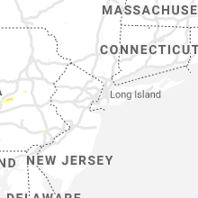
States Impacted
New Jersey, Wyoming, Virginia, Ohio, Georgia, Texas, Pennsylvania, Oregon, New Mexico, California, Kansas, MissouriNew Jersey
| Local Time | Report Details |
|---|---|
| 10:47 AM EDT | Cherry hill blvd is closed in all directions due to downed wires. time estimated from rada in camden county NJ, 76 miles SW of Brooklyn, NY |
| 10:47 PM EDT | Tree down on house; large limbs dow in camden county NJ, 76 miles SW of Brooklyn, NY |
| 10:47 PM EDT | Chapel ave between mercer st and murray ave closed due to downed wires. time estimated from rada in camden county NJ, 76 miles SW of Brooklyn, NY |
| 10:52 PM EDT | Trees and branches down all over knollwood area of cherry hill. report from social medi in camden county NJ, 76 miles SW of Brooklyn, NY |
| 10:52 PM EDT | Downed tree on nj 38 eastbound area of cherry hill mall (cherry hill twp) right and center lanes closed. time estimated from rada in camden county NJ, 75.2 miles SW of Brooklyn, NY |
| 10:52 PM EDT | Transformer fire off kings highway in cherry hill. power lines down. report from social medi in camden county NJ, 74.5 miles SW of Brooklyn, NY |
| 10:52 PM EDT | Power lines down on kingston... near kings highway and chapel ave. report from social media. time estimated from rada in camden county NJ, 75 miles SW of Brooklyn, NY |
Wyoming
| Local Time | Report Details |
|---|---|
| 10:25 AM MDT | Wind gust of 65 mph estimate in lincoln county WY, 81.7 miles WNW of Rock Springs, WY |
Virginia
| Local Time | Report Details |
|---|---|
| 1:21 PM EDT | Corrects previous tstm wnd dmg report from 2 nw ingalls field. a few trees down along sam snead highway... one at the intersection with ashwood drive... another fell on in bath county VA, 48.4 miles N of Roanoke, VA |
| 1:26 PM EDT | One tree reported down in front of the country convenience store on fries road. time estimated from rada in carroll county VA, 68 miles SW of Roanoke, VA |
| 1:29 PM EDT | Three trees down along spruce run road near newport. time estimated from rada in giles county VA, 31.4 miles W of Roanoke, VA |
| 1:40 PM EDT | Tree down across meadowbrook drive near intersection with glade road. time estimated from rada in montgomery county VA, 29.3 miles W of Roanoke, VA |
| 2:00 PM EDT | Golf Ball sized hail reported near Salem, VA, 6.9 miles WNW of Roanoke, VA, image shared on social media of golf ball hail next to measuring stick. time estimated from radar. |
| 2:19 PM EDT | Quarter sized hail reported near Salem, VA, 6.9 miles WNW of Roanoke, VA |
| 2:30 PM EDT | Tree down along north lee highway just north of its intersection with interstate 81. time estimated from rada in rockbridge county VA, 50.5 miles NE of Roanoke, VA |
| 2:38 PM EDT | Tree fell onto utility lines in the 2500 block of avenham avenue and got tangled. time estimated from rada in city of roanoke county VA, 1.6 miles SSW of Roanoke, VA |
| 2:41 PM EDT | Tree down at the intersection of garden city boulevard se and bandy road. time estimated from rada in city of roanoke county VA, 2.4 miles SSE of Roanoke, VA |
| 2:47 PM EDT | Quarter sized hail reported near Hiwassee, VA, 45.7 miles WSW of Roanoke, VA, images of quarter size hail shared on social media. |
| 2:59 PM EDT | Downed tree on power lines around the new hope are in augusta county VA, 71.6 miles SE of Elkins, WV |
| 4:34 PM EDT | Downed trees near the 1200 block of lee hwy... and between lee hwy and rt 231 in rappahannock county VA, 85.8 miles NNW of Richmond, VA |
| 4:42 PM EDT | Downed tree near the 200 block of castleton ford rd in rappahannock county VA, 79.5 miles NNW of Richmond, VA |
| 4:50 PM EDT | Multiple trees down in the 10000 block of homeland road in culpeper county VA, 79.5 miles NNW of Richmond, VA |
| 4:50 PM EDT | Tree down on va-729 richmond road near aaron mountain roa in rappahannock county VA, 83.8 miles NNW of Richmond, VA |
| 5:30 PM EDT | Quarter sized hail reported near Galax, VA, 71.2 miles E of Bristol, TN, retired nws employee. reported that hail fell for about 20 minutes. the hail started out as the size of dimes and then became as large as quarters. only hail initially |
| 5:35 PM EDT | Quarter sized hail reported near Galax, VA, 71.2 miles E of Bristol, TN, corrects previous hail report from 4 ssw galax city. retired nws employee. reported that hail fell for about 20 minutes. the hail started out as the size of dimes and t |
Ohio
| Local Time | Report Details |
|---|---|
| 5:56 PM EDT | Several trees down in guernsey county OH, 79.2 miles WSW of Pittsburgh, PA |
| 6:22 PM EDT | Trees and power lines down in columbiana county OH, 35.3 miles WNW of Pittsburgh, PA |
| 6:27 PM EDT | Several trees down in monroe county OH, 71.1 miles SW of Pittsburgh, PA |
| 7:00 PM EDT | Several trees down in monroe county OH, 73.1 miles SW of Pittsburgh, PA |
Georgia
| Local Time | Report Details |
|---|---|
| 6:32 PM EDT | Tree downed near the intersection of posey rd and hwy 3 in coweta county GA, 29 miles SW of Atlanta, GA |
Texas
| Local Time | Report Details |
|---|---|
| 5:56 PM CDT | Ping Pong Ball sized hail reported near Booker, TX, 64.2 miles W of Woodward, OK |
| 6:38 PM CDT | Reported by west texas mesonet station in briscoe county TX, 48.5 miles W of Childress, TX |
| 6:52 PM CDT | A large tree branch 4 to 6 inches in diameter was blown down. in addition... the roof was blown off a barn. this damage occurred in the southwest part of miam in roberts county TX, 75.1 miles ENE of Amarillo, TX |
| 7:00 PM CDT | Measured by west texas mesonet station. sutained wind speeds of 50-55 mph along with 5 minutes of gusts at or above 60 mp in lamb county TX, 57.7 miles NW of Lubbock, TX |
| 7:37 PM CDT | Broken power pole south side of town along farm-to-market 3215 in castro county TX, 54.2 miles SSW of Amarillo, TX |
Pennsylvania
| Local Time | Report Details |
|---|---|
| 7:00 PM EDT | Various reports of trees and wires down in westmoreland county PA, 15.7 miles E of Pittsburgh, PA |
| 7:00 PM EDT | Quarter sized hail reported near Oakdale, PA, 10.5 miles WSW of Pittsburgh, PA, quarter size hail |
| 7:05 PM EDT | *** 6 inj *** wind blew tent which hit peopl in westmoreland county PA, 15.7 miles E of Pittsburgh, PA |
| 7:15 PM EDT | Ping Pong Ball sized hail reported near Mc Donald, PA, 9.3 miles SW of Pittsburgh, PA, ping pong ball size hail |
| 7:16 PM EDT | Quarter sized hail reported near Bridgeville, PA, 8 miles SW of Pittsburgh, PA, quarter size hail |
| 7:16 PM EDT | Quarter sized hail reported near Bridgeville, PA, 9.7 miles SW of Pittsburgh, PA |
| 7:19 PM EDT | Quarter sized hail reported near Pittsburgh, PA, 8.1 miles SSW of Pittsburgh, PA, quarter size hail |
| 7:20 PM EDT | Numerous reports of trees and wires dow in allegheny county PA, 8.5 miles SSW of Pittsburgh, PA |
| 7:25 PM EDT | A dozen trees down in east hanover twp between trail road and sr 743. wires down on trail rd and south meadow ln. mature maple tree snappe in dauphin county PA, 69.7 miles ESE of State College, PA |
| 7:40 PM EDT | Multiple trees down in north londonderry tw in lebanon county PA, 69.7 miles N of Baltimore, MD |
Oregon
| Local Time | Report Details |
|---|---|
| 4:09 PM PDT | Nws storm survey found straight-line wind damage of approximately 45 to 55 mph winds near halsey and ne 75th and near tillamook and ne 78th. in addition similar straigh in multnomah county OR, 3.9 miles ENE of Portland, OR |
New Mexico
| Local Time | Report Details |
|---|---|
| 6:10 PM MDT | Quarter sized hail reported near Hobbs, NM, 78.3 miles NW of Odessa, TX |
| 6:13 PM MDT | Quarter sized hail reported near Hobbs, NM, 77.2 miles NW of Odessa, TX |
| 6:15 PM MDT | Hen Egg sized hail reported near Hobbs, NM, 76.8 miles NW of Odessa, TX |
| 6:16 PM MDT | Ping Pong Ball sized hail reported near Hobbs, NM, 79.4 miles NW of Odessa, TX |
| 10:12 PM MDT | Quarter sized hail reported near Carlsbad, NM, 70.5 miles SSE of Roswell, NM |
| 10:12 PM MDT | Quarter sized hail reported near Carlsbad, NM, 73.2 miles SSE of Roswell, NM |
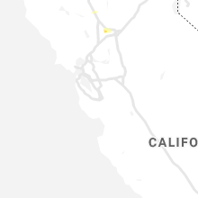
California
| Local Time | Report Details |
|---|---|
| 6:25 PM PDT | Quarter sized hail reported near Woodland, CA, 27.5 miles W of Citrus Heights, CA, spotter so47 located on highway 113 north of davis. |
Kansas
| Local Time | Report Details |
|---|---|
| 8:42 PM CDT | Severe thunderstorm wind gusts damaged 9 outbuildings on the south side of mulberr in crawford county KS, 46.4 miles E of Chanute, KS |
Missouri
| Local Time | Report Details |
|---|---|
| 9:07 PM CDT | Quarter sized hail reported near Lamar, MO, 58.4 miles E of Chanute, KS, time estimated from radar. |
| 9:25 PM CDT | Quarter sized hail reported near Lamar, MO, 59.3 miles WNW of Springfield, MO, time estimated from radar. |
Connect with Interactive Hail Maps