

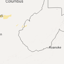
Hail Map for Monday, September 4, 2017

Number of Impacted Households on 9/4/2017
0
Impacted by 1" or Larger Hail
0
Impacted by 1.75" or Larger Hail
0
Impacted by 2.5" or Larger Hail
Square Miles of Populated Area Impacted on 9/4/2017
0
Impacted by 1" or Larger Hail
0
Impacted by 1.75" or Larger Hail
0
Impacted by 2.5" or Larger Hail

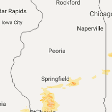


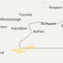


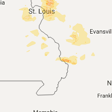


Cities Most Affected by Hail Storms of 9/4/2017
| Hail Size | Demographics of Zip Codes Affected | ||||||
|---|---|---|---|---|---|---|---|
| City | Count | Average | Largest | Pop Density | House Value | Income | Age |
| South Lyon, MI | 1 | 2.00 | 2.00 | 605 | $201k | $67.5k | 40.8 |
| Bunker Hill, IL | 1 | 2.00 | 2.00 | 61 | $73k | $44.8k | 41.9 |
| Nevis, MN | 1 | 1.75 | 1.75 | 22 | $124k | $37.3k | 52.1 |
| Carlinville, IL | 1 | 1.75 | 1.75 | 46 | $77k | $36.9k | 40.5 |
Hail and Wind Damage Spotted on 9/4/2017
Filter by Report Type:Hail ReportsWind Reports
States Impacted
Minnesota, Michigan, Illinois, Ohio, Indiana, Missouri, New York, Pennsylvania, KentuckyMinnesota
| Local Time | Report Details |
|---|---|
| 12:10 PM CDT | Quarter sized hail reported near Park Rapids, MN, 33.6 miles S of Bemidji, MN, vegabond village campground |
| 12:20 PM CDT | Quarter sized hail reported near Nevis, MN, 38.2 miles S of Bemidji, MN, big stony lake. via social media |
| 12:20 PM CDT | Golf Ball sized hail reported near Nevis, MN, 35.6 miles S of Bemidji, MN, sheriff department report. |
| 1:35 PM CDT | Quarter sized hail reported near East Grand Forks, MN, 73.7 miles N of Fargo, ND |
| 1:50 PM CDT | Quarter sized hail reported near Puposky, MN, 14.4 miles N of Bemidji, MN, mostly dimes and nickels... but a few quarter size hail. |
| 3:33 PM CDT | Peak wind measured at the detroit lakes airpor in becker county MN, 43 miles E of Fargo, ND |
| 4:30 PM CDT | Boats capsized on lake minnetonka. no reports of injuries. time estimate in hennepin county MN, 14.7 miles W of Minneapolis, MN |
| 5:35 PM CDT | A large tree over 6 inches in diameter was knocked ove in waseca county MN, 63.3 miles SSW of Minneapolis, MN |
| 5:55 PM CDT | Power poles down across owatonn in steele county MN, 61.4 miles S of Minneapolis, MN |
| 5:55 PM CDT | Trees of 10 to 24 inches in diameter uprooted at the brooktree golf cours in steele county MN, 60.8 miles S of Minneapolis, MN |
Michigan
| Local Time | Report Details |
|---|---|
| 5:30 PM EDT | Quarter sized hail reported near Whitmore Lake, MI, 41.6 miles SSW of Flint, MI |
| 5:30 PM EDT | Half Dollar sized hail reported near Whitmore Lake, MI, 41.5 miles S of Flint, MI, received photo verifying half dollar sized hail |
| 5:30 PM EDT | Report of power pole blown over and 3 inch tree limbs down in oakland county MI, 31.8 miles SSE of Flint, MI |
| 5:35 PM EDT | Quarter sized hail reported near South Lyon, MI, 39.4 miles S of Flint, MI |
| 5:37 PM EDT | Hen Egg sized hail reported near South Lyon, MI, 39.4 miles S of Flint, MI, verified via photo of 2 inch size hail |
| 6:50 PM EDT | Quarter sized hail reported near Blissfield, MI, 79 miles NE of Fort Wayne, IN, dime to quarter size hail reported |
Illinois
| Local Time | Report Details |
|---|---|
| 4:40 PM CDT | Quarter sized hail reported near Springfield, IL, 67.7 miles WNW of Mattoon, IL, at lake springfield. relayed by sangamon co. ema |
| 5:14 PM CDT | Ping Pong Ball sized hail reported near Carlinville, IL, 52.7 miles NNE of Saint Louis, MO, report via ham radio |
| 5:26 PM CDT | Quarter sized hail reported near Mt Zion, IL, 33.9 miles NW of Mattoon, IL, time estimated by radar |
| 5:26 PM CDT | Half Dollar sized hail reported near Mt Zion, IL, 33.9 miles NW of Mattoon, IL, time estimated |
| 5:28 PM CDT | Quarter sized hail reported near Decatur, IL, 33.5 miles NW of Mattoon, IL, time estimated by radar |
| 5:45 PM CDT | Golf Ball sized hail reported near Carlinville, IL, 42.8 miles NNE of Saint Louis, MO, observed at beaver dam state park |
| 6:15 PM CDT | Storm damage reported in montgomery county IL, 47.9 miles NE of Saint Louis, MO |
| 6:33 PM CDT | Hen Egg sized hail reported near Bunker Hill, IL, 32.4 miles NNE of Saint Louis, MO |
| 7:05 PM CDT | Debris blown from front of the store and carts blown across parking lot and flipped in madison county IL, 17.3 miles NNE of Saint Louis, MO |
| 7:12 PM CDT | Power lines down in the city in st. clair county IL, 21.2 miles E of Saint Louis, MO |
| 7:47 PM CDT | Two trees blocking road in the city. em estimated 50 mph wind in clinton county IL, 28.1 miles E of Saint Louis, MO |
| 10:20 PM CDT | Quarter sized hail reported near Thompsonville, IL, 60.1 miles NE of Cape Girardeau, MO, viewer report relayed through wsil tv. |
| 5:25 AM CDT | Half Dollar sized hail reported near Olmsted, IL, 24.4 miles ESE of Cape Girardeau, MO |
Ohio
| Local Time | Report Details |
|---|---|
| 7:10 PM EDT | Multiple trees reported down through the north and west side of toled in lucas county OH, 90.4 miles ENE of Fort Wayne, IN |
| 7:10 PM EDT | Tree down on naomi dr. power lines down also in lucas county OH, 88.7 miles ENE of Fort Wayne, IN |
| 7:15 PM EDT | Medium sized tree limbs downed in rossfor in wood county OH, 88.1 miles ENE of Fort Wayne, IN |
| 7:15 PM EDT | Quarter sized hail reported near Toledo, OH, 88.7 miles S of Flint, MI |
| 7:26 PM EDT | Siding blown off house at detroit and phillips in lucas county OH, 88.7 miles ENE of Fort Wayne, IN |
| 7:38 PM EDT | Tree downed on a power line. no estimate on size/health of the tre in henry county OH, 62 miles ENE of Fort Wayne, IN |
| 7:43 PM EDT | Power line downed near hamler causing the csx crossing gate not to go down because it is getting caught in the line. csx crew and a deputy are on their way to look at i in henry county OH, 56.8 miles E of Fort Wayne, IN |
| 10:45 PM EDT | Possible tornado. numerous structures damaged and extensive tree and power line/pole damage from near north robinson east to the county line just north of crestlin in crawford county OH, 57.6 miles N of Columbus, OH |
| 10:52 PM EDT | Possible tornado. widespread damage reported along hook rd in richland county near the crawford county line. a barn was destroyed... a house collapsed... other structur in richland county OH, 61.7 miles NNE of Columbus, OH |
| 10:58 PM EDT | Quarter sized hail reported near Galion, OH, 54.2 miles NNE of Columbus, OH, quarter size hail |
Indiana
| Local Time | Report Details |
|---|---|
| 7:25 PM EDT | Tree reported across county road 1250w. relayed via twitter. time estimated by rada in howard county IN, 51.2 miles NNW of Indianapolis, IN |
| 9:40 PM EDT | Storm damage reported in randolph county IN, 56.3 miles ENE of Indianapolis, IN |
Missouri
| Local Time | Report Details |
|---|---|
| 7:00 PM CDT | Tree of unknown size downed power lines on henning roa in st. charles county MO, 29.2 miles WNW of Saint Louis, MO |
| 7:10 PM CDT | Tree of unknown size downed and overhanging another. debris in roadwa in st. charles county MO, 32 miles W of Saint Louis, MO |
New York
| Local Time | Report Details |
|---|---|
| 10:24 PM EDT | Trees dow in chautauqua county NY, 60 miles SW of Buffalo, NY |
| 10:26 PM EDT | Trees dow in chautauqua county NY, 36 miles SW of Buffalo, NY |
| 10:30 PM EDT | Trees down on rt 2 in chautauqua county NY, 52.9 miles SW of Buffalo, NY |
| 10:33 PM EDT | Tree on a hous in chautauqua county NY, 28.1 miles SSW of Buffalo, NY |
| 10:36 PM EDT | Wires down on beckwith r in genesee county NY, 29.3 miles ENE of Buffalo, NY |
| 10:40 PM EDT | Storm damage reported in chautauqua county NY, 40.7 miles SW of Buffalo, NY |
| 10:45 PM EDT | Storm damage reported in chautauqua county NY, 34.1 miles SW of Buffalo, NY |
| 10:51 PM EDT | Trees and wires down in chautauqua county NY, 42 miles SSW of Buffalo, NY |
| 10:54 PM EDT | Trees and wires down on rte 39 in cattaraugus county NY, 30 miles SSW of Buffalo, NY |
| 10:56 PM EDT | Trees down in cattaraugus county NY, 32.5 miles S of Buffalo, NY |
| 10:56 PM EDT | Multiple trees down in gowand in cattaraugus county NY, 29.5 miles S of Buffalo, NY |
| 11:08 PM EDT | Trees down in erie county NY, 25 miles SSE of Buffalo, NY |
| 11:10 PM EDT | Trees down in springville in erie county NY, 28 miles SSE of Buffalo, NY |
| 11:15 PM EDT | Trees down in chautauqua county NY, 58.7 miles SSW of Buffalo, NY |
| 11:17 PM EDT | Trees down in chautauqua county NY, 58 miles SSW of Buffalo, NY |
| 11:18 PM EDT | Multiple reports of trees/wires down around the city in chautauqua county NY, 57.3 miles SSW of Buffalo, NY |
| 11:19 PM EDT | Trees down in erie county NY, 31.2 miles SE of Buffalo, NY |
| 11:20 PM EDT | Tree dow in wyoming county NY, 33.5 miles SE of Buffalo, NY |
| 11:41 PM EDT | Trees down in chautauqua county NY, 61.9 miles SSW of Buffalo, NY |
| 11:45 PM EDT | Tree limbs down in cattaraugus county NY, 49.7 miles SSE of Buffalo, NY |
| 11:50 PM EDT | Wires down in ontario county NY, 52.4 miles W of Syracuse, NY |
| 11:55 PM EDT | Storm damage reported in ontario county NY, 52.9 miles W of Syracuse, NY |
| 11:58 PM EDT | Wires down in wayne county NY, 47.7 miles W of Syracuse, NY |
| 12:09 AM EDT | Trees down in cattaraugus county NY, 60.1 miles SSE of Buffalo, NY |
| 12:13 AM EDT | Trees down in cattaraugus county NY, 61.4 miles SSE of Buffalo, NY |
| 12:20 AM EDT | Trees/wires down in allegany county NY, 59.9 miles SE of Buffalo, NY |
| 12:22 AM EDT | Trees/wires down in oswego county NY, 23.8 miles NW of Syracuse, NY |
| 12:34 AM EDT | Trees/wires down in town of ward in allegany county NY, 67.8 miles SE of Buffalo, NY |
| 12:34 AM EDT | Multiple reports of trees/wires down around city in ontario county NY, 44 miles WSW of Syracuse, NY |
| 12:38 AM EDT | Trees/wires down in allegany county NY, 73.3 miles SE of Buffalo, NY |
Pennsylvania
| Local Time | Report Details |
|---|---|
| 12:05 AM EDT | Trees and wires dow in mckean county PA, 65 miles S of Buffalo, NY |
| 12:05 AM EDT | Trees and wires dow in mckean county PA, 63.7 miles S of Buffalo, NY |
| 12:18 AM EDT | Trees dow in warren county PA, 68 miles SSW of Buffalo, NY |
Kentucky
| Local Time | Report Details |
|---|---|
| 6:00 AM CDT | Quarter sized hail reported near Kevil, KY, 41.3 miles ESE of Cape Girardeau, MO |
Connect with Interactive Hail Maps