

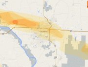
Hail Map for Western Suburbs of St. Louis, MO June 4th, 2012
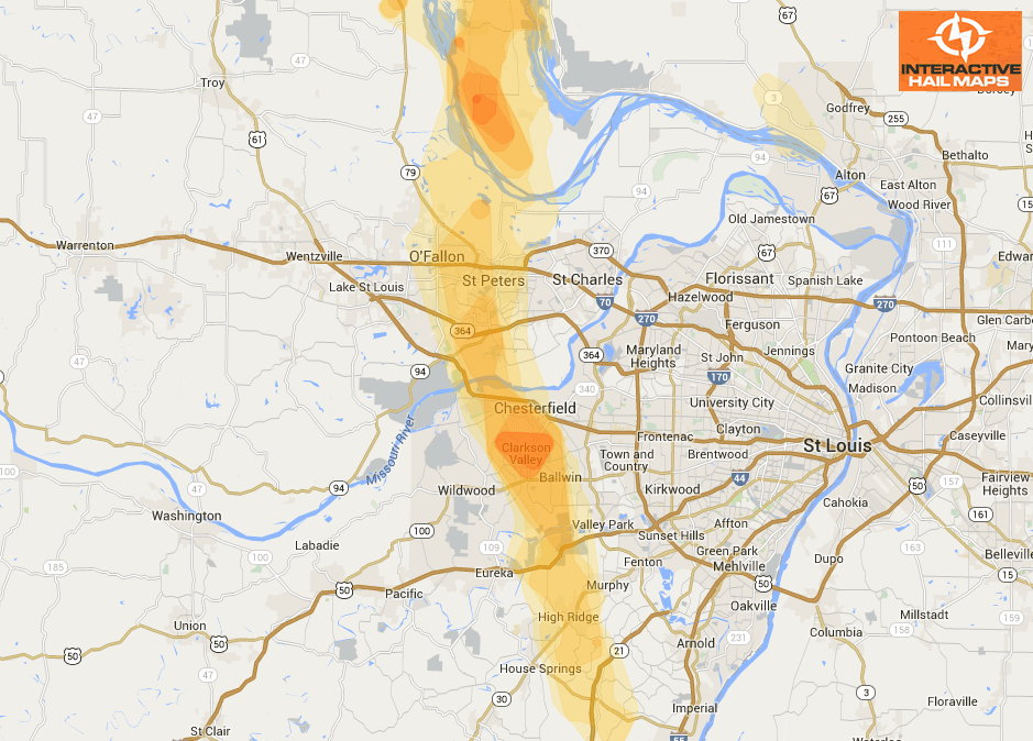
This hail maps shows the hail storms that clipped the western suburbs of St. Louis, MO, including St. Charles, St. Peters, and Chesterfield, MO. Use Interactive Hail Maps to find hail others have overlooked with street level accuracy.
Cities Most Affected by Hail Storms of 6/4/2012
| Hail Size | Demographics of Zip Codes Affected | ||||||
|---|---|---|---|---|---|---|---|
| City | Count | Average | Largest | Pop Density | House Value | Income | Age |
| Fort Stewart, GA | 2 | 2.25 | 2.75 | 926 | $138k | $30.7k | 20.1 |
| Hinesville, GA | 2 | 1.75 | 1.75 | 619 | $78k | $34.4k | 28.5 |
| Floweree, MT | 1 | 2.75 | 2.75 | 1 | $119k | $42.4k | 48.3 |
| Carter, MT | 1 | 2.00 | 2.00 | 0 | $70k | $20.6k | 41.8 |
| Benton, MO | 1 | 1.75 | 1.75 | 40 | $81k | $34.7k | 38.8 |
| Mershon, GA | 1 | 1.75 | 1.75 | 14 | $72k | $28.8k | 37.0 |
| Midway, GA | 1 | 1.75 | 1.75 | 79 | $99k | $34.0k | 40.6 |
| Ballwin, MO | 1 | 1.75 | 1.75 | 2599 | $148k | $66.6k | 39.3 |
| Weippe, ID | 1 | 1.75 | 1.75 | 5 | $65k | $28.9k | 50.5 |
| Power, MT | 1 | 1.75 | 1.75 | 2 | $73k | $36.6k | 45.3 |
| Greenville, MS | 1 | 1.75 | 1.75 | 313 | $61k | $26.5k | 35.2 |
| Chesterfield, MO | 1 | 1.75 | 1.75 | 542 | $370k | $126.5k | 42.7 |
| Fort Benton, MT | 1 | 1.75 | 1.75 | 0 | $74k | $30.3k | 51.0 |
| Donnelly, ID | 1 | 1.75 | 1.75 | 5 | $153k | $33.5k | 40.2 |
| Floydada, TX | 1 | 1.75 | 1.75 | 7 | $35k | $25.8k | 38.1 |
| Hamilton, MT | 1 | 1.75 | 1.75 | 27 | $128k | $28.1k | 47.9 |
| Conrad, MT | 1 | 1.75 | 1.75 | 6 | $72k | $31.6k | 45.6 |
Connect with Interactive Hail Maps