

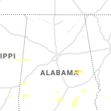
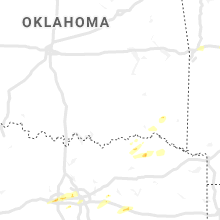
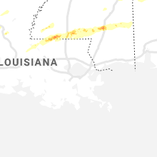
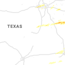
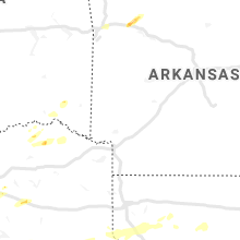
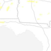
Hail Map for Sunday, April 19, 2020

Number of Impacted Households on 4/19/2020
0
Impacted by 1" or Larger Hail
0
Impacted by 1.75" or Larger Hail
0
Impacted by 2.5" or Larger Hail
Square Miles of Populated Area Impacted on 4/19/2020
0
Impacted by 1" or Larger Hail
0
Impacted by 1.75" or Larger Hail
0
Impacted by 2.5" or Larger Hail


Cities Most Affected by Hail Storms of 4/19/2020
| Hail Size | Demographics of Zip Codes Affected | ||||||
|---|---|---|---|---|---|---|---|
| City | Count | Average | Largest | Pop Density | House Value | Income | Age |
| Mc Gregor, TX | 2 | 1.75 | 1.75 | 94 | $58k | $39.8k | 38.2 |
| Lawrence, MS | 1 | 2.00 | 2.00 | 19 | $50k | $33.0k | 40.4 |
| Paris, TX | 1 | 1.75 | 1.75 | 266 | $47k | $26.2k | 36.7 |
| Sumrall, MS | 1 | 1.75 | 1.75 | 47 | $66k | $30.9k | 35.2 |
| Alexander City, AL | 1 | 1.75 | 1.75 | 104 | $72k | $30.8k | 40.8 |
| Hattiesburg, MS | 1 | 1.75 | 1.75 | 485 | $113k | $41.2k | 33.4 |
| Katy, TX | 1 | 1.75 | 1.75 | 449 | $91k | $56.2k | 33.5 |
| Fort Worth, TX | 1 | 1.75 | 1.75 | 2616 | $78k | $35.4k | 37.8 |
| Palestine, TX | 1 | 1.75 | 1.75 | 49 | $0k | $0.0k | 38.2 |
Hail and Wind Damage Spotted on 4/19/2020
Filter by Report Type:Hail ReportsWind Reports
States Impacted
Alabama, Texas, Georgia, Louisiana, South Carolina, Arkansas, Oklahoma, Mississippi, Kansas, FloridaAlabama
| Local Time | Report Details |
|---|---|
| 7:00 AM CDT | Quarter sized hail reported near Goodwater, AL, 44.1 miles NW of Auburn, AL, social media photo of large hail accumulation south of goodwater. |
| 7:02 AM CDT | Widespread... rather significant tree damage and large hail reported in kellyto in coosa county AL, 41.4 miles NW of Auburn, AL |
| 7:02 AM CDT | Reports of widespread trees down... power lines down and first responders responding to entrapments. time and location approximat in tallapoosa county AL, 35.6 miles NW of Auburn, AL |
| 7:05 AM CDT | Numerous reports trees down & wind damage in wind creek state park. many rvs and campers were destroyed... mostly from fallen tree in tallapoosa county AL, 31.9 miles WNW of Auburn, AL |
| 7:06 AM CDT | Quarter sized hail reported near Alexander City, AL, 35.6 miles NW of Auburn, AL, quarter sized hail reported. power outages with possible tree limbs down. |
| 7:06 AM CDT | Golf Ball sized hail reported near Alexander City, AL, 35.6 miles NW of Auburn, AL, golf ball size hail in alex city. |
| 7:10 AM CDT | Trees down in jacksons ga in tallapoosa county AL, 27.2 miles NW of Auburn, AL |
| 7:20 AM CDT | *** 1 inj *** corrects time on previous tstm wnd dmg report from dadeville. widespread wind damage in dadeville. at least one reported minor injur in tallapoosa county AL, 22.8 miles NW of Auburn, AL |
| 7:35 AM CDT | Multiple reports of trees and power lines down. reports of cars toppled. phone service very spotty with limited cellular phone coverag in coosa county AL, 43.5 miles WNW of Auburn, AL |
| 7:42 AM CDT | Several reports of trees and power lines dow in chambers county AL, 20.7 miles NNE of Auburn, AL |
| 8:10 AM CDT | Large tree dow in shelby county AL, 20.2 miles S of Birmingham, AL |
| 11:37 AM CDT | *** 1 inj *** corrects previous tstm wnd dmg report from dadeville. widespread wind damage in dadeville. at least one reported minor injur in tallapoosa county AL, 22.8 miles NW of Auburn, AL |
| 5:18 PM CDT | Trees down across hwy 11 just east of york. time estimated by rada in sumter county AL, 68 miles WNW of Camden, AL |
| 5:18 PM CDT | Corrects time of previous tstm wnd dmg report from 3 n i-20 welcome center cuba. tree down on cr 27 near cr 2 in morningstar community. time estimated by rada in sumter county AL, 71.6 miles SSE of Starkville, MS |
| 6:18 PM CDT | Tree down on cr 27 near cr 2 in morningstar community. time estimated by rada in sumter county AL, 71.6 miles SSE of Starkville, MS |
| 7:30 PM CDT | Trees down all across the count in butler county AL, 40.4 miles ESE of Camden, AL |
| 8:01 PM CDT | Reports of trees down near highland home and lapin in crenshaw county AL, 57 miles E of Camden, AL |
| 9:17 PM CDT | Trees down on hwy 17 just south of tibbi in washington county AL, 46.7 miles NNW of Mobile, AL |
| 9:47 PM CDT | Roof damage to a local restaurant. picture via social medi in monroe county AL, 36.2 miles S of Camden, AL |
| 10:11 PM CDT | Local radio station reported trees down i-65 near the owassa communit in conecuh county AL, 39.8 miles SSE of Camden, AL |
| 10:14 PM CDT | Numerous trees and powerlines reported down county-wid in coffee county AL, 73.4 miles NNE of Miramar Beach, FL |
| 10:15 PM CDT | Numerous trees and powerlines down county-wid in coffee county AL, 74.2 miles NNE of Miramar Beach, FL |
| 10:41 PM CDT | Numerous trees down west and southwest of rutledg in crenshaw county AL, 58.8 miles ESE of Camden, AL |
| 10:42 PM CDT | Tree through a house and numerous tress down in the gantt communit in covington county AL, 62.4 miles SE of Camden, AL |
| 10:42 PM CDT | Numerous trees down across luverne and rutledge (and county-wide in crenshaw county AL, 63.5 miles ESE of Camden, AL |
| 10:43 PM CDT | Multiple trees down near andalusi in covington county AL, 65.4 miles N of Miramar Beach, FL |
| 10:43 PM CDT | Several trees down in the petrey and patsburg communitie in crenshaw county AL, 64.6 miles ESE of Camden, AL |
| 10:44 PM CDT | Numerous trees down between brantley and luvern in crenshaw county AL, 62.9 miles ESE of Camden, AL |
| 10:44 PM CDT | Multiple trees down just north of dozie in crenshaw county AL, 64.6 miles ESE of Camden, AL |
| 10:49 PM CDT | Numerous trees down near glenwood (and between luverne and glenwood in crenshaw county AL, 69 miles ESE of Camden, AL |
| 10:54 PM CDT | Awos station k79j at the andalusia opp airport measured a wind gust of 60 mp in covington county AL, 65.1 miles N of Miramar Beach, FL |
| 10:55 PM CDT | Numerous trees down in the area with some roads blocke in pike county AL, 71.4 miles ESE of Camden, AL |
| 10:58 PM CDT | Trees down in opp. metal roof peeled off residenc in covington county AL, 62.7 miles N of Miramar Beach, FL |
| 11:02 PM CDT | Numerous trees & power lines down across the are in pike county AL, 69.2 miles SSW of Auburn, AL |
| 11:05 PM CDT | Roof blown off 1 building and few trees down in the downtown are in pike county AL, 62 miles SSW of Auburn, AL |
| 11:05 PM CDT | Trees down on troy university campu in pike county AL, 62.3 miles SSW of Auburn, AL |
| 11:05 PM CDT | Photos from social media show roof off of a house off cr 220 near victori in coffee county AL, 79.6 miles SSW of Auburn, AL |
| 11:07 PM CDT | Trees and power lines down. fence blown dow in mobile county AL, 12.1 miles WSW of Mobile, AL |
| 11:07 PM CDT | Trees and power lines down. tree damaged a boat trailer. limbs and leaf debris noted all along mcfarland rd/snow rd area. similar damage in the spring grove neighborhoo in mobile county AL, 12.6 miles WSW of Mobile, AL |
| 11:10 PM CDT | Trees and powerlines down cr460 outside of kinston. barns and homes heavily damage in coffee county AL, 60.4 miles NNE of Miramar Beach, FL |
| 11:15 PM CDT | Numerous trees & power lines down in the area. roof torn off 1 mobile hom in pike county AL, 64.3 miles SSW of Auburn, AL |
| 11:17 PM CDT | Multiple trees down throughout dale county and 2 reports of trees on house in dale county AL, 79.3 miles S of Auburn, AL |
| 11:17 PM CDT | Several trees down and damage to a residenc in baldwin county AL, 11.5 miles E of Mobile, AL |
| 11:21 PM CDT | Gazebo destroyed. trees down in the irvington area. reports and pictures via social medi in mobile county AL, 16.1 miles SW of Mobile, AL |
| 11:22 PM CDT | Damage to brick facade of the recreational center buildin in dale county AL, 80.3 miles S of Auburn, AL |
| 11:23 PM CDT | Trees down across north and southbound lanes of highway 231 near the loves travel sto in dale county AL, 81.5 miles S of Auburn, AL |
| 11:25 PM CDT | Tree on house in the 700 block of brundidge st. everyone is out and saf in barbour county AL, 62.4 miles S of Auburn, AL |
| 11:26 PM CDT | Multiple trees down. tree on residenc in baldwin county AL, 9.7 miles ESE of Mobile, AL |
| 11:27 PM CDT | Trees down in the area with some roads blocke in barbour county AL, 62.3 miles S of Auburn, AL |
| 11:32 PM CDT | Trees down on hwy 10 at dale cr 10 in barbour county AL, 67.4 miles S of Auburn, AL |
| 11:33 PM CDT | Usa chili mesonet site in loxley measured winds of 74 mp in baldwin county AL, 19.5 miles E of Mobile, AL |
| 11:40 PM CDT | Multiple trees down in the 3300 block of cr 5 in barbour county AL, 65.3 miles S of Auburn, AL |
| 11:40 PM CDT | Trees down blocking hwy 131 between bud gary rd and cr 5 in barbour county AL, 60.7 miles S of Auburn, AL |
| 11:43 PM CDT | Numerous trees down across huxford. trampoline tossed. pictures and reports via social medi in escambia county AL, 50.5 miles NE of Mobile, AL |
| 11:45 PM CDT | Report of a camper overturned. trees down. pictures and videos via social medi in baldwin county AL, 29.7 miles ESE of Mobile, AL |
| 11:50 PM CDT | Numerous tress down along hwy 431 in the southern part of the count in barbour county AL, 60.5 miles SSE of Auburn, AL |
| 11:52 PM CDT | Trees down in the robindale subdivisio in houston county AL, 77.7 miles NE of Miramar Beach, FL |
| 11:55 PM CDT | Trees and power lines down on bulloch circl in barbour county AL, 52.5 miles SSE of Auburn, AL |
| 12:32 AM CDT | 60 mph winds estimated by ham radio operator in coden... a in mobile county AL, 23.9 miles SSW of Mobile, AL |
Texas
| Local Time | Report Details |
|---|---|
| 7:52 AM CDT | Quarter sized hail reported near Mc Gregor, TX, 30.4 miles NE of Killeen, TX |
| 7:55 AM CDT | Golf Ball sized hail reported near Mc Gregor, TX, 36 miles NE of Killeen, TX, multiple reports of golf ball hail along highway 84 near woodway. |
| 7:57 AM CDT | Golf Ball sized hail reported near Mc Gregor, TX, 36 miles NE of Killeen, TX, social media picture from hwy 84 and speegleville rd near twin rivers subdivision. time estimated by radar. |
| 9:22 AM CDT | Quarter sized hail reported near Houston, TX, 20.1 miles WNW of Houston, TX |
| 9:23 AM CDT | Quarter sized hail reported near Katy, TX, 29 miles W of Houston, TX, photo on social media of hail off cane island parkway... north of us 90. most hail was pea to nickel size... but a few matched the width of the 1 inch wide stripe on re |
| 9:25 AM CDT | Golf Ball sized hail reported near Katy, TX, 27.2 miles WNW of Houston, TX, golf ball sized hail reported at waller harris county esd 200 fire station. |
| 9:29 AM CDT | Quarter sized hail reported near Oakwood, TX, 74.2 miles WNW of Lufkin, TX, quarter hail in butler. |
| 9:35 AM CDT | Ping Pong Ball sized hail reported near Houston, TX, 20.4 miles WNW of Houston, TX, reported via social media. |
| 9:40 AM CDT | Ping Pong Ball sized hail reported near Katy, TX, 21 miles WNW of Houston, TX, photo of hail shared by broadcast media. time estimated by radar. |
| 9:40 AM CDT | Quarter sized hail reported near Houston, TX, 18.7 miles WNW of Houston, TX, photos sent of quarter/shooter marble sized hail via social media. location near highway 6 and fm 529. time reported by observer and supported by radar and other report |
| 9:42 AM CDT | Quarter sized hail reported near Houston, TX, 19.6 miles WNW of Houston, TX, report from mping: quarter (1.00 in.). |
| 9:48 AM CDT | Ping Pong Ball sized hail reported near Houston, TX, 19 miles WNW of Houston, TX |
| 9:58 AM CDT | Golf Ball sized hail reported near Palestine, TX, 65.9 miles WNW of Lufkin, TX, golf ball size hail at fm 645 and acr 2908. |
| 10:11 AM CDT | Quarter sized hail reported near Palestine, TX, 62.7 miles WNW of Lufkin, TX, quarter hail southwest of palestine. |
| 10:16 AM CDT | Golf Ball sized hail reported near Fort Worth, TX, 34.8 miles W of Dallas, TX, social media pictures of golf ball hail near i-30 and hulen st. |
| 10:17 AM CDT | Half Dollar sized hail reported near Grand Prairie, TX, 18.8 miles SW of Dallas, TX, reported near joe pool lake and lake ridge. |
| 10:33 AM CDT | Quarter sized hail reported near Arlington, TX, 17.2 miles W of Dallas, TX, report from mping: quarter (1.00 in.). |
| 10:36 AM CDT | Quarter sized hail reported near Arlington, TX, 19.5 miles W of Dallas, TX, social media report of quarter hail at i-30 and fielder. |
| 10:40 AM CDT | Half Dollar sized hail reported near Euless, TX, 17.5 miles WNW of Dallas, TX, quarter to slightly larger at hwy 10 and euless main. |
| 10:42 AM CDT | Ping Pong Ball sized hail reported near Irving, TX, 9.7 miles W of Dallas, TX, ping pong ball size hail at shady grove and macarthur. |
| 10:45 AM CDT | Large tree blocking the road 5 miles east of alto on hwy 2 in cherokee county TX, 27.1 miles NW of Lufkin, TX |
| 10:50 AM CDT | Corrects previous tstm wnd dmg report from 5 wsw cushing. trees down on fm 164 in nacogdoches county TX, 32.2 miles NNW of Lufkin, TX |
| 11:00 AM CDT | Ping Pong Ball sized hail reported near Cushing, TX, 29.4 miles NNW of Lufkin, TX, ping pong sized hail reported in lilbert. |
| 11:05 AM CDT | Ping Pong Ball sized hail reported near Terrell, TX, 30.5 miles E of Dallas, TX |
| 11:13 AM CDT | Corrects previous tstm wnd dmg report from 4 n appleby. tree down on cr13 in nacogdoches county TX, 30.3 miles NNE of Lufkin, TX |
| 11:16 AM CDT | Trees down on fm22 in nacogdoches county TX, 16.4 miles N of Lufkin, TX |
| 11:20 AM CDT | Trees down on fm 164 in nacogdoches county TX, 32.2 miles NNW of Lufkin, TX |
| 11:30 AM CDT | Photos and multiple social media reports of downed branches/trees... power lines... and a destroyed traffic signal within a few blocks of cleveland high school. time es in liberty county TX, 43.8 miles NNE of Houston, TX |
| 11:35 AM CDT | Quarter sized hail reported near Montalba, TX, 71.4 miles WNW of Lufkin, TX |
| 12:23 PM CDT | Quarter sized hail reported near Canton, TX, 56 miles ESE of Dallas, TX, report from mping: quarter (1.00 in.). |
| 1:00 PM CDT | Trees down on county road 45 in smith county TX, 81.4 miles E of Dallas, TX |
| 1:00 PM CDT | Trees down on hwy 45 in smith county TX, 73.6 miles E of Dallas, TX |
| 1:15 PM CDT | Tree down on cr13 in nacogdoches county TX, 30.3 miles NNE of Lufkin, TX |
| 1:15 PM CDT | Ping Pong Ball sized hail reported near Woodville, TX, 42.7 miles SSE of Lufkin, TX, tyler sheriffs department received a report of ping pong sized hail along 190 west... west of woodville. |
| 2:10 PM CDT | Photos submitted of possible tornado damage. time estimated from rada in brazoria county TX, 48.5 miles SSW of Houston, TX |
| 2:30 PM CDT | Golf Ball sized hail reported near Paris, TX, 57.9 miles SSE of Atoka, OK, report relayed through social media. |
| 2:40 PM CDT | Quarter sized hail reported near Paris, TX, 56.7 miles SE of Atoka, OK, the hail also shredded tree leaves. |
| 3:00 PM CDT | Tree down near pollo in angelina county TX, 11.6 miles NW of Lufkin, TX |
| 3:40 PM CDT | 1 tree down near broaddu in san augustine county TX, 26.1 miles E of Lufkin, TX |
| 4:12 PM CDT | Quarter sized hail reported near Clarksville, TX, 73.4 miles WSW of Nashville, AR, txdot reports hail dime to quarter size. |
| 4:15 PM CDT | Large tree down across hwy 18 in sabine county TX, 50.8 miles E of Lufkin, TX |
| 4:19 PM CDT | Volunteer firefighter reports probable tornado damage at various locations near tarkington prairie/macedonia. time estimated from rada in liberty county TX, 42.3 miles NE of Houston, TX |
| 4:21 PM CDT | Volunteer firefighter reports probable tornado damage at various locations near tarkington prairie/macedonia. time estimated from rada in liberty county TX, 44.9 miles NE of Houston, TX |
| 4:24 PM CDT | Volunteer firefighter reports probable tornado damage at various locations near tarkington prairie/macedonia. time estimated from rada in liberty county TX, 45.9 miles NE of Houston, TX |
| 4:37 PM CDT | Em reports measured 63 mph wind gust at wildwood security gat in hardin county TX, 51.3 miles NW of Beaumont, TX |
Georgia
| Local Time | Report Details |
|---|---|
| 11:10 AM EDT | Several large pecan trees were downed on highway 329 east of montezum in macon county GA, 85.2 miles NW of Douglas, GA |
| 11:27 AM EDT | Numerous trees snapped or uprooted along elko road... just south of sr 26. possible brief tornado. time estimated from rada in houston county GA, 75.4 miles NW of Douglas, GA |
| 11:28 AM EDT | Truck trailer blown over along with damage to several service station signs just off the interstate near unadilla. time estimated from rada in dooly county GA, 74.2 miles NW of Douglas, GA |
| 11:40 AM EDT | Reports of trees on homes in the city of hawkinsvill in pulaski county GA, 65 miles NW of Douglas, GA |
| 11:40 AM EDT | Several trees down around a home near the hwy 26 and brookwood drive are in pulaski county GA, 66.2 miles NW of Douglas, GA |
| 11:40 AM EDT | Several trees were downed on valleywood trai in pulaski county GA, 65.9 miles NW of Douglas, GA |
| 11:40 AM EDT | Roof damage... shed destroyed... and three trees downed off of pinelevel dr in hawkinsville. a whirring sound was also reporte in pulaski county GA, 64.4 miles NW of Douglas, GA |
| 11:50 AM EDT | Tree down across antioch baptist church road and friendship church road in dodge county GA, 59.2 miles NNW of Douglas, GA |
| 11:52 AM EDT | Tree down across powerlines on gresston baptist road in dodge county GA, 58.2 miles NNW of Douglas, GA |
| 12:15 PM EDT | Tree down on east gaines stree in laurens county GA, 71.3 miles N of Douglas, GA |
| 1:18 PM EDT | A small tree was reported down at sunbury road and old highway 25 in evans county GA, 44 miles W of Savannah, GA |
| 6:36 PM EDT | Quarter sized hail reported near Valdosta, GA, 42.6 miles SSW of Douglas, GA, penny to quarter size hail reported at moody air force base. |
| 1:05 AM EDT | Scattered trees down across early count in early county GA, 75.1 miles NNW of Tallahassee, FL |
| 1:10 AM EDT | Scattered trees down across randolph count in randolph county GA, 69.6 miles SE of Auburn, AL |
| 1:25 AM EDT | A few trees were downed along macedonia church r in webster county GA, 67.1 miles SE of Auburn, AL |
| 1:28 AM EDT | A few trees were downed along ben williams r in webster county GA, 69.1 miles SE of Auburn, AL |
| 1:30 AM EDT | Tree down across highway 118 blocking traffi in terrell county GA, 83.9 miles SE of Auburn, AL |
| 1:34 AM EDT | Trees down in southern miller count in miller county GA, 51.6 miles NNW of Tallahassee, FL |
| 1:55 AM EDT | Trees down in northern decatur count in decatur county GA, 45 miles NNW of Tallahassee, FL |
| 2:11 AM EDT | Tree down highway 133 and highway 112 blocking both lanes of traffi in worth county GA, 65.3 miles W of Douglas, GA |
| 2:12 AM EDT | Home completely destroyed on south county line roa in worth county GA, 67.6 miles W of Douglas, GA |
| 2:13 AM EDT | Major damage to a home on gates roa in worth county GA, 64.5 miles W of Douglas, GA |
| 2:17 AM EDT | Major home damage with entrapment on york roa in worth county GA, 60.4 miles W of Douglas, GA |
| 2:20 AM EDT | Corrects previous tstm wnd dmg report from 1 nw livingston. trees and powerlines down blocking highway 133 from highway 112 to worthwoo in worth county GA, 65.3 miles W of Douglas, GA |
| 2:20 AM EDT | Corrects previous tstm wnd dmg report from 1 nw livingston. trees and powerlines down blocking highway 133 from highway 112 to worthwoo in worth county GA, 65.3 miles W of Douglas, GA |
| 3:27 AM EDT | Tree down... power pole and lines down around area of raybon rd w of hwy 30 in brantley county GA, 50.5 miles ESE of Douglas, GA |
| 3:33 AM EDT | Tree down across hwy 32 in hortens in brantley county GA, 54.5 miles ESE of Douglas, GA |
| 4:24 AM EDT | Quarter sized hail reported near Ludowici, GA, 45.9 miles SW of Savannah, GA, dime to quarter size hail was reported in ludowici. |
| 4:28 AM EDT | A picture on social media shows a tree blocking part of hwy 19 in long county GA, 43.6 miles WSW of Savannah, GA |
Louisiana
| Local Time | Report Details |
|---|---|
| 10:55 AM CDT | Tree down on hwy 17 in de soto county LA, 24.5 miles SSW of Shreveport, LA |
| 11:58 AM CDT | Trees and power lines down on hwy 172 in keatchi in de soto county LA, 24.3 miles SSW of Shreveport, LA |
| 12:30 PM CDT | Trees reported down all over northern sabine parish and near convers in sabine county LA, 50.7 miles S of Shreveport, LA |
| 12:44 PM CDT | Tree down on hwy 786 near evans roa in red river county LA, 39.5 miles SE of Shreveport, LA |
| 1:22 PM CDT | 1 tree down over highway 153 near cresto in natchitoches county LA, 55 miles SE of Shreveport, LA |
| 1:26 PM CDT | Tree down and power lines down in the flora communit in natchitoches county LA, 72.4 miles SSE of Shreveport, LA |
| 1:26 PM CDT | Trees snapped on highway 120 in flora... l in natchitoches county LA, 73.3 miles SSE of Shreveport, LA |
| 1:45 PM CDT | Trees and power poles down on hwy 478 near flor in natchitoches county LA, 71.8 miles SSE of Shreveport, LA |
| 2:20 PM CDT | Trees down in kisatchie forest on forest service road 131... possible tornad in grant county LA, 82.4 miles SSW of Bastrop, LA |
| 4:20 PM CDT | Tree down on 2100 block of hwy 15 in natchitoches county LA, 45.6 miles SE of Shreveport, LA |
| 5:04 PM CDT | Slagle mall posted photo of uprooted and snapped trees to social medi in vernon county LA, 84.4 miles NNE of Beaumont, TX |
| 5:05 PM CDT | Trees uprooted and roof blown off hous in vernon county LA, 79.9 miles NNE of Beaumont, TX |
| 5:10 PM CDT | Numerous trees dow in grant county LA, 90.1 miles SSW of Bastrop, LA |
| 5:20 PM CDT | Numerous trees dow in grant county LA, 90.8 miles SSW of Bastrop, LA |
| 5:21 PM CDT | Emergency manager reported a tree blocking roadway in west feliciana parish on hwy 967 near 42 in west feliciana county LA, 59.9 miles NE of Lafayette, LA |
| 5:27 PM CDT | Trees and power lines reported down in jen in la salle county LA, 76 miles S of Bastrop, LA |
| 10:10 PM CDT | Fence blown down from east to west on cayman cove near n causeway and monroe in mandeville. fence post snapped off of a concrete base. large tree limbs down. possible t in st. tammany county LA, 28.7 miles N of New Orleans, LA |
| 10:11 PM CDT | Trees down in the vicinity of old mandeville. streets affected are monroe st to messina st to galvez and park st. time estimated by radar. possible tornado damag in st. tammany county LA, 28.7 miles N of New Orleans, LA |
| 10:20 PM CDT | Tree blown down damaging a fence near nancy and soult street. power outage occurred in the 2300 block of soult street and surrounding area in mandevill in st. tammany county LA, 28.7 miles N of New Orleans, LA |
| 10:20 PM CDT | Tree blown down damaging a fence near nancy and soult street. power outage occurred in the 2300 block of soult street and surrounding area in slidel in st. tammany county LA, 28.7 miles NE of New Orleans, LA |
South Carolina
| Local Time | Report Details |
|---|---|
| 12:13 PM EDT | A tree was reported down on pine arbor roa in jasper county SC, 13.9 miles N of Savannah, GA |
| 12:26 PM EDT | Two trees were blocking the road at buck island road and u.s. 27 in beaufort county SC, 18.9 miles NE of Savannah, GA |
| 12:28 PM EDT | A tree was reported to have fallen on a house on fernlake driv in beaufort county SC, 17.9 miles NE of Savannah, GA |
| 12:36 PM EDT | A 911 center reported that a tree fell onto a powerline on center drive wes in beaufort county SC, 32.6 miles NE of Savannah, GA |
Arkansas
| Local Time | Report Details |
|---|---|
| 1:07 PM CDT | Ping Pong Ball sized hail reported near Clarksville, AR, 45.5 miles ENE of Fort Smith, AR |
Oklahoma
| Local Time | Report Details |
|---|---|
| 1:40 PM CDT | Quarter sized hail reported near Pocola, OK, 11.8 miles SSW of Fort Smith, AR, time estimated via radar |
| 4:10 PM CDT | Quarter sized hail reported near Fort Towson, OK, 55.2 miles ESE of Atoka, OK |
Mississippi
| Local Time | Report Details |
|---|---|
| 2:31 PM CDT | Tree down... blocking portion of hwy 6 in warren county MS, 38.7 miles WNW of Jackson, MS |
| 2:34 PM CDT | Quarter sized hail reported near Lake, MS, 49.2 miles E of Jackson, MS, dime to quarter size hail. |
| 2:40 PM CDT | Quarter sized hail reported near Lawrence, MS, 52.2 miles E of Jackson, MS |
| 2:45 PM CDT | Hen Egg sized hail reported near Lawrence, MS, 53.9 miles E of Jackson, MS, large hail around 2 inches reported to local media. |
| 3:10 PM CDT | A few trees down along old port gibson r in claiborne county MS, 39.8 miles WSW of Jackson, MS |
| 3:10 PM CDT | A few trees down on rodney r in claiborne county MS, 53.9 miles WSW of Jackson, MS |
| 3:20 PM CDT | A few trees down on gordon station r in claiborne county MS, 53.7 miles WSW of Jackson, MS |
| 3:29 PM CDT | A few trees dow in copiah county MS, 30.3 miles SW of Jackson, MS |
| 3:35 PM CDT | Tree dow in hinds county MS, 16.9 miles SW of Jackson, MS |
| 3:44 PM CDT | Several treed down on didlake r in copiah county MS, 21.7 miles SSW of Jackson, MS |
| 3:45 PM CDT | Tree brought down power line. reports of numerous power lines down in the are in copiah county MS, 31.8 miles SW of Jackson, MS |
| 3:55 PM CDT | Quarter sized hail reported near Pearl, MS, 9 miles ESE of Jackson, MS, quarter to nickel sized hail reported near the live oak subdivision. |
| 4:00 PM CDT | Corrects previous tstm wnd dmg report from 4 wnw johns for timing. tree knocked down power line on highway 1 in rankin county MS, 19.5 miles ESE of Jackson, MS |
| 4:27 PM CDT | Trees were blown down along smith county road 504 east of pineville. time estimated from rada in smith county MS, 47.6 miles ESE of Jackson, MS |
| 4:39 PM CDT | Trees were blown down and power outages were reported in the area near the intersection of smith county roads 103 and 520. time estimated from rada in smith county MS, 52.1 miles ESE of Jackson, MS |
| 4:45 PM CDT | Tree knocked down power line on highway 1 in rankin county MS, 19.5 miles ESE of Jackson, MS |
| 4:47 PM CDT | A large tree limb was blown down across the road along new providence church road near chunky. time estimated from rada in newton county MS, 73.9 miles E of Jackson, MS |
| 4:49 PM CDT | Two trees were blown down near the area of county road 24 and county road 2422 in far northeast jasper count in jasper county MS, 71.8 miles E of Jackson, MS |
| 4:53 PM CDT | Trees were blown down along gilbert joyner road in far northern lauderdale county. time estimated from rada in lauderdale county MS, 62.4 miles S of Starkville, MS |
| 4:58 PM CDT | A tree was blown down across us highway 11 just north of enterprise. time estimated from rada in clarke county MS, 79.4 miles E of Jackson, MS |
| 5:03 PM CDT | Trees were blown down near the county road 164 and country road 165 area... where some rotation was seen and debris was fallin in clarke county MS, 83 miles E of Jackson, MS |
| 5:07 PM CDT | Trees were blown down in the 2000 block of ms highway 513 north of quitma in clarke county MS, 85.3 miles W of Camden, AL |
| 5:54 PM CDT | Tree dow in franklin county MS, 81 miles SW of Jackson, MS |
| 6:30 PM CDT | Quarter sized hail reported near Bogue Chitto, MS, 63.5 miles SSW of Jackson, MS, dime to quarter hail. |
| 6:35 PM CDT | Some trees and powerlines down near progress in pike county ms. possible tornad in pike county MS, 81.3 miles NNW of New Orleans, LA |
| 6:35 PM CDT | Quarter sized hail reported near Magnolia, MS, 81.3 miles NNW of New Orleans, LA, quarter sized hail reported in progress... ms by emergency management. |
| 7:15 PM CDT | Quarter sized hail reported near Columbia, MS, 75.3 miles SSE of Jackson, MS, quarter size hail at the columbia fire station. |
| 7:30 PM CDT | Golf Ball sized hail reported near Sumrall, MS, 79.8 miles SSE of Jackson, MS, a viewer reported golf ball size hail along purvis oloh road. |
| 7:36 PM CDT | Multiple trees were blown along tatum salt dome road just north of smith road. possible tornado. time estimated from rada in lamar county MS, 86.7 miles NNE of New Orleans, LA |
| 7:36 PM CDT | Trees were blown down on in the caney church road and luther saucier road area. possible tornado. time estimated from rada in lamar county MS, 85.1 miles SSE of Jackson, MS |
| 7:43 PM CDT | Quarter sized hail reported near Hattiesburg, MS, 79.9 miles SSE of Jackson, MS, viewers had submitted pictures of quarter size hail in bellevue. time estimated from radar. |
| 7:44 PM CDT | Ping Pong Ball sized hail reported near Purvis, MS, 83.8 miles SSE of Jackson, MS, report from mping of ping pong ball size hail. |
| 7:45 PM CDT | Ping Pong Ball sized hail reported near Hattiesburg, MS, 83.1 miles SE of Jackson, MS, marble to ping pong ball sized hail reported across oak grove. |
| 7:45 PM CDT | Quarter sized hail reported near Hattiesburg, MS, 81.4 miles SSE of Jackson, MS, quarter size hail reported in the lake serene area. |
| 7:47 PM CDT | Golf Ball sized hail reported near Hattiesburg, MS, 84.2 miles SSE of Jackson, MS, golf ball size hail reported along steelman rd. |
| 7:48 PM CDT | Ping Pong Ball sized hail reported near Hattiesburg, MS, 81.8 miles SE of Jackson, MS, hail around the size of ping pong balls fell near the westover area. time estimated from radar. |
| 7:50 PM CDT | Quarter sized hail reported near Hattiesburg, MS, 79.3 miles SSE of Jackson, MS, quarter sized hail reported in the bellevue community. |
| 7:51 PM CDT | Quarter sized hail reported near Hattiesburg, MS, 84 miles SE of Jackson, MS, social media report of at least quarter size hail just south of the usm campus. |
| 7:52 PM CDT | A car ran into a fallen tree in the roadway near the intersection of us highway 11 and harold tucker road. time of when tree may have fallen estimated by radar. tree da in lamar county MS, 86.1 miles WNW of Mobile, AL |
| 7:54 PM CDT | A tree fell onto a house with people trapped inside the house. time estimated from rada in forrest county MS, 85 miles SE of Jackson, MS |
| 7:55 PM CDT | Trees were blown down onto houses around ford road and fillingame road. possible tornado damage. time estimated from rada in forrest county MS, 82.6 miles WNW of Mobile, AL |
| 7:58 PM CDT | Around 10 trees were blown down along a portion of elks lake road. possible tornado damage. time estimated from rada in forrest county MS, 83 miles WNW of Mobile, AL |
| 8:00 PM CDT | Quarter sized hail reported near Hattiesburg, MS, 85.4 miles WNW of Mobile, AL, dime to quarter sized hail covered the ground reported via social media. |
| 8:02 PM CDT | A tree was blown down onto sullivan drive near us highway 49. possible tornado damage. time estimated from rada in forrest county MS, 82.9 miles WNW of Mobile, AL |
| 8:04 PM CDT | 62mph wind gust measured at bobby l chain municipal airpor in forrest county MS, 81.6 miles WNW of Mobile, AL |
| 8:25 PM CDT | Multiple trees down across the count in perry county MS, 70.2 miles NW of Mobile, AL |
| 8:25 PM CDT | Trees down around new augusta near highway 9 in perry county MS, 67.4 miles WNW of Mobile, AL |
| 8:25 PM CDT | Trees down everywhere across the county. one house sustained moderate damage and another house sustained minor damag in perry county MS, 68.4 miles WNW of Mobile, AL |
| 8:25 PM CDT | Report of a garage/carport that collapsed on a vehicle. pictures via social medi in perry county MS, 69.7 miles NW of Mobile, AL |
| 8:38 PM CDT | Trees and powerlines down on ms 6 in greene county MS, 58.7 miles NW of Mobile, AL |
| 8:38 PM CDT | More reports of trees down across ms 63 south of highway 4 in greene county MS, 61.1 miles NW of Mobile, AL |
| 10:52 PM CDT | Several trees downed around 2300 bilbo road in vancleave due to straighline wind in jackson county MS, 39.4 miles W of Mobile, AL |
Kansas
| Local Time | Report Details |
|---|---|
| 3:45 PM CDT | Quarter sized hail reported near Kinsley, KS, 64.9 miles S of Hays, KS, hail covering highway 50. |
| 6:30 PM CDT | Quarter sized hail reported near Sterling, KS, 61.9 miles WNW of Wichita, KS |
| 6:38 PM CDT | Ping Pong Ball sized hail reported near Sterling, KS, 57.8 miles NW of Wichita, KS |
| 6:41 PM CDT | Quarter sized hail reported near Sterling, KS, 56.5 miles NW of Wichita, KS |
Florida
| Local Time | Report Details |
|---|---|
| 11:59 PM CDT | Media report of trees and power lines down in the molino community. time estimated from rada in escambia county FL, 43.7 miles E of Mobile, AL |
| 12:04 AM CDT | Several homes lost their fences and sustained roof damages. also... a report of lumber spiked into the ground in a yard. reports and pictures via social medi in escambia county FL, 42.5 miles E of Mobile, AL |
| 12:07 AM CDT | Trees down in graceville and campbellto in jackson county FL, 67.2 miles NE of Miramar Beach, FL |
| 12:08 AM CDT | Numerous trees down between woodbine rd and chumuckla hwy in pace. reports via social medi in santa rosa county FL, 51.1 miles WNW of Miramar Beach, FL |
| 12:08 AM CDT | Numerous reports of tree damage south of highway 90 in pace and floridatown. reports via ema and via social medi in santa rosa county FL, 49.9 miles WNW of Miramar Beach, FL |
| 12:08 AM CDT | Roof peeled off house. numerous trees dow in santa rosa county FL, 51.5 miles WNW of Miramar Beach, FL |
| 12:09 AM CDT | Damage to vehicles from downed trees. numerous trees dow in santa rosa county FL, 48.9 miles WNW of Miramar Beach, FL |
| 12:10 AM CDT | Weatherstem mesonet station near gonzalez... fl measured a wind gust of 78 mp in escambia county FL, 45.5 miles E of Mobile, AL |
| 12:14 AM CDT | Numerous reports of trees down. roof collapse to one residence. damage to other residences in the are in santa rosa county FL, 46.2 miles WNW of Miramar Beach, FL |
| 12:15 AM CDT | Trees down in the area. tree in a residenc in santa rosa county FL, 43.5 miles WNW of Miramar Beach, FL |
| 12:30 AM CDT | Reports of several trees and powerlines down in gonzalez and ensley. some roads impassable. pictures and reports via social medi in escambia county FL, 47 miles ESE of Mobile, AL |
| 12:50 AM CDT | Retired nws employee estimated winds of 60-65 mp in okaloosa county FL, 29.3 miles NNW of Miramar Beach, FL |
| 4:45 AM EDT | Report of a tree on a power line near 13th and monument av in gulf county FL, 74.9 miles ESE of Miramar Beach, FL |
| 4:50 AM EDT | Tree down across bloxham cutoff road near ben stoutamire r in leon county FL, 20 miles W of Tallahassee, FL |
| 5:10 AM EDT | Numerous trees down across the road. there were also many other locations across the county that had large trees dow in wakulla county FL, 15.8 miles S of Tallahassee, FL |
| 5:10 AM EDT | One tree down blocking half of the road at west tenneessee and blountstown street. time estimated based on rada in leon county FL, 3.8 miles WNW of Tallahassee, FL |
| 6:30 AM EDT | One tree down near n. county road 53 and nw county road 34 in lafayette county FL, 62.1 miles ESE of Tallahassee, FL |
Connect with Interactive Hail Maps