

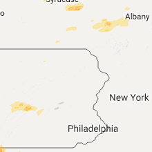
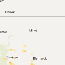
Hail Map for Saturday, August 12, 2017

Number of Impacted Households on 8/12/2017
0
Impacted by 1" or Larger Hail
0
Impacted by 1.75" or Larger Hail
0
Impacted by 2.5" or Larger Hail
Square Miles of Populated Area Impacted on 8/12/2017
0
Impacted by 1" or Larger Hail
0
Impacted by 1.75" or Larger Hail
0
Impacted by 2.5" or Larger Hail


Cities Most Affected by Hail Storms of 8/12/2017
| Hail Size | Demographics of Zip Codes Affected | ||||||
|---|---|---|---|---|---|---|---|
| City | Count | Average | Largest | Pop Density | House Value | Income | Age |
| Angora, NE | 2 | 1.75 | 1.75 | 1 | $48k | $28.9k | 49.8 |
| Winner, SD | 2 | 1.75 | 1.75 | 4 | $55k | $29.0k | 45.4 |
| South Heart, ND | 1 | 2.75 | 2.75 | 1 | $64k | $35.1k | 40.5 |
| Raleigh, ND | 1 | 2.75 | 2.75 | 1 | $26k | $31.3k | 51.5 |
| Stratton, NE | 1 | 2.00 | 2.00 | 1 | $38k | $26.1k | 50.9 |
| Otis, CO | 1 | 2.00 | 2.00 | 2 | $61k | $35.5k | 43.9 |
| Towanda, PA | 1 | 1.75 | 1.75 | 87 | $79k | $35.9k | 44.8 |
| Dunning, NE | 1 | 1.75 | 1.75 | 0 | $21k | $26.7k | 46.1 |
| Colome, SD | 1 | 1.75 | 1.75 | 2 | $25k | $27.6k | 44.0 |
| Hemingford, NE | 1 | 1.75 | 1.75 | 1 | $56k | $34.0k | 45.7 |
| Alliance, NE | 1 | 1.75 | 1.75 | 10 | $73k | $39.4k | 40.8 |
| Lemmon, SD | 1 | 1.75 | 1.75 | 2 | $85k | $28.6k | 50.7 |
Hail and Wind Damage Spotted on 8/12/2017
Filter by Report Type:Hail ReportsWind Reports
States Impacted
Texas, New York, Pennsylvania, Maryland, North Dakota, West Virginia, South Dakota, Montana, Nebraska, Vermont, Virginia, Colorado, District of Columbia, MassachusettsTexas
| Local Time | Report Details |
|---|---|
| 12:25 PM CDT | Sweetwater pd has relayed reports of winds taking down a few trees near the 1000 block of pines st in sweetwate in nolan county TX, 39.1 miles W of Abilene, TX |
| 3:45 PM CDT | 1-inch tree limbs broken. shingles blown of in grayson county TX, 58.1 miles SSW of Atoka, OK |
| 5:00 PM CDT | Delayed report. metal roof off a detached wood framed garage/workshop in collin county TX, 42.7 miles NNE of Dallas, TX |
| 6:48 PM CDT | Quarter sized hail reported near Colorado City, TX, 65.5 miles W of Abilene, TX |
| 7:40 PM CDT | A few large trees downed in the cr2319 are in van zandt county TX, 60.1 miles ESE of Dallas, TX |
| 9:06 PM CDT | 6 to 12 inch diameter trees downed in grayson county TX, 62.4 miles SW of Atoka, OK |
New York
| Local Time | Report Details |
|---|---|
| 2:00 PM EDT | Two reports of trees and wires down in oswego county NY, 28.7 miles NW of Syracuse, NY |
| 2:13 PM EDT | Trees and wires down in oswego county NY, 25.3 miles NW of Syracuse, NY |
| 2:13 PM EDT | Trees down in oswego county NY, 22.3 miles NW of Syracuse, NY |
| 2:36 PM EDT | Trees and wires down - time estimated by radar in oswego county NY, 22.1 miles N of Syracuse, NY |
| 2:56 PM EDT | Trees and wires down - time estimated by radar in oswego county NY, 20.3 miles NNE of Syracuse, NY |
| 3:05 PM EDT | Quarter sized hail reported near Williamstown, NY, 25.6 miles NNE of Syracuse, NY, nickel to quarter size hail 3 to 4 inches deep covering the ground |
| 3:10 PM EDT | Multiple trees uprooted. lines down. camps and boats damaged at sto-ne-nols campground. radar based time. media story onlin in oneida county NY, 26.4 miles NE of Syracuse, NY |
| 3:18 PM EDT | Trees and lines down. radar based tim in otsego county NY, 50.9 miles W of Schenectady, NY |
| 3:49 PM EDT | Quarter sized hail reported near Cincinnatus, NY, 38.4 miles SSE of Syracuse, NY, dime to quarter size hail |
| 4:00 PM EDT | Multiple trees down blocking road including at state park. via dispatch fee in chenango county NY, 42.5 miles SSE of Syracuse, NY |
| 4:15 PM EDT | Several trees down in area. photos sent by emergency mgmt. radar based tim in chenango county NY, 48 miles SE of Syracuse, NY |
| 4:20 PM EDT | Half Dollar sized hail reported near Morrisville, NY, 24.8 miles ESE of Syracuse, NY |
| 4:26 PM EDT | Ping Pong Ball sized hail reported near Munnsville, NY, 28.6 miles E of Syracuse, NY |
| 4:42 PM EDT | Trees and lines down in otsego county NY, 57.2 miles SE of Syracuse, NY |
| 4:43 PM EDT | Quarter sized hail reported near Ballston Spa, NY, 14.9 miles NNE of Schenectady, NY |
| 4:48 PM EDT | Tree dow in saratoga county NY, 15.2 miles NNE of Schenectady, NY |
| 4:49 PM EDT | Two trees down at the intersection of route 50 and hutchins roa in saratoga county NY, 16.2 miles NNE of Schenectady, NY |
| 5:06 PM EDT | Numerous trees and lines down. took brunt of storm. radar based tim in otsego county NY, 61.7 miles WSW of Schenectady, NY |
| 5:12 PM EDT | Trees and lines down. radar based tim in otsego county NY, 53.6 miles WSW of Schenectady, NY |
| 5:25 PM EDT | Trees and lines down. radar based tim in otsego county NY, 44.2 miles WSW of Schenectady, NY |
| 5:30 PM EDT | Numerous trees and lines down. took brunt of storm. radar based tim in otsego county NY, 39.4 miles WSW of Schenectady, NY |
| 5:30 PM EDT | Trees and lines down. radar based tim in otsego county NY, 44.2 miles WSW of Schenectady, NY |
| 5:40 PM EDT | Multiple trees and wires dow in schoharie county NY, 33.9 miles WSW of Schenectady, NY |
| 5:41 PM EDT | Quarter sized hail reported near Richmondville, NY, 35.3 miles WSW of Schenectady, NY |
| 5:42 PM EDT | House caught fire due to downed power line in schoharie county NY, 33.9 miles WSW of Schenectady, NY |
| 6:25 PM EDT | Tree downed in essex county NY, 38.5 miles SSW of Burlington, VT |
| 6:45 PM EDT | Trees down in albany county NY, 14.4 miles SSE of Schenectady, NY |
| 7:01 PM EDT | Quarter sized hail reported near East Greenbush, NY, 19.6 miles SE of Schenectady, NY |
| 7:05 PM EDT | 3 trees down and wires dow in rensselaer county NY, 23.6 miles ESE of Schenectady, NY |
Pennsylvania
| Local Time | Report Details |
|---|---|
| 2:17 PM EDT | Tree down across salem road between blue hollow road and jacks lane in armagh townshi in mifflin county PA, 16.1 miles ESE of State College, PA |
| 2:30 PM EDT | Wires down along north main street near thrid street in derry townshi in mifflin county PA, 18.2 miles SE of State College, PA |
| 2:56 PM EDT | Trees down near intersection of route 35 and jericho roa in juniata county PA, 29.4 miles ESE of State College, PA |
| 3:00 PM EDT | Trees down. numerous other trees down over the northern part of the county in juniata county PA, 32.5 miles ESE of State College, PA |
| 3:05 PM EDT | Reports of trees down and trees on wires in northern juniata count in juniata county PA, 32.5 miles ESE of State College, PA |
| 3:09 PM EDT | Reports of trees across roads in thompsontown in juniata county PA, 36.1 miles ESE of State College, PA |
| 3:30 PM EDT | Trees down in perry county PA, 48.3 miles ESE of State College, PA |
| 4:18 PM EDT | Golf Ball sized hail reported near Towanda, PA, 47.8 miles WNW of Scranton, PA |
| 5:05 PM EDT | Trees and wires down in lebanon county PA, 73.1 miles N of Baltimore, MD |
Maryland
| Local Time | Report Details |
|---|---|
| 3:27 PM EDT | Two trees down along turkey farm road northeas in allegany county MD, 81.4 miles SSW of State College, PA |
| 3:28 PM EDT | Tree down on oldtown orleans road southeast near apple roa in allegany county MD, 85 miles SSW of State College, PA |
| 5:20 PM EDT | Tree down blocking both directions of baltimore national pike at gambrill park roa in frederick county MD, 48.9 miles WNW of Baltimore, MD |
| 5:27 PM EDT | Poles and wires down on rosemont avenu in frederick county MD, 45 miles WNW of Baltimore, MD |
| 5:31 PM EDT | Quarter sized hail reported near Frederick, MD, 44.5 miles WNW of Baltimore, MD, quarter size hail |
| 5:32 PM EDT | Tree down blocking exit ramp at interstate 70 and highway 40 in frederick county MD, 44.1 miles W of Baltimore, MD |
| 6:08 PM EDT | Two trees down near the intersection of long corner road and new cut roa in howard county MD, 29.6 miles W of Baltimore, MD |
| 6:10 PM EDT | Quarter sized hail reported near Mount Airy, MD, 31.8 miles W of Baltimore, MD |
| 6:11 PM EDT | Tree down near the intersection of long corner road and gue roa in montgomery county MD, 30 miles W of Baltimore, MD |
| 6:26 PM EDT | Tree down in roadway near the intersection of southwestern boulevard and francis avenu in baltimore county MD, 5.5 miles SW of Baltimore, MD |
| 7:25 PM EDT | Tree down on clara barton parkway near the capital beltwa in montgomery county MD, 37.8 miles SW of Baltimore, MD |
| 7:26 PM EDT | Tree down in roadway near the intersection of southwestern boulevard and francis avenu in baltimore county MD, 5.5 miles SW of Baltimore, MD |
| 7:56 PM EDT | Wires down in the 4900 block of branchville roa in prince georges county MD, 26.4 miles SW of Baltimore, MD |
| 7:57 PM EDT | Wires down in the 500 block of crescent roa in prince georges county MD, 24.5 miles SW of Baltimore, MD |
| 8:05 PM EDT | Wires down in the 6700 block of parkwood stree in prince georges county MD, 29.4 miles SSW of Baltimore, MD |
| 8:15 PM EDT | Tree down blocking two right lanes of governor ritchie highway at cypress creek roa in anne arundel county MD, 15.7 miles SSE of Baltimore, MD |
| 8:24 PM EDT | Storm damage reported in anne arundel county MD, 16.3 miles SSE of Baltimore, MD |
| 8:49 PM EDT | Several large six inch in diameter tree limbs down along nottingham road and molly berry roa in prince georges county MD, 40.1 miles S of Baltimore, MD |
North Dakota
| Local Time | Report Details |
|---|---|
| 2:30 PM CDT | Quarter sized hail reported near Fredonia, ND, 58.7 miles NW of Aberdeen, SD, little damage to the soy beans. |
| 5:00 PM MDT | Baseball sized hail reported near South Heart, ND, 103.7 miles SSE of Williston, ND, est. 40 mph winds. |
| 5:08 PM MDT | Baseball sized hail reported near Raleigh, ND, 44.2 miles SW of Bismarck, ND, baseball sized hail bouncing 5 feet off the around. dents in his vehicle. |
| 6:00 PM MDT | Quarter sized hail reported near Hettinger, ND, 95.5 miles WSW of Bismarck, ND |
| 6:00 PM MDT | Quarter sized hail reported near Regent, ND, 92.2 miles WSW of Bismarck, ND |
West Virginia
| Local Time | Report Details |
|---|---|
| 3:40 PM EDT | Large tree down onto power lines along wild turkey lane in morgan county WV, 82.9 miles SSW of State College, PA |
| 3:40 PM EDT | Tree down on power lines on wild turkey roa in morgan county WV, 82.2 miles SSW of State College, PA |
| 3:43 PM EDT | Tree onto a car near panorama at the peak. no injurie in morgan county WV, 83.7 miles SSW of State College, PA |
| 3:43 PM EDT | Large tree down onto power lines along wild turkey lane in morgan county WV, 82.9 miles SSW of State College, PA |
| 3:44 PM EDT | Power lines down near the intersection of new hope road and guitar lan in morgan county WV, 83.7 miles SSW of State College, PA |
| 3:44 PM EDT | Multiple trees down across rt 9 near the intersection of quaint acres lane in morgan county WV, 83.6 miles SSW of State College, PA |
| 3:49 PM EDT | Several large trees... as many as 20 or more... down along spohrs rd between the intersections of new hope rd and eckerd ln in morgan county WV, 83.3 miles SSW of State College, PA |
| 3:56 PM EDT | Tree down on victory lan in morgan county WV, 81.2 miles S of State College, PA |
| 4:05 PM EDT | Quarter sized hail reported near Hedgesville, WV, 78.8 miles WNW of Baltimore, MD, dime to quarter size hail |
South Dakota
| Local Time | Report Details |
|---|---|
| 2:45 PM CDT | Quarter sized hail reported near Wood, SD, 50.3 miles S of Pierre, SD |
| 3:21 PM CDT | Half Dollar sized hail reported near Kennebec, SD, 42.8 miles SE of Pierre, SD, radar estimated time. |
| 3:28 PM CDT | Half Dollar sized hail reported near Kennebec, SD, 42.8 miles SE of Pierre, SD, radar estimated time. |
| 3:36 PM CDT | Golf Ball sized hail reported near Winner, SD, 46.5 miles NNE of Valentine, NE |
| 3:50 PM CDT | Golf Ball sized hail reported near Winner, SD, 47.4 miles NNE of Valentine, NE |
| 4:15 PM CDT | Quarter sized hail reported near Witten, SD, 49.2 miles NNE of Valentine, NE |
| 4:15 PM CDT | Storm damage reported in tripp county SD, 49.2 miles NNE of Valentine, NE |
| 4:20 PM CDT | Storm damage reported in tripp county SD, 43.1 miles NE of Valentine, NE |
| 4:30 PM CDT | Quarter sized hail reported near Winner, SD, 47.4 miles NE of Valentine, NE |
| 4:30 PM CDT | Storm damage reported in tripp county SD, 43.1 miles NE of Valentine, NE |
| 4:40 PM CDT | Storm damage reported in tripp county SD, 43.1 miles NE of Valentine, NE |
| 3:40 PM MDT | Quarter sized hail reported near Buffalo, SD, 99.5 miles N of Rapid City, SD |
| 4:50 PM CDT | Quarter sized hail reported near Winner, SD, 48.9 miles NE of Valentine, NE, window broken |
| 4:50 PM CDT | Window broken in tripp county SD, 48.9 miles NE of Valentine, NE |
| 4:15 PM MDT | Storm damage reported in harding county SD, 95.9 miles N of Rapid City, SD |
| 5:20 PM CDT | Quarter sized hail reported near Colome, SD, 47.7 miles NE of Valentine, NE |
| 4:26 PM MDT | Storm damage reported in perkins county SD, 87.9 miles N of Rapid City, SD |
| 4:30 PM MDT | Storm damage reported in perkins county SD, 93 miles N of Rapid City, SD |
| 5:45 PM CDT | Golf Ball sized hail reported near Colome, SD, 48.8 miles ENE of Valentine, NE |
| 6:35 PM MDT | Golf Ball sized hail reported near Lemmon, SD, 91.4 miles SW of Bismarck, ND |
| 6:56 PM MDT | Quarter sized hail reported near Mc Laughlin, SD, 64.6 miles S of Bismarck, ND, radar estimated time. |
| 7:00 PM MDT | Quarter sized hail reported near Lemmon, SD, 99 miles SW of Bismarck, ND |
| 7:33 PM MDT | Storm damage reported in dewey county SD, 54.3 miles NNW of Pierre, SD |
Montana
| Local Time | Report Details |
|---|---|
| 2:45 PM MDT | Quarter sized hail reported near Wibaux, MT, 84.7 miles SSW of Williston, ND, dime to quarter sized hail. |
Nebraska
| Local Time | Report Details |
|---|---|
| 3:56 PM CDT | Half Dollar sized hail reported near Halsey, NE, 60.4 miles NNE of North Platte, NE |
| 2:57 PM MDT | Golf Ball sized hail reported near Hemingford, NE, 34 miles NE of Scottsbluff, NE, brief hail with heavy rain. |
| 3:14 PM MDT | Golf Ball sized hail reported near Alliance, NE, 40.9 miles NE of Scottsbluff, NE |
| 3:30 PM MDT | Half Dollar sized hail reported near Alliance, NE, 42.5 miles ENE of Scottsbluff, NE, covers hwy 385 south of alliance. |
| 3:33 PM MDT | Golf Ball sized hail reported near Angora, NE, 35 miles ENE of Scottsbluff, NE, golf ball hail along highway 385. several cars on side of road with broken windows. |
| 3:34 PM MDT | Golf Ball sized hail reported near Angora, NE, 35 miles ENE of Scottsbluff, NE, several cars along the side of hwy 385 with broken windshields. |
| 3:49 PM MDT | Quarter sized hail reported near Bushnell, NE, 47.8 miles SSW of Scottsbluff, NE |
| 3:49 PM MDT | Quarter sized hail reported near Bushnell, NE, 45.2 miles SSW of Scottsbluff, NE |
| 4:07 PM MDT | Ping Pong Ball sized hail reported near Bridgeport, NE, 29.3 miles E of Scottsbluff, NE |
| 4:28 PM MDT | Quarter sized hail reported near Angora, NE, 38.2 miles E of Scottsbluff, NE |
| 5:35 PM CDT | Quarter sized hail reported near Dunning, NE, 51.2 miles NE of North Platte, NE |
| 6:00 PM CDT | Golf Ball sized hail reported near Dunning, NE, 58.1 miles NE of North Platte, NE |
| 6:40 PM CDT | Quarter sized hail reported near Thedford, NE, 38.9 miles S of Valentine, NE |
| 6:53 PM CDT | Quarter sized hail reported near Anselmo, NE, 57.7 miles NE of North Platte, NE |
| 7:18 PM CDT | Quarter sized hail reported near Ainsworth, NE, 53.2 miles SSE of Valentine, NE |
| 7:56 PM CDT | Quarter sized hail reported near Ainsworth, NE, 62.2 miles SSE of Valentine, NE |
| 8:21 PM CDT | Storm damage reported in custer county NE, 61.4 miles ENE of North Platte, NE |
| 8:21 PM CDT | Ping Pong Ball sized hail reported near Broken Bow, NE, 61.4 miles ENE of North Platte, NE |
| 8:40 PM CDT | Hen Egg sized hail reported near Stratton, NE, 60.8 miles NNW of Colby, KS |
| 9:05 PM CDT | Irrigation pivot systems flipped. systems belived to be full -- est. winds near 100 mph. time estimated from rada in custer county NE, 56.7 miles WNW of Grand Island, NE |
Vermont
| Local Time | Report Details |
|---|---|
| 6:00 PM EDT | Trees down on power line in addison county VT, 21.2 miles S of Burlington, VT |
| 6:12 PM EDT | Trees down on power line in addison county VT, 24.8 miles S of Burlington, VT |
| 6:18 PM EDT | Trees down on power line in addison county VT, 18.4 miles S of Burlington, VT |
| 6:20 PM EDT | Trees down on power lines on north williston road in chittenden county VT, 7.5 miles ESE of Burlington, VT |
| 6:30 PM EDT | Trees down on lee river rd in chittenden county VT, 11.6 miles E of Burlington, VT |
| 7:06 PM EDT | Trees down on powerlines in orleans county VT, 47.4 miles ENE of Burlington, VT |
| 7:36 PM EDT | Tree downed at lake parker in orleans county VT, 52 miles ENE of Burlington, VT |
| 7:42 PM EDT | Trees downed on powerlines in orleans county VT, 54.4 miles ENE of Burlington, VT |
| 7:42 PM EDT | Trees downed on powerlines in orleans county VT, 53 miles ENE of Burlington, VT |
| 7:42 PM EDT | Tree branches down in washington county VT, 41.6 miles ESE of Burlington, VT |
| 7:45 PM EDT | Trees downed on powerlines in brighton in essex county VT, 70.9 miles ENE of Burlington, VT |
Virginia
| Local Time | Report Details |
|---|---|
| 6:32 PM EDT | Quarter sized hail reported near Round Hill, VA, 63.3 miles W of Baltimore, MD, quarter size hail |
| 6:36 PM EDT | Tree down on telegraph springs road near fraklins ford plac in loudoun county VA, 60.2 miles W of Baltimore, MD |
| 7:45 PM EDT | Tree down near the intersection of columbia pike and south quincy stree in arlington county VA, 39.7 miles SW of Baltimore, MD |
| 8:34 PM EDT | Large tree limb down blocking sleepy hollow road near dearborn driv in fairfax county VA, 42.8 miles SW of Baltimore, MD |
Colorado
| Local Time | Report Details |
|---|---|
| 4:42 PM MDT | Hen Egg sized hail reported near Otis, CO, 18.6 miles W of Yuma, CO |
| 4:50 PM MDT | Quarter sized hail reported near Calhan, CO, 49.6 miles NNE of Pueblo, CO |
| 5:40 PM MDT | Quarter sized hail reported near Anton, CO, 31.4 miles SSW of Yuma, CO |
| 5:42 PM MDT | Ping Pong Ball sized hail reported near Anton, CO, 33.2 miles SSW of Yuma, CO |
District of Columbia
| Local Time | Report Details |
|---|---|
| 7:55 PM EDT | Tree down in the 1900 block of 4th street northwes in district of columb county DC, 33.8 miles SW of Baltimore, MD |
| 8:02 PM EDT | Tree down in the 1500 block of independence avenue southeas in district of columb county DC, 34.1 miles SW of Baltimore, MD |
Massachusetts
| Local Time | Report Details |
|---|---|
| 10:58 PM EDT | Large tree and wires down on residence in berkshire county MA, 42 miles SE of Schenectady, NY |
Connect with Interactive Hail Maps