

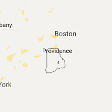
Hail Map for Wednesday, August 2, 2017

Number of Impacted Households on 8/2/2017
0
Impacted by 1" or Larger Hail
0
Impacted by 1.75" or Larger Hail
0
Impacted by 2.5" or Larger Hail
Square Miles of Populated Area Impacted on 8/2/2017
0
Impacted by 1" or Larger Hail
0
Impacted by 1.75" or Larger Hail
0
Impacted by 2.5" or Larger Hail


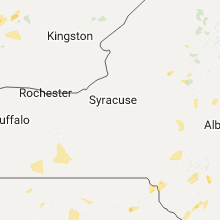


Cities Most Affected by Hail Storms of 8/2/2017
| Hail Size | Demographics of Zip Codes Affected | ||||||
|---|---|---|---|---|---|---|---|
| City | Count | Average | Largest | Pop Density | House Value | Income | Age |
| Wallace, NE | 4 | 2.06 | 2.75 | 1 | $55k | $36.5k | 42.3 |
| Paxton, NE | 4 | 2.00 | 2.50 | 2 | $55k | $30.8k | 43.4 |
| Cope, CO | 1 | 2.00 | 2.00 | 1 | $65k | $30.5k | 40.8 |
| Bondville, VT | 1 | 1.75 | 1.75 | 3 | $176k | $54.7k | 49.6 |
| Fleming, CO | 1 | 1.75 | 1.75 | 2 | $80k | $32.7k | 44.1 |
| Lexington, NE | 1 | 1.75 | 1.75 | 46 | $64k | $38.3k | 30.8 |
| Valhalla, NY | 1 | 1.75 | 1.75 | 992 | $329k | $70.5k | 38.2 |
| Quincy, CA | 1 | 1.75 | 1.75 | 35 | $135k | $36.9k | 45.5 |
| Arthur, NE | 1 | 1.75 | 1.75 | 0 | $48k | $30.5k | 43.8 |
Hail and Wind Damage Spotted on 8/2/2017
Filter by Report Type:Hail ReportsWind Reports
States Impacted
New Jersey, Maryland, New York, Connecticut, Pennsylvania, Rhode Island, Massachusetts, Ohio, Kentucky, Vermont, Colorado, Florida, New Hampshire, Alabama, Michigan, Maine, Nebraska, Arizona, West Virginia, Nevada, CaliforniaNew Jersey
| Local Time | Report Details |
|---|---|
| 12:42 PM EDT | Tree branches and power lines down in middlesex county NJ, 18.9 miles SW of Brooklyn, NY |
| 1:25 PM EDT | Trees down at martha road and parkwary street in bergen county NJ, 20.5 miles N of Brooklyn, NY |
| 3:14 PM EDT | Trees down near jackson. time estimated by rada in ocean county NJ, 43.8 miles SSW of Brooklyn, NY |
| 4:05 PM EDT | Large branches dow in middlesex county NJ, 25.1 miles WSW of Brooklyn, NY |
| 4:07 PM EDT | Large tree branches snapped in johnson park in middlesex county NJ, 27.3 miles WSW of Brooklyn, NY |
| 4:29 PM EDT | Several trees dow in gloucester county NJ, 82.9 miles ENE of Baltimore, MD |
| 5:19 PM EDT | Wires down near vineland. time estimated by rada in cumberland county NJ, 77.7 miles N of Ocean City, MD |
Maryland
| Local Time | Report Details |
|---|---|
| 12:48 PM EDT | Tree with 6 inch diameter trunk dow in harford county MD, 24.2 miles NE of Baltimore, MD |
| 1:04 PM EDT | Tree down in harford county MD, 18 miles NNE of Baltimore, MD |
| 1:38 PM EDT | Tree on wires in harford county MD, 24 miles NNE of Baltimore, MD |
| 2:40 PM EDT | Tree down near harkins rd and onion rd in harford county MD, 29.4 miles NNE of Baltimore, MD |
| 2:48 PM EDT | Tree down across 2100 block of mt horeb rd in harford county MD, 26.4 miles NNE of Baltimore, MD |
| 2:53 PM EDT | Wires down in harford county MD, 19.1 miles NNE of Baltimore, MD |
| 2:56 PM EDT | Tree down 2400 blk telegraph rd in harford county MD, 28.4 miles NNE of Baltimore, MD |
| 3:13 PM EDT | Downed tree in the 12200 block of stoney batter rd in baltimore county MD, 14.8 miles NE of Baltimore, MD |
| 3:21 PM EDT | Downed tree near joppa rd and philadelphia rd in baltimore county MD, 11.8 miles NE of Baltimore, MD |
| 9:25 PM EDT | Tree blown onto power line in queen annes county MD, 31.8 miles SE of Baltimore, MD |
New York
| Local Time | Report Details |
|---|---|
| 1:18 PM EDT | Tree limbs in ulster county NY, 63.8 miles SSW of Schenectady, NY |
| 1:25 PM EDT | Golf Ball sized hail reported near Valhalla, NY, 31.2 miles NNE of Brooklyn, NY, trained spotter measured 1.75 inch hail golf ball sized |
| 1:56 PM EDT | Trees and wires dow in ulster county NY, 65.8 miles S of Schenectady, NY |
| 2:02 PM EDT | Trees and wires dow in ulster county NY, 65.8 miles S of Schenectady, NY |
| 2:12 PM EDT | 20 inch decorative tree sheared off completel in ulster county NY, 66.3 miles ENE of Scranton, PA |
| 2:12 PM EDT | Large branch split off a 20 foot tall tree in ulster county NY, 65.8 miles S of Schenectady, NY |
| 2:45 PM EDT | Multiple trees down in orange county NY, 57.9 miles N of Brooklyn, NY |
| 2:50 PM EDT | Small trees down. numerous tree limb down in ulster county NY, 62.7 miles N of Brooklyn, NY |
| 3:41 PM EDT | Downed tree on ny17k westbound area of union street in orange county NY, 58.6 miles NNW of Brooklyn, NY |
| 7:13 PM EDT | Trees and lines down on patnode rd. at route 11 in clinton county NY, 48 miles NW of Burlington, VT |
| 7:54 PM EDT | Trees and lines down at intersection of hemmingford rd. and north star r in clinton county NY, 40.1 miles NNW of Burlington, VT |
Connecticut
| Local Time | Report Details |
|---|---|
| 1:20 PM EDT | Quarter sized hail reported near Coventry, CT, 46 miles W of Providence, RI, trained spotter |
| 2:12 PM EDT | Quarter sized hail reported near Coventry, CT, 46 miles W of Providence, RI, trained spotter |
| 3:12 PM EDT | Trees and wires dow in litchfield county CT, 66.2 miles NNE of Brooklyn, NY |
| 3:14 PM EDT | Tree down across roadwa in litchfield county CT, 75.2 miles SE of Schenectady, NY |
| 3:14 PM EDT | Tree down on power line in litchfield county CT, 76.3 miles SE of Schenectady, NY |
| 3:15 PM EDT | Tree down on power line in litchfield county CT, 76.3 miles SE of Schenectady, NY |
| 3:15 PM EDT | Wires down on holiday drive in hartford county CT, 60.6 miles W of Providence, RI |
| 3:45 PM EDT | Tree struck by lightning and caught fire. radar estimated tim in litchfield county CT, 77 miles SSE of Schenectady, NY |
| 3:52 PM EDT | Tree down on house on west middle road in hartford county CT, 57.3 miles W of Providence, RI |
| 3:57 PM EDT | Quarter sized hail reported near New Milford, CT, 72.3 miles NNE of Brooklyn, NY |
| 4:03 PM EDT | Route 341 and south kent road closed due to mutliple trees down and water across the road in litchfield county CT, 75.9 miles NNE of Brooklyn, NY |
| 4:03 PM EDT | Numerous trees and wires down along south kent road between spooner hill road and camps flat road in litchfield county CT, 73.8 miles NNE of Brooklyn, NY |
| 4:07 PM EDT | Tree down on riverside ave in litchfield county CT, 80.4 miles SSE of Schenectady, NY |
Pennsylvania
| Local Time | Report Details |
|---|---|
| 1:21 PM EDT | Trees/wires down in west perry twp in snyder county PA, 44.9 miles E of State College, PA |
| 1:21 PM EDT | Trees/wires down in west perry twp in snyder county PA, 40.8 miles E of State College, PA |
| 1:36 PM EDT | Trees down in perry twp in snyder county PA, 45.5 miles E of State College, PA |
| 2:05 PM EDT | Tree down in bedminster. time estimated by rada in bucks county PA, 65.2 miles WSW of Brooklyn, NY |
| 2:05 PM EDT | Tree down in haycock. time estimated by rada in bucks county PA, 67.5 miles SSE of Scranton, PA |
| 2:05 PM EDT | Tree down in springfield. time estimated by rada in bucks county PA, 64.8 miles SSE of Scranton, PA |
| 2:11 PM EDT | Quarter sized hail reported near Malvern, PA, 82 miles NE of Baltimore, MD, quarter-sized hail. |
| 2:18 PM EDT | Trees and large branches down in york county PA, 43.1 miles NNW of Baltimore, MD |
| 2:20 PM EDT | Tree down on roa in montgomery county PA, 83.3 miles WSW of Brooklyn, NY |
| 2:37 PM EDT | Large tree down across bald mountain rd in lackawanna county PA, 6.1 miles NNW of Scranton, PA |
| 2:43 PM EDT | Trees and powerlines down in dauphin county PA, 67.9 miles ESE of State College, PA |
| 9:32 PM EDT | Trees and wires down in lycoming county PA, 55.2 miles ENE of State College, PA |
Rhode Island
| Local Time | Report Details |
|---|---|
| 1:35 PM EDT | Tree down on providence pike at industrial drive in providence county RI, 11.2 miles NW of Providence, RI |
Massachusetts
| Local Time | Report Details |
|---|---|
| 2:10 PM EDT | Tree down on power lines at 711 pond street also tree down on annabel lane in norfolk county MA, 18.4 miles N of Providence, RI |
| 2:28 PM EDT | Quarter sized hail reported near Charlemont, MA, 56.6 miles ESE of Schenectady, NY, hail covering ground |
| 2:28 PM EDT | Quarter sized hail reported near Hadley, MA, 68.6 miles WNW of Providence, RI, hail covering ground |
| 2:40 PM EDT | Wires down on pearl street in suffolk county MA, 44.3 miles NNE of Providence, RI |
| 2:40 PM EDT | Tree down and uprooted on harborside drive in suffolk county MA, 42.5 miles NNE of Providence, RI |
| 2:54 PM EDT | Tree down on moving car on newtown road in middlesex county MA, 45.4 miles N of Providence, RI |
| 3:00 PM EDT | Tree and wires down on long hill road in worcester county MA, 42.9 miles NNW of Providence, RI |
| 3:05 PM EDT | Tree and wires down in worcester county MA, 42.9 miles NNW of Providence, RI |
| 3:15 PM EDT | Large tree on wires on stow road in middlesex county MA, 46.4 miles N of Providence, RI |
| 3:15 PM EDT | Tree down on car on great road with tree and wires down at a second location in middlesex county MA, 41.9 miles N of Providence, RI |
| 3:15 PM EDT | Tree down blocking taylor road in middlesex county MA, 42.1 miles N of Providence, RI |
| 3:24 PM EDT | Tree and wires down in middlesex county MA, 45.4 miles N of Providence, RI |
| 3:35 PM EDT | Tree down at 454 college highway in hampden county MA, 71.7 miles WNW of Providence, RI |
| 3:40 PM EDT | Tree down on sam west road into wires in hampden county MA, 71.7 miles WNW of Providence, RI |
| 3:40 PM EDT | Large limbs and wires down on pleasant and clinton streets in hampden county MA, 72.8 miles WNW of Providence, RI |
| 3:40 PM EDT | Large branch down on independence avenue in middlesex county MA, 44.2 miles NNE of Providence, RI |
| 3:40 PM EDT | Tree down on hanover street in hampden county MA, 67 miles WNW of Providence, RI |
| 3:45 PM EDT | Large limb on wires blocking arlington road with wires down on highland avenue in middlesex county MA, 45.3 miles NNE of Providence, RI |
| 3:52 PM EDT | Large tree limb down on old marlboro road at emerson road in middlesex county MA, 43.3 miles N of Providence, RI |
| 4:10 PM EDT | Wires down on high street at school street in worcester county MA, 46.2 miles NW of Providence, RI |
| 5:06 PM EDT | Quarter sized hail reported near Milford, MA, 23.2 miles NNW of Providence, RI |
| 5:11 PM EDT | Quarter sized hail reported near Milford, MA, 23.2 miles NNW of Providence, RI |
| 5:11 PM EDT | Tree down on south main street and tree down on route 140 in worcester county MA, 23.2 miles NNW of Providence, RI |
| 5:12 PM EDT | Two trees down on route 32a in worcester county MA, 60.1 miles NW of Providence, RI |
| 5:35 PM EDT | Trees down on neckhill road and gaskell street with the roads impassable in worcester county MA, 20.3 miles NNW of Providence, RI |
Ohio
| Local Time | Report Details |
|---|---|
| 2:43 PM EDT | Trees and utility lines downed route 86 and 53 in ashtabula county OH, 39.6 miles E of Cleveland, OH |
Kentucky
| Local Time | Report Details |
|---|---|
| 2:48 PM EDT | Dispatch reported trees down on stepstone road... ridge ave... slate ave... and kendall springs road. time estimated from rada in bath county KY, 32.5 miles NNE of Irvine, KY |
| 3:27 PM EDT | Tree down at parkers mill road and versailles roa in fayette county KY, 40.6 miles NW of Irvine, KY |
| 4:15 PM CDT | Trees fell on the roofs of two house in metcalfe county KY, 71.2 miles S of Louisville, KY |
Vermont
| Local Time | Report Details |
|---|---|
| 4:01 PM EDT | Golf Ball sized hail reported near Bondville, VT, 58.7 miles ENE of Schenectady, NY, golfball size hail. several trees down. |
Colorado
| Local Time | Report Details |
|---|---|
| 2:21 PM MDT | Asos station ril... rifle airpor in garfield county CO, 55.3 miles NE of Grand Junction, CO |
| 3:15 PM MDT | Quarter sized hail reported near Otis, CO, 7.3 miles W of Yuma, CO |
| 3:45 PM MDT | Quarter sized hail reported near Fleming, CO, 34.5 miles N of Yuma, CO |
| 4:00 PM MDT | Ping Pong Ball sized hail reported near Otis, CO, 12 miles W of Yuma, CO |
| 4:06 PM MDT | Golf Ball sized hail reported near Fleming, CO, 31.6 miles N of Yuma, CO |
| 4:14 PM MDT | Half Dollar sized hail reported near Fleming, CO, 29.7 miles NNW of Yuma, CO |
| 4:15 PM MDT | Half Dollar sized hail reported near Akron, CO, 19.7 miles SW of Yuma, CO |
| 4:15 PM MDT | Quarter sized hail reported near Otis, CO, 12.7 miles W of Yuma, CO |
| 4:45 PM MDT | Ping Pong Ball sized hail reported near Haxtun, CO, 36 miles N of Yuma, CO, extensive crop damage in vicinity of haxtun. hail measured 3-4 inches deep over a widespread area. |
| 4:55 PM MDT | Quarter sized hail reported near Anton, CO, 29.7 miles SSW of Yuma, CO |
| 5:05 PM MDT | Hen Egg sized hail reported near Cope, CO, 27.9 miles SSW of Yuma, CO |
| 6:29 PM MDT | Ping Pong Ball sized hail reported near Wild Horse, CO, 83.3 miles S of Yuma, CO, hail was mostly quarters and ping pong ball sized and covered the ground. wind measured at 54 mph before measuring device failed. windows broken and tree branches down. |
Florida
| Local Time | Report Details |
|---|---|
| 4:30 PM EDT | A tree was knocked down onto mcintosh road between proctor and ashton roads... blocking one lane of traffi in sarasota county FL, 16 miles SSE of Bradenton, FL |
New Hampshire
| Local Time | Report Details |
|---|---|
| 5:00 PM EDT | Trees down in merrimack county NH, 69.6 miles WSW of Portland, ME |
| 7:00 PM EDT | Trees and wires downed all over town in carroll county NH, 37.9 miles W of Portland, ME |
| 7:00 PM EDT | Large hail and strong winds. trees and wires downed from winds in carroll county NH, 40.6 miles WNW of Portland, ME |
Alabama
| Local Time | Report Details |
|---|---|
| 4:08 PM CDT | Tree split and came down on a house in florence... alabam in lauderdale county AL, 1.4 miles N of Florence, AL |
| 4:10 PM CDT | Large tree branch down on a ca in lauderdale county AL, 2.7 miles N of Florence, AL |
Michigan
| Local Time | Report Details |
|---|---|
| 5:22 PM EDT | Tree limbs down at belle isle state par in wayne county MI, 58.3 miles SE of Flint, MI |
| 6:05 PM EDT | Multiple downed trees along west rd. pictures shared on faceboo in wayne county MI, 65.2 miles SSE of Flint, MI |
Maine
| Local Time | Report Details |
|---|---|
| 5:40 PM EDT | Tree down and power out in oxford county ME, 45.4 miles NW of Portland, ME |
| 7:10 PM EDT | Large tree limbs down in oxford county ME, 35.1 miles WNW of Portland, ME |
Nebraska
| Local Time | Report Details |
|---|---|
| 4:00 PM MDT | Golf Ball sized hail reported near Arthur, NE, 46.2 miles NW of North Platte, NE, brief large hail up to golf ball size and heavy rain. |
| 5:19 PM CDT | Half Dollar sized hail reported near Sutherland, NE, 34.9 miles NW of North Platte, NE, 1.25 inch size hail and strong non-svr gusty winds |
| 4:49 PM MDT | Quarter sized hail reported near Hyannis, NE, 80.3 miles SW of Valentine, NE, heavy rain and quarter size hail |
| 4:56 PM MDT | Golf Ball sized hail reported near Paxton, NE, 32.1 miles W of North Platte, NE, pea to golf ball size hail |
| 5:05 PM MDT | Hen Egg sized hail reported near Paxton, NE, 28.1 miles W of North Platte, NE, via social media |
| 5:05 PM MDT | Corn crop stripped due to wind and hail in keith county NE, 28.1 miles W of North Platte, NE |
| 5:07 PM MDT | Golf Ball sized hail reported near Paxton, NE, 28.1 miles W of North Platte, NE, relayed by paxton fire department... golf ball size hail with 40 to 50 mph winds. |
| 5:09 PM MDT | Tennis Ball sized hail reported near Paxton, NE, 28.1 miles W of North Platte, NE, golf to tennis ball hail |
| 6:47 PM CDT | Baseball sized hail reported near Wallace, NE, 26 miles SW of North Platte, NE, storm chaser report baseball size hail |
| 6:48 PM CDT | Golf Ball sized hail reported near Wallace, NE, 25.6 miles SW of North Platte, NE |
| 7:01 PM CDT | Golf Ball sized hail reported near Wallace, NE, 29.1 miles SW of North Platte, NE, golf ball size hail exhibiting saucer shape |
| 7:20 PM CDT | Hen Egg sized hail reported near Wallace, NE, 33.3 miles SW of North Platte, NE |
| 7:31 PM CDT | Half Dollar sized hail reported near Trenton, NE, 53.4 miles N of Colby, KS |
| 7:36 PM CDT | Quarter sized hail reported near Trenton, NE, 53.5 miles N of Colby, KS |
| 7:36 PM CDT | Quarter sized hail reported near Trenton, NE, 53.4 miles N of Colby, KS |
| 6:37 PM MDT | Co-op estimated winds north of imperial in chase county NE, 61.2 miles SW of North Platte, NE |
| 6:40 PM MDT | Storm damage reported in chase county NE, 62.6 miles SW of North Platte, NE |
| 10:34 PM CDT | Golf Ball sized hail reported near Lexington, NE, 56.3 miles ESE of North Platte, NE, law enforcement reports golf ball size hail and estimated 60 mph winds at the intersection of road 761 and hiway 21. |
| 12:02 AM CDT | Quarter sized hail reported near Wood River, NE, 13.6 miles W of Grand Island, NE, trained spotter reports heavy rain... estimated wind gusts at 60 mph... and hail to the size of quarters. |
Arizona
| Local Time | Report Details |
|---|---|
| 4:32 PM MST | Spotter in valle vista area reported estimated wind gust of 60 mph and blowing dust with quarter mile visibilit in mohave county AZ, 68.5 miles NNE of Lake Havasu City, AZ |
| 4:50 PM MST | Trained spotter reported small limbs down and street signs down near valle vist in mohave county AZ, 70.2 miles NNE of Lake Havasu City, AZ |
| 5:31 PM MST | Storm damage reported in yuma county AZ, 0.5 miles NE of Yuma, AZ |
| 5:33 PM MST | Storm damage reported in yuma county AZ, 0.5 miles NW of Yuma, AZ |
| 6:41 PM MST | Trained spotter estimated 60 mph gust and visibility estimated less than quarter mile near mohave valle in mohave county AZ, 34.8 miles NNW of Lake Havasu City, AZ |
West Virginia
| Local Time | Report Details |
|---|---|
| 7:45 PM EDT | Mping report of 1 inch branches broken and some shingles blown off roo in jackson county WV, 41.2 miles N of Charleston, WV |
Nevada
| Local Time | Report Details |
|---|---|
| 6:44 PM PDT | Site lxvg in clark county NV, 7.9 miles SE of Las Vegas, NV |
California
| Local Time | Report Details |
|---|---|
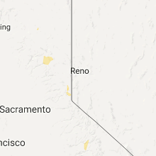
| 7:50 PM PDT | Golf Ball sized hail reported near Quincy, CA, 60.6 miles WNW of Reno, NV, reports of golf ball size hail southeast of quincy in the vicinity of the minerva fire. |
Connect with Interactive Hail Maps