

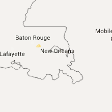
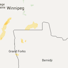
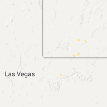
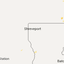
Hail Map for Saturday, August 22, 2015

Number of Impacted Households on 8/22/2015
0
Impacted by 1" or Larger Hail
0
Impacted by 1.75" or Larger Hail
0
Impacted by 2.5" or Larger Hail
Square Miles of Populated Area Impacted on 8/22/2015
0
Impacted by 1" or Larger Hail
0
Impacted by 1.75" or Larger Hail
0
Impacted by 2.5" or Larger Hail


Cities Most Affected by Hail Storms of 8/22/2015
| Hail Size | Demographics of Zip Codes Affected | ||||||
|---|---|---|---|---|---|---|---|
| City | Count | Average | Largest | Pop Density | House Value | Income | Age |
| Courtland, MS | 2 | 1.75 | 1.75 | 61 | $55k | $29.7k | 35.2 |
| De Witt, NE | 1 | 1.75 | 1.75 | 8 | $64k | $40.7k | 45.1 |
| Assaria, KS | 1 | 1.75 | 1.75 | 14 | $95k | $42.8k | 42.9 |
| Beatrice, NE | 1 | 1.75 | 1.75 | 70 | $73k | $35.2k | 43.5 |
| Clearwater, KS | 1 | 1.75 | 1.75 | 46 | $99k | $52.0k | 39.0 |
Hail and Wind Damage Spotted on 8/22/2015
Filter by Report Type:Hail ReportsWind Reports
States Impacted
Oklahoma, Kansas, North Dakota, Alabama, South Carolina, Tennessee, Texas, Minnesota, Nebraska, Georgia, Arizona, Mississippi, Iowa, North Carolina, New Mexico, Florida, MissouriOklahoma
| Local Time | Report Details |
|---|---|
| 7:43 AM CDT | Storm damage reported in payne county OK, 52.4 miles NNE of Oklahoma City, OK |
| 7:50 AM CDT | Storm damage reported in payne county OK, 50.5 miles NNE of Oklahoma City, OK |
| 7:50 AM CDT | Large trees snapped. relayed by kotv via twitte in payne county OK, 50.8 miles NNE of Oklahoma City, OK |
| 8:15 AM CDT | Quarter sized hail reported near Stillwater, OK, 51.6 miles NNE of Oklahoma City, OK, north side of stillwater |
| 8:20 AM CDT | Storm damage reported in lincoln county OK, 41.4 miles NE of Oklahoma City, OK |
| 10:10 AM CDT | Storm damage reported in hughes county OK, 60.1 miles S of Tulsa, OK |
| 10:10 AM CDT | Tree blown on to roof of house in hughes county OK, 60.7 miles S of Tulsa, OK |
| 10:12 AM CDT | Power poles down in hughes county OK, 60.7 miles S of Tulsa, OK |
Kansas
| Local Time | Report Details |
|---|---|
| 7:50 AM CDT | Golf Ball sized hail reported near Clearwater, KS, 15.2 miles SW of Wichita, KS, trained spotter reporting golf ball sized hail with varying sizes covering the ground. |
| 8:25 AM CDT | Quarter sized hail reported near Valley Center, KS, 10.7 miles N of Wichita, KS, public report via facebook of quarter sized hail on the west side of valley center. time is estimated from radar. |
| 7:34 PM CDT | Quarter sized hail reported near Hanover, KS, 51.9 miles NNW of Manhattan, KS |
| 8:04 PM CDT | Quarter sized hail reported near Marysville, KS, 45.9 miles N of Manhattan, KS |
| 8:38 PM CDT | Quarter sized hail reported near Barnes, KS, 33.7 miles NNW of Manhattan, KS |
| 10:01 PM CDT | Pea sized hail was also reporte in saline county KS, 67.8 miles WSW of Manhattan, KS |
| 10:36 PM CDT | Golf Ball sized hail reported near Assaria, KS, 65.7 miles WSW of Manhattan, KS, 65 mph winds also reported.the ground is covered with hail relayed via saline co. emergency management. |
| 11:24 PM CDT | Quarter sized hail reported near Canton, KS, 48.8 miles N of Wichita, KS |
| 11:28 PM CDT | Storm damage reported in mcpherson county KS, 48.8 miles N of Wichita, KS |
| 11:41 PM CDT | Quarter sized hail reported near Galva, KS, 43.5 miles NNW of Wichita, KS |
| 12:21 AM CDT | Storm damage reported in saline county KS, 64.1 miles WSW of Manhattan, KS |
| 3:25 AM CDT | Large trees downed in girard ks. large trees were also reported down across mutiple locations across crawford county when the line of storms passed throug in crawford county KS, 35.6 miles ESE of Chanute, KS |
| 3:40 AM CDT | Large trees reported down in pittsburg. winds were estimated at 60 mp in crawford county KS, 45.3 miles ESE of Chanute, KS |
North Dakota
| Local Time | Report Details |
|---|---|
| 10:22 AM CDT | Quarter sized hail reported near Milton, ND, 49.3 miles NE of Devils Lake, ND |
Alabama
| Local Time | Report Details |
|---|---|
| 1:10 PM CDT | Few small trees down off cr 41 about a mile from hwy 25. winds estimated around 40 mph based on radar. time estimated from rada in shelby county AL, 14.7 miles E of Birmingham, AL |
| 3:25 PM CDT | Shed blown over and multiple trees down in lauderdale county AL, 17.1 miles ENE of Florence, AL |
| 3:48 PM CDT | Power line down on rose street in lauderdale county AL, 22 miles E of Florence, AL |
| 3:48 PM CDT | Sheriff reported trees and power lines down as well as a tree on a car north of highway 7 in lauderdale county AL, 20.9 miles E of Florence, AL |
| 5:14 PM CDT | Power line and trees down across lee stree in lauderdale county AL, 22 miles E of Florence, AL |
| 5:40 PM CDT | Tree limbs and power lines down at the intersection of corner road and mayfield circle near the corner community blocking the roadway. winds estimated 40mph from rada in jefferson county AL, 21.3 miles NNW of Birmingham, AL |
South Carolina
| Local Time | Report Details |
|---|---|
| 4:00 PM EDT | Tree down on ulmer rd near the intersection of long pond rd. time estimated from radar in allendale county SC, 54.5 miles ESE of Augusta, GA |
| 4:36 PM EDT | Tree down on hwy 63 at tobys bluff ln. time estimated by rada in colleton county SC, 57.4 miles N of Savannah, GA |
| 4:45 PM EDT | Tree down at hwy 68 and bob gifford blvd. time estimated by rada in hampton county SC, 46.9 miles N of Savannah, GA |
| 5:28 PM EDT | Tree down at highway 17 and old sheldon church rd. time estimated by rada in beaufort county SC, 40.4 miles NNE of Savannah, GA |
| 5:52 PM EDT | Trees and power lines down on palmetto bluff rd in beaufort county SC, 13.6 miles NE of Savannah, GA |
| 6:05 PM EDT | Tree down at the intersection of seaside rd and cuffy rd on st helena island in beaufort county SC, 33.5 miles ENE of Savannah, GA |
Tennessee
| Local Time | Report Details |
|---|---|
| 3:02 PM CDT | A roof was blown off a building and numerous tree limbs down. time is radar estimate in mcnairy county TN, 46.4 miles WNW of Florence, AL |
| 3:40 PM CDT | Trees down on yokely rd. event time radar estimate in giles county TN, 53.7 miles NE of Florence, AL |
| 3:45 PM CDT | Trees down on happy hill rd in lynnville. event time radar estimate in giles county TN, 54.9 miles NE of Florence, AL |
| 4:40 PM CDT | Trees down on yokely rd. event time radar estimate in giles county TN, 53.7 miles NE of Florence, AL |
| 4:45 PM CDT | Trees down on happy hill rd in lynnville. event time radar estimate in giles county TN, 54.9 miles NE of Florence, AL |
Texas
| Local Time | Report Details |
|---|---|
| 4:31 PM CDT | Power line down at the intersection of kurth drive and lakeview street in lufki in angelina county TX, 1.4 miles NNW of Lufkin, TX |
Minnesota
| Local Time | Report Details |
|---|---|
| 4:40 PM CDT | Trees down. report relayed through law enforcemen in douglas county MN, 73.1 miles N of Montevideo, MN |
Nebraska
| Local Time | Report Details |
|---|---|
| 5:20 PM CDT | Golf Ball sized hail reported near De Witt, NE, 78.5 miles SW of Omaha, NE |
| 5:22 PM CDT | Quarter sized hail reported near De Witt, NE, 78.5 miles SW of Omaha, NE |
| 5:59 PM CDT | Quarter sized hail reported near Beatrice, NE, 79.3 miles SW of Omaha, NE |
| 5:59 PM CDT | Golf Ball sized hail reported near Beatrice, NE, 78.9 miles N of Manhattan, KS |
| 6:32 PM CDT | Quarter sized hail reported near Bellevue, NE, 7 miles S of Omaha, NE |
Georgia
| Local Time | Report Details |
|---|---|
| 6:46 PM EDT | Tree down on belfast keller road. time estimated based on rada in bryan county GA, 21.2 miles SW of Savannah, GA |
| 8:00 PM EDT | Dispatch reported a tree downed in southern wayne count in wayne county GA, 56.8 miles E of Douglas, GA |
| 8:15 PM EDT | Em reported multiple trees downed on hwy 3 in glynn county GA, 64 miles N of Jacksonville, FL |
| 8:25 PM EDT | Em reported a tree downed on a residence. no injurie in glynn county GA, 64 miles N of Jacksonville, FL |
| 9:00 PM EDT | Camden county 911/dispatch reports numerous trees and powerlines downed by strong wind gusts throughout the count in camden county GA, 43.5 miles N of Jacksonville, FL |
| 9:40 PM EDT | Numerous trees down. backyard fence downe in camden county GA, 28.9 miles N of Jacksonville, FL |
| 9:40 PM EDT | Trained spotter reports large tree downed and blocking mariners drive. utility wires were downed near the intersection of highway 40 and kings bay road. multiple trees in camden county GA, 30.3 miles N of Jacksonville, FL |
Arizona
| Local Time | Report Details |
|---|---|
| 4:06 PM MST | Web report of tree limbs down near the golf links and swan are in pima county AZ, 4.5 miles SE of Tucson, AZ |
| 4:12 PM MST | Quarter sized hail reported near Tucson, AZ, 4.3 miles S of Tucson, AZ, twitter report of quarter sized hail at the park/irvington road area. |
| 4:40 PM MST | Picture via twitter shows tree down at the corner of 6th avenue and 26th stree in pima county AZ, 1.5 miles S of Tucson, AZ |
| 4:45 PM MST | Twitter video shows a roughly 1-1.5 foot diameter tree limb on a car near 4th avenue and e 7th stree in pima county AZ, 0.6 miles N of Tucson, AZ |
Mississippi
| Local Time | Report Details |
|---|---|
| 6:14 PM CDT | Golf Ball sized hail reported near Courtland, MS, 63 miles S of Memphis, TN, golfball sized hail at whitten and hughes just south of highway 6 on highway 35 west of the town of cortland. |
| 6:35 PM CDT | Golf Ball sized hail reported near Courtland, MS, 63 miles S of Memphis, TN, golfball sized hail at whitten and hughes just south of highway 6 on highway 35 west of the town of cortland. |
Iowa
| Local Time | Report Details |
|---|---|
| 6:48 PM CDT | Large street signs and trees reported down along highway 34 to the east of i2 in mills county IA, 16.8 miles SSE of Omaha, NE |
North Carolina
| Local Time | Report Details |
|---|---|
| 8:20 PM EDT | Trees and power lines down along chunns cove road near tunnel road likely due to a combination of extremely heavy rain and gusty win in buncombe county NC, 53.2 miles N of Greenville, SC |
New Mexico
| Local Time | Report Details |
|---|---|
| 7:35 PM MDT | Storm damage reported in grant county NM, 12.1 miles SE of Silver City, NM |
Florida
| Local Time | Report Details |
|---|---|
| 10:30 PM EDT | Hamilton county 911/dispatch reports trees downed by strong wind gusts along 2nd avenue northwest in jasper and county road 6 east and 120th avenu in hamilton county FL, 68.2 miles S of Douglas, GA |
Missouri
| Local Time | Report Details |
|---|---|
| 3:25 AM CDT | Several large limbs and power lines were reported downed primarily across the northwestern portions of nevad in vernon county MO, 61.3 miles E of Chanute, KS |
| 4:06 AM CDT | Storm damage reported in jasper county MO, 64.4 miles SE of Chanute, KS |
| 4:10 AM CDT | Mutiple trees downed on peace church ave between carl junction and joplin. a large limb was also reported downed on 18th and empire in jopli in jasper county MO, 59.6 miles SE of Chanute, KS |
| 4:45 AM CDT | There are reports of power lines down in neosh in newton county MO, 64 miles WSW of Springfield, MO |
| 4:55 AM CDT | Trees and power lines reported down on agnes st in crane by amateur radio and emergency manage in stone county MO, 25.7 miles SW of Springfield, MO |
Connect with Interactive Hail Maps