

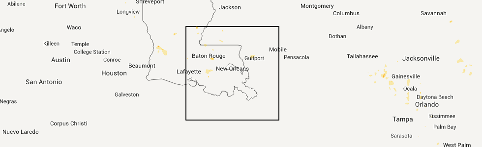
Hail Map for Tuesday, August 23, 2011
Number of Impacted Households on 8/23/2011
0
Impacted by 1" or Larger Hail
0
Impacted by 1.75" or Larger Hail
0
Impacted by 2.5" or Larger Hail
Square Miles of Populated Area Impacted on 8/23/2011
0
Impacted by 1" or Larger Hail
0
Impacted by 1.75" or Larger Hail
0
Impacted by 2.5" or Larger Hail


Cities Most Affected by Hail Storms of 8/23/2011
| Hail Size | Demographics of Zip Codes Affected | ||||||
|---|---|---|---|---|---|---|---|
| City | Count | Average | Largest | Pop Density | House Value | Income | Age |
| Thorp, WI | 1 | 1.75 | 1.75 | 23 | $66k | $31.9k | 35.6 |
| Imboden, AR | 1 | 1.75 | 1.75 | 20 | $49k | $24.7k | 41.6 |
Hail and Wind Damage Spotted on 8/23/2011
Filter by Report Type:Hail ReportsWind Reports
States Impacted
Iowa, Florida, Mississippi, Arkansas, Wisconsin, Indiana, Texas, Georgia, Arizona, Louisiana, OhioIowa
| Local Time | Report Details |
|---|---|
| 1:30 PM UTC | A number of 3 to 4 inch diameter tree branches down across their yar in fayette county IA, 59.6 miles N of Cedar Rapids, IA |
| 1:30 PM UTC | Fayette county sheriff reports that the main wind damage is in wadena with a number of trees blown down ther in fayette county IA, 59.6 miles N of Cedar Rapids, IA |
| 1:30 PM UTC | Trees down across wadena with a few of them uprooted and on power lines. 2 inch diameter flagpole bent over as well. everything looks like straightline wind damag in fayette county IA, 59.6 miles N of Cedar Rapids, IA |
| 1:30 PM UTC | Two trees knocked down with one split down the middle and on power lines with another that fell between a house and garage. tree trunk size estimated at a foot and a ha in fayette county IA, 59.6 miles N of Cedar Rapids, IA |
Florida
| Local Time | Report Details |
|---|---|
| 7:35 PM UTC | A radio station in ocala received a report of a tree blocking 2 lanes of i-75 north near mile marker 374. the time given was based on rada in alachua county FL, 69.1 miles SW of Jacksonville, FL |
| 9:30 PM UTC | Roof damage to a mobile home along with some trees knocked down/damaged in the vicinity. time estimated by rada in levy county FL, 90.9 miles SW of Jacksonville, FL |
Mississippi
| Local Time | Report Details |
|---|---|
| 8:15 PM UTC | Trees reported down on short road and ratliff road in hinds county MS, 16.1 miles WSW of Jackson, MS |
| 11:09 PM UTC | Measured at hbg in forrest county MS, 85.2 miles SE of Jackson, MS |
Arkansas
| Local Time | Report Details |
|---|---|
| 8:51 PM UTC | Gas station reported that trees are down across ash flat. several trees fell on power lines and downed them. some residents are without power at this tim in sharp county AR, 97.1 miles S of Salem, MO |
| 9:30 PM UTC | Trees down on hwy 82 in geno in miller county AR, 43.2 miles S of Nashville, AR |
| 4:46 PM CDT | Golf Ball sized hail reported near Imboden, AR, 96.4 miles NW of Memphis, TN |
Wisconsin
| Local Time | Report Details |
|---|---|
| 3:59 PM CDT | Quarter sized hail reported near Stanley, WI, 87.2 miles WSW of Rhinelander, WI |
| 4:00 PM CDT | Quarter sized hail reported near Stanley, WI, 83 miles WSW of Rhinelander, WI |
| 4:24 PM CDT | Golf Ball sized hail reported near Thorp, WI, 82.3 miles SW of Rhinelander, WI |
| 9:38 PM UTC | Power out in corning township in lincoln county WI, 37.9 miles SSW of Rhinelander, WI |
| 4:44 PM CDT | Quarter sized hail reported near Thorp, WI, 79.7 miles NNE of La Crosse, WI |
| 5:01 PM CDT | Quarter sized hail reported near Loyal, WI, 74.1 miles NNE of La Crosse, WI |
| 10:05 PM UTC | Sporadic power outages and house fire reported in tomahaw in lincoln county WI, 19.8 miles SW of Rhinelander, WI |
| 10:20 PM UTC | Power lines down on pine creek road and county y in clark county WI, 71.5 miles NE of La Crosse, WI |
| 5:44 PM CDT | Half Dollar sized hail reported near Neillsville, WI, 61.2 miles NNE of La Crosse, WI |
| 10:58 PM UTC | Power lines down. possible tornado damag in clark county WI, 74 miles NE of La Crosse, WI |
| 11:00 PM UTC | Trees down in the red springs township in shawano county WI, 44.1 miles WNW of Green Bay, WI |
| 11:12 PM UTC | Trees down along highway h in wood county WI, 71.7 miles SSW of Rhinelander, WI |
| 2:05 AM UTC | Trees down in calumet county WI, 26.9 miles SSW of Green Bay, WI |
| 9:10 PM CDT | Quarter sized hail reported near Brillion, WI, 22 miles SSW of Green Bay, WI |
Indiana
| Local Time | Report Details |
|---|---|
| 9:38 PM UTC | One tree down along sr 5 in greene county IN, 64.8 miles SW of Indianapolis, IN |
| 9:49 PM UTC | A few three and a quarter inch diameter trees dow in greene county IN, 59.3 miles SSW of Indianapolis, IN |
Texas
| Local Time | Report Details |
|---|---|
| 9:55 PM UTC | Trees and powerlines down on county road 3103 in malt in bowie county TX, 49.5 miles SW of Nashville, AR |
| 10:00 PM UTC | Roof partially removed from a home and a barn was destroyed. numerous powerlines down als in bowie county TX, 47.1 miles SW of Nashville, AR |
| 11:10 PM UTC | Trees dowm and wind damage to residence near leigh in harrison county TX, 24.8 miles WNW of Shreveport, LA |
| 11:35 PM UTC | Trees and powerlines down in upshur county TX, 64.3 miles W of Shreveport, LA |
| 12:25 AM UTC | Trees down also several grass fires from lightning strikes across county in smith county TX, 78.2 miles NNW of Lufkin, TX |
| 12:30 AM UTC | Trees down in smith county TX, 64.4 miles NNW of Lufkin, TX |
| 12:35 AM UTC | Trees and powerlines down and roof blown off a building in rusk county TX, 56.5 miles N of Lufkin, TX |
| 12:45 AM UTC | Trees down in smith county TX, 74.5 miles NNW of Lufkin, TX |
| 12:45 AM UTC | Trees down in panola county TX, 48.7 miles WSW of Shreveport, LA |
| 1:25 AM UTC | Two large trees down on fm 1970 in clayton and several grassfires started by lightning across the count in panola county TX, 48.6 miles SW of Shreveport, LA |
Georgia
| Local Time | Report Details |
|---|---|
| 9:57 PM UTC | Two trees reported down along main street and smith av in chatham county GA, 4.4 miles NW of Savannah, GA |
Arizona
| Local Time | Report Details |
|---|---|
| 10:58 PM UTC | Storm damage reported in santa cruz county AZ, 54.2 miles SSE of Tucson, AZ |
| 11:08 PM UTC | Storm damage reported in santa cruz county AZ, 54.2 miles SSE of Tucson, AZ |
| 11:25 PM UTC | Roof ripped off barn in canel in santa cruz county AZ, 54.2 miles SSE of Tucson, AZ |
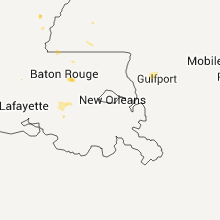
Louisiana
| Local Time | Report Details |
|---|---|
| 11:25 PM UTC | Trees and powerlines down near the community of whitehall in la salle county LA, 80.1 miles S of Bastrop, LA |
| 11:55 PM UTC | Tree down in de soto county LA, 43.1 miles SSE of Shreveport, LA |
| 12:10 AM UTC | A microburst snapped and uprooted a number of trees near the intersection of buncomb and woolworth road in far southwest shreveport. other trees were snapped and blown in caddo county LA, 4.3 miles SW of Shreveport, LA |
| 12:10 AM UTC | Trees and powerlines down on reddix road in pelica in de soto county LA, 43.1 miles SSE of Shreveport, LA |
| 12:10 AM UTC | Trees down on greenwood-springridge roa in caddo county LA, 16.4 miles SW of Shreveport, LA |
| 12:10 AM UTC | Powerlines down on woolworth roa in caddo county LA, 9.3 miles SW of Shreveport, LA |
| 12:25 AM UTC | Trees blown over on fence in wallace lake estate in caddo county LA, 12.1 miles S of Shreveport, LA |
Ohio
| Local Time | Report Details |
|---|---|
| 11:20 AM UTC | A few trees down across central portions of fairfield count in fairfield county OH, 27.2 miles SE of Columbus, OH |
Connect with Interactive Hail Maps