

Hail Map for Sunday, August 24, 2014

Number of Impacted Households on 8/24/2014
0
Impacted by 1" or Larger Hail
0
Impacted by 1.75" or Larger Hail
0
Impacted by 2.5" or Larger Hail
Square Miles of Populated Area Impacted on 8/24/2014
0
Impacted by 1" or Larger Hail
0
Impacted by 1.75" or Larger Hail
0
Impacted by 2.5" or Larger Hail


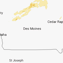


Cities Most Affected by Hail Storms of 8/24/2014
| Hail Size | Demographics of Zip Codes Affected | ||||||
|---|---|---|---|---|---|---|---|
| City | Count | Average | Largest | Pop Density | House Value | Income | Age |
| Hillman, MN | 1 | 2.00 | 2.00 | 12 | $98k | $33.8k | 44.0 |
| Brainerd, MN | 1 | 1.75 | 1.75 | 95 | $91k | $35.5k | 38.0 |
Hail and Wind Damage Spotted on 8/24/2014
Filter by Report Type:Hail ReportsWind Reports
Iowa
| Local Time | Report Details |
|---|---|
| 11:55 AM CDT | Quarter sized hail reported near Fort Dodge, IA, 52.6 miles E of Storm Lake, IA, pea to quarter sized hail at residence |
| 2:05 AM CDT | Small tree branches down and power knocked out in town possible transformer struck by lightning in floyd county IA, 30.9 miles E of Mason City, IA |
| 2:16 AM CDT | Several trees blown down in howard county IA, 50.9 miles ENE of Mason City, IA |
Alabama
| Local Time | Report Details |
|---|---|
| 4:00 PM CDT | Tree down at the 7000 block of highway 52 east in houston county AL, 80.6 miles NW of Tallahassee, FL |
| 4:14 PM CDT | Tree down at 1900 jimbo road in houston county AL, 82.4 miles NW of Tallahassee, FL |
| 4:18 PM CDT | Trees and power lines down around ozark in dale county AL, 80.4 miles S of Auburn, AL |
| 4:31 PM CDT | Tree down near the intersection of highway 167 and highway 125 in coffee county AL, 77.9 miles SSW of Auburn, AL |
Florida
| Local Time | Report Details |
|---|---|
| 5:08 PM EDT | Trees and several large branches down along williams road off of apalachee pkwy in leon county FL, 8 miles ESE of Tallahassee, FL |
| 5:14 PM EDT | Awos station 1 w macdill air force /mcf/ in hillsborough county FL, 24.7 miles N of Bradenton, FL |
| 5:16 PM EDT | Several large tree limbs snapped near the intersection of south himes avenue and west morrison avenu in hillsborough county FL, 30.3 miles N of Bradenton, FL |
Texas
| Local Time | Report Details |
|---|---|
| 4:10 PM CDT | Two overturned semis in goodnight due to strong winds in armstrong county TX, 38.5 miles ESE of Amarillo, TX |
| 7:15 PM CDT | Storm damage reported in andrews county TX, 33.4 miles NNW of Odessa, TX |
Mississippi
| Local Time | Report Details |
|---|---|
| 5:10 PM CDT | Trees and fences blown down throughout neighborhood...blew chimney off of roof in desoto county MS, 13.1 miles S of Memphis, TN |
Minnesota
| Local Time | Report Details |
|---|---|
| 5:48 PM CDT | Golf Ball sized hail reported near Brainerd, MN, 86.1 miles SSE of Bemidji, MN |
| 6:06 PM CDT | Hen Egg sized hail reported near Hillman, MN, 71.1 miles NNW of Minneapolis, MN, a trained spotter reported 2.2 inch diameter hail 7.5 miles south of hillman. |
| 1:30 AM CDT | Quarter sized hail reported near Le Roy, MN, 42.9 miles NE of Mason City, IA, kaal-tv viewer |
| 2:09 AM CDT | Tree down. power outages. nickel size hai in fillmore county MN, 42.6 miles WSW of La Crosse, WI |
Kansas
| Local Time | Report Details |
|---|---|
| 5:55 PM CDT | Damage to outbuildings reporte in marshall county KS, 40.5 miles NNE of Manhattan, KS |
| 5:55 PM CDT | Reported windgust of 75 mph. almost blew 18 wheeler over on us-8 in ottawa county KS, 60 miles W of Manhattan, KS |
| 6:04 PM CDT | Winds damaged a shed and grain bi in nemaha county KS, 46.8 miles NNE of Manhattan, KS |
| 6:13 PM CDT | Tree limbs blown down causing power outages in tow in nemaha county KS, 52.3 miles NNE of Manhattan, KS |
| 6:34 PM CDT | Quarter sized hail reported near Miltonvale, KS, 47.2 miles WNW of Manhattan, KS |
| 7:45 PM CDT | Quarter sized hail reported near Minneapolis, KS, 60 miles W of Manhattan, KS, 1 inch hail reported. |
| 7:45 PM CDT | Reported windgust of 75 mph. almost blew 18 wheeler over on us-8 in ottawa county KS, 60 miles W of Manhattan, KS |
Wisconsin
| Local Time | Report Details |
|---|---|
| 1:47 AM CDT | Excel energy reports 69 customers without power in clark county WI, 82.3 miles SW of Rhinelander, WI |
| 2:45 AM CDT | Trees are uprooted onto houses and across roads... and power lines are dow in clark county WI, 66.5 miles NE of La Crosse, WI |
| 2:48 AM CDT | Excel energy reported 37 customers without power in clark county WI, 67 miles SW of Rhinelander, WI |
| 3:00 AM CDT | Trees and powerlines dow in la crosse county WI, 9.1 miles NNW of La Crosse, WI |
| 3:00 AM CDT | Trees down on county rd s in la crosse county WI, 5.6 miles NNE of La Crosse, WI |
| 3:07 AM CDT | Trees and power lines blown down in jackson county WI, 25.3 miles NNE of La Crosse, WI |
| 3:20 AM CDT | Trees and power lines blown down between melrose and black river falls in jackson county WI, 39.2 miles NNE of La Crosse, WI |
| 3:36 AM CDT | Trees down and power outage in monroe county WI, 23.8 miles ENE of La Crosse, WI |
| 4:36 AM CDT | Power lines down in cit in portage county WI, 71.6 miles W of Green Bay, WI |
| 4:53 AM CDT | Trees and power lines down in cit in marathon county WI, 52.5 miles S of Rhinelander, WI |
| 5:00 AM CDT | Few tree limbs down in cit in waupaca county WI, 54.4 miles W of Green Bay, WI |
| 5:02 AM CDT | Multiple 16 inch diameter tree limbs down on the south side of the city...blocking hwy 4 in waupaca county WI, 54.4 miles W of Green Bay, WI |
| 6:15 AM CDT | Numerous trees down all over sauk county. time period was between 6 am cdt and 630 am cd in sauk county WI, 32.7 miles NNW of Madison, WI |
Connect with Interactive Hail Maps