

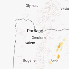
Hail Map for Sunday, August 25, 2013

Number of Impacted Households on 8/25/2013
0
Impacted by 1" or Larger Hail
0
Impacted by 1.75" or Larger Hail
0
Impacted by 2.5" or Larger Hail
Square Miles of Populated Area Impacted on 8/25/2013
0
Impacted by 1" or Larger Hail
0
Impacted by 1.75" or Larger Hail
0
Impacted by 2.5" or Larger Hail


Cities Most Affected by Hail Storms of 8/25/2013
| Hail Size | Demographics of Zip Codes Affected | ||||||
|---|---|---|---|---|---|---|---|
| City | Count | Average | Largest | Pop Density | House Value | Income | Age |
| Bemidji, MN | 1 | 1.75 | 1.75 | 90 | $89k | $36.0k | 33.4 |
| Madras, OR | 1 | 1.75 | 1.75 | 31 | $106k | $34.7k | 37.6 |
Hail and Wind Damage Spotted on 8/25/2013
Filter by Report Type:Hail ReportsWind Reports
Oregon
| Local Time | Report Details |
|---|---|
| 1:30 PM PDT | Quarter sized hail reported near Madras, OR, 26.6 miles NNW of Bend, OR, measured by trained spotter. |
| 1:38 PM PDT | Golf Ball sized hail reported near Madras, OR, 26.6 miles NNW of Bend, OR, golfball hail broke windows and damaged playground equipment at home on north side of madras. |
| 1:42 PM PDT | Quarter sized hail reported near Madras, OR, 25.8 miles NNW of Bend, OR, reported by off duty cwsu employee. |
| 1:42 PM PDT | Estimated wind 70-8 in jefferson county OR, 28.1 miles NNW of Bend, OR |
| 2:30 PM PDT | Quarter sized hail reported near Terrebonne, OR, 15.4 miles WNW of Bend, OR, quarter sized hail at skull hollow campground. |
| 2:45 PM PDT | Quarter sized hail reported near Kent, OR, 65.6 miles N of Bend, OR |
| 2:47 PM PDT | Half Dollar sized hail reported near Prineville, OR, 1.9 miles N of Bend, OR, near intersection of hwy 26 and lone pine rd. heavy rain and 1.25 inch diameter hail covering ground. |
| 2:47 PM PDT | Half Dollar sized hail reported near Prineville, OR, 4.8 miles W of Bend, OR, near intersection of hwy 26 and lone pine rd. heavy rain and 1.25 inch diameter hail covering ground. |
| 2:50 PM PDT | Quarter sized hail reported near Bend, OR, 26.3 miles WSW of Bend, OR, quarter sized hail and heavy rain while driving through tumalo. reported by ke7tmu...relayed by cr-555. |
| 3:13 PM PDT | Small limbs off juniper trees and dime sized hail in north redmon in deschutes county OR, 16.4 miles W of Bend, OR |
| 3:30 PM PDT | Tree limbs and corn blown down. heavy rain reduced visibility to 75 yard in jefferson county OR, 25.5 miles NNW of Bend, OR |
South Dakota
| Local Time | Report Details |
|---|---|
| 5:03 PM MDT | Pea size hail also occurred. hail piled in drifts. wooden swing-set blown apart. in corson county SD, 100.5 miles SSW of Bismarck, ND |
| 6:15 PM MDT | Recorded at the lemmon awos in perkins county SD, 88.3 miles SW of Bismarck, ND |
| 6:52 PM MDT | 1.25 inch hail also reported. trees knocked over... still raining heavily in dewey county SD, 77.6 miles NNW of Pierre, SD |
| 7:00 PM MDT | Resident estimated 60 mph winds as storm passed throug in dewey county SD, 76.5 miles NNW of Pierre, SD |
| 7:35 PM MDT | Estimated 50 to 60 mph wind gusts with some dime size hai in dewey county SD, 76.3 miles N of Pierre, SD |
Minnesota
| Local Time | Report Details |
|---|---|
| 6:20 PM CDT | Quarter sized hail reported near Lake George, MN, 19.6 miles SSW of Bemidji, MN, report relayed from beltrami county em |
| 7:20 PM CDT | Quarter sized hail reported near Bemidji, MN, 1.9 miles E of Bemidji, MN |
| 7:22 PM CDT | Quarter sized hail reported near Bemidji, MN, 0.5 miles N of Bemidji, MN, hail on south end of bemidji |
| 7:30 PM CDT | Golf Ball sized hail reported near Bemidji, MN, 5.2 miles E of Bemidji, MN |
| 7:58 PM CDT | Tree down across county road 39 near county road 22 in beltrami county MN, 17.1 miles ENE of Bemidji, MN |
Washington
| Local Time | Report Details |
|---|---|
| 6:00 PM PDT | Tree limbs approx 4-7 inch diameter down from thunderstorm wind gusts. also reported intersection of kennewick avenue and perry street flooded with 6 inches wate in benton county WA, 40.8 miles WNW of Walla Walla, WA |
| 6:15 PM PDT | Storm damage reported in benton county WA, 51.4 miles WNW of Walla Walla, WA |
| 6:15 PM PDT | Storm damage reported in benton county WA, 52.8 miles WNW of Walla Walla, WA |
| 6:25 PM PDT | Estimated wind gusts to 60 mph...also heavy rain and pea sized hai in benton county WA, 47.9 miles WNW of Walla Walla, WA |
| 6:40 PM PDT | High winds and extensive blowing dust. wind gust estimated 60 mph. pool cover blown off poo in franklin county WA, 36.2 miles NNW of Walla Walla, WA |
| 7:00 PM PDT | Power line knocked down by falling tre in adams county WA, 62.6 miles NW of Walla Walla, WA |
| 7:00 PM PDT | Power pole blown down in adams county WA, 59.3 miles NW of Walla Walla, WA |
| 7:15 PM PDT | Combined report from newspaper and public...as many as 8 large trees down around town. damage sustained to fences and power line in adams county WA, 63.4 miles NNW of Walla Walla, WA |
| 7:15 PM PDT | Three large trees blown down onto road in adams county WA, 63.4 miles NNW of Walla Walla, WA |
| 7:15 PM PDT | Newspaper reported damage to 5 poles holding transmission lines that led to local power outage in grant county WA, 67.8 miles ENE of Yakima, WA |
| 7:15 PM PDT | Power pole blown down in adams county WA, 64.4 miles NNW of Walla Walla, WA |
| 7:55 PM PDT | Two large trees split...one on golf course and one on 5th and sherlock. no damage noted to property. widespread 2-4 inch branches on ground around tow in lincoln county WA, 41.1 miles WSW of Spokane, WA |
| 8:22 PM PDT | Multiple trees down at the lakeview terrace mobile home park. 2 mobile homes damaged due to falling tree in grant county WA, 40.7 miles SE of Omak, WA |
| 8:22 PM PDT | Multiple trees down at the lakeview terrace mobile home park. 2 mobile homes damaged due to falling tree in grant county WA, 40.7 miles SE of Omak, WA |
| 8:22 PM PDT | Multiple trees down at the lakeview terrace mobile home park. 2 mobile homes damaged due to falling tree in lincoln county WA, 45.2 miles SE of Omak, WA |
| 8:25 PM PDT | Several trees down around town. no damage noted to property although utility company reported tree on powerline with 29 customers affecte in lincoln county WA, 34.5 miles W of Spokane, WA |
| 8:26 PM PDT | Fairchild afb asos gust reported of 53 knot in spokane county WA, 11.1 miles WSW of Spokane, WA |
| 8:30 PM PDT | Roof partially torn off by wind at coulee dam casino. damage sustained to casino sign. half of roof reported damaged and water damage from following rai in okanogan county WA, 39.9 miles SE of Omak, WA |
| 8:30 PM PDT | Sherriffs dispatch reports numerous trees down within coulee dam city limits. report includes trees blocking in okanogan county WA, 39.9 miles SE of Omak, WA |
| 8:30 PM PDT | Law enforcement reports numerous trees and power poles down in and around city of grand coulee from gust fron in grant county WA, 40.7 miles SE of Omak, WA |
| 8:30 PM PDT | Large tree knocked down in sherman cemeter in lincoln county WA, 57.1 miles WNW of Spokane, WA |
| 8:30 PM PDT | Large tree knocked down in sherman cemeter in lincoln county WA, 56.6 miles WNW of Spokane, WA |
| 8:30 PM PDT | Sherriffs dispatch reports power transformer and lines down across sr155. road closed for 3.5 hour in okanogan county WA, 39.2 miles SE of Omak, WA |
| 8:35 PM PDT | 62mph wind gust reported at nws offic in spokane county WA, 10.3 miles W of Spokane, WA |
| 8:35 PM PDT | Reports of many trees down in the 9 mile falls area...especially along w charles rd. combination of trees being uprooted and snapped. power outages due to trees on powe in spokane county WA, 11.8 miles NW of Spokane, WA |
| 8:37 PM PDT | Spring canyon raw in lincoln county WA, 43.2 miles SE of Omak, WA |
| 8:40 PM PDT | Greenhouse destroyed on property. debris was spread about 75 feet from where the greenhouse originally was se in lincoln county WA, 22.3 miles WNW of Spokane, WA |
| 8:45 PM PDT | Tree on powerline. 29 customers affecte in lincoln county WA, 34.5 miles W of Spokane, WA |
| 8:45 PM PDT | Large tree uproote in spokane county WA, 9.8 miles NW of Spokane, WA |
| 8:51 PM PDT | Tree on power line. 278 customers affecte in stevens county WA, 24.6 miles NW of Spokane, WA |
| 9:07 PM PDT | Tree on power line. 178 customers affecte in spokane county WA, 16.3 miles N of Spokane, WA |
| 9:09 PM PDT | Tree on power line. 61 customers affecte in stevens county WA, 24 miles NNW of Spokane, WA |
| 9:10 PM PDT | Downed trees caused power outages in pend oreille county WA, 30.7 miles N of Spokane, WA |
| 9:15 PM PDT | Trees knocked down power line in pend oreille county WA, 36.5 miles N of Spokane, WA |
| 9:25 PM PDT | Stevens county emergency manager reports numerous trees down...power outages and damage to property throughout southern stevens count in stevens county WA, 46.1 miles NW of Spokane, WA |
| 9:35 PM PDT | Two foot diameter tree branch snapped and partially blocking roadwa in stevens county WA, 64.9 miles NNW of Spokane, WA |
| 9:35 PM PDT | Two foot diameter tree branch snapped and partially blocking roadwa in stevens county WA, 65.7 miles NNW of Spokane, WA |
| 10:00 PM PDT | Ferry county pud reported a tree down across power lines. power restored to area approx 200a in ferry county WA, 40.2 miles ENE of Omak, WA |
| 10:00 PM PDT | Numerous power outages due to trees on power lines in pend oreille county WA, 71.4 miles N of Spokane, WA |
| 10:30 PM PDT | *** 1 in pend oreille county WA, 78.6 miles NNE of Spokane, WA |
Idaho
| Local Time | Report Details |
|---|---|
| 7:00 PM MDT | Outflow winds knocked down at least 8 power polls.numerous people without powe in twin falls county ID, 0.6 miles ENE of Twin Falls, ID |
| 7:50 PM PDT | Quarter sized hail reported near Fernwood, ID, 61.4 miles SE of Spokane, WA, spotter in fernwood id reported quarter size hail and gusty wind and heavy rain. |
| 9:33 PM PDT | Tree on power line. 41 customers affecte in bonner county ID, 40.2 miles NNE of Spokane, WA |
Nevada
| Local Time | Report Details |
|---|---|
| 6:50 PM PDT | Longnow sagebrush west dri site - elevation 5880 f in white pine county NV, 34 miles SE of Ely, NV |
Montana
| Local Time | Report Details |
|---|---|
| 8:25 PM MDT | Large tree blown over in lake county MT, 37.4 miles S of Whitefish, MT |
| 8:25 PM MDT | Large tree blown over with winds estimated at 60 mp in lake county MT, 37.4 miles S of Whitefish, MT |
| 2:50 AM MDT | Reports by the camels hump lookout in mineral county MT, 64.7 miles WNW of Missoula, MT |
Michigan
| Local Time | Report Details |
|---|---|
| 2:55 AM EDT | Foot diameter pine tree down across wawonowin club road. via tv6. time estimated from rada in marquette county MI, 17.6 miles WSW of Marquette, MI |
| 3:00 AM EDT | Relayed through tv6 news and social media. numerous trees down around ishpeming...especially west and south of town. time estimated from rada in marquette county MI, 17.6 miles WSW of Marquette, MI |
| 3:05 AM EDT | Isolated tree damage around the area of west ishpeming. most tree damage in the immediate area was near the intersection of randall/greenwood/hollyhock streets. largest in marquette county MI, 14.6 miles WSW of Marquette, MI |
| 3:05 AM EDT | 2 trees roughly a foot in diameter fell near the intersection of cr-478 and m28 west of ishpeming. one tree clipped the corner of a mobile home and another fell on a ca in marquette county MI, 17.4 miles WSW of Marquette, MI |
| 3:05 AM EDT | 43 trees uprooted or snapped at wawonowin golf course. some trees were up to around 2 feet in diameter and all fell in the same directio in marquette county MI, 17.4 miles WSW of Marquette, MI |
| 3:10 AM EDT | A few trees uprooted or snapped and braches broken off in the south angeline/salisbury/terrace street area south of ishpeming. one large branch fell on a car...breaking in marquette county MI, 13.7 miles WSW of Marquette, MI |
| 3:15 AM EDT | Large tree down at intersection of m35 and county road mp. time estimated from rada in marquette county MI, 13.6 miles SSW of Marquette, MI |
| 3:25 AM EDT | Part of large tree fell onto wright street near fitch avenue in marquette and narrowly missed a hous in marquette county MI, 1 miles N of Marquette, MI |
| 4:30 AM EDT | Luce county emergency manager reports trees down across northern luce county. more specifically...at the blind sucker campground where a tree fell on a tent...and at mu in luce county MI, 62.2 miles WNW of Sault Sainte Marie, MI |
Connect with Interactive Hail Maps