

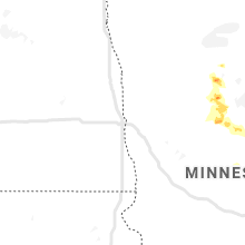
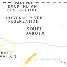
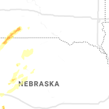
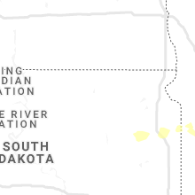
Hail Map for Saturday, August 8, 2020

Number of Impacted Households on 8/8/2020
0
Impacted by 1" or Larger Hail
0
Impacted by 1.75" or Larger Hail
0
Impacted by 2.5" or Larger Hail
Square Miles of Populated Area Impacted on 8/8/2020
0
Impacted by 1" or Larger Hail
0
Impacted by 1.75" or Larger Hail
0
Impacted by 2.5" or Larger Hail


Cities Most Affected by Hail Storms of 8/8/2020
| Hail Size | Demographics of Zip Codes Affected | ||||||
|---|---|---|---|---|---|---|---|
| City | Count | Average | Largest | Pop Density | House Value | Income | Age |
| Rapid City, SD | 6 | 2.88 | 4.50 | 111 | $119k | $47.4k | 44.3 |
| Hemingford, NE | 2 | 2.25 | 2.50 | 1 | $56k | $34.0k | 45.7 |
| Goodland, KS | 2 | 1.75 | 1.75 | 9 | $65k | $33.1k | 41.5 |
| Bird City, KS | 1 | 1.75 | 1.75 | 1 | $43k | $27.5k | 46.6 |
| Tribune, KS | 1 | 1.75 | 1.75 | 1 | $58k | $34.3k | 46.6 |
Hail and Wind Damage Spotted on 8/8/2020
Filter by Report Type:Hail ReportsWind Reports
South Dakota
| Local Time | Report Details |
|---|---|
| 7:39 AM CDT | Storm damage reported in campbell county SD, 73 miles SSE of Bismarck, ND |
| 4:59 PM MDT | Tennis Ball sized hail reported near Rapid City, SD, 15 miles W of Rapid City, SD, ground is white |
| 5:00 PM MDT | Baseball sized hail reported near Rapid City, SD, 14.4 miles W of Rapid City, SD |
| 5:05 PM MDT | Grapefruit sized hail reported near Rapid City, SD, 13.4 miles W of Rapid City, SD |
| 5:10 PM MDT | Softball sized hail reported near Rapid City, SD, 13.4 miles W of Rapid City, SD |
| 5:15 PM MDT | Quarter sized hail reported near Edgemont, SD, 61.3 miles SSW of Rapid City, SD, mainly pea to marble hail with biggest pieces around 1 inch. |
| 5:20 PM MDT | Quarter sized hail reported near Edgemont, SD, 60.3 miles SW of Rapid City, SD, mainly half-inch hail with a few one inch pieces. hail completely covered the ground. |
| 5:30 PM MDT | Golf Ball sized hail reported near Rapid City, SD, 13.4 miles W of Rapid City, SD |
| 5:40 PM MDT | Quarter sized hail reported near Piedmont, SD, 10.7 miles NNW of Rapid City, SD |
| 6:00 PM MDT | Golf Ball sized hail reported near Rapid City, SD, 10.7 miles SSW of Rapid City, SD |
| 6:05 PM MDT | Quarter sized hail reported near Rapid City, SD, 1.3 miles SE of Rapid City, SD |
| 6:33 PM MDT | Storm damage reported in custer county SD, 27.7 miles S of Rapid City, SD |
| 6:36 PM MDT | Storm damage reported in custer county SD, 20.3 miles S of Rapid City, SD |
| 6:37 PM MDT | 637 pm to 645 pm was the hail. peak wind at 637 pm estimated wind of 40 mph at 645 p in custer county SD, 22.9 miles S of Rapid City, SD |
| 6:55 PM MDT | Small branches broken off tree in custer county SD, 38.8 miles S of Rapid City, SD |
| 6:55 PM MDT | Storm damage reported in oglala lakota county SD, 80.9 miles SSE of Rapid City, SD |
| 7:03 PM MDT | Storm damage reported in pennington county SD, 18.2 miles ESE of Rapid City, SD |
| 7:40 PM MDT | Quarter sized hail reported near Scenic, SD, 37.7 miles ESE of Rapid City, SD, few pieces of hail |
| 10:04 PM CDT | Storm damage reported in todd county SD, 41 miles NW of Valentine, NE |
| 10:14 PM CDT | Storm damage reported in todd county SD, 15.8 miles N of Valentine, NE |
| 11:04 PM CDT | Storm damage reported in tripp county SD, 43.1 miles NE of Valentine, NE |
| 11:19 PM CDT | Storm damage reported in tripp county SD, 50.6 miles NE of Valentine, NE |
| 11:59 PM CDT | Storm damage reported in charles mix county SD, 68.7 miles NNW of Oneill, NE |
| 12:14 AM CDT | Storm damage reported in gregory county SD, 41.8 miles N of Oneill, NE |
| 12:15 AM CDT | Storm damage reported in brule county SD, 65.9 miles SE of Pierre, SD |
| 12:24 AM CDT | Storm damage reported in brule county SD, 81.7 miles ESE of Pierre, SD |
| 12:39 AM CDT | Personal weather station ksdplank in aurora county SD, 83.3 miles N of Oneill, NE |
| 12:41 AM CDT | Personal weather station (ksdwessi5 in aurora county SD, 90.7 miles ESE of Pierre, SD |
| 12:54 AM CDT | Storm damage reported in buffalo county SD, 70.4 miles ESE of Pierre, SD |
| 12:57 AM CDT | Branches down with tree debris blown across the street. estimated wind speed of 60 mp in jerauld county SD, 90.6 miles ESE of Pierre, SD |
| 12:59 AM CDT | Storm damage reported in buffalo county SD, 70.4 miles ESE of Pierre, SD |
| 12:59 AM CDT | Personal weather station (ksdmitch21 in davison county SD, 63.5 miles W of Sioux Falls, SD |
| 1:04 AM CDT | Measured wind gust to 65 mp in hanson county SD, 53.7 miles W of Sioux Falls, SD |
| 1:05 AM CDT | Storm damage reported in bon homme county SD, 57 miles NE of Oneill, NE |
| 1:10 AM CDT | Storm damage reported in sanborn county SD, 72.5 miles WNW of Sioux Falls, SD |
| 2:40 AM CDT | Storm damage reported in deuel county SD, 57.8 miles WSW of Montevideo, MN |
Minnesota
| Local Time | Report Details |
|---|---|
| 10:55 AM CDT | Ping Pong Ball sized hail reported near Bemidji, MN, 6 miles WSW of Bemidji, MN |
| 11:07 AM CDT | Quarter sized hail reported near Bemidji, MN, 4.1 miles SSW of Bemidji, MN, near lake plantagenet. |
| 11:08 AM CDT | Quarter sized hail reported near Bemidji, MN, 7.7 miles SSE of Bemidji, MN, hail near lake plantagenet. near the beltrami county line. |
| 11:08 AM CDT | Quarter sized hail reported near Bemidji, MN, 6 miles SSW of Bemidji, MN, hail near lake plantagenet. near the beltrami county line. |
| 11:52 AM CDT | Quarter sized hail reported near Lake George, MN, 17.6 miles SSW of Bemidji, MN, nickel to quarter sized hail for a couple of minutes. |
| 12:11 PM CDT | Ping Pong Ball sized hail reported near Lake George, MN, 18.5 miles S of Bemidji, MN, variable from small marble to a few ping pong ball sized. event ongoing. |
| 12:33 PM CDT | Quarter sized hail reported near Park Rapids, MN, 22.6 miles S of Bemidji, MN, nickel to quarter sized hail. |
| 12:42 PM CDT | Large trees down... uproote in yellow medicine county MN, 32.3 miles WSW of Montevideo, MN |
| 12:43 PM CDT | Awos station kcnb canb in yellow medicine county MN, 32.3 miles WSW of Montevideo, MN |
| 12:55 PM CDT | Report via social medi in lyon county MN, 30 miles SSW of Montevideo, MN |
| 1:09 PM CDT | Large tree toppled on farmstea in lyon county MN, 24.8 miles SSW of Montevideo, MN |
| 1:14 PM CDT | Quarter sized hail reported near Park Rapids, MN, 33.5 miles S of Bemidji, MN, dime to quarter sized hail reported around little sand lake. |
| 1:14 PM CDT | Quarter sized hail reported near Park Rapids, MN, 33.4 miles S of Bemidji, MN, dime to quarter sized hail reported around little sand lake. |
| 1:15 PM CDT | A few were trees were broken down around big sand lake. report and photo posted via social medi in hubbard county MN, 33.5 miles S of Bemidji, MN |
| 1:17 PM CDT | Quarter sized hail reported near Boyd, MN, 15.1 miles WSW of Montevideo, MN, heavy winds and rain with the report. |
| 1:19 PM CDT | Scattered tree limb damage. size unknow in lac qui parle county MN, 14.7 miles WSW of Montevideo, MN |
| 1:28 PM CDT | Picture of large tree down on machine shed... corn damaged. time estimated from rada in yellow medicine county MN, 18.7 miles SSE of Montevideo, MN |
| 1:40 PM CDT | Measured with anemomete in yellow medicine county MN, 9.1 miles SSE of Montevideo, MN |
| 1:47 PM CDT | Quarter sized hail reported near Akeley, MN, 42.3 miles S of Bemidji, MN, a few dime to quatter sized hail in very heavy rain. |
| 1:52 PM CDT | Peak wind measured at the badoura raws station. time estimated based on nearby sensors and radar dat in hubbard county MN, 43 miles S of Bemidji, MN |
| 1:57 PM CDT | Measured 22 inch tree snapped at base off hwy 21 in renville county MN, 15.7 miles SE of Montevideo, MN |
| 1:59 PM CDT | Widespread tree damage up to 44 inches in diameter. power outages and roof damag in yellow medicine county MN, 13.1 miles SE of Montevideo, MN |
| 2:06 PM CDT | Quarter sized hail reported near Backus, MN, 50.3 miles SSE of Bemidji, MN |
| 2:15 PM CDT | Several trees were blown down between granite falls and sacred heart. power lines were also blown down in the city of sacred hear in renville county MN, 21.6 miles ESE of Montevideo, MN |
| 2:20 PM CDT | Large tree fell on a house in renville. earlier report from social media picture. time estimated by rada in renville county MN, 27.3 miles ESE of Montevideo, MN |
| 5:20 PM CDT | Multiply trees and power lines were blown down from southwest of cannon falls... through cannon falls... and to the east of town. there were 3-4 houses that had roof da in goodhue county MN, 37.4 miles SSE of Minneapolis, MN |
| 5:35 PM CDT | From a cwo in goodhue county MN, 44.1 miles SE of Minneapolis, MN |
Georgia
| Local Time | Report Details |
|---|---|
| 1:55 PM EDT | A tree was downed on scotland road at st. mark roa in laurens county GA, 57.5 miles N of Douglas, GA |
| 2:45 PM EDT | A power line was downed on church stree in toombs county GA, 54.1 miles NNE of Douglas, GA |
| 3:42 PM EDT | Two trees were downed on highway 1 near h powell roa in toombs county GA, 45 miles NE of Douglas, GA |
Kansas
| Local Time | Report Details |
|---|---|
| 4:40 PM MDT | Golf Ball sized hail reported near Goodland, KS, 33.8 miles W of Colby, KS, delayed report via social media. quarter to golfball size hail cracked a windshield and left several dents in a vehicle traveling on i-70 east of goodland. photo of the |
| 4:42 PM MDT | Golf Ball sized hail reported near Goodland, KS, 41.8 miles W of Colby, KS, hail up to golf balls. mixed sizes. |
| 4:52 PM MDT | Storm damage reported in sherman county KS, 34.6 miles W of Colby, KS |
| 4:52 PM MDT | A dead tree (still solid)... 12-14 inches in diameter at the base... felled by severe wind around 4:50-4:55 pm md in sherman county KS, 35.7 miles W of Colby, KS |
| 5:00 PM MDT | Quarter sized hail reported near Goodland, KS, 35.2 miles W of Colby, KS, most hail was pea to dime but there was a measured quarter size stone. |
| 6:40 PM CDT | Golf Ball sized hail reported near Bird City, KS, 41.1 miles NW of Colby, KS, facebook photo of hail up to golf ball... mixed sizes in photo. |
| 6:11 PM MDT | Quarter sized hail reported near Tribune, KS, 61.1 miles NW of Garden City, KS |
| 6:17 PM MDT | Ping Pong Ball sized hail reported near Tribune, KS, 58.9 miles NW of Garden City, KS |
| 6:33 PM MDT | Golf Ball sized hail reported near Tribune, KS, 58.9 miles NW of Garden City, KS |
Wisconsin
| Local Time | Report Details |
|---|---|
| 5:45 PM CDT | Measured at red wing airport (krgk in pierce county WI, 46.6 miles SE of Minneapolis, MN |
| 5:55 PM CDT | A few trees and power lines down in the bay city are in pierce county WI, 48.2 miles ESE of Minneapolis, MN |
| 6:08 PM CDT | A large tree was blown down in durand. time is based on rada in pepin county WI, 66.5 miles NNW of La Crosse, WI |
| 7:35 PM CDT | Half Dollar sized hail reported near Holmen, WI, 15.6 miles NNE of La Crosse, WI, reported via social media. |
| 9:06 PM CDT | Quarter sized hail reported near Wisconsin Rapids, WI, 81.1 miles ENE of La Crosse, WI, occurred at 13th and saratoga street. |
| 9:08 PM CDT | Asos also picked up 0.76 inches of rain in 12 minute in wood county WI, 81.1 miles ENE of La Crosse, WI |
| 6:40 AM CDT | Reports of crop damage relayed from the media near dacada in sheboygan county WI, 65.5 miles S of Green Bay, WI |
Nebraska
| Local Time | Report Details |
|---|---|
| 5:04 PM MDT | Quarter sized hail reported near Harrison, NE, 40.8 miles NNW of Scottsbluff, NE |
| 5:51 PM MDT | 53 knot gus in dawes county NE, 75.9 miles NNE of Scottsbluff, NE |
| 6:00 PM MDT | Asos station kcdr chadron airport - cd in dawes county NE, 72.8 miles NNE of Scottsbluff, NE |
| 6:07 PM MDT | Asos station kcdr chadron airport - cd in dawes county NE, 72.8 miles NNE of Scottsbluff, NE |
| 6:21 PM MDT | Hen Egg sized hail reported near Hemingford, NE, 16.3 miles NNE of Scottsbluff, NE |
| 6:22 PM MDT | Mesonet station hrsn1 7 s chadron - kings canyon raws - hr in dawes county NE, 69.1 miles NNE of Scottsbluff, NE |
| 6:26 PM MDT | Tennis Ball sized hail reported near Hemingford, NE, 15.5 miles NNE of Scottsbluff, NE |
| 6:49 PM MDT | Thunderstorm wind gust of 60 mph reported by the sheriffs department in rushville in sheridan county NE, 84.6 miles NE of Scottsbluff, NE |
| 8:06 PM CDT | Quarter sized hail reported near Culbertson, NE, 52.1 miles S of North Platte, NE |
| 7:24 PM MDT | Storm damage reported in cherry county NE, 70.9 miles W of Valentine, NE |
| 9:59 PM CDT | Asos reported 64mph wind gust in cherry county NE, 0.3 miles S of Valentine, NE |
| 10:15 PM CDT | Storm damage reported in todd county SD, 8.8 miles N of Valentine, NE |
| 10:44 PM CDT | Storm chaser reports wind gusts of at least 60 mph in logan county NE, 37.8 miles NNE of North Platte, NE |
| 11:00 PM CDT | Thunderstorm wind gust of 58mph in brown county NE, 49.4 miles ESE of Valentine, NE |
| 11:00 PM CDT | Thunderstorm wind gust of 58mph in brown county NE, 55.7 miles WSW of Oneill, NE |
North Carolina
| Local Time | Report Details |
|---|---|
| 10:42 PM EDT | 53 kt gust at kgsb reporte in wayne county NC, 49.7 miles SE of Raleigh, NC |
Connect with Interactive Hail Maps