

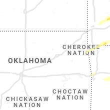
Hail Map for Friday, December 10, 2021

Number of Impacted Households on 12/10/2021
0
Impacted by 1" or Larger Hail
0
Impacted by 1.75" or Larger Hail
0
Impacted by 2.5" or Larger Hail
Square Miles of Populated Area Impacted on 12/10/2021
0
Impacted by 1" or Larger Hail
0
Impacted by 1.75" or Larger Hail
0
Impacted by 2.5" or Larger Hail


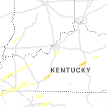


Cities Most Affected by Hail Storms of 12/10/2021
| Hail Size | Demographics of Zip Codes Affected | ||||||
|---|---|---|---|---|---|---|---|
| City | Count | Average | Largest | Pop Density | House Value | Income | Age |
| Bogata, TX | 1 | 2.00 | 2.00 | 12 | $34k | $28.6k | 44.5 |
| Everton, MO | 1 | 1.75 | 1.75 | 19 | $48k | $33.9k | 44.7 |
| Hickman, KY | 1 | 1.75 | 1.75 | 25 | $38k | $22.5k | 40.3 |
Hail and Wind Damage Spotted on 12/10/2021
Filter by Report Type:Hail ReportsWind Reports
States Impacted
Arkansas, Texas, Missouri, Illinois, Oklahoma, Kentucky, Indiana, Tennessee, Ohio, AlabamaArkansas
| Local Time | Report Details |
|---|---|
| 3:35 PM CST | Quarter sized hail reported near Prescott, AR, 28.5 miles ESE of Nashville, AR, corrects previous hail report from 1 ne prescott. law enforcement reports multiple calls regarding quarter sized hail around the city of prescott. |
| 7:12 PM CST | Quarter sized hail reported near Foreman, AR, 39.4 miles WSW of Nashville, AR, quarter size hail reported just east of the ok line and west of foreman. |
| 7:20 PM CST | Quarter sized hail reported near Winthrop, AR, 30 miles WSW of Nashville, AR, quarter size and slightly larger reported near and south of winthrop. |
| 7:25 PM CST | Quarter sized hail reported near Mountain Pine, AR, 52.5 miles WSW of Little Rock, AR |
| 8:00 PM CST | Quarter sized hail reported near Sherwood, AR, 11.7 miles NNE of Little Rock, AR |
| 8:05 PM CST | Trees reported down between foreman and ashdown along highway 3 in little river county AR, 29.7 miles SW of Nashville, AR |
| 8:06 PM CST | Damage to some roofs at white river apartments in dia in jackson county AR, 76.6 miles WNW of Memphis, TN |
| 8:10 PM CST | Half Dollar sized hail reported near Ward, AR, 26.3 miles NE of Little Rock, AR |
| 8:24 PM CST | Little rock afb measured 64 mph wind gus in pulaski county AR, 13.5 miles NE of Little Rock, AR |
| 8:30 PM CST | Quarter sized hail reported near Cabot, AR, 21 miles NE of Little Rock, AR |
| 8:30 PM CST | Quarter sized hail reported near Lonoke, AR, 22.6 miles ENE of Little Rock, AR |
| 8:32 PM CST | Law enforcement reporting trees down just outside the prescott city limits along highway 19 nort in nevada county AR, 26 miles ESE of Nashville, AR |
| 8:35 PM CST | Quarter sized hail reported near Prescott, AR, 28.5 miles ESE of Nashville, AR, law enforcement reports multiple calls regarding quarter sized hail around the city of prescott. |
| 8:45 PM CST | Half Dollar sized hail reported near Blevins, AR, 16.3 miles ESE of Nashville, AR, public report of slightly larger than quarter size hail from a convenience store in blevins. |
| 8:48 PM CST | Quarter sized hail reported near Arkadelphia, AR, 46.1 miles ENE of Nashville, AR |
| 9:03 PM CST | Fire chief reports wind gusts in excess of 58mp in franklin county AR, 35.6 miles ENE of Fort Smith, AR |
| 9:05 PM CST | Storm damage reported in logan county AR, 31.7 miles E of Fort Smith, AR |
| 9:10 PM CST | Storm spotter estimated 60 mph winds and noted power outages in the cit in logan county AR, 40.1 miles E of Fort Smith, AR |
| 9:35 PM CST | Quarter sized hail reported near Prescott, AR, 28.5 miles ESE of Nashville, AR, corrects previous hail report correction from 1 ne prescott. law enforcement reports multiple calls regarding quarter sized hail around the city of prescott. |
| 11:38 PM CST | Small trees down along hwy 278 toward the ouachita county borde in nevada county AR, 42.8 miles SE of Nashville, AR |
Texas
| Local Time | Report Details |
|---|---|
| 4:56 PM CST | Quarter sized hail reported near Farmersville, TX, 38.6 miles NE of Dallas, TX, social media image of measured 1 inch hail. time estimated via radar. |
| 6:20 PM CST | Hen Egg sized hail reported near Bogata, TX, 82.2 miles SE of Atoka, OK, wind gusts estimated at 62 mph and hail from one to up to two inch estimated hail size. |
| 9:45 PM CST | Quarter sized hail reported near Texarkana, TX, 35 miles SSW of Nashville, AR, law enforcement has received numerous calls regarding quarter+ sized hail across the nw portion of texarkana. |
| 10:45 PM CST | Quarter sized hail reported near Texarkana, TX, 35 miles SSW of Nashville, AR, corrects previous hail report from 3 nne nash. law enforcement has received numerous calls regarding quarter+ sized hail across the nw portion of texarkana. |
| 11:48 PM CST | Powerline down on a tree causing the tree to catch on fir in marion county TX, 41.4 miles WNW of Shreveport, LA |
Missouri
| Local Time | Report Details |
|---|---|
| 5:25 PM CST | Unconfirmed report or a roof removed from a home and barn. time estimated from rada in hickory county MO, 47.7 miles N of Springfield, MO |
| 5:40 PM CST | Time estimated from rada in greene county MO, 4.9 miles SSE of Springfield, MO |
| 5:40 PM CST | 2 utility poles snapped. time estimated from rada in greene county MO, 3.7 miles NNE of Springfield, MO |
| 5:52 PM CST | Storm damage reported in greene county MO, 10.4 miles ENE of Springfield, MO |
| 5:59 PM CST | Tree down over roadway on rock quarry and gans roa in boone county MO, 4.5 miles SSE of Columbia, MO |
| 6:00 PM CST | Carport damaged along with several tree in camden county MO, 65.6 miles NNE of Springfield, MO |
| 6:10 PM CST | Trees down from south of richland to south of crocke in pulaski county MO, 49 miles WNW of Salem, MO |
| 6:19 PM CST | Columbia...mo (cou) asos reports gust of 52.0 knots from sw @ 0019z kcou 110032z 20014g22kt 2sm vcts +ra br few024 bkn043 ovc080 14/13 a2943 rmk ao2 pk wnd 22052/0019 r in boone county MO, 11 miles SE of Columbia, MO |
| 6:22 PM CST | Mobile home moved off its foundation near the intersection of highway m and d in wright county MO, 37 miles ENE of Springfield, MO |
| 6:26 PM CST | Osage county sheriffs office reported a roof off a building at county road 503 and highway 133. time estimated from rada in osage county MO, 39 miles SSE of Columbia, MO |
| 6:28 PM CST | Osage county sheriffs office reported numerous trees down along highway 133 into westphalia. time estimated from rada in osage county MO, 39 miles SSE of Columbia, MO |
| 6:30 PM CST | Osage county sheriffs office reported a roof off a business at 674 hwy 63. time estimated from rada in osage county MO, 37.8 miles SSE of Columbia, MO |
| 6:31 PM CST | Tree down blocking both lanes of highway 63 approx 1 mile south of highway 5 in osage county MO, 37.2 miles SSE of Columbia, MO |
| 6:32 PM CST | Tree down on roadway on route f in callaway county MO, 20.2 miles E of Columbia, MO |
| 6:32 PM CST | Callaway county sheriffs office reported a tree down blocking the roadway at state hwy aa and platinum road. time estimated from rada in callaway county MO, 23.2 miles SSE of Columbia, MO |
| 6:32 PM CST | Tree down at the intersection of j and b. time estimated using rada in audrain county MO, 40 miles NE of Columbia, MO |
| 6:34 PM CST | Osage county sheriffs office reported a trampoline was blown into the side of a house. time estimated from rada in osage county MO, 38.3 miles SE of Columbia, MO |
| 6:35 PM CST | Osage county sheriffs office reported home damage along loose creek highway. time estimated from rada in osage county MO, 37.2 miles SE of Columbia, MO |
| 6:35 PM CST | Audrain county dispatch reported a tree down on hwy j near the hwy b intersection. time estimated from rada in audrain county MO, 40 miles NE of Columbia, MO |
| 6:37 PM CST | Callaway county sheriffs office reported a tree down on a house in fulton. time estimated from rada in callaway county MO, 22.2 miles ESE of Columbia, MO |
| 6:37 PM CST | Callaway county sheriffs office reported a downed tree blocking the road at old u.s. hwy 40 and state hwy ff near kingdom city. time estimated from rada in callaway county MO, 20.2 miles E of Columbia, MO |
| 6:42 PM CST | Pike county dispatch reported 4 trees blocking missouri highway 79 near the intersection with route tt. time estimated via rada in pike county MO, 66.3 miles SSE of Kahoka, MO |
| 6:53 PM CST | Gasconade county dispatch reported trees down along hwy 100 between morrison and gasconade. time estimated from rada in gasconade county MO, 44.6 miles ESE of Columbia, MO |
| 6:58 PM CST | Strong winds have brought down tree branche in osage county MO, 47.8 miles NNW of Salem, MO |
| 6:59 PM CST | Golf Ball sized hail reported near Everton, MO, 24.3 miles WNW of Springfield, MO |
| 7:02 PM CST | Measured at the kvih aso in maries county MO, 36.5 miles NNW of Salem, MO |
| 7:06 PM CST | Unknown structural damage near middletown relayed to our office with public reports of a funnel cloud near highway 161 and route in montgomery county MO, 50 miles ENE of Columbia, MO |
| 7:22 PM CST | Franklin county dispatch reported a tree across highway y north of gerald at wheeler road. time estimated from rada in franklin county MO, 55.2 miles NNE of Salem, MO |
| 7:22 PM CST | Large tree down at evergreen loop and 3 oaks road... south of leslie. time estimated from rada in franklin county MO, 51.8 miles NNE of Salem, MO |
| 7:29 PM CST | Quarter sized hail reported near Marthasville, MO, 46.6 miles W of Saint Louis, MO, quarter sized hail reported in the city of marthasville. |
| 7:36 PM CST | Franklin county dispatch reported a large tree blocking the roadway along st. louis inn road wsw of st. clair. time estimated from rada in franklin county MO, 51.8 miles WSW of Saint Louis, MO |
| 7:38 PM CST | Franklin county dispatch reported power lines down at koelling avenue and west springfield avenue in sw union. time estimated from rada in franklin county MO, 46.3 miles WSW of Saint Louis, MO |
| 7:38 PM CST | Franklin county dispatch reported a tree down on hwy 47 at eastview drive south of union. time estimated from rada in franklin county MO, 45.6 miles WSW of Saint Louis, MO |
| 7:40 PM CST | Lincoln county dispatch reported street lights were blown over at 2 locations in winfield. time estimated using rada in lincoln county MO, 38.4 miles NW of Saint Louis, MO |
| 7:40 PM CST | Multiple street lights blown out across the cit in lincoln county MO, 38.9 miles NW of Saint Louis, MO |
| 7:40 PM CST | Building collapse as well as reports of multiple homes damaged and debris in the are in st. charles county MO, 32.5 miles W of Saint Louis, MO |
| 7:40 PM CST | Four homes damaged to the northwest of west branso in stone county MO, 34.8 miles S of Springfield, MO |
| 7:44 PM CST | Franklin county dispatch reported power lines down at denmark road at fairway drive. time estimated from rada in franklin county MO, 41.9 miles WSW of Saint Louis, MO |
| 7:47 PM CST | Franklin county dispatch reported a tree down on thornton road at skyline drive. time estimated from rada in franklin county MO, 32.1 miles WSW of Saint Louis, MO |
| 7:49 PM CST | Dime size hail was also reporte in christian county MO, 18.6 miles S of Springfield, MO |
| 7:50 PM CST | Report of approximately 20 vehicles with debris damage on eastbound 64 east of boone bridg in st. louis county MO, 25.2 miles W of Saint Louis, MO |
| 7:53 PM CST | Franklin county dispatch reported a tree over hogan road in pacific. time estimated from rada in franklin county MO, 33.4 miles WSW of Saint Louis, MO |
| 7:56 PM CST | St. louis/spirit...mo (sus) asos reports gust of 61.0 knots from sw @ 0156z ksus 110156z 22028g61kt 1/2sm r08r/2800vp6000ft +ra fg sq sct026 bkn070 ovc100 17/16 a2947 r in st. louis county MO, 24.5 miles W of Saint Louis, MO |
| 8:00 PM CST | Quarter sized hail reported near Ballwin, MO, 18.6 miles W of Saint Louis, MO, quarter sized hail reported in ballwin. |
| 8:02 PM CST | St. charles...mo (set) asos reports gust of 59.0 knots from w @ 0202z kset 110205z auto 28026g59kt 3/4sm +tsra br bkn029 bkn070 ovc090 17/15 a2945 rmk ao2 pk wnd 28059/ in st. charles county MO, 22.3 miles NW of Saint Louis, MO |
| 8:04 PM CST | Large tree uprooted... fell on to apartment buildin in st. louis county MO, 14 miles WNW of Saint Louis, MO |
| 8:20 PM CST | Fence blown down near chesterfield mal in st. louis county MO, 25.2 miles W of Saint Louis, MO |
| 8:58 PM CST | Ping Pong Ball sized hail reported near Willow Springs, MO, 50 miles SSW of Salem, MO |
| 9:09 PM CST | Franklin county dispatch reported trees and power lines were down along camp mo-val road wsw of union. time estimated from rada in franklin county MO, 50 miles WSW of Saint Louis, MO |
| 9:09 PM CST | Franklin county dispatch reported phone lines down in gerald across west 6th street. time estimated from rada in franklin county MO, 53.8 miles NNE of Salem, MO |
| 9:13 PM CST | Franklin county dispatch reported trees down across north bend loop sw of union. time estimated from rada in franklin county MO, 47.7 miles WSW of Saint Louis, MO |
| 9:15 PM CST | Asos station kcgi cape girardeau m in scott county MO, 5.4 miles SSW of Cape Girardeau, MO |
| 9:28 PM CST | Franklin count dispatch reported power lines down at 75 south main street in st. clair. time estimated from rada in franklin county MO, 46.4 miles WSW of Saint Louis, MO |
| 9:30 PM CST | Franklin county dispatch reported a tree over the roadway at state hwy o and route mm. time estimated from rada in franklin county MO, 38.8 miles WSW of Saint Louis, MO |
| 10:05 PM CST | Reynolds county dispatch reported at least 2 mobile homes destroyed on cr 428... a permanent home with its roof lost on cr 442... power lines down along crs 440... 42 in reynolds county MO, 45.9 miles ESE of Salem, MO |
Illinois
| Local Time | Report Details |
|---|---|
| 6:57 PM CST | Pike county dispatch reported several trees down along county highway 4 near el dara. time estimated using rada in pike county IL, 67.2 miles SE of Kahoka, MO |
| 7:11 PM CST | Pike county dispatch reported 3-4 trees down at this intersection of highways 104 and 107... known as perry junction. illinois dot was called out for removal. time esti in pike county IL, 66.4 miles SE of Kahoka, MO |
| 7:12 PM CST | Transformer blown and power lines down in the city of griggsvill in pike county IL, 72.2 miles SE of Kahoka, MO |
| 7:30 PM CST | Several large tree branches were blown down. estimated wind gusts of 65-75 mp in morgan county IL, 73.7 miles ESE of Kahoka, MO |
| 7:43 PM CST | Green county dispatch reported a hay wagon was blown onto hwy 67 between white hall and carrollton. time estimated using rada in greene county IL, 52.4 miles NNW of Saint Louis, MO |
| 7:45 PM CST | A couch was blown onto hwy 67 at church st. in carrollton. time estimated using rada in greene county IL, 47.7 miles NNW of Saint Louis, MO |
| 7:50 PM CST | Trees and power lines were blown dow in cass county IL, 64.6 miles SSW of Peoria, IL |
| 8:00 PM CST | Greene county dispatch reported power lines blown down at sheffield street and brookley street in greenfield. time estimated using rada in greene county IL, 49.8 miles N of Saint Louis, MO |
| 8:09 PM CST | Jersey county dispatch reported a metal sign and tree limb down across the road at state hwy 16 in jerseyville. time estimated using rada in jersey county IL, 34.7 miles NNW of Saint Louis, MO |
| 8:16 PM CST | Siding was damaged on a house and numerous power poles were blown down along weir road between jacob and wagonseller roa in tazewell county IL, 18.4 miles SSW of Peoria, IL |
| 8:19 PM CST | A farm irrigation unit was flipped into a ditch on goeken road just east of rt 2 in tazewell county IL, 17.7 miles S of Peoria, IL |
| 8:25 PM CST | Measured at the tazewell county eo in tazewell county IL, 11.1 miles SSE of Peoria, IL |
| 8:25 PM CST | Power lines were blown down near rt 4 and cottonwood drive south of the walgreen in sangamon county IL, 70.1 miles S of Peoria, IL |
| 8:29 PM CST | Tractor-trailer overturned on i-270 wb near milepost 7 with cables across the roadwa in madison county IL, 12.2 miles NE of Saint Louis, MO |
| 8:33 PM CST | Macoupin county dispatch reported tree down on hwy 159. time estimated from rada in macoupin county IL, 30.2 miles NNE of Saint Louis, MO |
| 8:33 PM CST | Corrects time on previous tstm wnd gst report from 1 nnw capital airport. asos station kspi springfield capital a in sangamon county IL, 58.3 miles S of Peoria, IL |
| 8:38 PM CST | Power outages have occurre in woodford county IL, 17.2 miles ESE of Peoria, IL |
| 8:40 PM CST | Macoupin county dispatch reported power lines down on school house road east of dorchester road west of staunton. time estimated from rada in macoupin county IL, 32.1 miles NE of Saint Louis, MO |
| 8:50 PM CST | Power poles were snapped along 600 street just west of 2400 avenu in logan county IL, 53.1 miles SSE of Peoria, IL |
| 8:52 PM CST | Asos station kspi springfield capital a in sangamon county IL, 58.3 miles S of Peoria, IL |
| 9:05 PM CST | Bond county dispatch reported a tree down on mount moriah avenue just west of red ball trail. time estimated from rada in montgomery county IL, 52.2 miles ENE of Saint Louis, MO |
| 9:06 PM CST | Bond county dispatch reported tree on hwy 185 just south of coffeen. time estimated from rada in montgomery county IL, 54.1 miles NE of Saint Louis, MO |
| 9:08 PM CST | Montgomery county dispatch reported tree limbs impeding traffic along illinois route 185 near rocky ford road and along happy lane and merry lane. time estimated from r in montgomery county IL, 54.5 miles NE of Saint Louis, MO |
| 9:15 PM CST | Awos station kpnt pontiac airpor in livingston county IL, 53.1 miles ENE of Peoria, IL |
| 9:27 PM CST | Large tree downed. time estimate in grundy county IL, 46 miles SW of Chicago, IL |
| 9:30 PM CST | Roof partially blown off a residential building and a couple trees downe in ford county IL, 65.4 miles ESE of Peoria, IL |
| 9:34 PM CST | Two semis blown on to their sides on i-57 near mile marker 302. time estimated based on rada in kankakee county IL, 62.7 miles SSW of Chicago, IL |
| 9:48 PM CST | Couple large trees downed on the outskirts of tow in iroquois county IL, 69.3 miles S of Chicago, IL |
| 9:50 PM CST | Trees were blown down and power poles were bent along rt 16 just northeast of windso in shelby county IL, 10.8 miles WSW of Mattoon, IL |
| 10:00 PM CST | A semi was blown over near the rural king distribution cente in coles county IL, 2.4 miles WNW of Mattoon, IL |
| 10:16 PM CST | Storm damage reported in champaign county IL, 41.2 miles NNE of Mattoon, IL |
| 10:22 PM CST | Corrects time on previous tstm wnd gst report from lawrenceville airport. asos station klwv lawrenceville a in lawrence county IL, 54.7 miles N of Evansville, IN |
| 10:35 PM CST | Reports of dense styrofoam material scattered across taylor springs as well as neighboring communitie in montgomery county IL, 51.6 miles NE of Saint Louis, MO |
| 10:35 PM CST | Trees and powerlines dow in bond county IL, 43.5 miles NE of Saint Louis, MO |
| 10:38 PM CST | Report of powerlines dow in montgomery county IL, 54.5 miles WSW of Mattoon, IL |
| 10:38 PM CST | Report of a tree dow in montgomery county IL, 50.5 miles WSW of Mattoon, IL |
| 10:51 PM CST | Asos station kmto coles county mem a in coles county IL, 5.7 miles E of Mattoon, IL |
| 10:53 PM CST | Asos station klwv lawrenceville a in lawrence county IL, 54.7 miles N of Evansville, IN |
| 11:06 PM CST | Power lines were blown dow in effingham county IL, 29.6 miles SW of Mattoon, IL |
| 11:31 PM CST | Report of trees down and a damaged machine she in montgomery county IL, 54.1 miles NE of Saint Louis, MO |
| 11:31 PM CST | The dome was blown off the salt storage building at the tazewell county highway departmen in tazewell county IL, 11.1 miles SSE of Peoria, IL |
| 11:35 PM CST | Awos station kprg edgar county a in edgar county IL, 40.6 miles ENE of Mattoon, IL |
| 11:48 PM CST | Measured by carbondale airport aso in jackson county IL, 36.1 miles NNE of Cape Girardeau, MO |
Oklahoma
| Local Time | Report Details |
|---|---|
| 7:40 PM CST | Roof damage to mobile home. time estimated via rada in latimer county OK, 51 miles SW of Fort Smith, AR |
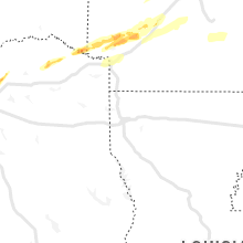
Kentucky
| Local Time | Report Details |
|---|---|
| 8:55 PM CST | Golf Ball sized hail reported near Hickman, KY, 45.6 miles NW of Mc Kenzie, TN |
| 9:24 PM CST | Mesonet station pryb mayfield ky 6 s in graves county KY, 40.7 miles NNW of Mc Kenzie, TN |
| 9:45 PM CST | A mobile home on jackson school road was completely destroyed. a nearby garage was swept off its foundation. possible tornad in marshall county KY, 51.3 miles N of Mc Kenzie, TN |
| 10:40 PM CST | Major damage with buildings leveled... multiple injurie in hopkins county KY, 56.1 miles S of Evansville, IN |
| 10:52 PM CST | Train cars knocked off track near the community of barnsle in hopkins county KY, 49.6 miles S of Evansville, IN |
| 10:57 PM CST | Semi and cars flipped off interstate 69 near earlingto in hopkins county KY, 48.4 miles S of Evansville, IN |
| 11:32 PM CST | Report of large tree down in cloverport on 10 in breckinridge county KY, 51.1 miles WSW of Louisville, KY |
| 11:45 PM CST | Reports of tree down on 99 in breckinridge county KY, 43.6 miles WSW of Louisville, KY |
| 11:49 PM CST | Dispatch reports lots of structural damage to areas north of hartford... k in ohio county KY, 49.3 miles SE of Evansville, IN |
| 1:50 AM EST | Social media pictures shows structural damage to two different buildings... trees blown across old louisville road. time estimated by rada in spencer county KY, 12.4 miles E of Louisville, KY |
| 1:20 AM CST | Corrects previous tstm wnd gst report from 2 nw plano. the bowling green kentucky mesonet measured a wind gust of 75mp in warren county KY, 53.9 miles NNE of Nashville, TN |
| 2:05 AM CST | The munfordville kentucky mesonet station reported a wind gust of 74mp in hart county KY, 49 miles S of Louisville, KY |
| 2:32 AM CST | Downed trees and lines blocking road on herbert turner road just off 31 in barren county KY, 62.4 miles SSW of Louisville, KY |
| 4:30 AM EST | Downed tree blocking roadway near exit 95 on i-7 in madison county KY, 21.7 miles WNW of Irvine, KY |
| 5:17 AM EST | Trees down blocking roadwa in madison county KY, 15.8 miles WNW of Irvine, KY |
| 5:12 AM CST | The bowling green kentucky mesonet measured a wind gust of 75mp in warren county KY, 53.9 miles NNE of Nashville, TN |
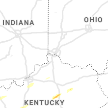
Indiana
| Local Time | Report Details |
|---|---|
| 10:00 PM CST | Multiple power poles and trees down along fathke road in crown point. possible tornado based on subtle tornado debris signature on radar. time estimated by rada in lake county IN, 34 miles SSE of Chicago, IL |
| 10:17 PM CST | Storm damage reported in jasper county IN, 52.9 miles SSE of Chicago, IL |
| 10:23 PM CST | Trees and power lines down near stage coach road. time estimated by rada in porter county IN, 29.3 miles SE of Chicago, IL |
| 10:29 PM CST | Mesonet station in005 2.7 w collegeville (indot in jasper county IN, 68.6 miles SSE of Chicago, IL |
| 10:35 PM CST | Awos station krzl rensselaer airpor in jasper county IN, 68.6 miles SSE of Chicago, IL |
| 10:38 PM CST | Couple large trees downed in the area... as well as several downed medium to large trees scattered about the count in jasper county IN, 56.6 miles SSE of Chicago, IL |
| 11:55 PM EST | Grain bins blow over time estimated from rada in fountain county IN, 61.7 miles WNW of Indianapolis, IN |
| 10:56 PM CST | Mesonet station in048 1.7 e remington (indot in jasper county IN, 81.4 miles SSE of Chicago, IL |
| 12:05 AM EST | Reports of trees down around the county. reports began to come in to dispatch after morristown lost power around midnigh in rush county IN, 32.5 miles ESE of Indianapolis, IN |
| 12:06 AM EST | At least 4 trees down prompted in67 closed between carp and freedom. time estimated from rada in owen county IN, 50.5 miles SW of Indianapolis, IN |
| 12:18 AM EST | Storm damage reported in white county IN, 72.6 miles NNW of Indianapolis, IN |
| 12:25 AM EST | Power lines down. time estimated from rada in montgomery county IN, 39.8 miles WNW of Indianapolis, IN |
| 1:01 AM EST | Large braches and trees down. time estimated from rada in montgomery county IN, 35.1 miles WNW of Indianapolis, IN |
| 1:15 AM EST | Several trees down around northern parts of county... power poles down as well. time estimated from rada in madison county IN, 43.5 miles NNE of Indianapolis, IN |
| 1:15 AM EST | Report from mping: 3-inch tree limbs broken; power poles broke in clinton county IN, 40 miles NNW of Indianapolis, IN |
| 1:30 AM EST | Several trees and some power poles down across mainly northern madison county. time estimated from rada in madison county IN, 47.3 miles NE of Indianapolis, IN |
| 1:36 AM EST | Time estimated by rada in blackford county IN, 45.4 miles SSW of Fort Wayne, IN |
| 1:50 AM EST | Electric poles and some trees down in the county. transformer fire in southern part of the count in johnson county IN, 13.6 miles S of Indianapolis, IN |
| 2:22 AM EST | At 79th and georgetow in marion county IN, 10.4 miles NNW of Indianapolis, IN |
| 2:36 AM EST | Noblesville near the music center relayed via twitte in hamilton county IN, 20.2 miles NE of Indianapolis, IN |
| 2:53 AM EST | Asos station kmie munci in delaware county IN, 51 miles NE of Indianapolis, IN |
| 2:53 AM EST | Asos station kbmg bloomingto in monroe county IN, 49.4 miles SSW of Indianapolis, IN |
| 2:57 AM EST | Report from mping: 1-inch tree limbs broken; shingles blown of in delaware county IN, 49.8 miles NE of Indianapolis, IN |
| 3:34 AM EST | Asos station kgez shelbyvill in shelby county IN, 22.7 miles SE of Indianapolis, IN |
Tennessee
| Local Time | Report Details |
|---|---|
| 10:55 PM CST | Quarter sized hail reported near Rutherford, TN, 26.3 miles W of Mc Kenzie, TN, quarter sized hail near dyer... tennessee... with about 30-40 mph winds. |
| 12:24 AM CST | Clarksville outlaw field asos measured a peak wind gust of 53 knots / 61 mp in montgomery county TN, 47 miles NW of Nashville, TN |
| 1:00 AM CST | Tree down on car on greer st in orange moun in shelby county TN, 6.2 miles ESE of Memphis, TN |
| 1:45 AM CST | Widespread damage to trees and powerlines along highway 412 just west of lexingto in henderson county TN, 33.5 miles S of Mc Kenzie, TN |
| 2:10 AM CST | Storm damage reported in decatur county TN, 40.1 miles SE of Mc Kenzie, TN |
| 2:20 AM CST | Trees down on power lines. power outages reported throughout perry count in perry county TN, 48.4 miles ESE of Mc Kenzie, TN |
| 2:45 AM CST | At least 12 structures on murrell rad and crossroad cowarn road had heavy damage. some people were trapped in the structure in dickson county TN, 35.5 miles WSW of Nashville, TN |
| 3:05 AM CST | Multiple trees were blown down on cars on indian springs rd and pond creek roa in cheatham county TN, 13.5 miles W of Nashville, TN |
| 3:28 AM CST | Nashville intl airport asos measured a peak wind gust of 78 mph. this is the third highest wind gust ever measured at the airpor in davidson county TN, 6.6 miles ESE of Nashville, TN |
| 3:30 AM CST | Numerous trees and power lines were blown down. some structure damage was also reporte in wilson county TN, 14.7 miles ENE of Nashville, TN |
| 3:30 AM CST | Trees and power lines were blown down across nashville area. around 80...000 customers lost powe in davidson county TN, 0.2 miles NNW of Nashville, TN |
| 3:35 AM CST | Due to high winds... multiple streets were blocked by downed trees and power line in sumner county TN, 13.1 miles NE of Nashville, TN |
| 3:48 AM CST | Smyrna airport awos measured a peak wind gust of 51 knots / 59 mp in rutherford county TN, 18.1 miles SE of Nashville, TN |
| 4:45 AM CST | Trees and power lines were blown down in and around livingston and rickma in overton county TN, 82.3 miles E of Nashville, TN |
| 6:35 AM EST | Few trees down just east of the par in scott county TN, 56.9 miles NW of Knoxville, TN |
Ohio
| Local Time | Report Details |
|---|---|
| 2:34 AM EST | Storm damage reported in henry county OH, 56.1 miles ENE of Fort Wayne, IN |
| 3:06 AM EST | Roof blown off and half a building collapsed. time estimated from rada in hardin county OH, 68.3 miles NW of Columbus, OH |
| 6:31 AM EST | Tree down near roa in portage county OH, 27.9 miles SE of Cleveland, OH |
| 6:36 AM EST | Tree down on roa in portage county OH, 47.4 miles SE of Cleveland, OH |
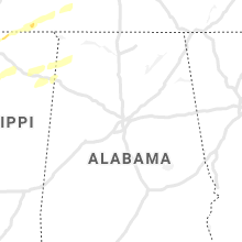
Alabama
| Local Time | Report Details |
|---|---|
| 5:33 AM CST | Emergency manager measured a 59 mph wind gust in downtown florence... a in lauderdale county AL, 0.3 miles W of Florence, AL |
Connect with Interactive Hail Maps