

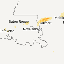
Hail Map for Saturday, February 18, 2012

Number of Impacted Households on 2/18/2012
0
Impacted by 1" or Larger Hail
0
Impacted by 1.75" or Larger Hail
0
Impacted by 2.5" or Larger Hail
Square Miles of Populated Area Impacted on 2/18/2012
0
Impacted by 1" or Larger Hail
0
Impacted by 1.75" or Larger Hail
0
Impacted by 2.5" or Larger Hail


Cities Most Affected by Hail Storms of 2/18/2012
| Hail Size | Demographics of Zip Codes Affected | ||||||
|---|---|---|---|---|---|---|---|
| City | Count | Average | Largest | Pop Density | House Value | Income | Age |
| Perkinston, MS | 1 | 1.75 | 1.75 | 21 | $79k | $36.4k | 36.0 |
| Nashville, GA | 1 | 1.75 | 1.75 | 45 | $73k | $30.9k | 39.4 |
| Lenox, GA | 1 | 1.75 | 1.75 | 31 | $63k | $29.9k | 39.8 |
Hail and Wind Damage Spotted on 2/18/2012
Filter by Report Type:Hail ReportsWind Reports
Louisiana
| Local Time | Report Details |
|---|---|
| 1:45 PM UTC | Tree reported across beglis parkway in sulphu in calcasieu county LA, 24.4 miles ENE of Beaumont, TX |
| 1:50 PM UTC | Power lines blown dow in calcasieu county LA, 25.6 miles ENE of Beaumont, TX |
| 2:00 PM UTC | Storm damage reported in cameron county LA, 38.4 miles E of Beaumont, TX |
| 2:04 PM UTC | Storm damage reported in cameron county LA, 24.5 miles E of Beaumont, TX |
| 3:00 PM UTC | A tree was blown onto a house on shannon drive and power lines were downe in jefferson davis county LA, 38.5 miles W of Lafayette, LA |
| 3:00 PM UTC | Power lines and trees down from ih10 along la hwy 26 to about 3 miles south of ih10 in jefferson davis county LA, 38.5 miles W of Lafayette, LA |
| 3:10 PM UTC | Power poles were blown dow in acadia county LA, 23.5 miles WSW of Lafayette, LA |
| 3:30 PM UTC | Katc estimated 75 mph wind gust on the south side of lafayette with the bow ech in lafayette county LA, 0.8 miles W of Lafayette, LA |
| 3:30 PM UTC | Katc report of estimated 75 mph wind gust on the south side of lafayette with the bow ech in lafayette county LA, 0.8 miles W of Lafayette, LA |
| 3:43 PM UTC | Quarter sized hail reported near Breaux Bridge, LA, 8.1 miles ENE of Lafayette, LA |
| 3:45 PM UTC | Public reported winds of 50 to 60 mph along ambassador caffrey boulevard in lafayette county LA, 0.8 miles W of Lafayette, LA |
| 4:15 PM UTC | Several large limbs snapped. small metal storage sheds displace in st. martin county LA, 11.2 miles E of Lafayette, LA |
| 4:20 PM UTC | Tree blown down along with power lin in iberville county LA, 36.9 miles ENE of Lafayette, LA |
| 4:35 PM UTC | Quarter sized hail reported near Port Allen, LA, 50.8 miles ENE of Lafayette, LA, nickel to quarter sized hail observed by west baton rouge sheriffs in port allen. |
| 4:40 PM UTC | One tree was blown down in the st grarbiel are in iberville county LA, 54.4 miles E of Lafayette, LA |
| 5:10 PM UTC | Sheriffs office reported several trees down in southwest portion of parish in the vicinity of highway 16 and 103 in livingston county LA, 58.2 miles WNW of New Orleans, LA |
| 5:35 PM UTC | Several trees blown down. time based on rada in tangipahoa county LA, 39.9 miles NNW of New Orleans, LA |
| 5:40 PM UTC | Several trees blown down. time based on rada in tangipahoa county LA, 41.4 miles NNW of New Orleans, LA |
| 6:12 PM UTC | Nws survey conducted in abita springs. damage is mainly trees and some powerlines all in one direction. damage is widespread and lacks a clear path. survey results show in st. tammany county LA, 36.4 miles N of New Orleans, LA |
| 6:15 PM UTC | Several trees blown down on cars vicinity of green street north of abita spring in st. tammany county LA, 38.4 miles N of New Orleans, LA |
| 6:15 PM UTC | Sherrifs office reported several trees blown down in north and northeast portion of parish from north of covington to near bus in st. tammany county LA, 40.7 miles N of New Orleans, LA |
| 6:35 PM UTC | Several trees blown dow in tangipahoa county LA, 39.9 miles NNW of New Orleans, LA |
| 6:40 PM UTC | Several trees blown dow in tangipahoa county LA, 41.4 miles NNW of New Orleans, LA |
Mississippi
| Local Time | Report Details |
|---|---|
| 6:35 PM UTC | Several trees and power lines down vicinity of highway 43 and pine grove road in pearl river county MS, 47.3 miles NNE of New Orleans, LA |
| 7:10 PM UTC | Several trees blown over in high thunderstorm wind in stone county MS, 65.9 miles WNW of Mobile, AL |
| 7:10 PM UTC | Golf Ball sized hail reported near Perkinston, MS, 65.6 miles W of Mobile, AL |
| 7:20 PM UTC | Several trees and power lines blown down from thunderstorm wind in stone county MS, 59.8 miles W of Mobile, AL |
| 7:50 PM UTC | Trees down and barns damaged near necaise crossing in hancock county MS, 60.6 miles NE of New Orleans, LA |
Alabama
| Local Time | Report Details |
|---|---|
| 9:24 PM UTC | Trees and power lines blown down by severe thunderstorm wind in escambia county AL, 41.3 miles NE of Mobile, AL |
| 9:24 PM UTC | Trees blown down by thunderstorm winds across interstate 65 between mile markers 54 and 5 in escambia county AL, 42.2 miles NE of Mobile, AL |
| 9:48 PM UTC | Several trees blown down due to severe thunderstorm wind in escambia county AL, 54.2 miles S of Camden, AL |
| 10:36 PM UTC | Measured at uss alabam in gmz630 county AL, 2 miles ESE of Mobile, AL |
| 11:20 PM UTC | Several trees down with some structural damage to a shed and a mobile home. damage was reported in the cc road area on cactus court...just north of elbert in baldwin county AL, 35.1 miles ESE of Mobile, AL |
| 11:40 PM UTC | Damage to a barn...pump house and the back porch of a trailer in baldwin county AL, 41.2 miles ESE of Mobile, AL |
| 12:07 AM UTC | A few trees and power lines down around ozar in dale county AL, 80.4 miles S of Auburn, AL |
| 12:07 AM UTC | Quarter sized hail reported near Ozark, AL, 80.4 miles S of Auburn, AL, quarter inch hail and winds estimated between 40-50 mph |
| 12:28 AM UTC | Large oak trees snapped in half in houston county AL, 82 miles NE of Miramar Beach, FL |
| 1:05 AM UTC | Quarter sized hail reported near Ozark, AL, 80.4 miles S of Auburn, AL, quarter inch hail and winds estimated between 40-50 mph |
| 1:30 AM UTC | Quarter sized hail reported near Ozark, AL, 80.4 miles S of Auburn, AL, quarter inch hail and winds estimated between 40-50 mph |
Florida
| Local Time | Report Details |
|---|---|
| 12:50 AM UTC | Storm spotter estimates gust to 60 mp in walton county FL, 27.5 miles NNE of Miramar Beach, FL |
| 1:31 AM UTC | Several trees down and reports of power outages north of bonifay in holmes county FL, 49.6 miles NE of Miramar Beach, FL |
| 1:34 AM UTC | One tree reported down in jackson county FL, 61.5 miles WNW of Tallahassee, FL |
| 1:40 AM UTC | 2-3 counties down around the c in jackson county FL, 61.5 miles WNW of Tallahassee, FL |
| 1:40 AM UTC | 2-3 trees down around the c in jackson county FL, 61.5 miles WNW of Tallahassee, FL |
| 1:40 AM UTC | 2-3 trees down around the county...along with 1 power line. time estimated in jackson county FL, 61.5 miles WNW of Tallahassee, FL |
| 2:20 AM UTC | Multiple trees and power lines down across the county in bay county FL, 52.9 miles E of Miramar Beach, FL |
Georgia
| Local Time | Report Details |
|---|---|
| 1:15 AM UTC | A few trees were reported down across early county. time and location generalized based on strongest radar velocitie in early county GA, 68.8 miles NNW of Tallahassee, FL |
| 2:01 AM UTC | Several trees and power lines dow in miller county GA, 57 miles NNW of Tallahassee, FL |
| 2:01 AM UTC | Several tress and power line dow in miller county GA, 57 miles NNW of Tallahassee, FL |
| 2:01 AM UTC | Multiple trees and power lines down across the county in mitchell county GA, 53.1 miles N of Tallahassee, FL |
| 2:05 AM UTC | Mobile home near ga hwy 253 in extreme southern baker county...near the decatur county border...was blown over by thunderstorm winds. some other light damage to nearby in baker county GA, 50.5 miles NNW of Tallahassee, FL |
| 2:10 AM UTC | Several trees reported down across the county in baker county GA, 63.8 miles N of Tallahassee, FL |
| 2:10 AM UTC | Tree damage with a tree falling on and damaging an outbuilding. some power lines also brought down near a nearby house. about 12-15 miles out of bainbridge on highway 3 in mitchell county GA, 47.8 miles NNW of Tallahassee, FL |
| 2:18 AM UTC | A tree fell onto a house and a car on homestead avenue. time estimated from rada in dougherty county GA, 71.8 miles N of Tallahassee, FL |
| 2:20 AM UTC | Multiple trees and power lines down across county in decatur county GA, 37 miles NNW of Tallahassee, FL |
| 2:20 AM UTC | Multiple trees and power lines down across the county in grady county GA, 30.4 miles N of Tallahassee, FL |
| 2:20 AM UTC | Trees blown down along yates spring roa in decatur county GA, 40.4 miles NW of Tallahassee, FL |
| 2:20 AM UTC | Tree blown down on leary road near newton road. time estimated from rada in dougherty county GA, 73.2 miles N of Tallahassee, FL |
| 2:23 AM UTC | Trees reported down near black jack rd and power lines down around bainbridg in decatur county GA, 34.8 miles NNW of Tallahassee, FL |
| 2:25 AM UTC | Trees down and an area of power outage reported in dougherty county GA, 78.7 miles W of Douglas, GA |
| 2:25 AM UTC | Trees down with power outages in parts of camilla. time estimated from rada in mitchell county GA, 54.6 miles N of Tallahassee, FL |
| 2:26 AM UTC | County wide trees and power lines down. the majority of these reports are focused on the southern part of the count in mitchell county GA, 54.6 miles N of Tallahassee, FL |
| 2:30 AM UTC | Multiple trees down in worth county GA, 61.5 miles W of Douglas, GA |
| 2:32 AM UTC | Trees and power lines down in pelham. time estimated from rada in mitchell county GA, 48.2 miles N of Tallahassee, FL |
| 2:35 AM UTC | Downed trees blocked highway 133 at nelms road. time estimated from rada in worth county GA, 67.4 miles W of Douglas, GA |
| 2:40 AM UTC | Multiple trees and power lines down across the count in grady county GA, 30.4 miles N of Tallahassee, FL |
| 2:45 AM UTC | Strong winds were accompanied by hail. a trampoline was blown into some tree in thomas county GA, 44.9 miles NNE of Tallahassee, FL |
| 2:45 AM UTC | Tree limbs blown down. time estimated from rada in thomas county GA, 44.9 miles NNE of Tallahassee, FL |
| 2:45 AM UTC | Multiple trees reported dow in worth county GA, 61.5 miles W of Douglas, GA |
| 2:55 AM UTC | Several trees reported down across the county in colquitt county GA, 58.7 miles NNE of Tallahassee, FL |
| 2:58 AM UTC | Trees down with hail also reported. power outage in worth county GA, 52.6 miles W of Douglas, GA |
| 3:18 AM UTC | Golf Ball sized hail reported near Lenox, GA, 40.5 miles WSW of Douglas, GA, golfball sized hail estimated between sparks and lenox. |
| 3:25 AM UTC | Golf Ball sized hail reported near Nashville, GA, 34.1 miles SW of Douglas, GA, location is approximate...hail reported in western berrien county with core of severe thunderstorm. |
| 3:30 AM UTC | Trees down and power outages reporte in cook county GA, 42.1 miles SW of Douglas, GA |
| 3:33 AM UTC | Downed trees reported as cause of power outage in berrien county GA, 31.7 miles SW of Douglas, GA |
| 4:00 AM UTC | The atkinson county department of roads and revenues reported that there was a possible tornado touchdown near cogdell highway on joe neugent road. there were 11 utilit in atkinson county GA, 14.9 miles S of Douglas, GA |
| 4:00 AM UTC | The post office reported that there were 12 utility poles down in pearson and that there was no power for 24 hours. there was also a possible brief tornado touchdown on in atkinson county GA, 14.9 miles S of Douglas, GA |
| 4:05 AM UTC | The tri-county 911 center reported power outages across the southern portion of the count in atkinson county GA, 16.2 miles S of Douglas, GA |
| 4:05 AM UTC | The tri-county 911 center reported power outages across the southern portion of the count in atkinson county GA, 19 miles S of Douglas, GA |
Connect with Interactive Hail Maps