

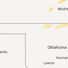
Hail Map for Tuesday, February 28, 2012

Number of Impacted Households on 2/28/2012
0
Impacted by 1" or Larger Hail
0
Impacted by 1.75" or Larger Hail
0
Impacted by 2.5" or Larger Hail
Square Miles of Populated Area Impacted on 2/28/2012
0
Impacted by 1" or Larger Hail
0
Impacted by 1.75" or Larger Hail
0
Impacted by 2.5" or Larger Hail


Cities Most Affected by Hail Storms of 2/28/2012
| Hail Size | Demographics of Zip Codes Affected | ||||||
|---|---|---|---|---|---|---|---|
| City | Count | Average | Largest | Pop Density | House Value | Income | Age |
| Bolivar, MO | 2 | 1.75 | 1.75 | 88 | $86k | $29.9k | 34.5 |
| Cherryvale, KS | 1 | 3.00 | 3.00 | 29 | $36k | $30.7k | 40.4 |
| Kingston, AR | 1 | 2.50 | 2.50 | 5 | $71k | $26.7k | 46.6 |
| Sedgewickville, MO | 1 | 2.50 | 2.50 | 19 | $63k | $37.6k | 39.5 |
| Herington, KS | 1 | 1.75 | 1.75 | 21 | $44k | $31.4k | 42.2 |
| Corning, AR | 1 | 1.75 | 1.75 | 28 | $38k | $23.5k | 42.8 |
| Lamar, MO | 1 | 1.75 | 1.75 | 31 | $64k | $30.9k | 40.8 |
| Parsons, KS | 1 | 1.75 | 1.75 | 72 | $41k | $31.1k | 39.6 |
| Hillsboro, KS | 1 | 1.75 | 1.75 | 26 | $67k | $35.2k | 40.2 |
| Lebanon, MO | 1 | 1.75 | 1.75 | 73 | $75k | $30.1k | 38.8 |
Hail and Wind Damage Spotted on 2/28/2012
Filter by Report Type:Hail ReportsWind Reports
Missouri
| Local Time | Report Details |
|---|---|
| 5:26 PM UTC | Three airport hangers da in cedar county MO, 40.3 miles NW of Springfield, MO |
| 5:48 PM UTC | Golf Ball sized hail reported near Bolivar, MO, 28.4 miles NNW of Springfield, MO, golfball sized hail reported at fairgrounds. |
| 4:15 AM UTC | Storm damage reported in clay county MO, 19.9 miles NNE of Kansas City, MO |
| 4:25 AM UTC | Storm damage reported in clay county MO, 11.6 miles N of Kansas City, MO |
| 4:25 AM UTC | Roof blown off and wall pushed in on building under constructio in clay county MO, 12.3 miles N of Kansas City, MO |
| 4:40 AM UTC | 30 x 50 pole barn blown over. nickel size hai in dekalb county MO, 58.6 miles NNE of Kansas City, MO |
| 4:43 AM UTC | Estimated near river market in jackson county MO, 2.1 miles ENE of Kansas City, MO |
| 4:43 AM UTC | Two mobile homes blown over along with power lines down. 2 people trappe in daviess county MO, 59.7 miles NNE of Kansas City, MO |
| 4:46 AM UTC | Storm damage reported in clay county MO, 6.6 miles NNE of Kansas City, MO |
| 5:09 AM UTC | Golf Ball sized hail reported near Lamar, MO, 59.2 miles WNW of Springfield, MO |
| 5:13 AM UTC | Small hail in livingston county MO, 72.8 miles NE of Kansas City, MO |
| 5:14 AM UTC | Numerous trees and power lines down in lamar...possible damage with possible tornado in barton county MO, 57.8 miles WNW of Springfield, MO |
| 5:15 AM UTC | Possible debris path with structure damage to homes near hwy 71 just north of lamar in barton county MO, 57.8 miles WNW of Springfield, MO |
| 5:26 AM UTC | Windows blown out and barn destroyed in dade county MO, 39.6 miles NW of Springfield, MO |
| 5:28 AM UTC | Jasper county emergency management reports roof damage to a traile in jasper county MO, 61.2 miles W of Springfield, MO |
| 5:36 AM UTC | Storm damage reported in linn county MO, 76.6 miles NW of Columbia, MO |
| 5:48 AM UTC | Emergency management reports roof damage to a trailer and significant damage to a she in hickory county MO, 45.1 miles N of Springfield, MO |
| 5:50 AM UTC | Barn destroyed along hwy 215 on the east side of morrisville. partial roof damage to a house. debris in tree in polk county MO, 20 miles NNW of Springfield, MO |
| 5:50 AM UTC | Golf Ball sized hail reported near Bolivar, MO, 28.4 miles NNW of Springfield, MO |
| 6:05 AM UTC | Houses destroyed and major damage just sw of buffalo. likely a tornado in dallas county MO, 29.9 miles NNE of Springfield, MO |
| 6:12 AM UTC | Several trees blown over along state hwy e...damage to cars and home. powerlines down over hwy 63 north of la plata in adair county MO, 47.4 miles WSW of Kahoka, MO |
| 6:15 AM UTC | Mcdonald county newspaper reported large limbs fell down on power lines which brought down power lines across the county causing power outage in mcdonald county MO, 73.9 miles SW of Springfield, MO |
| 6:19 AM UTC | Structural damage to 15 trailers rolled in laclede county MO, 43.1 miles NNE of Springfield, MO |
| 6:20 AM UTC | Debris structure damage trees down power lines down near hwy 32 and hwy a sw of lebanon...also tracker trailers blown off i-44 from possible tornado in dallas county MO, 30.7 miles NNE of Springfield, MO |
| 6:20 AM UTC | Debris structure damage trees down power lines down near hwy 32 and hwy a sw of lebanon...also tracker trailers blown off i-44 from possible tornado in laclede county MO, 46.3 miles NE of Springfield, MO |
| 6:24 AM UTC | Storm damage reported in lawrence county MO, 28.8 miles SW of Springfield, MO |
| 6:25 AM UTC | Storm damage reported in greene county MO, 11.1 miles WSW of Springfield, MO |
| 6:28 AM UTC | Half Dollar sized hail reported near Lebanon, MO, 47.6 miles NE of Springfield, MO, picture of hail relayed by broadcast media |
| 6:30 AM UTC | Golf Ball sized hail reported near Lebanon, MO, 47.6 miles NE of Springfield, MO |
| 6:30 AM UTC | Machine shed blown over...tree limbs blown down...and fence blown down in shelby county MO, 43.4 miles SW of Kahoka, MO |
| 6:33 AM UTC | Reported by off duty nws meteorologist in greene county MO, 12.1 miles WSW of Springfield, MO |
| 6:40 AM UTC | *** 1 in barry county MO, 47.9 miles SW of Springfield, MO |
| 6:40 AM UTC | Tree down...trailer rolled and damaged to houses off hwy 37 just north of cassville...possible tornado in barry county MO, 47.9 miles SW of Springfield, MO |
| 6:40 AM UTC | Nws employee reports a business sign blown down in greene county MO, 6.8 miles S of Springfield, MO |
| 6:48 AM UTC | Storm damage reported in christian county MO, 11.7 miles S of Springfield, MO |
| 6:50 AM UTC | Large tree blown down at the intersection of nicholas and mckenzie way in christian county MO, 11.7 miles S of Springfield, MO |
| 6:52 AM UTC | Storm damage reported in christian county MO, 11.7 miles S of Springfield, MO |
| 6:52 AM UTC | Storm damage reported in webster county MO, 14.2 miles ESE of Springfield, MO |
| 6:52 AM UTC | Large tree uprooted..concrete wall blown over minor building damage in pulaski county MO, 38.8 miles WNW of Salem, MO |
| 6:55 AM UTC | Ham radio operator reported 60 mph wind gus in christian county MO, 13.8 miles SSE of Springfield, MO |
| 6:59 AM UTC | Storm damage reported in webster county MO, 19.4 miles E of Springfield, MO |
| 7:10 AM UTC | Ham radio operator reported 60 mph wind gust in phelps county MO, 25.1 miles NNW of Salem, MO |
| 7:20 AM UTC | Multiple limbs of 4 to 5 inches dow in stone county MO, 37.9 miles SSW of Springfield, MO |
| 7:23 AM UTC | Roof blown off house and large trees down...possible tornado...near hwy 68 and hwy yy in phelps county MO, 13.3 miles NNW of Salem, MO |
| 7:30 AM UTC | Roof blown off gas station downtown branson possible tornado damage in taney county MO, 39.4 miles S of Springfield, MO |
| 7:35 AM UTC | Mountain grove police department reported power lines dow in wright county MO, 53 miles SW of Salem, MO |
| 7:35 AM UTC | Large billboard blown over onto highway zz just southwest of town...still blocking roa in crawford county MO, 29.9 miles NNE of Salem, MO |
| 7:35 AM UTC | Large tree uprooted and several large sheds blown over on highland drive just north of cub in crawford county MO, 31.2 miles NNE of Salem, MO |
| 7:41 AM UTC | Power lines down in cuba...also tree limbs down over us route 1 in crawford county MO, 30.1 miles NNE of Salem, MO |
| 7:45 AM UTC | Ham radio reported estimated 60 mph wind gust in douglas county MO, 39.2 miles ESE of Springfield, MO |
| 7:45 AM UTC | Ham radio esimated 60 to 70 mph wind gusts and nickel size hai in texas county MO, 32.4 miles SW of Salem, MO |
| 7:50 AM UTC | Large oak tree down blocking hwy 49...one car ran into ditch...no injuries. time estimated from rada in crawford county MO, 21.9 miles ENE of Salem, MO |
| 8:30 AM UTC | Quarter sized hail reported near Pomona, MO, 56.8 miles SSW of Salem, MO |
| 8:38 AM UTC | Storm damage reported in howell county MO, 56 miles SSW of Salem, MO |
| 8:39 AM UTC | Power pole down in howell county MO, 64.9 miles SSW of Salem, MO |
| 8:39 AM UTC | Quarter sized hail reported near Lesterville, MO, 40.6 miles ESE of Salem, MO |
| 8:40 AM UTC | Quarter sized hail reported near Mountain View, MO, 48.9 miles S of Salem, MO, picture of hail relayed by broadcast media |
| 8:45 AM UTC | Tree blown down...unknown size...blocking state hwy c east of annapolis in iron county MO, 51.8 miles ESE of Salem, MO |
| 8:49 AM UTC | Storm damage reported in howell county MO, 64.9 miles SSW of Salem, MO |
| 9:11 AM UTC | *** 1 inj *** 3 homes damaged... at least one with a roof missing and the others with siding removed. another roof removed from barn. several trees downed with diameter in madison county MO, 37.1 miles WNW of Cape Girardeau, MO |
| 9:29 AM UTC | Large tree uprooted..concrete wall blown over minor building damage in pulaski county MO, 38.8 miles WNW of Salem, MO |
| 9:30 AM UTC | Antenna ripped off of home. late repor in wayne county MO, 66.7 miles WSW of Cape Girardeau, MO |
| 9:33 AM UTC | Ping Pong Ball sized hail reported near Ellsinore, MO, 65.2 miles SE of Salem, MO, ping pong size hail along highway v in town. wind gust 30 to 40 mph associated with the storm. |
| 9:41 AM UTC | Tennis Ball sized hail reported near Sedgewickville, MO, 25.1 miles NW of Cape Girardeau, MO, power outages reported as well |
| 9:49 AM UTC | Barn blown away along highway 72 near the bollinger and cape girardeau county lin in bollinger county MO, 22.5 miles NW of Cape Girardeau, MO |
| 9:59 AM UTC | Numerous home stucture damage. widespread trees and powerlines down. damage observed by fire rescue teams and relayed to e0c. possible tornado. no injuries reported at in cape girardeau county MO, 17 miles NW of Cape Girardeau, MO |
| 10:00 AM UTC | *** 1 inj *** emergency manager reporting widespread damage across the northern third of cape giradeau county. manager is asking for no one to enter the area to allow e in cape girardeau county MO, 17 miles NW of Cape Girardeau, MO |
| 10:15 AM UTC | Em reports path of damage between ottawild and brownwood.late repor in stoddard county MO, 27.1 miles SW of Cape Girardeau, MO |
| 10:18 AM UTC | Line of damage from oak ridge to pocahantas missouri. numerous structural and tree damage. power outages. no injures reported at this time. possible tornad in cape girardeau county MO, 17 miles NW of Cape Girardeau, MO |
| 10:30 AM UTC | Numerous power outages with large amount of tree debris. winds estimated 55 mp in stoddard county MO, 42.2 miles SSW of Cape Girardeau, MO |
| 10:41 AM UTC | Golf Ball sized hail reported near Neelyville, MO, 74 miles SW of Cape Girardeau, MO, golf ball size hail reported near the community of neelyville. |
| 10:50 AM UTC | Possible tornado. barn and chicken farm destroyed. house damaged. widespread tree and power line damage along highway 408 near the intersection of hwy 403. late repor in scott county MO, 14 miles S of Cape Girardeau, MO |
| 11:20 AM UTC | *** 1 inj *** emergency manager reporting widespread damage across the northern third of cape giradeau county. manager is asking for no one to enter the area to allow e in cape girardeau county MO, 17 miles NW of Cape Girardeau, MO |
| 11:20 AM UTC | Emergency manager reporting widespread damage across the northern third of cape giradeau county. manager is asking for no one to enter the area to allow emergency servi in cape girardeau county MO, 17 miles NW of Cape Girardeau, MO |
Nebraska
| Local Time | Report Details |
|---|---|
| 10:13 PM UTC | Reported a flipped center pivot unit 3w of the 83/92 junction. tornado report was also in the vicinit in logan county NE, 22.4 miles NNE of North Platte, NE |
| 10:15 PM UTC | Doors blown off of machine shed. delayed repor in logan county NE, 21.9 miles NE of North Platte, NE |
| 12:49 AM UTC | Irrigation pipe tossed and 3000 lb grinder overturned...estimated 60 mph win in valley county NE, 44.5 miles NNW of Grand Island, NE |
| 1:30 AM UTC | Outbuilding taken down by straight line winds at approximately 730 pm cs in nance county NE, 36.4 miles NNE of Grand Island, NE |
Kansas
| Local Time | Report Details |
|---|---|
| 11:30 PM UTC | Damage to out buildings and house. power polls broken and fell on c road between roads 290 and 300. half inch hail was also reporte in jewell county KS, 81 miles WNW of Manhattan, KS |
| 11:38 PM UTC | Possible tornado...2 large trees uprooted...tin wrapped around trees...10x40 metal building destroyed...cars damaged by flying debris...partial barn roof damaged...dela in cloud county KS, 78.9 miles WNW of Manhattan, KS |
| 11:38 PM UTC | Possible tornado...six trees tops sheared off...uprooted tree...limbs across the road in cloud county KS, 80.1 miles WNW of Manhattan, KS |
| 12:02 AM UTC | Some roofs of outbuildings blown off in republic county KS, 73.2 miles NW of Manhattan, KS |
| 12:06 AM UTC | Power poles and trees blown down on the east side of belleville...delayed report in republic county KS, 72.2 miles NW of Manhattan, KS |
| 12:07 AM UTC | Power lines down in bellevill in republic county KS, 72.2 miles NW of Manhattan, KS |
| 12:09 AM UTC | Farm sheds damaged...delayed report in republic county KS, 71.9 miles NW of Manhattan, KS |
| 12:30 AM UTC | Delayed report...spotter estimated 60 mph winds around 630 pm cst...hail broke outside light...size unknown in ottawa county KS, 67.7 miles W of Manhattan, KS |
| 12:30 AM UTC | Damage to out buildings and house. power polls broken and fell on c road between roads 290 and 300. half inch hail was also reporte in jewell county KS, 81 miles WNW of Manhattan, KS |
| 1:15 AM UTC | Also reported dime size hail in washington county KS, 46.7 miles NW of Manhattan, KS |
| 1:17 AM UTC | Trained spotter reported two large post signs twisted 22 degrees and exit 48 on interstate 135 on the north end of moundridge severely fractured. other wooden sign post in mcpherson county KS, 36.8 miles NNW of Wichita, KS |
| 1:20 AM UTC | Storm damage reported in washington county KS, 47 miles NW of Manhattan, KS |
| 1:20 AM UTC | New pivot irrigation system blown over. time of event based on doppler radar imager in kingman county KS, 48 miles W of Wichita, KS |
| 1:22 AM UTC | 2 to 4 inch diameter tree limbs were downe in mcpherson county KS, 34.6 miles N of Wichita, KS |
| 1:28 AM UTC | Golf Ball sized hail reported near Hillsboro, KS, 46.3 miles N of Wichita, KS, storm spotters and deputies reporting golf ball sized hail and winds approx 70mph north of hillsboro on k-15. |
| 1:30 AM UTC | Wind damage to a storage unit located at the intersection of steadman and pennsylvani in harper county KS, 53.2 miles SW of Wichita, KS |
| 1:43 AM UTC | Storm damage reported in sedgwick county KS, 12.9 miles ENE of Wichita, KS |
| 1:43 AM UTC | Report of barn blown into the road in southwestern sumner county. no injuries reporte in sumner county KS, 29 miles S of Wichita, KS |
| 1:50 AM UTC | Power lines blown down. time of occurrence estimated based on doppler radar imager in kingman county KS, 34.8 miles WSW of Wichita, KS |
| 1:50 AM UTC | Reports of minor damage to a in reno county KS, 42.2 miles WNW of Wichita, KS |
| 1:50 AM UTC | Half Dollar sized hail reported near Marion, KS, 48.9 miles NNE of Wichita, KS, amateur radio marion co 1/2 dollar size hail on the north side of marion reservoir. |
| 1:57 AM UTC | Golf Ball sized hail reported near Herington, KS, 42.9 miles SSW of Manhattan, KS, also reported 60 mph wind gusts |
| 2:19 AM UTC | Several power poles were knocked dow in sumner county KS, 37.9 miles S of Wichita, KS |
| 2:20 AM UTC | Quarter sized hail reported near Wilsey, KS, 37.7 miles S of Manhattan, KS |
| 2:20 AM UTC | Ping Pong Ball sized hail reported near Council Grove, KS, 35.8 miles S of Manhattan, KS |
| 2:25 AM UTC | Quarter sized hail reported near Council Grove, KS, 39.9 miles S of Manhattan, KS |
| 2:30 AM UTC | In southeast sumner county the following damage was reported. house lost 2/3 of roof...1 wall bowed out 2 feet...1 large tree uprooted...several power poles blown down in sumner county KS, 41.1 miles SSE of Wichita, KS |
| 2:40 AM UTC | In extreme southeast sumner county the following damage was reported. house lost 2/3 of roof...1 wall bowed out 2 feet...1 large tree uprooted...and a concrete block ga in sumner county KS, 41.1 miles SSE of Wichita, KS |
| 2:43 AM UTC | Storm damage reported in sumner county KS, 43.5 miles SSE of Wichita, KS |
| 2:45 AM UTC | 8-10 inch tree dow in butler county KS, 14 miles E of Wichita, KS |
| 2:46 AM UTC | Storm damage reported in sumner county KS, 41.1 miles SSE of Wichita, KS |
| 2:48 AM UTC | Storm damage reported in cowley county KS, 45.6 miles SSE of Wichita, KS |
| 2:50 AM UTC | 4-5 telephone poles do in cowley county KS, 33.6 miles SSE of Wichita, KS |
| 2:55 AM UTC | The wind gust occurred at 21st road and highway 16 in cowley county KS, 32.5 miles SSE of Wichita, KS |
| 2:55 AM UTC | Quarter sized hail reported near Eskridge, KS, 32.8 miles SE of Manhattan, KS, 35-45 mph winds |
| 2:57 AM UTC | Turnpike gate in west el dorad in butler county KS, 27.6 miles ENE of Wichita, KS |
| 2:59 AM UTC | Storm damage reported in cowley county KS, 40 miles SSE of Wichita, KS |
| 2:59 AM UTC | Storm damage reported in cowley county KS, 35.1 miles SE of Wichita, KS |
| 3:02 AM UTC | Large trees reported down on home. time estimated in wabaunsee county KS, 42.1 miles SE of Manhattan, KS |
| 3:02 AM UTC | At least six power poles were blown down 5 miles east and 2.5 miles south of leon. this damage extended to the northeast of this location by around 2 mile in butler county KS, 33.3 miles E of Wichita, KS |
| 3:03 AM UTC | Heavy structural damage to homes and church building in harveyville due to possible tornado. reports of people trapped in structures. time estimated based on rada in wabaunsee county KS, 42.1 miles SE of Manhattan, KS |
| 3:07 AM UTC | Storm damage reported in cowley county KS, 48.7 miles SE of Wichita, KS |
| 3:07 AM UTC | 4-5 telephone poles do in cowley county KS, 33.6 miles SSE of Wichita, KS |
| 3:19 AM UTC | At 29th and oakley in shawnee county KS, 46.6 miles ESE of Manhattan, KS |
| 3:19 AM UTC | Several power poles were knocked dow in sumner county KS, 37.9 miles S of Wichita, KS |
| 3:20 AM UTC | Power lines in chautauqua county KS, 60.8 miles SE of Wichita, KS |
| 3:22 AM UTC | Hail to 1.5 inch in diameter also accompanied the severe wind gust in chautauqua county KS, 60.8 miles SE of Wichita, KS |
| 3:22 AM UTC | Ping Pong Ball sized hail reported near Cedar Vale, KS, 60.8 miles SE of Wichita, KS, wind gusts to 80 mph accompanied the large hail. |
| 3:30 AM UTC | In southeast sumner county the following damage was reported. house lost 2/3 of roof...1 wall bowed out 2 feet...1 large tree uprooted...several power poles blown down in sumner county KS, 41.1 miles SSE of Wichita, KS |
| 3:30 AM UTC | A house was severely damaged at 80th street and oxford roa in sumner county KS, 37.1 miles SSE of Wichita, KS |
| 3:35 AM UTC | Quarter sized hail reported near Lawrence, KS, 46.2 miles W of Kansas City, MO |
| 3:42 AM UTC | Storm damage reported in greenwood county KS, 46.9 miles WNW of Chanute, KS |
| 3:44 AM UTC | Live tree blown down in douglas county KS, 39.1 miles WSW of Kansas City, MO |
| 3:47 AM UTC | Storm damage reported in douglas county KS, 37.7 miles WSW of Kansas City, MO |
| 3:53 AM UTC | Storm damage reported in osage county KS, 54.7 miles SE of Manhattan, KS |
| 3:56 AM UTC | Storm damage reported in osage county KS, 61.6 miles SE of Manhattan, KS |
| 3:56 AM UTC | A house was destroyed. rescuers were still trying to get a family out of the debris. time of occurrence estimated via doppler rada in wilson county KS, 20.2 miles SW of Chanute, KS |
| 3:57 AM UTC | Estimated 50 to 55 mph with gusts to 60 in leavenworth county KS, 26.7 miles W of Kansas City, MO |
| 3:57 AM UTC | Several large trees 3 feet in diameter blown down. reported both south and northwest of tow in leavenworth county KS, 26.7 miles W of Kansas City, MO |
| 4:02 AM UTC | Quarter sized hail reported near Overbrook, KS, 58.7 miles WSW of Kansas City, MO, estimated wind gusts to 50 mph |
| 4:03 AM UTC | Ping Pong Ball sized hail reported near Independence, KS, 34.3 miles SSW of Chanute, KS |
| 4:03 AM UTC | On south side of tow in montgomery county KS, 34.3 miles SSW of Chanute, KS |
| 4:05 AM UTC | Storm damage reported in johnson county KS, 26.3 miles SW of Kansas City, MO |
| 4:05 AM UTC | Hail to walnut size also occurred and windows were broken out in several home in montgomery county KS, 28.9 miles S of Chanute, KS |
| 4:05 AM UTC | 4 to 5 inch diameter tree limbs downed. windows also broken in homes due to wind driven hai in montgomery county KS, 28.9 miles S of Chanute, KS |
| 4:05 AM UTC | Power pole snapped near bowling alley in tow in montgomery county KS, 28.9 miles S of Chanute, KS |
| 4:05 AM UTC | Delayed report of a roof peeled off of a barn near le roy. time estimated from rada in coffey county KS, 29.1 miles NNW of Chanute, KS |
| 4:05 AM UTC | Delayed report of 2 barns and numerous outbuildings destroyed and vehicle damage near centropolis. time estimated from rada in franklin county KS, 51 miles WSW of Kansas City, MO |
| 4:05 AM UTC | Tea Cup sized hail reported near Cherryvale, KS, 28.9 miles S of Chanute, KS |
| 4:06 AM UTC | Measured at ix in johnson county KS, 25.1 miles SW of Kansas City, MO |
| 4:07 AM UTC | 59 mph wind gusts measured at a weatherlab sit in montgomery county KS, 28.9 miles S of Chanute, KS |
| 4:07 AM UTC | Storm damage reported in montgomery county KS, 28.9 miles S of Chanute, KS |
| 4:19 AM UTC | 62 mph wind gusts measured on weather lab sit in labette county KS, 25.6 miles SSE of Chanute, KS |
| 4:19 AM UTC | Golf Ball sized hail reported near Parsons, KS, 25.6 miles SSE of Chanute, KS |
| 4:20 AM UTC | *** 3 inj *** emergency manager reported 3 trailers blown over. one had a resident that sustained serious injuries. two other minor injuries were rep in labette county KS, 34.6 miles SSE of Chanute, KS |
| 4:21 AM UTC | Metal roofing of an apartment rolled u in leavenworth county KS, 25.1 miles WSW of Kansas City, MO |
| 4:22 AM UTC | Storm damage reported in neosho county KS, 16.5 miles SE of Chanute, KS |
| 4:22 AM UTC | Several reports of damage across labette county and some injuries. specifics uknown at this tim in labette county KS, 25.6 miles SSE of Chanute, KS |
| 4:22 AM UTC | Several reports of damage across labette county and some injuries. specifics unknown at this tim in labette county KS, 25.6 miles SSE of Chanute, KS |
| 4:23 AM UTC | Storm damage reported in labette county KS, 25.6 miles SSE of Chanute, KS |
| 4:23 AM UTC | Ping Pong Ball sized hail reported near Parsons, KS, 25.2 miles SSE of Chanute, KS |
| 4:24 AM UTC | Pea sized hail and heavy rain also reported in leavenworth county KS, 25.1 miles WSW of Kansas City, MO |
| 4:24 AM UTC | Several shingles removed from a hous in leavenworth county KS, 18.5 miles WSW of Kansas City, MO |
| 4:30 AM UTC | Emergency management reports two barns destroyed and one with significant damag in cherokee county KS, 34.6 miles SE of Chanute, KS |
| 4:33 AM UTC | Storm damage reported in crawford county KS, 33.1 miles SE of Chanute, KS |
| 4:36 AM UTC | Two out buildings destroyed with one having its foundation anchors pulled ou in crawford county KS, 33.8 miles SE of Chanute, KS |
| 4:36 AM UTC | Emergency management reports six large wood high voltage power polls down and damage to a bar in cherokee county KS, 35.5 miles SE of Chanute, KS |
| 4:36 AM UTC | Half Dollar sized hail reported near McCune, KS, 33.1 miles SE of Chanute, KS |
| 4:37 AM UTC | Storm damage reported in cherokee county KS, 38.7 miles SE of Chanute, KS |
| 4:42 AM UTC | Douglas ave in wyandotte county KS, 10.7 miles W of Kansas City, MO |
| 4:42 AM UTC | Quarter sized hail reported near Pittsburg, KS, 45.6 miles ESE of Chanute, KS |
| 4:44 AM UTC | Emergency manager reports damage to in crawford county KS, 44.3 miles ESE of Chanute, KS |
| 4:48 AM UTC | Storm damage reported in crawford county KS, 44.3 miles ESE of Chanute, KS |
| 4:48 AM UTC | Storm damage reported in crawford county KS, 44.4 miles ESE of Chanute, KS |
| 4:52 AM UTC | Storm damage reported in crawford county KS, 33 miles SE of Chanute, KS |
| 4:52 AM UTC | Six inch diameter tree limb down at intersection of third and w in crawford county KS, 33 miles SE of Chanute, KS |
| 4:55 AM UTC | Structural damage and lots of trees down near 200th and 510th street southwest of pittsburg...possible tornado damage in crawford county KS, 44.5 miles ESE of Chanute, KS |
| 4:55 AM UTC | Three tall wooden power poles snapped at the base on s 260th st one mile north of e 530th ave. heavy structural damage to house at same locatio in crawford county KS, 48.4 miles ESE of Chanute, KS |
| 4:58 AM UTC | A national weather service storm survey determined that straight-line winds of 100 to 120 miles per hour occured near pittsburg kansas...creating a one mile path of dam in crawford county KS, 45.3 miles ESE of Chanute, KS |
| 4:58 AM UTC | Local emergency manger reported a one mile path of damage from centennial drive and highway 160 to the northeast across the southern portions of the city of pittsburg k in crawford county KS, 45.3 miles ESE of Chanute, KS |
| 4:58 AM UTC | Several trees uproote in crawford county KS, 45.3 miles ESE of Chanute, KS |
| 5:21 AM UTC | Storm damage reported in cherokee county KS, 54.2 miles SE of Chanute, KS |
Oklahoma
| Local Time | Report Details |
|---|---|
| 1:45 AM UTC | Storm damage reported in alfalfa county OK, 61.5 miles ENE of Woodward, OK |
| 2:45 AM UTC | Estimated 70-80 mph gust in kay county OK, 52.9 miles S of Wichita, KS |
| 2:45 AM UTC | Quarter sized hail reported near Braman, OK, 52.9 miles S of Wichita, KS |
| 4:24 AM UTC | 5th wheel trailer overturned and damage to carport just north of dewe in washington county OK, 46.3 miles N of Tulsa, OK |
| 4:25 AM UTC | Tree limbs and large signs blown down and other debris in streets around tow in washington county OK, 41.4 miles N of Tulsa, OK |
| 4:30 AM UTC | Semi blown off roadway into center median. driver transported to hospital with injurie in washington county OK, 33.1 miles N of Tulsa, OK |
| 5:00 AM UTC | 58 mph measured gust at vinita mesonet in craig county OK, 62.3 miles SSE of Chanute, KS |
| 5:00 AM UTC | Near 31st street and memorial...large signs damaged and destroye in tulsa county OK, 5.9 miles ESE of Tulsa, OK |
| 5:30 AM UTC | Tree blown down. also some tree limbs downe in mayes county OK, 39.2 miles ENE of Tulsa, OK |
| 5:30 AM UTC | Roof damage and grill lifted off patio 2 miles east of miami on highway 1 in ottawa county OK, 65.4 miles SSE of Chanute, KS |
| 5:46 AM UTC | Storm damage reported in delaware county OK, 70.2 miles ENE of Tulsa, OK |
| 5:50 AM UTC | Storm damage reported in ottawa county OK, 73.6 miles SSE of Chanute, KS |
| 6:32 AM UTC | Estimated wind gust 60 mph on south side of city in cherokee county OK, 47.1 miles NW of Fort Smith, AR |
Indiana
| Local Time | Report Details |
|---|---|
| 5:13 AM UTC | Quarter sized hail reported near Wadesville, IN, 15 miles NW of Evansville, IN |
Arkansas
| Local Time | Report Details |
|---|---|
| 6:22 AM UTC | Large tree blown down across road on east side of tow in benton county AR, 72.9 miles N of Fort Smith, AR |
| 6:37 AM UTC | 30 inch dia tree blown dow in benton county AR, 67.7 miles SW of Springfield, MO |
| 7:21 AM UTC | Estimated wind gusts to 60 mph and hail. hail size unknow in washington county AR, 48.8 miles NNE of Fort Smith, AR |
| 8:00 AM UTC | Ping Pong Ball sized hail reported near Huntsville, AR, 66.6 miles NE of Fort Smith, AR |
| 8:08 AM UTC | Ping Pong Ball sized hail reported near Huntsville, AR, 58.7 miles NE of Fort Smith, AR |
| 8:14 AM UTC | Ping Pong Ball sized hail reported near Huntsville, AR, 66.6 miles NE of Fort Smith, AR |
| 8:20 AM UTC | Tennis Ball sized hail reported near Kingston, AR, 68.4 miles NE of Fort Smith, AR, relayed by knwa |
| 9:00 AM UTC | Half Dollar sized hail reported near Mountain Home, AR, 78.4 miles SE of Springfield, MO |
| 9:25 AM UTC | Quarter sized hail reported near Norfork, AR, 88.9 miles SE of Springfield, MO, hail ranged in size from penny to quarter. |
| 9:25 AM UTC | Quarter sized hail reported near Viola, AR, 88.8 miles SSW of Salem, MO |
| 10:10 AM UTC | Some tree debris was on local roadways. a wall cloud was reported as the storm went b in sharp county AR, 91.5 miles S of Salem, MO |
| 10:30 AM UTC | Quarter sized hail reported near Ravenden Springs, AR, 93.1 miles S of Salem, MO |
| 10:44 AM UTC | Quarter sized hail reported near Pocahontas, AR, 93.5 miles SSE of Salem, MO |
| 10:50 AM UTC | Quarter sized hail reported near Pocahontas, AR, 94.8 miles SSE of Salem, MO |
| 11:00 AM UTC | Golf Ball sized hail reported near Corning, AR, 85.7 miles SW of Cape Girardeau, MO, spotter mentioned hail could have been bigger. |
| 11:15 AM UTC | Siding and metal roof damage to a house. trees uprooted along hwys 141 and 90. barn damaged in area in clay county AR, 81.5 miles SW of Cape Girardeau, MO |
Kentucky
| Local Time | Report Details |
|---|---|
| 7:42 AM UTC | Tree down on udel branch roa in johnson county KY, 58.5 miles ENE of Irvine, KY |
| 7:56 AM UTC | Tree down on morning branch road. time estimated from rada in johnson county KY, 65.6 miles ENE of Irvine, KY |
| 11:16 AM UTC | Power pole snapped and laying across a mobile home. individuals trapped inside. wind gusts estimated 60 mph. no injuries reported at this tim in ballard county KY, 35.5 miles ESE of Cape Girardeau, MO |
| 11:18 AM UTC | Late report...possible tornado. damage path between bandana and ragsdale. 1 mobile home and 1 farm destroyed near bandana. 1 mobile home destoryed in ragsdale along osc in ballard county KY, 33 miles ESE of Cape Girardeau, MO |
| 11:20 AM UTC | *** 5 inj *** mobile home destoryed along ogden landing road. late report.update...a mix of 6 homes/mobile homes damaged/destoryed. 5 injuries reported with 1 seriou in mccracken county KY, 37.4 miles ESE of Cape Girardeau, MO |
| 11:20 AM UTC | Mobile home destoryed along ogden landing road. late repor in mccracken county KY, 37.4 miles ESE of Cape Girardeau, MO |
| 11:20 AM UTC | Mobile home destoryed along ogden landing road. late repor in mccracken county KY, 47 miles ESE of Cape Girardeau, MO |
| 11:40 AM UTC | A few barns and a machine shed blown down. porch blown off of hom in ballard county KY, 30.5 miles ESE of Cape Girardeau, MO |
Illinois
| Local Time | Report Details |
|---|---|
| 8:35 AM UTC | Roof damage to a barn reported in brushy mound township south of carlinville in macoupin county IL, 46.2 miles NNE of Saint Louis, MO |
| 8:35 AM UTC | Roof damage and sheds blown down in between womac and barnett east of carlinville in macoupin county IL, 50.6 miles NNE of Saint Louis, MO |
| 10:22 AM UTC | Quarter sized hail reported near Carbondale, IL, 31 miles NE of Cape Girardeau, MO, quarter size hail. power outages reported in the area. |
| 10:30 AM UTC | Market street has solid garage destoryed. trees down. damage is in a path along the street. late repor in williamson county IL, 44.4 miles NE of Cape Girardeau, MO |
| 10:36 AM UTC | Widespread power outages reporte in williamson county IL, 43.1 miles NE of Cape Girardeau, MO |
| 10:43 AM UTC | Possible tornado. power flashes south of marion illinois appears to be electrical transformers blowing u in williamson county IL, 43.1 miles NE of Cape Girardeau, MO |
| 10:56 AM UTC | Electrical transformers flashing west of harrisburg. possible tornad in saline county IL, 59.1 miles ENE of Cape Girardeau, MO |
| 11:03 AM UTC | Possible tornado damage north and west of mounds and near exit 8 along interstate 57. spotter had a cross arm ripped off a railroad sign and missled through his vehcile in pulaski county IL, 23.2 miles SE of Cape Girardeau, MO |
| 11:06 AM UTC | Widespread trees and power lines down. numerous homes and one church damaged. late repor in gallatin county IL, 39.9 miles WSW of Evansville, IN |
| 11:18 AM UTC | Highway 45 is closed south of the communit in saline county IL, 56.3 miles WSW of Evansville, IN |
| 11:25 AM UTC | 60 plus mph winds reported and dime size hail in massac county IL, 45.3 miles E of Cape Girardeau, MO |
Connect with Interactive Hail Maps