

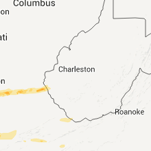
Hail Map for Wednesday, February 29, 2012

Number of Impacted Households on 2/29/2012
0
Impacted by 1" or Larger Hail
0
Impacted by 1.75" or Larger Hail
0
Impacted by 2.5" or Larger Hail
Square Miles of Populated Area Impacted on 2/29/2012
0
Impacted by 1" or Larger Hail
0
Impacted by 1.75" or Larger Hail
0
Impacted by 2.5" or Larger Hail


Cities Most Affected by Hail Storms of 2/29/2012
| Hail Size | Demographics of Zip Codes Affected | ||||||
|---|---|---|---|---|---|---|---|
| City | Count | Average | Largest | Pop Density | House Value | Income | Age |
| West Liberty, KY | 1 | 2.00 | 2.00 | 34 | $59k | $22.0k | 38.6 |
| Eubank, KY | 1 | 1.75 | 1.75 | 61 | $60k | $25.4k | 40.4 |
| Leitchfield, KY | 1 | 1.75 | 1.75 | 86 | $68k | $27.9k | 38.5 |
| Louisa, KY | 1 | 1.75 | 1.75 | 58 | $58k | $22.5k | 39.8 |
| Coeburn, VA | 1 | 1.75 | 1.75 | 45 | $59k | $25.0k | 39.0 |
| Maryville, TN | 1 | 1.75 | 1.75 | 329 | $118k | $45.3k | 43.2 |
| Richmond, KY | 1 | 1.75 | 1.75 | 202 | $99k | $32.4k | 32.5 |
| Andersonville, TN | 1 | 1.75 | 1.75 | 110 | $101k | $36.9k | 43.5 |
| Centertown, KY | 1 | 1.75 | 1.75 | 19 | $44k | $36.4k | 38.1 |
Hail and Wind Damage Spotted on 2/29/2012
Filter by Report Type:Hail ReportsWind Reports
States Impacted
Indiana, Kentucky, Arkansas, West Virginia, Tennessee, Virginia, Mississippi, Alabama, Ohio, North CarolinaIndiana
| Local Time | Report Details |
|---|---|
| 12:00 PM UTC | Numerous trees down along highway 6 in warrick county IN, 9.2 miles ESE of Evansville, IN |
| 12:52 PM UTC | Storm damage reported in crawford county IN, 40 miles WNW of Louisville, KY |
| 1:22 PM UTC | Minor roof damge at charlestown middle school in clark county IN, 32 miles N of Louisville, KY |
| 1:35 PM UTC | Tree down on phone lines on antioch rd. corrected earlier ls in switzerland county IN, 26.4 miles SW of Cincinnati, OH |
| 2:38 PM UTC | Tree fell over us 421 blocking highway in jefferson county IN, 50.6 miles WSW of Cincinnati, OH |
Kentucky
| Local Time | Report Details |
|---|---|
| 12:00 PM UTC | *** 2 inj *** possible tornado...near ellis park 3 to 4 river homes destroyed with 2 injures reported. late repor in henderson county KY, 7.4 miles S of Evansville, IN |
| 12:03 PM UTC | Dime size hail reported with the stor in henderson county KY, 13.7 miles SSE of Evansville, IN |
| 12:14 PM UTC | Storm damage reported in henderson county KY, 16.9 miles SE of Evansville, IN |
| 12:40 PM UTC | A roof off of a garage on poole road. 1 metal frame structure damaged. 2 outbuildings blew onto highway 41.six mature trees down on south end of madisonvill in hopkins county KY, 44 miles S of Evansville, IN |
| 12:40 PM UTC | Severly damaged home blocking roadwa in hopkins county KY, 44 miles S of Evansville, IN |
| 12:45 PM UTC | Quarter sized hail reported near Slaughters, KY, 34 miles S of Evansville, IN, quarter size hail reported. |
| 12:57 PM UTC | Quarter sized hail reported near Bremen, KY, 46.5 miles SSE of Evansville, IN, quarter size hail reported in the community. |
| 1:08 PM UTC | Golf Ball sized hail reported near Centertown, KY, 49.3 miles SE of Evansville, IN |
| 1:08 PM UTC | A spotter estimated 60 mph winds. several large branches were downe in meade county KY, 28.1 miles W of Louisville, KY |
| 1:20 PM UTC | Metal shed destroye in meade county KY, 25.3 miles W of Louisville, KY |
| 1:28 PM UTC | Quarter sized hail reported near Benton, KY, 50.2 miles N of Mc Kenzie, TN |
| 1:35 PM UTC | Storm damage reported in oldham county KY, 29.9 miles NNE of Louisville, KY |
| 1:45 PM UTC | Limbs down across ky 339 in oldham county KY, 31.2 miles NNE of Louisville, KY |
| 2:15 PM UTC | Tree down on antioch rd in boone county KY, 17.9 miles SW of Cincinnati, OH |
| 2:26 PM UTC | Golf Ball sized hail reported near Leitchfield, KY, 47 miles SW of Louisville, KY |
| 2:49 PM UTC | Reports of roofs blown off homes and 1 schoo in muhlenberg county KY, 56.9 miles SSE of Evansville, IN |
| 2:50 PM UTC | Quarter sized hail reported near Big Clifty, KY, 38.4 miles SW of Louisville, KY |
| 3:08 PM UTC | Factory damage near intersection of ky 210 and us 31 in hardin county KY, 21 miles SSW of Louisville, KY |
| 3:08 PM UTC | Power lines and house damaged along ky 210 in hardin county KY, 21 miles SSW of Louisville, KY |
| 3:08 PM UTC | Harry owen trucking heavily damaged near ky 21 in hardin county KY, 22.4 miles SSW of Louisville, KY |
| 3:08 PM UTC | Mobile homes destroyed along ky 210 in hardin county KY, 22.4 miles SSW of Louisville, KY |
| 3:10 PM UTC | Quarter sized hail reported near Almo, KY, 43.6 miles NNE of Mc Kenzie, TN |
| 3:24 PM UTC | Quarter sized hail reported near Hardin, KY, 49.4 miles NNE of Mc Kenzie, TN |
| 3:36 PM UTC | Quarter sized hail reported near Cadiz, KY, 64 miles NE of Mc Kenzie, TN, quarter size hail at the airport. |
| 3:36 PM UTC | Quarter sized hail reported near Cadiz, KY, 54.7 miles NNE of Mc Kenzie, TN, quarter size hail in the lbl area. |
| 3:40 PM UTC | Quarter sized hail reported near Cadiz, KY, 64 miles NE of Mc Kenzie, TN, quarter size hail in cadiz. |
| 3:48 PM UTC | Ping Pong Ball sized hail reported near Hopkinsville, KY, 68.2 miles NW of Nashville, TN |
| 3:51 PM UTC | Storm damage reported in christian county KY, 68.2 miles NW of Nashville, TN |
| 3:52 PM UTC | House damaged in grayson county KY, 44 miles SW of Louisville, KY |
| 3:53 PM UTC | Quarter sized hail reported near Big Clifty, KY, 38.4 miles SW of Louisville, KY |
| 3:55 PM UTC | Storm damage reported in trigg county KY, 64 miles NE of Mc Kenzie, TN |
| 3:58 PM UTC | 3 or 4 houses and barns heavily damaged along ky 224 in grayson county KY, 44 miles SW of Louisville, KY |
| 3:58 PM UTC | Woman trapped in damaged home in grayson county KY, 42.2 miles SSW of Louisville, KY |
| 4:05 PM UTC | Also...dime size hail reported in christian county KY, 61.5 miles NW of Nashville, TN |
| 4:14 PM UTC | Quarter sized hail reported near Cadiz, KY, 64 miles NE of Mc Kenzie, TN |
| 4:18 PM UTC | House destroyed on stiles ford road and ky 210 in larue county KY, 28.8 miles S of Louisville, KY |
| 4:18 PM UTC | Several homes destroyed near us highway 31e in larue county KY, 30.2 miles S of Louisville, KY |
| 4:28 PM UTC | Quarter sized hail reported near Hopkinsville, KY, 61.5 miles NW of Nashville, TN |
| 4:30 PM UTC | Large barn on the ground with tin rolled up on adjacent roof. appears to be straight line wind in christian county KY, 61.5 miles NW of Nashville, TN |
| 4:40 PM UTC | Ping Pong Ball sized hail reported near Hopkinsville, KY, 62.6 miles NW of Nashville, TN |
| 5:44 PM UTC | Golf Ball sized hail reported near Richmond, KY, 18.5 miles WNW of Irvine, KY |
| 6:05 PM UTC | Quarter sized hail reported near Clay City, KY, 11.3 miles NNE of Irvine, KY, time estimated from radar. |
| 6:05 PM UTC | Large limbs down on snow creek. time estimated from rada in powell county KY, 11.3 miles NNE of Irvine, KY |
| 6:11 PM UTC | Quarter sized hail reported near Hardyville, KY, 52.3 miles S of Louisville, KY |
| 6:15 PM UTC | Quarter sized hail reported near Stanton, KY, 12.1 miles NNE of Irvine, KY, time estimated from radar. |
| 6:15 PM UTC | At wku campus in warren county KY, 58.4 miles NNE of Nashville, TN |
| 6:15 PM UTC | Large tree limbs down on mill knob. time estimated from rada in powell county KY, 12.1 miles NNE of Irvine, KY |
| 6:35 PM UTC | Trees down onto hwy 1693. time estimated from rada in menifee county KY, 31.7 miles ENE of Irvine, KY |
| 6:45 PM UTC | Large limbs down in yard. limbs damaged guttering on home. damaged occurred on tabernacle r in morgan county KY, 32.1 miles ENE of Irvine, KY |
| 6:45 PM UTC | Wind caved in a 12 foot section of one in morgan county KY, 32.1 miles ENE of Irvine, KY |
| 6:45 PM UTC | Quarter sized hail reported near Center, KY, 61.9 miles S of Louisville, KY |
| 6:45 PM UTC | Half Dollar sized hail reported near Ezel, KY, 32.1 miles ENE of Irvine, KY, occurred on tabernacle road. large limbs down. limbs damaged guttering on home. |
| 6:45 PM UTC | Ping Pong Ball sized hail reported near West Liberty, KY, 39.2 miles ENE of Irvine, KY |
| 6:47 PM UTC | Hen Egg sized hail reported near West Liberty, KY, 41.2 miles ENE of Irvine, KY |
| 6:50 PM UTC | On hw in morgan county KY, 40.8 miles ENE of Irvine, KY |
| 6:57 PM UTC | Trees down and structures damaged on 191 and 460 west just outside of west libert in morgan county KY, 41.2 miles ENE of Irvine, KY |
| 7:15 PM UTC | Quarter sized hail reported near Flatgap, KY, 61.2 miles ENE of Irvine, KY |
| 7:18 PM UTC | Quarter sized hail reported near West Liberty, KY, 56 miles ENE of Irvine, KY |
| 7:19 PM UTC | Tree down across hwy 1010. employee estimated diameter between 1.5 and 2 feet. time estimated from rada in wolfe county KY, 30.6 miles ENE of Irvine, KY |
| 7:22 PM UTC | Quarter sized hail reported near Columbia, KY, 68.9 miles SSE of Louisville, KY, one inch hail reported along state highway 127 5 miles northwest of russell springs. also...debris was reported. radar indicated a very strong circulation. |
| 7:23 PM UTC | Trees and power lines down and debris in roads just north of sycamore fla in russell county KY, 69.5 miles SW of Irvine, KY |
| 7:23 PM UTC | Mobile homes destroyed along with some barns and homes on patty ridge roa in russell county KY, 68.1 miles SSE of Louisville, KY |
| 7:27 PM UTC | Ping Pong Ball sized hail reported near Adams, KY, 63.5 miles WSW of Charleston, WV |
| 7:35 PM UTC | Golf Ball sized hail reported near Louisa, KY, 57.1 miles WSW of Charleston, WV |
| 7:40 PM UTC | Quarter sized hail reported near Liberty, KY, 57.1 miles SW of Irvine, KY, saw wall cloud...estimated 65 mph winds |
| 7:41 PM UTC | Quarter sized hail reported near Dunnville, KY, 65.1 miles WSW of Irvine, KY, south fork ridge road 910 near ky 127 |
| 7:41 PM UTC | Quarter sized hail reported near Liberty, KY, 61 miles WSW of Irvine, KY, south fork ridge road 910 near ky 127 |
| 7:41 PM UTC | Trees...power lines down near webbs crossroad near ky 127 in russell county KY, 69.3 miles SSE of Louisville, KY |
| 7:42 PM UTC | Tree down on udel branch road. time estimated from rada in johnson county KY, 58.5 miles ENE of Irvine, KY |
| 7:42 PM UTC | Roof partially blown off home. porch damaged. occurred on robinson branch roa in breathitt county KY, 34.7 miles ESE of Irvine, KY |
| 7:42 PM UTC | Golf Ball sized hail reported near Eubank, KY, 42.6 miles SW of Irvine, KY, powerlines also down near faubush |
| 7:48 PM UTC | Large limbs were blown down. time of event is estimated from rada in breathitt county KY, 43.8 miles E of Irvine, KY |
| 7:50 PM UTC | Trees down and large tree branches down. wind estimated at 60 mph. possible funnel cloud spotte in mccreary county KY, 62.1 miles NNW of Knoxville, TN |
| 7:50 PM UTC | Playground equipment located at the science hill park was uprooted and moved behind the daycare center which is approximatley a football field distance awa in pulaski county KY, 51.2 miles SW of Irvine, KY |
| 7:50 PM UTC | Several structures damaged behind valley view super market. time estimated by rada in pulaski county KY, 51.2 miles SW of Irvine, KY |
| 7:55 PM UTC | Trees down and some structure damage at the intersection of hwy 39 and hwy 635. time estimated by rada in pulaski county KY, 47.8 miles SW of Irvine, KY |
| 7:56 PM UTC | Tree down on morning branch road. time estimated from rada in johnson county KY, 65.6 miles ENE of Irvine, KY |
| 8:00 PM UTC | Tree blown over onto a bridge on highway 1502 just south of waldo. some damage occurred to bridge. time based on rada in magoffin county KY, 55.2 miles E of Irvine, KY |
| 8:03 PM UTC | Large limbs were blown down. time of event is estimated from rada in floyd county KY, 62.8 miles E of Irvine, KY |
| 8:05 PM UTC | Tree down in nancy. time estimated from rada in pulaski county KY, 60.9 miles SW of Irvine, KY |
| 8:30 PM UTC | Multiple trees down. time estimated from rada in wayne county KY, 76.3 miles NW of Knoxville, TN |
| 8:40 PM UTC | Trees down on highway 167 just north of mount pisgah. time estimated from rada in wayne county KY, 69.2 miles NW of Knoxville, TN |
| 8:42 PM UTC | Trees down on highway 19 in pike county KY, 63 miles N of Bristol, TN |
| 8:52 PM UTC | Trees down on highway 194 and highway 63 in pike county KY, 63.4 miles N of Bristol, TN |
| 8:52 PM UTC | Trees down on route 2059 in woodma in pike county KY, 61.5 miles SSW of Charleston, WV |
| 9:01 PM UTC | Trees and large limbs dow in whitley county KY, 62.6 miles SSW of Irvine, KY |
| 9:01 PM UTC | Structural damage. occurred between 401 and 431 p in whitley county KY, 55.5 miles NNW of Knoxville, TN |
| 9:18 PM UTC | Some minor damage to out buildings and trees down along hwy 26. time estimated from rada in whitley county KY, 57.5 miles NNW of Knoxville, TN |
| 9:31 PM UTC | Quarter sized hail reported near Barbourville, KY, 57.5 miles S of Irvine, KY |
| 9:44 PM UTC | Trees down on dorton branch roa in bell county KY, 56.5 miles NNE of Knoxville, TN |
| 9:46 PM UTC | Trees down on petes blossom road. time estimated from rada in bell county KY, 57.5 miles NNE of Knoxville, TN |
| 9:48 PM UTC | Trees down on cow fork road. time estimated from rada in bell county KY, 59.3 miles SSE of Irvine, KY |
| 9:50 PM UTC | Quarter sized hail reported near Pineville, KY, 56.5 miles NNE of Knoxville, TN |
| 9:52 PM UTC | Trees down along u.s. highway 119. time estimated from rada in bell county KY, 60 miles NNE of Knoxville, TN |
| 10:00 PM UTC | Tree fell across road on hwy 229 approx. 1/4 to 1/2 mile north of us 25 e in knox county. tree is partially blocking north bound lane of roa in knox county KY, 57.5 miles S of Irvine, KY |
Arkansas
| Local Time | Report Details |
|---|---|
| 12:20 PM UTC | Half Dollar sized hail reported near Pocahontas, AR, 89.3 miles NW of Memphis, TN |
| 12:50 PM UTC | Ping Pong Ball sized hail reported near Strawberry, AR, 92.1 miles NW of Memphis, TN |
| 1:01 PM UTC | Quarter sized hail reported near Greenway, AR, 76.2 miles SSW of Cape Girardeau, MO |
| 8:40 PM UTC | Quarter sized hail reported near Wilmot, AR, 27.9 miles NE of Bastrop, LA |
West Virginia
| Local Time | Report Details |
|---|---|
| 8:20 PM UTC | Tree down across route 3 just north of the town of seth in boone county WV, 16.6 miles S of Charleston, WV |
| 8:20 PM UTC | Trees down along route 17 in the powell creek area in wyoming county WV, 26.3 miles SSW of Charleston, WV |
| 8:53 PM UTC | Tree down in hookersville in pocahontas county WV, 45.2 miles E of Charleston, WV |
| 9:00 PM UTC | Trees and powerlines down along saturday road just east of ansted in fayette county WV, 32.7 miles ESE of Charleston, WV |
| 9:00 PM UTC | Trees down at several locations along route 49 in mingo county in mingo county WV, 58.2 miles SW of Charleston, WV |
| 9:10 PM UTC | Tree and powerlines down along possum creek road about 7 miles east of ansted around the hico area in fayette county WV, 32.7 miles ESE of Charleston, WV |
| 9:10 PM UTC | Tree down in craigsville in nicholas county WV, 53.7 miles E of Charleston, WV |
| 9:12 PM UTC | Tree down in mount nebo in nicholas county WV, 44.1 miles ESE of Charleston, WV |
| 9:16 PM UTC | One tree down over a power line on leonard-cordova road in greenbrier county WV, 57 miles NNW of Roanoke, VA |
| 9:30 PM UTC | Several outbuildings damaged... one barn with half the roof blown off. numerous trees uprooted or damage in wood county WV, 57.7 miles N of Charleston, WV |
| 9:30 PM UTC | 10 inch diameter pine treetop snapped off in fayette county WV, 36.9 miles SE of Charleston, WV |
| 9:30 PM UTC | *** 1 inj *** one tree fell on a truck traveling past the coal mine on anjean in greenbrier county WV, 58 miles ESE of Charleston, WV |
| 9:53 PM UTC | One tree down on brush road in greenbrier county WV, 46.6 miles NNW of Roanoke, VA |
| 10:16 PM UTC | One tree down over a power line on leonard-cordova road in greenbrier county WV, 57 miles NNW of Roanoke, VA |
| 10:25 PM UTC | Several trees down in the big draft are in greenbrier county WV, 37.3 miles NNW of Roanoke, VA |
| 10:34 PM UTC | Several trees down in union and the surrounding are in monroe county WV, 38.8 miles WNW of Roanoke, VA |
| 11:20 PM UTC | One tree down on gardner road near spanishburg in mercer county WV, 65.3 miles W of Roanoke, VA |
| 11:25 PM UTC | Two trees knocked down power lines on pine grove road in mercer county WV, 60 miles WNW of Roanoke, VA |
| 11:30 PM UTC | One tree down on unity road near athens in mercer county WV, 60.3 miles W of Roanoke, VA |
| 4:15 AM UTC | Quarter sized hail reported near Coalton, WV, 6.4 miles WSW of Elkins, WV |
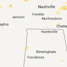
Tennessee
| Local Time | Report Details |
|---|---|
| 8:50 PM UTC | Windows were reportedly blown out of buildings in downtown carthage in smith county TN, 47.3 miles E of Nashville, TN |
| 9:19 PM UTC | 60-70 mph winds reported north of cookeville along with pea-sized hai in putnam county TN, 71.2 miles E of Nashville, TN |
| 9:24 PM UTC | Barn suffered roof damage. also half dollar sized hail was reporte in overton county TN, 77.3 miles E of Nashville, TN |
| 9:30 PM UTC | Trees down. quarter sized hail also reporte in putnam county TN, 71.2 miles E of Nashville, TN |
| 9:30 PM UTC | Quarter sized hail reported near Cookeville, TN, 76.7 miles E of Nashville, TN, quarter sized hail reported in hickman county |
| 9:35 PM UTC | Quarter sized hail reported near Livingston, TN, 81.8 miles E of Nashville, TN, hail reported near highway 84 and industrial drive |
| 9:46 PM UTC | Ping Pong Ball sized hail reported near Jamestown, TN, 65.5 miles WNW of Knoxville, TN |
| 9:49 PM UTC | Storm damage reported in de kalb county TN, 55.5 miles ESE of Nashville, TN |
| 9:50 PM UTC | Structural damage on arrowhead drive. trees down on dogwood circle and highland drive. possible tornad in de kalb county TN, 54.9 miles ESE of Nashville, TN |
| 9:50 PM UTC | Reports of several trees down near banner springs road...a fallen tree damaged a garage in the same are in fentress county TN, 65.1 miles WNW of Knoxville, TN |
| 9:54 PM UTC | *** 1 fatal *** roof damage with numerous trees down along holiday haven rd. one fatality reported. possible tornad in de kalb county TN, 59.9 miles E of Nashville, TN |
| 9:54 PM UTC | Roof damage with numerous trees down along holiday haven rd. report of a person trapped in a home. possible tornad in de kalb county TN, 59.9 miles E of Nashville, TN |
| 10:10 PM UTC | Barn destroyed along linville r in white county TN, 69.8 miles N of Chattanooga, TN |
| 10:30 PM UTC | 60 to 100 trees blown down. possible tornad in cumberland county TN, 65.4 miles W of Knoxville, TN |
| 10:30 PM UTC | Three homes destroyed...tractor trailer flipped in the rinnie community. area currently inaccessible due to the damage. possible tornad in cumberland county TN, 65.4 miles W of Knoxville, TN |
| 10:34 PM UTC | *** 1 fatal *** cumberland county ema reported one fatality and an unknown number of injuries in the rinnie community. possible tornad in cumberland county TN, 65.1 miles W of Knoxville, TN |
| 10:34 PM UTC | *** 2 fatal *** cumberland county ema reported two fatalities and an unknown number of injuries in the rinnie community. possible tornad in cumberland county TN, 65.1 miles W of Knoxville, TN |
| 10:45 PM UTC | Several trees dow in campbell county TN, 20.9 miles NNW of Knoxville, TN |
| 10:45 PM UTC | Golf Ball sized hail reported near Andersonville, TN, 20.9 miles NNW of Knoxville, TN |
| 11:50 PM UTC | Several trees dow in rhea county TN, 35 miles NNE of Chattanooga, TN |
| 11:50 PM UTC | Quarter sized hail reported near Dayton, TN, 35 miles NNE of Chattanooga, TN |
| 12:35 AM UTC | Possible tornado. several trees down and structural damage to storage buildin in loudon county TN, 25.9 miles SW of Knoxville, TN |
| 12:40 AM UTC | Golf Ball sized hail reported near Maryville, TN, 18.9 miles S of Knoxville, TN |
| 12:50 AM UTC | Quarter sized hail reported near Townsend, TN, 21.6 miles SSE of Knoxville, TN |
| 12:55 AM UTC | Ping Pong Ball sized hail reported near Sevierville, TN, 22.6 miles SE of Knoxville, TN |
| 1:02 AM UTC | Dispatch reported a few trees down on waldens creek roa in sevier county TN, 22.5 miles SE of Knoxville, TN |
| 8:00 AM UTC | Few trees dow in cocke county TN, 39 miles ESE of Knoxville, TN |
Virginia
| Local Time | Report Details |
|---|---|
| 9:48 PM UTC | Trees down on route 687 near the intersection of route 603 in bath county VA, 53.9 miles N of Roanoke, VA |
| 10:30 PM UTC | Trees down in douthat state park and along state route 62 in bath county VA, 43.9 miles N of Roanoke, VA |
| 11:10 PM UTC | Golf Ball sized hail reported near Coeburn, VA, 30.4 miles NW of Bristol, TN |
| 11:10 PM UTC | Several trees dow in wise county VA, 30.4 miles NW of Bristol, TN |
| 11:50 PM UTC | Trees and power lines dow in russell county VA, 23.3 miles NNE of Bristol, TN |
| 12:15 AM UTC | Trees and power lines dow in wise county VA, 28.3 miles NNW of Bristol, TN |
| 12:28 AM UTC | Quarter sized hail reported near Chilhowie, VA, 34.4 miles ENE of Bristol, TN, observed on white top road north of konnarock |
| 12:30 AM UTC | Quarter sized hail reported near Lebanon, VA, 23.3 miles NNE of Bristol, TN |
| 5:00 AM UTC | Trees and power lines dow in scott county VA, 21.3 miles W of Bristol, TN |
| 5:05 AM UTC | Possible tornado damage in gate city. a few trees and power lines down. a small storage shed was destroyed and a mobile home roof was blown of in scott county VA, 20.2 miles W of Bristol, TN |
| 5:05 AM UTC | Possible tornado damage in gate city. a few trees and power lines down. a small storage shed was blown into the road at benton dr and starnes st. a porch collapsed that in scott county VA, 21.3 miles W of Bristol, TN |
| 5:35 AM UTC | Several trees dow in scott county VA, 20.2 miles W of Bristol, TN |
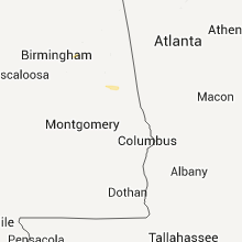
Mississippi
| Local Time | Report Details |
|---|---|
| 9:50 PM UTC | Roof off of a house on old highway 49. powerlines down at town water pumping statio in humphreys county MS, 69.8 miles NNW of Jackson, MS |
| 10:21 PM UTC | 60 mph gusts estimated by trained spotter/ham radio operator in monroe county MS, 42 miles NNE of Starkville, MS |
| 10:21 PM UTC | Multiple trees down in smithville in monroe county MS, 47.9 miles NNE of Starkville, MS |
| 10:29 PM UTC | 60 mph gusts estimated by trained spotter/ham radio operator in monroe county MS, 42 miles NNE of Starkville, MS |
| 10:30 PM UTC | Multiple trees down across the town in monroe county MS, 41.2 miles NE of Starkville, MS |
| 10:45 PM UTC | Numerous large limbs were dow in carroll county MS, 55 miles W of Starkville, MS |
Alabama
| Local Time | Report Details |
|---|---|
| 10:38 PM UTC | Five out of the eight light poles at the sulligent high school baseball field were either collapsed or bent in half. one home near the school received significant damag in lamar county AL, 49 miles NE of Starkville, MS |
| 10:38 PM UTC | Numerous trees down across the northern half of the county blocking many roadways. one tree down on house...no injuries. shingles blown off several homes in downtown su in lamar county AL, 49 miles NE of Starkville, MS |
Ohio
| Local Time | Report Details |
|---|---|
| 12:26 AM UTC | Quarter sized hail reported near Ravenna, OH, 33.4 miles SE of Cleveland, OH |
North Carolina
| Local Time | Report Details |
|---|---|
| 1:15 AM UTC | Numerous trees down in burnsville and parts of the town without power. first report from spotter then confirmed with count in yancey county NC, 46.5 miles S of Bristol, TN |
| 1:25 AM UTC | Trees down to the west of interstate 40 blocking the road and one large tree down across one lane of east bound interstate 4 in haywood county NC, 56.6 miles ESE of Knoxville, TN |
| 1:25 AM UTC | A tree on a house on pigeon street and powerlines down across much of haywood count in haywood county NC, 49 miles NNW of Greenville, SC |
Connect with Interactive Hail Maps