

Hail Map for Thursday, January 21, 2016

Number of Impacted Households on 1/21/2016
0
Impacted by 1" or Larger Hail
0
Impacted by 1.75" or Larger Hail
0
Impacted by 2.5" or Larger Hail
Square Miles of Populated Area Impacted on 1/21/2016
0
Impacted by 1" or Larger Hail
0
Impacted by 1.75" or Larger Hail
0
Impacted by 2.5" or Larger Hail


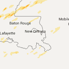

Cities Most Affected by Hail Storms of 1/21/2016
| Hail Size | Demographics of Zip Codes Affected | ||||||
|---|---|---|---|---|---|---|---|
| City | Count | Average | Largest | Pop Density | House Value | Income | Age |
| Amite, LA | 3 | 1.83 | 2.00 | 76 | $72k | $29.7k | 37.4 |
| Deridder, LA | 2 | 1.88 | 2.00 | 59 | $67k | $33.2k | 36.8 |
| Kentwood, LA | 1 | 2.75 | 2.75 | 44 | $75k | $27.9k | 38.1 |
| Bon Wier, TX | 1 | 1.75 | 1.75 | 12 | $38k | $23.3k | 39.4 |
| Meadville, MS | 1 | 1.75 | 1.75 | 12 | $49k | $26.5k | 43.2 |
| Franklinton, LA | 1 | 1.75 | 1.75 | 60 | $64k | $24.3k | 38.0 |
Hail and Wind Damage Spotted on 1/21/2016
Filter by Report Type:Hail ReportsWind Reports
Louisiana
| Local Time | Report Details |
|---|---|
| 6:52 AM CST | Quarter sized hail reported near Hall Summit, LA, 34.9 miles SE of Shreveport, LA, quarter sized hail reported |
| 7:29 AM CST | Quarter sized hail reported near Sicily Island, LA, 65.7 miles SSE of Bastrop, LA |
| 1:45 PM CST | Half Dollar sized hail reported near Deridder, LA, 58.6 miles NNE of Beaumont, TX, storm chaser reports half dollar size hail along hwy 171 and hwy 26 in deridder. |
| 1:45 PM CST | Golf Ball sized hail reported near Deridder, LA, 58.6 miles NNE of Beaumont, TX, beauregard sheriff reports golf ball size hail in de ridder. |
| 1:45 PM CST | Hen Egg sized hail reported near Deridder, LA, 57.3 miles NNE of Beaumont, TX, public sent in photo of hail south of deridder with ruler for measurement. time estimated by radar |
| 1:48 PM CST | Public posted photo to facebook of a tree down in simpson... la. time estimated by rada in vernon county LA, 91 miles NNE of Beaumont, TX |
| 2:23 PM CST | Quarter sized hail reported near Pitkin, LA, 74.1 miles NW of Lafayette, LA, public posted a photo on facebook of quarter size hail near pitkin |
| 2:30 PM CST | Quarter sized hail reported near Deridder, LA, 58.6 miles NNE of Beaumont, TX, report from sheriffs office. |
| 2:44 PM CST | Half Dollar sized hail reported near Moreauville, LA, 61.6 miles N of Lafayette, LA, public posted facebook photo of half dollar size hail in bordelonville. time estimated by radar |
| 2:45 PM CST | Quarter sized hail reported near Marksville, LA, 62.7 miles N of Lafayette, LA, report from sheriffs office. |
| 2:51 PM CST | Quarter sized hail reported near Jonesville, LA, 80 miles S of Bastrop, LA |
| 2:52 PM CST | Half Dollar sized hail reported near Glenmora, LA, 61.6 miles NNW of Lafayette, LA, public posted a photo of hail at plainview high school in glenmora. time estimated by radar. |
| 3:10 PM CST | Rapides sheriff reports powerlines down... a cattle trailer thrown across a road and sheds destroyed along powell dr in ball... l in rapides county LA, 85.9 miles NNW of Lafayette, LA |
| 3:11 PM CST | Media relayed a report of skirting being blown off of a mobile home at 297 dynasty ln in opelousas. time estimated by rada in st. landry county LA, 21 miles N of Lafayette, LA |
| 4:45 PM CST | Porch roof blown off a home at louisiana highway 447 and courtney road in walke in livingston county LA, 59.7 miles NW of New Orleans, LA |
| 4:50 PM CST | Tree reported blown down onto eastbound side of us highway 190 on the four mile bridge near lotti in pointe coupee county LA, 32.5 miles NE of Lafayette, LA |
| 4:55 PM CST | Quarter sized hail reported near Slaughter, LA, 62.1 miles NE of Lafayette, LA |
| 5:35 PM CST | Golf Ball sized hail reported near Amite, LA, 59.4 miles NNW of New Orleans, LA, golf ball size hail reported in amite. picture relayed through broadcast media. event time estimated by radar. |
| 5:45 PM CST | Golf Ball sized hail reported near Amite, LA, 58.1 miles NNW of New Orleans, LA, golf ball size hail reported 3 miles east of amite. picture relayed through broadcast media. event time estimated by radar. |
| 5:54 PM CST | Hen Egg sized hail reported near Amite, LA, 55.7 miles NNW of New Orleans, LA, two inch hail reported about 10 miles east of amite. several small hail reports near independence. report relayed through tangipahoa parish emergency manager. |
| 5:55 PM CST | Baseball sized hail reported near Kentwood, LA, 61.3 miles NNW of New Orleans, LA, baseball size hail reported near wilmer. event time estimated by radar. photo relayed by broadcast media. |
| 6:03 PM CST | Quarter sized hail reported near Kentwood, LA, 68.6 miles NNW of New Orleans, LA, quarter size hail reported 4 miles southeast of kentwood. report relayed by broadcast media. |
| 6:05 PM CST | Golf Ball sized hail reported near Franklinton, LA, 61.9 miles N of New Orleans, LA, golfball sized hail in downtown franklinton. |
Mississippi
| Local Time | Report Details |
|---|---|
| 8:11 AM CST | Quarter sized hail reported near Fayette, MS, 65.7 miles SW of Jackson, MS, hail up to quarter size along hwy 553 covering the ground. |
| 8:11 AM CST | Quarter sized hail reported near Fayette, MS, 65.7 miles SW of Jackson, MS, hail up to quarter size along hwy 553 covering the ground. |
| 2:30 PM CST | Broad swath of sporadic tree damage extending from southwest of yazoo city northeast to near benton...a few sheds were destroyed and two windows were blown out at a sch in yazoo county MS, 39.1 miles NNW of Jackson, MS |
| 2:31 PM CST | Quarter sized hail reported near Yazoo City, MS, 40.9 miles NNW of Jackson, MS |
| 3:10 PM CST | Power lines down along hwy 61 near white appl in adams county MS, 88.5 miles NNE of Lafayette, LA |
| 3:35 PM CST | Tree and powerlines downed along e wilderness rd in adams county MS, 84.4 miles SW of Jackson, MS |
| 3:35 PM CST | Quarter sized hail reported near Bolton, MS, 12.6 miles WNW of Jackson, MS |
| 4:00 PM CST | Golf Ball sized hail reported near Meadville, MS, 67.2 miles SW of Jackson, MS, report of golf ball size hail on the road on union church road northeast of meadville. |
| 4:00 PM CST | Quarter sized hail reported near Forest, MS, 42.5 miles ENE of Jackson, MS |
| 4:04 PM CST | Large tree dow in claiborne county MS, 50.2 miles SW of Jackson, MS |
| 4:05 PM CST | Quarter sized hail reported near Jackson, MS, 7 miles N of Jackson, MS, report of quarter size hail on hwy 220 and highland colony. relayed via ham radio operator. |
| 4:10 PM CST | Quarter sized hail reported near Union Church, MS, 51.7 miles SSW of Jackson, MS, report of quarter size hail in caseyville covering the ground. |
| 4:10 PM CST | Reports of tree down on powerline on north azalea drive. power is out in the area. tree down blocking road on madison avenue near stonegate drive. tree down blocking tr in madison county MS, 11.2 miles NNE of Jackson, MS |
| 4:32 PM CST | Damage to a barn and house and trees down. possible tornad in copiah county MS, 42.9 miles SSW of Jackson, MS |
| 4:35 PM CST | Report of a large tree down at the 3600 block of old red star roa in lincoln county MS, 50.9 miles SSW of Jackson, MS |
| 4:50 PM CST | Pinetop blown out of a tree in roadway at highway 15 south. also report of dime size hail on highway 15 west of philadelphi in neshoba county MS, 58.9 miles SSW of Starkville, MS |
| 5:15 PM CST | Quarter sized hail reported near Wesson, MS, 43.6 miles SSW of Jackson, MS, report of quarter size hail at lake lincoln in northeast lincoln county. |
| 5:15 PM CST | Quarter sized hail reported near Hazlehurst, MS, 35.1 miles S of Jackson, MS, cocorahs observer reports dime to quarter size hail in rockport. |
| 5:27 PM CST | Multiple trees and power lines down in the pinola area...hwy 43 n blocked by trees with other trees down along hwy 28. likely tornado. other trees were down across part in simpson county MS, 31.6 miles SSE of Jackson, MS |
| 5:31 PM CST | Quarter sized hail reported near Philadelphia, MS, 49 miles SSW of Starkville, MS |
| 5:40 PM CST | Tree down in town along with small dime sized hai in scott county MS, 30.7 miles E of Jackson, MS |
| 6:15 PM CST | Quarter sized hail reported near Raleigh, MS, 42.9 miles ESE of Jackson, MS, report of quarter size hail on hwy 540. |
| 6:15 PM CST | Report of multiple trees down throughout the county. one such report on hwy 501. report by em of estimated 40-50mph wind gusts in raleig in smith county MS, 42.9 miles ESE of Jackson, MS |
| 6:38 PM CST | Tree down in bay springs in jasper county MS, 57.2 miles ESE of Jackson, MS |
| 7:26 PM CST | Tree down across cr 320 in clarke county MS, 81.1 miles E of Jackson, MS |
| 7:27 PM CST | Multiple trees down around enterpris in clarke county MS, 80.8 miles E of Jackson, MS |
| 7:45 PM CST | Trees down along walker bottom r in lauderdale county MS, 82.5 miles WNW of Camden, AL |
| 8:40 PM CST | Couple of trees down off of bunkley r in franklin county MS, 72.9 miles SW of Jackson, MS |
Texas
| Local Time | Report Details |
|---|---|
| 11:32 AM CST | Quarter sized hail reported near Nacogdoches, TX, 18.9 miles NNE of Lufkin, TX, texas 224 and north st |
| 1:05 PM CST | Golf Ball sized hail reported near Bon Wier, TX, 44.1 miles N of Beaumont, TX, picture submitted via facebook indicates approximately golf ball size hail near bon weir. time estimated by radar. |
Alabama
| Local Time | Report Details |
|---|---|
| 11:01 PM CST | Trees and powerlines down off montgomery street in atmor in escambia county AL, 41.4 miles NE of Mobile, AL |
| 11:01 PM CST | Trees down and damage to wooden fence and swingset. time estimated via rada in escambia county AL, 41.3 miles NE of Mobile, AL |
| 11:05 PM CST | Roof taken off the porch of a mobile home. time estimated via rada in escambia county AL, 43.5 miles NE of Mobile, AL |
| 11:24 PM CST | Highway 31 in flomaton between bondurant lumber mill and hurricane park is closed due to trees and powerlines down across the road. time estimated from rada in escambia county AL, 51.1 miles ENE of Mobile, AL |
| 11:29 PM CST | Multiple reports of trees and outbuilding damage near lenox in conecuh county. time from radar in conecuh county AL, 45.4 miles S of Camden, AL |
| 1:15 AM CST | Trees reported down over county highway 412 near the county lin in coffee county AL, 68.8 miles N of Miramar Beach, FL |
| 1:25 AM CST | Trees blown down across county highway 228 near the intersection with county highway 23 in coffee county AL, 80.5 miles SSW of Auburn, AL |
Florida
| Local Time | Report Details |
|---|---|
| 12:24 AM CST | Pensacola naval air station asos reported a 73mph wind gust with thunderstorm passag in escambia county FL, 49.5 miles ESE of Mobile, AL |
| 12:31 AM CST | Multiple reports of trees and powerlines down along with structural damage to residences in the gulf breeze area near hickory shores and gulf breeze parkway. time via r in santa rosa county FL, 40.6 miles W of Miramar Beach, FL |
| 12:43 AM CST | Whiting field asos gusted to 58mph with thunderstorm passag in santa rosa county FL, 45.6 miles WNW of Miramar Beach, FL |
| 12:52 AM CST | Whiting field asos gusted to 58mph with thunderstorm passag in santa rosa county FL, 45.6 miles WNW of Miramar Beach, FL |
| 12:54 AM CST | County 911 reports damage to an equestrian center and an out building on bobby brown rd. time via rada in santa rosa county FL, 40.7 miles WNW of Miramar Beach, FL |
| 1:41 AM CST | Trees down on highway 2 west near highway 33 in walton county FL, 35.8 miles N of Miramar Beach, FL |
| 2:42 AM CST | Power lines down on east fourth court in panama cit in bay county FL, 45 miles ESE of Miramar Beach, FL |
| 3:05 AM CST | Power lines down on east fourth court in panama cit in bay county FL, 45 miles ESE of Miramar Beach, FL |
Connect with Interactive Hail Maps