

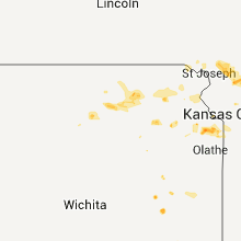
Hail Map for Tuesday, July 12, 2011

Number of Impacted Households on 7/12/2011
0
Impacted by 1" or Larger Hail
0
Impacted by 1.75" or Larger Hail
0
Impacted by 2.5" or Larger Hail
Square Miles of Populated Area Impacted on 7/12/2011
0
Impacted by 1" or Larger Hail
0
Impacted by 1.75" or Larger Hail
0
Impacted by 2.5" or Larger Hail


Cities Most Affected by Hail Storms of 7/12/2011
| Hail Size | Demographics of Zip Codes Affected | ||||||
|---|---|---|---|---|---|---|---|
| City | Count | Average | Largest | Pop Density | House Value | Income | Age |
| Cheyenne, WY | 7 | 1.79 | 2.00 | 60 | $113k | $43.4k | 37.6 |
| Novinger, MO | 1 | 2.00 | 2.00 | 11 | $33k | $30.1k | 44.8 |
| Burns, WY | 1 | 2.00 | 2.00 | 5 | $78k | $40.8k | 41.6 |
| Fe Warren AFB, WY | 1 | 1.75 | 1.75 | 0 | $0k | $0.0k | 21.2 |
| Hillsdale, WY | 1 | 1.75 | 1.75 | 0 | $225k | $42.1k | 38.1 |
| Kansas City, MO | 1 | 1.75 | 1.75 | 42 | $15k | $25.3k | 46.8 |
| Elbert, CO | 1 | 1.75 | 1.75 | 23 | $220k | $76.4k | 45.1 |
| Deer Trail, CO | 1 | 1.75 | 1.75 | 1 | $111k | $37.3k | 42.8 |
Hail and Wind Damage Spotted on 7/12/2011
Filter by Report Type:Hail ReportsWind Reports
States Impacted
Georgia, Kentucky, Tennessee, Oklahoma, Missouri, Alabama, Mississippi, Maine, Arkansas, Illinois, Montana, Kansas, Indiana, Colorado, Louisiana, WyomingGeorgia
| Local Time | Report Details |
|---|---|
| 3:46 PM UTC | Public reported 4 trees down in breme in haralson county GA, 43.7 miles W of Atlanta, GA |
| 7:22 PM UTC | Fayette county 911 relayed reports of 2 downed trees and 4-5 downed powerlines in and around the square in fayettevill in fayette county GA, 20.8 miles S of Atlanta, GA |
| 7:40 PM UTC | Quarter sized hail reported near Atlanta, GA, 4.4 miles NNW of Atlanta, GA, public reports quarter sized hail and intense lightning near howell mill road and interstate 75. |
Kentucky
| Local Time | Report Details |
|---|---|
| 5:25 PM UTC | Two trees down along kentucky highway 7 in taylor county KY, 51.2 miles SSE of Louisville, KY |
| 6:14 PM UTC | Trees and power lines down in the cit in barren county KY, 69 miles S of Louisville, KY |
| 6:30 PM UTC | Trees and power lines dow in barren county KY, 61.5 miles S of Louisville, KY |
| 6:45 PM UTC | Power lines down and a roof off of a barn. lightning strikes house as well. reported by a weht viewer. time approximated from rada in daviess county KY, 43.1 miles ESE of Evansville, IN |
| 7:30 PM UTC | Trees down county wide in hart county KY, 45 miles SSW of Louisville, KY |
| 7:31 PM UTC | Twelve inch diameter tree dow in larue county KY, 33.6 miles SSW of Louisville, KY |
| 9:28 PM UTC | Power lines reported down near taylorsville and logan station rds... webbmont circle... and henry clay and 2nd streets in shelby county KY, 31 miles ENE of Louisville, KY |
| 9:30 PM UTC | Spotter reports young tree broken off about halfway up the tree in shelby county KY, 31 miles ENE of Louisville, KY |
| 10:42 PM UTC | Large limb was blown down along little lick fork off of route 175 in johnson county KY, 63.4 miles E of Irvine, KY |
Tennessee
| Local Time | Report Details |
|---|---|
| 6:00 PM UTC | One tree down on larson springs rd and one down on valley view hw in marion county TN, 15.9 miles NW of Chattanooga, TN |
| 9:00 PM UTC | Roof damage to building on hedgemont ave near robertson st in lincoln county TN, 67.2 miles ENE of Florence, AL |
| 9:29 PM UTC | Roof damage to horse barn on hedgemont ave near robertson st in fayettevill in lincoln county TN, 67.2 miles ENE of Florence, AL |
| 9:30 PM UTC | Trees and powerlines down along amana ave in fayettevill in lincoln county TN, 66.7 miles ENE of Florence, AL |
| 9:40 PM UTC | By the west fayetteville fairgrounds there are trees on in lincoln county TN, 66.7 miles ENE of Florence, AL |
Oklahoma
| Local Time | Report Details |
|---|---|
| 6:30 PM UTC | Damage reported to power lines in the midwest city area in oklahoma county OK, 8.5 miles E of Oklahoma City, OK |
| 7:10 PM UTC | 55 to 60 mph wind gusts measured at the instersection of sw 59th street and south may avenue in oklahoma county OK, 4.9 miles SW of Oklahoma City, OK |
| 7:38 PM UTC | Recorded by okc micronet in oklahoma county OK, 6.3 miles SW of Oklahoma City, OK |
| 7:40 PM UTC | Quarter sized hail reported near Oklahoma City, OK, 6.2 miles SW of Oklahoma City, OK, nickel to quarter sized hail falling north of airport on meridian ave |
| 8:10 PM UTC | The roof to the cowboy book blown off onto a vehicl in payne county OK, 51.6 miles NNE of Oklahoma City, OK |
| 8:12 PM UTC | Measured by kpwa asos in oklahoma county OK, 8.3 miles WNW of Oklahoma City, OK |
| 8:19 PM UTC | Barn roof blown off and car port destroye in osage county OK, 10.6 miles NW of Tulsa, OK |
| 8:24 PM UTC | Storm damage reported in oklahoma county OK, 8.3 miles WNW of Oklahoma City, OK |
| 8:58 PM UTC | Storm damage reported in oklahoma county OK, 8.5 miles SW of Oklahoma City, OK |
| 9:35 PM UTC | Storm damage reported in kingfisher county OK, 36.1 miles NW of Oklahoma City, OK |
| 12:05 AM UTC | Measured by the muskogee aso in muskogee county OK, 46.9 miles SE of Tulsa, OK |
Missouri
| Local Time | Report Details |
|---|---|
| 6:30 PM UTC | Hen Egg sized hail reported near Novinger, MO, 53.9 miles WSW of Kahoka, MO |
| 6:39 PM UTC | Storm damage reported in adair county MO, 47.9 miles WSW of Kahoka, MO |
| 6:39 PM UTC | Several large tree branches were reported down in town. thunderstorm wind gusts were estimated up to 60 mp in adair county MO, 47.9 miles WSW of Kahoka, MO |
| 7:05 PM UTC | 8 inch tree knocked over into the westbound lane of hwy 156 one mile east of la plata. time estimated by rada in macon county MO, 48 miles SW of Kahoka, MO |
| 7:22 PM UTC | Flagpole blown down and 2 vechicles windows blown out at the kirksville airpor in adair county MO, 48.6 miles WSW of Kahoka, MO |
| 7:22 PM UTC | Flagpole blown down and 2 vehicles windows blown out at the kirksville airpor in adair county MO, 48.6 miles WSW of Kahoka, MO |
| 7:27 PM UTC | Storm damage reported in knox county MO, 38.4 miles SW of Kahoka, MO |
| 7:33 PM UTC | Ping Pong Ball sized hail reported near Plevna, MO, 37 miles SW of Kahoka, MO |
| 8:43 PM UTC | Storm damage reported in marion county MO, 44.1 miles SSE of Kahoka, MO |
| 8:44 PM UTC | Highway billboard knocked down onto highway 7 in marion county MO, 52.2 miles SSE of Kahoka, MO |
| 8:45 PM UTC | Storm damage reported in marion county MO, 50.6 miles SSE of Kahoka, MO |
| 8:45 PM UTC | Multiple tree limbs down...8 inches in diameter in marion county MO, 50.3 miles SSE of Kahoka, MO |
| 8:47 PM UTC | Storm damage reported in marion county MO, 52.2 miles SSE of Kahoka, MO |
| 8:47 PM UTC | Numerous reports of trees and power lines down throughout town. also several trees on cars and homes. in addition... several fires caused by power lines down and possib in marion county MO, 52.2 miles SSE of Kahoka, MO |
| 8:57 PM UTC | Siding ripped off several homes in addition to numerous tree limbs down... some over a foot in diamete in marion county MO, 52.2 miles SSE of Kahoka, MO |
| 9:22 PM UTC | One foot diameter tree blown over in addition to tree limbs falling over power line in pike county MO, 66.5 miles ENE of Columbia, MO |
| 9:47 PM UTC | Numerous wires down causing power outage in pike county MO, 72.7 miles NW of Saint Louis, MO |
| 11:08 PM UTC | Quarter sized hail reported near Amity, MO, 54.6 miles N of Kansas City, MO |
| 11:30 PM UTC | Quarter sized hail reported near Maysville, MO, 54.2 miles NNE of Kansas City, MO |
| 11:47 PM UTC | Five to seven inch tree limbs downed in caldwell county MO, 48.1 miles NNE of Kansas City, MO |
| 1:15 AM UTC | Strong winds snapped off large tree...flipped over play structure...and removed siding from house. numerous limbs down across area. time estimate in reynolds county MO, 34.8 miles ESE of Salem, MO |
| 1:45 AM UTC | A carport was flipped upside down and large limbs blown dow in miller county MO, 48.1 miles SSW of Columbia, MO |
| 2:20 AM UTC | Emeregency manager reports a tree blown down by winds from decaying thunderstorm near truman road and fields roa in jackson county MO, 22.6 miles E of Kansas City, MO |
| 2:30 AM UTC | Quarter sized hail reported near Lee's Summit, MO, 16.4 miles SE of Kansas City, MO, 470 and woods chapel rd |
| 2:43 AM UTC | Golf Ball sized hail reported near Kansas City, MO, 2.1 miles ENE of Kansas City, MO, near 4300 block of independence ave. amatuer radio operater reported golfball sized hail. |
| 2:43 AM UTC | Amateur radio operator near the 4300 block of independence ave reported several 65 mph wind gusts over the last 5 to 10 minutes. also had up to golfball sized hail in jackson county MO, 2.1 miles ENE of Kansas City, MO |
| 3:15 AM UTC | A national weather service storm survey revealed that a microburst with winds estimated around 90 mph snapped several trees that were 2 to 3 feet in diameter. one tree in miller county MO, 42.9 miles S of Columbia, MO |
| 4:22 AM UTC | One boat dock was destroyed and minor damage to boats. a few trees blown down. winds estimated from 60 to 70 mp in morgan county MO, 52.3 miles SSW of Columbia, MO |
| 4:22 AM UTC | Boat dock damaged. wind gust also flipped several boats over and set others adrif in morgan county MO, 53.5 miles SSW of Columbia, MO |
| 4:22 AM UTC | One boat dock was destroyed and minor damage to boats. a few trees blown down. winds estimated from 60 to 70 mp in morgan county MO, 51.7 miles SSW of Columbia, MO |
| 4:25 AM UTC | Barn damaged and trees downed near intersection of highways aa and h in jasper county MO, 62.4 miles W of Springfield, MO |
| 4:47 AM UTC | A national weather service storm survey revealed that a microburst with winds estimated between 90 and 100 mph partially peeled a roof off of a garage. these winds also in jasper county MO, 63 miles W of Springfield, MO |
| 7:21 AM UTC | Severe thunderstorm wind gusts snapped a large tree three miles north of grovesprin in wright county MO, 40.8 miles ENE of Springfield, MO |
Alabama
| Local Time | Report Details |
|---|---|
| 7:05 PM UTC | A power pole was knocked down. time estimated by radar of gust fron in dekalb county AL, 45 miles SW of Chattanooga, TN |
| 8:11 PM UTC | Power outage in southeast huntsville caused by a tree on the lines on blevins gap road...three poles damaged on four mile post road...and a tree on lines on big cove ro in madison county AL, 63.8 miles E of Florence, AL |
| 9:35 PM UTC | Large tree down at pankey and nixon chapel rd in marshall county AL, 55.4 miles NNE of Birmingham, AL |
| 9:45 PM UTC | Quarter sized hail reported near Athens, AL, 45.3 miles E of Florence, AL, in east limestone on capshaw rd |
| 9:45 PM UTC | Quarter sized hail reported near Huntsville, AL, 51 miles E of Florence, AL, in east limestone on capshaw rd |
| 9:50 PM UTC | 4inch diameter broken pear tree limbs at jarrod blvd and kim rd in limestone county AL, 47.6 miles E of Florence, AL |
| 9:50 PM UTC | Small tree limbs down at east limestone rd and capshaw rd in limestone county AL, 48.1 miles E of Florence, AL |
| 9:50 PM UTC | Two trees snapped 7 miles east of athens near east limestone rd on south side of hwy 7 in limestone county AL, 47.5 miles E of Florence, AL |
| 9:55 PM UTC | Quarter sized hail reported near Harvest, AL, 48.1 miles E of Florence, AL, quarter sized hail at casey pl and shelby st |
Mississippi
| Local Time | Report Details |
|---|---|
| 7:22 PM UTC | Power line down along cr 1 in smith county MS, 53 miles SE of Jackson, MS |
| 8:18 PM UTC | A couple trees down off sanford r in jones county MS, 75.1 miles SE of Jackson, MS |
| 8:22 PM UTC | Some trees were reported down east of utic in hinds county MS, 25.6 miles WSW of Jackson, MS |
| 8:38 PM UTC | Some trees were down around the city of mcnai in jefferson county MS, 67.9 miles SW of Jackson, MS |
| 9:13 PM UTC | Downed power lines in clinton in hinds county MS, 9.2 miles WNW of Jackson, MS |
| 9:13 PM UTC | Powerlines down due to downed trees around sumral in lamar county MS, 72.9 miles SSE of Jackson, MS |
| 9:27 PM UTC | Numerous trees and power lines down in flora. dime size hail also reporte in madison county MS, 18.9 miles NNW of Jackson, MS |
| 9:27 PM UTC | Storage building blown onto hwy 49. awnings blown off buildings. large trees down on old hwy 49. multiple power outage in madison county MS, 18.9 miles NNW of Jackson, MS |
| 9:35 PM UTC | Powerline down due to downed trees near columbi in marion county MS, 74 miles SSE of Jackson, MS |
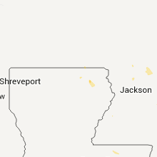
| 1:20 AM UTC | Power lines down in the city of columbus in lowndes county MS, 24 miles E of Starkville, MS |
Maine
| Local Time | Report Details |
|---|---|
| 8:00 PM UTC | Large tree took down power line on main stee in aroostook county ME, 33.9 miles NNW of Caribou, ME |
| 8:00 PM UTC | Large tree took down power line on main stree in aroostook county ME, 33.9 miles NNW of Caribou, ME |
| 8:10 PM UTC | Numerous trees blown down across 161. portions of route 161 are blocked due to the downed tree in aroostook county ME, 53.9 miles WNW of Caribou, ME |
| 8:15 PM UTC | Numerous trees down on power lines along route 161. power outage in aroostook county ME, 50.7 miles WNW of Caribou, ME |
| 8:21 PM UTC | Trees down with power outages. time is estimate in aroostook county ME, 47.3 miles WNW of Caribou, ME |
| 8:45 PM UTC | Numerous power outages in town. still without powe in aroostook county ME, 30.1 miles WNW of Caribou, ME |
| 9:00 PM UTC | Trees down along route 11. time is estimate in aroostook county ME, 30.1 miles WNW of Caribou, ME |
| 9:15 PM UTC | Large tree down in tow in aroostook county ME, 23.3 miles WSW of Caribou, ME |
| 9:25 PM UTC | Trees down along the washburn route 164 between washburn and crousevill in aroostook county ME, 8.5 miles SW of Caribou, ME |
| 9:30 PM UTC | Large tree down on route 1 in aroostook county ME, 27.5 miles WNW of Caribou, ME |
| 9:30 PM UTC | A large tree down along route in aroostook county ME, 11 miles S of Caribou, ME |
| 9:30 PM UTC | All the flag poles down and bent at the family christian cente in aroostook county ME, 11 miles S of Caribou, ME |
| 9:30 PM UTC | Trees down along parsons roa in aroostook county ME, 12.5 miles S of Caribou, ME |
| 9:35 PM UTC | Large tree down on the spragueville roa in aroostook county ME, 12.4 miles S of Caribou, ME |
| 9:38 PM UTC | Large tree took down a power line on the fort roa in aroostook county ME, 12.4 miles S of Caribou, ME |
| 9:38 PM UTC | Large tree down on the washburn road in aroostook county ME, 9.7 miles SSW of Caribou, ME |
Arkansas
| Local Time | Report Details |
|---|---|
| 8:22 PM UTC | Several trees and powerlines down near hambur in ashley county AR, 32.2 miles N of Bastrop, LA |
| 9:55 PM UTC | Trees and power lines reported down along co rd 2 in calhoun county AR, 57.5 miles NNW of Bastrop, LA |
| 5:30 AM UTC | Trees downed on pine street and union road in harrison...with several vehicles damage in boone county AR, 67.5 miles S of Springfield, MO |
Illinois
| Local Time | Report Details |
|---|---|
| 8:31 PM UTC | Ping Pong Ball sized hail reported near Quincy, IL, 42.6 miles SE of Kahoka, MO, relayed by spotters at quincy regional airport. |
| 8:45 PM UTC | Quarter sized hail reported near Liberty, IL, 49.3 miles SE of Kahoka, MO |
| 8:47 PM UTC | Powerlines dow in sangamon county IL, 70.7 miles S of Peoria, IL |
| 8:54 PM UTC | Several reports of trees and power lines dow in adams county IL, 48.6 miles SSE of Kahoka, MO |
| 8:54 PM UTC | Shingles blown off of a residenc in adams county IL, 48 miles SSE of Kahoka, MO |
| 9:12 PM UTC | Multiple tree limbs and power lines down. also multiple roofs ripped off residence in pike county IL, 61.4 miles SE of Kahoka, MO |
| 9:12 PM UTC | Roof ripped off a librar in pike county IL, 61.4 miles SE of Kahoka, MO |
| 9:20 PM UTC | Multiple tree limbs down 3 to 4 inches in diameter. time estimated from radar in jersey county IL, 34.7 miles NNW of Saint Louis, MO |
| 9:20 PM UTC | 2 pieces of plywood blown off of a small shed in jersey county IL, 30.8 miles NNW of Saint Louis, MO |
| 10:00 PM UTC | Multiple trees and limbs down up to 6 inches in diameter...street lights also damaged in jersey county IL, 34.7 miles NNW of Saint Louis, MO |
| 10:11 PM UTC | Large trees uprooted and snapped off. power lines also damage in greene county IL, 49.1 miles N of Saint Louis, MO |
| 10:16 PM UTC | Numerous small trees down with estimated 60 mph wind in greene county IL, 49.1 miles N of Saint Louis, MO |
| 10:40 PM UTC | Power lines down in lawrence county IL, 53.7 miles NNW of Evansville, IN |
| 11:05 PM UTC | Tree limbs and power lines down in lawrence county IL, 52.4 miles N of Evansville, IN |
| 12:10 AM UTC | Tree limbs and power lines down in richland county IL, 54.1 miles SSE of Mattoon, IL |
| 3:00 AM UTC | Trees down over rt 3 near olive branc in alexander county IL, 14.1 miles SE of Cape Girardeau, MO |
Montana
| Local Time | Report Details |
|---|---|
| 8:45 PM UTC | Quarter sized hail reported near Garrison, MT, 56.9 miles ESE of Missoula, MT, quarter size hail covered the ground. |
| 12:10 AM UTC | Wind gust measured at 38 mph knocked a few 3 inch diameter branches off trees. spotter thinks that winds may have been a bit stronger than that. he also reported brief in chouteau county MT, 37.5 miles NE of Great Falls, MT |
Kansas
| Local Time | Report Details |
|---|---|
| 9:00 PM UTC | Winds estimated at 60 mph with doors to home blown in and steel patio table overturne in dickinson county KS, 33.8 miles W of Manhattan, KS |
| 9:18 PM UTC | Public reports to kake that there were utility poles and 6 to 12 inch diameter trees snapped. time is radar estimate in sumner county KS, 23.4 miles S of Wichita, KS |
| 9:30 PM UTC | *** 1 inj *** delayed report from emergency manager of a car accident where the injured party reports the wind blowing her off the road. time is radar estimate in butler county KS, 16.1 miles SE of Wichita, KS |
| 9:40 PM UTC | Emergency manager reports multiple trees down of 6 to 12 inches in diameter and covering roadway in montgomery county KS, 45.2 miles SSW of Chanute, KS |
| 9:55 PM UTC | Estimated 58mph wind in sedgwick county KS, 3.6 miles SE of Wichita, KS |
| 10:25 PM UTC | The top of a wooden barn was destroyed. 1 foot diameter trees were split off of the main tree trunk. outer sections of windows on house were ripped off. tree branches w in riley county KS, 26.7 miles NW of Manhattan, KS |
| 10:45 PM UTC | Quarter sized hail reported near Holton, KS, 49.9 miles ENE of Manhattan, KS, sliding patio door window broken out. window west facing. |
| 10:55 PM UTC | 2 inch diamater limbs reported dow in pottawatomie county KS, 18.5 miles NNW of Manhattan, KS |
| 11:30 PM UTC | 5 power poles down on west side of u.s. highway 7 in coffey county KS, 48 miles NNW of Chanute, KS |
| 11:32 PM UTC | 3 large diameter power poles reported down west of wheato in pottawatomie county KS, 24.7 miles NNE of Manhattan, KS |
| 12:45 AM UTC | 2 to 4 inch diameter tree limbs down. storage shed had roof and two sides damage in shawnee county KS, 42 miles E of Manhattan, KS |
| 2:00 AM UTC | Quarter sized hail reported near Bonner Springs, KS, 19.2 miles W of Kansas City, MO |
| 9:01 PM CDT | Quarter sized hail reported near Bonner Springs, KS, 20.6 miles W of Kansas City, MO, quarter size hail |
| 2:24 AM UTC | Storm damage reported in johnson county KS, 14.9 miles SW of Kansas City, MO |
Indiana
| Local Time | Report Details |
|---|---|
| 10:01 PM UTC | Trees and power lines down in gibson county IN, 25.1 miles NNE of Evansville, IN |
Colorado
| Local Time | Report Details |
|---|---|
| 10:23 PM UTC | Quarter sized hail reported near Elizabeth, CO, 38.6 miles SE of Denver, CO |
| 10:32 PM UTC | Half Dollar sized hail reported near Elizabeth, CO, 38.6 miles SE of Denver, CO |
| 10:41 PM UTC | Quarter sized hail reported near Kiowa, CO, 37.4 miles SE of Denver, CO |
| 12:52 AM UTC | Golf Ball sized hail reported near Deer Trail, CO, 46.3 miles ESE of Denver, CO |
| 2:42 AM UTC | Golf Ball sized hail reported near Elbert, CO, 43.6 miles SE of Denver, CO |
| 3:05 AM UTC | Quarter sized hail reported near Elbert, CO, 47.2 miles SE of Denver, CO |
| 3:54 AM UTC | Storm damage reported in denver county CO, 1.8 miles ESE of Denver, CO |
| 3:54 AM UTC | Large tree blown down at 114th and chambers in adams county CO, 6.2 miles NE of Denver, CO |
| 3:55 AM UTC | Denver international airport in denver county CO, 1.8 miles ESE of Denver, CO |
Louisiana
| Local Time | Report Details |
|---|---|
| 10:50 PM UTC | Two trees and and some power lines dow in morehouse county LA, 0.6 miles SSE of Bastrop, LA |
Wyoming
| Local Time | Report Details |
|---|---|
| 11:08 PM UTC | Hen Egg sized hail reported near Cheyenne, WY, 41.3 miles ESE of Laramie, WY, many vehicles dented. one vehicle lost its windshield. |
| 11:15 PM UTC | Half Dollar sized hail reported near Cheyenne, WY, 42.3 miles ESE of Laramie, WY |
| 11:15 PM UTC | Ping Pong Ball sized hail reported near Cheyenne, WY, 41.1 miles ESE of Laramie, WY, many vehicles dented. a roof was damaged. |
| 11:25 PM UTC | Quarter sized hail reported near Cheyenne, WY, 42.1 miles ESE of Laramie, WY |
| 11:28 PM UTC | Quarter sized hail reported near Fe Warren Afb, WY, 40.1 miles ESE of Laramie, WY |
| 11:30 PM UTC | Quarter sized hail reported near Cheyenne, WY, 43.1 miles ESE of Laramie, WY |
| 11:30 PM UTC | Half Dollar sized hail reported near Cheyenne, WY, 43 miles ESE of Laramie, WY |
| 11:30 PM UTC | Half Dollar sized hail reported near Cheyenne, WY, 44.5 miles E of Laramie, WY |
| 11:31 PM UTC | Golf Ball sized hail reported near Cheyenne, WY, 43.1 miles ESE of Laramie, WY, hail broke through car windshield downtown with other cars receiving large cracks in the windshield |
| 11:33 PM UTC | Golf Ball sized hail reported near Cheyenne, WY, 43.1 miles ESE of Laramie, WY, quarter to golfball hail |
| 11:35 PM UTC | Quarter sized hail reported near Cheyenne, WY, 43.1 miles ESE of Laramie, WY |
| 11:39 PM UTC | Quarter sized hail reported near Cheyenne, WY, 44.5 miles E of Laramie, WY |
| 11:39 PM UTC | Golf Ball sized hail reported near Cheyenne, WY, 43.1 miles ESE of Laramie, WY |
| 11:39 PM UTC | Ping Pong Ball sized hail reported near Cheyenne, WY, 43.1 miles ESE of Laramie, WY |
| 11:40 PM UTC | Quarter sized hail reported near Cheyenne, WY, 41.3 miles ESE of Laramie, WY |
| 11:40 PM UTC | Golf Ball sized hail reported near Cheyenne, WY, 43.3 miles ESE of Laramie, WY, 1.21 inches of rainfall. hail lasted 25 minutes. via espotter |
| 11:40 PM UTC | Golf Ball sized hail reported near Cheyenne, WY, 41.9 miles ESE of Laramie, WY, greenhouse windows were broken. |
| 11:45 PM UTC | Golf Ball sized hail reported near Cheyenne, WY, 42.8 miles ESE of Laramie, WY |
| 11:45 PM UTC | Golf Ball sized hail reported near Fe Warren Afb, WY, 40.1 miles ESE of Laramie, WY, windshield broken on car at fe warren airforce base |
| 11:48 PM UTC | Quarter sized hail reported near Cheyenne, WY, 42.5 miles E of Laramie, WY, raining heavy as well. |
| 11:50 PM UTC | Quarter sized hail reported near Cheyenne, WY, 45.9 miles E of Laramie, WY |
| 12:30 AM UTC | Ping Pong Ball sized hail reported near Carpenter, WY, 63.5 miles SW of Scottsbluff, NE |
| 12:34 AM UTC | Quarter sized hail reported near Cheyenne, WY, 55.2 miles E of Laramie, WY, just east of mile marker 375 on interstate 80 |
| 12:36 AM UTC | Hen Egg sized hail reported near Burns, WY, 54.8 miles ESE of Laramie, WY |
| 12:43 AM UTC | Golf Ball sized hail reported near Hillsdale, WY, 56.1 miles E of Laramie, WY |
| 12:56 AM UTC | Half Dollar sized hail reported near Carpenter, WY, 57.3 miles ESE of Laramie, WY, 2 inches of water over the road. significant flooding in washes and ditches. via spotternetwork |
| 1:19 AM UTC | Quarter sized hail reported near Cheyenne, WY, 43.4 miles E of Laramie, WY |
| 1:59 AM UTC | Quarter sized hail reported near , , 68.6 miles ESE of Laramie, WY |
Connect with Interactive Hail Maps