

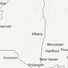
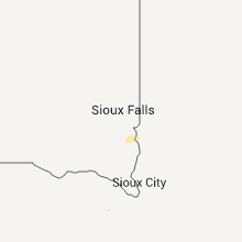
Hail Map for Wednesday, July 13, 2011

Number of Impacted Households on 7/13/2011
0
Impacted by 1" or Larger Hail
0
Impacted by 1.75" or Larger Hail
0
Impacted by 2.5" or Larger Hail
Square Miles of Populated Area Impacted on 7/13/2011
0
Impacted by 1" or Larger Hail
0
Impacted by 1.75" or Larger Hail
0
Impacted by 2.5" or Larger Hail


Cities Most Affected by Hail Storms of 7/13/2011
| Hail Size | Demographics of Zip Codes Affected | ||||||
|---|---|---|---|---|---|---|---|
| City | Count | Average | Largest | Pop Density | House Value | Income | Age |
| Fort Collins, CO | 2 | 1.75 | 1.75 | 2017 | $191k | $53.4k | 35.5 |
| Colby, KS | 2 | 1.75 | 1.75 | 13 | $79k | $37.3k | 35.7 |
| Loveland, CO | 2 | 1.75 | 1.75 | 422 | $167k | $52.0k | 40.6 |
| Conifer, CO | 1 | 2.00 | 2.00 | 94 | $230k | $76.5k | 47.2 |
| Lewistown, MT | 1 | 1.75 | 1.75 | 8 | $74k | $30.8k | 47.6 |
| Wilsonville, NE | 1 | 1.75 | 1.75 | 1 | $24k | $34.7k | 52.8 |
| Box Elder, MT | 1 | 1.75 | 1.75 | 6 | $36k | $23.6k | 22.9 |
| Colorado Springs, CO | 1 | 1.75 | 1.75 | 3115 | $182k | $68.7k | 36.0 |
| Brandon, MN | 1 | 1.75 | 1.75 | 17 | $84k | $37.6k | 45.5 |
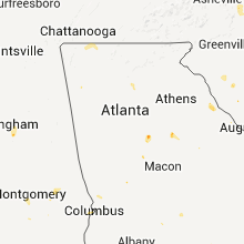
Hail and Wind Damage Spotted on 7/13/2011
Filter by Report Type:Hail ReportsWind Reports
States Impacted
North Carolina, Virginia, Tennessee, South Carolina, Oklahoma, Georgia, Mississippi, Arkansas, Montana, Wyoming, Alabama, Maryland, Colorado, New York, Kansas, Vermont, Louisiana, Massachusetts, New Jersey, Nebraska, Texas, New Mexico, Utah, MinnesotaNorth Carolina
| Local Time | Report Details |
|---|---|
| 5:55 PM UTC | Tree blow down on a power line on reedy creek in wilkes county NC, 56.6 miles ESE of Bristol, TN |
| 5:55 PM UTC | The wilkes county sheriffs office reported three trees down on lewis fork baptist church road near hwy 42 in wilkes county NC, 56.9 miles ESE of Bristol, TN |
| 5:55 PM UTC | Quarter sized hail reported near Purlear, NC, 56.6 miles ESE of Bristol, TN, hail started as pea size at 125 pm and grew to the size of a quarter around 155 pm. report from wxii-tv. |
| 6:30 PM UTC | One tree and several tree limbs downed in the ronda are in wilkes county NC, 69 miles N of Charlotte, NC |
| 6:36 PM UTC | Tree down on church road at hwy 6 in alexander county NC, 53.8 miles NNW of Charlotte, NC |
| 6:36 PM UTC | Tree down on black oak ridge road between taylorsville and sugar loaf. time estimated from rada in alexander county NC, 53.7 miles NNW of Charlotte, NC |
| 6:50 PM UTC | Quarter sized hail reported near Ferguson, NC, 56.1 miles SE of Bristol, TN |
| 6:57 PM UTC | The yadkin county sheriffs office reported a tree blown down near the campus of the surry community college on hwy 60 in yadkin county NC, 64.6 miles N of Charlotte, NC |
| 7:10 PM UTC | Several trees and large limbs down in yadkin county NC, 69.9 miles N of Charlotte, NC |
| 7:25 PM UTC | Power lines down just east of statesville on twin oaks roa in iredell county NC, 39.2 miles N of Charlotte, NC |
| 7:36 PM UTC | Three trees down on painters gap roa in rutherford county NC, 57 miles NE of Greenville, SC |
| 7:36 PM UTC | Three trees down on painters gap roa in rutherford county NC, 57.1 miles NE of Greenville, SC |
| 7:50 PM UTC | Multiple powerlines dow in davie county NC, 49.3 miles NNE of Charlotte, NC |
| 7:54 PM UTC | Tree down near shopping center in cooleeme in davie county NC, 43.4 miles NNE of Charlotte, NC |
| 8:03 PM UTC | Trees and powerlines down on perth roa in iredell county NC, 30.3 miles N of Charlotte, NC |
| 8:05 PM UTC | One tree down at swanns station road and frank wicker r in lee county NC, 38.8 miles SW of Raleigh, NC |
| 8:06 PM UTC | One tree down in 3100 block of cameron driv in lee county NC, 38.8 miles SW of Raleigh, NC |
| 8:20 PM UTC | Tree down at gates lane and gastonia hw in lincoln county NC, 26.8 miles NW of Charlotte, NC |
| 8:20 PM UTC | Tree on power line - wires down on huckleberry driv in lincoln county NC, 28.7 miles NW of Charlotte, NC |
| 8:24 PM UTC | Tree down on north post road and new prospect roa in cleveland county NC, 38.1 miles W of Charlotte, NC |
| 8:24 PM UTC | Tree down at mcbriar springs road and east zion church roa in cleveland county NC, 38.9 miles WNW of Charlotte, NC |
| 8:25 PM UTC | One tree down near intersection of us 1 and materials drive in franklin county NC, 21.6 miles NNE of Raleigh, NC |
| 8:28 PM UTC | Large tree limb down on us 1 between franklinton and youngsville in franklin county NC, 22.3 miles NNE of Raleigh, NC |
| 8:43 PM UTC | One tree down on moores pond rd in franklin county NC, 18.3 miles NE of Raleigh, NC |
| 8:44 PM UTC | One tree down in the 1000 block of moores pond road in franklin county NC, 18.8 miles NE of Raleigh, NC |
| 8:58 PM UTC | Multiple trees down on shopton roa in mecklenburg county NC, 6.1 miles SW of Charlotte, NC |
| 8:59 PM UTC | One tree down on pearces rd in franklin county NC, 21.4 miles ENE of Raleigh, NC |
| 9:04 PM UTC | Trees down throughout the county in stanly county NC, 28.7 miles E of Charlotte, NC |
| 9:04 PM UTC | One tree down at williams-white r in franklin county NC, 21.3 miles ENE of Raleigh, NC |
| 9:07 PM UTC | Tree down near the intersection of w 4th street and poplar s in mecklenburg county NC, 1.6 miles SSE of Charlotte, NC |
| 9:10 PM UTC | Multiple reports of power lines down in charlotte area...bradford dr...fairgrounds st...westerly hills d in mecklenburg county NC, 1.6 miles SSE of Charlotte, NC |
| 9:10 PM UTC | Temporary construction wall damaged and shifted into rum bar and grill on concourse d at charlotte-douglas intl airpor in mecklenburg county NC, 1.6 miles SSE of Charlotte, NC |
| 9:11 PM UTC | Tree down on house in charlotte. no injurie in mecklenburg county NC, 1.6 miles SSE of Charlotte, NC |
| 9:14 PM UTC | Tree down on a powerline in vass in moore county NC, 51 miles SW of Raleigh, NC |
| 9:19 PM UTC | Tree down on sw broad st in moore county NC, 59.8 miles SW of Raleigh, NC |
| 9:19 PM UTC | Tree down on sw broad st in moore county NC, 60.7 miles SW of Raleigh, NC |
| 9:25 PM UTC | 6 trees down near camp mackall in scotland county NC, 71.4 miles SW of Raleigh, NC |
| 5:30 PM EDT | One tree down on highway 742n near the county line in anson county NC, 32.6 miles E of Charlotte, NC |
| 9:33 PM UTC | Several 3-4 inch limbs down at the intersection of lawyers road and stevens mill roa in union county NC, 15.7 miles ESE of Charlotte, NC |
| 9:34 PM UTC | Tree down on roseland road off of us 1 in moore county NC, 63.4 miles SW of Raleigh, NC |
| 9:48 PM UTC | One tree down off highway 109n in anson county NC, 48.4 miles ESE of Charlotte, NC |
| 10:19 PM UTC | Trees down on rennert r in robeson county NC, 71.6 miles SSW of Raleigh, NC |
| 10:35 PM UTC | Tree down across power lines at the 7100 block of white plains church rd in bladen county NC, 46.3 miles NW of Wilmington, NC |
| 10:44 PM UTC | Part of a roof torn off a house on frank norris road. time estimated based off rada in columbus county NC, 53.6 miles W of Wilmington, NC |
| 10:48 PM UTC | A few trees down on highway 701 between white lake and elizabethtown in bladen county NC, 43.1 miles NW of Wilmington, NC |
| 10:52 PM UTC | Limbs down on clarendon chadbourn rd and dime size hail in columbus county NC, 50.9 miles W of Wilmington, NC |
| 11:08 PM UTC | Several trees down just south of highway 211 in bladen county NC, 47.7 miles WNW of Wilmington, NC |
| 11:08 PM UTC | Half Dollar sized hail reported near Bladenboro, NC, 47.7 miles WNW of Wilmington, NC, hail up to the size of half dollars. |
| 11:10 PM UTC | Large tree down on power line. also dime to nickle size hai in bladen county NC, 45.8 miles WNW of Wilmington, NC |
| 11:10 PM UTC | Large trees down just off page roa in columbus county NC, 46.9 miles WNW of Wilmington, NC |
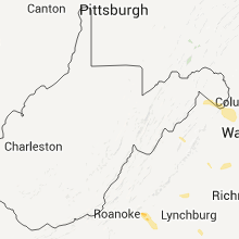
Virginia
| Local Time | Report Details |
|---|---|
| 5:56 PM UTC | Tree down in campbell county VA, 36.4 miles E of Roanoke, VA |
| 6:26 PM UTC | Tree down at intersection of herndon parkway and crestview driv in fairfax county VA, 47.6 miles WSW of Baltimore, MD |
| 6:32 PM UTC | Trees down at 1228 stringtown r in clarke county VA, 73.8 miles W of Baltimore, MD |
| 6:32 PM UTC | Two trees down at 1497 trapp hill r in clarke county VA, 74.5 miles W of Baltimore, MD |
| 6:35 PM UTC | Tree down in campbell county VA, 48.2 miles E of Roanoke, VA |
| 6:36 PM UTC | Trees down at 234 treadwell s in clarke county VA, 74.1 miles W of Baltimore, MD |
| 6:41 PM UTC | Trees down at 1800 chilly hollow r in clarke county VA, 71.7 miles W of Baltimore, MD |
| 6:55 PM UTC | 2 to 3 inch diameter limbs dow in fairfax county VA, 47.1 miles SW of Baltimore, MD |
| 6:59 PM UTC | Trees and wires down in loudoun county VA, 62.7 miles WSW of Baltimore, MD |
| 7:25 PM UTC | Large tree snapped along featherbed lane in the manassas battlefield in prince william county VA, 59.7 miles WSW of Baltimore, MD |
| 7:32 PM UTC | Large tree blocking w od trail in fairfax county VA, 47.6 miles WSW of Baltimore, MD |
| 7:32 PM UTC | Tree down near the intersection of route 123 and horseshoe rd. tree is about 1 ft in diamete in fairfax county VA, 42.9 miles SW of Baltimore, MD |
| 7:49 PM UTC | Many trees down along shuler l in page county VA, 71.9 miles ESE of Elkins, WV |
| 7:53 PM UTC | Numerous trees down on dovel hollow roa in page county VA, 73.6 miles ESE of Elkins, WV |
| 7:53 PM UTC | Numerous trees down on honeyville roa in page county VA, 73.8 miles ESE of Elkins, WV |
| 7:53 PM UTC | Numerous trees dow in page county VA, 73.5 miles ESE of Elkins, WV |
| 7:53 PM UTC | Trees down along dovel hollow r in page county VA, 74.5 miles ESE of Elkins, WV |
| 8:32 PM UTC | Tree down near the intersection of route 123 and horseshoe rd. tree is about 1 ft in diamete in fairfax county VA, 42.9 miles SW of Baltimore, MD |
| 8:51 PM UTC | Tree over roa in orange county VA, 59.5 miles NNW of Richmond, VA |
| 8:53 PM UTC | Trees down along dovel hollow r in page county VA, 74.5 miles ESE of Elkins, WV |
| 8:59 PM UTC | Tree down over road in orange county VA, 57 miles NNW of Richmond, VA |
| 8:59 PM UTC | Tree down into hom in orange county VA, 57.7 miles NNW of Richmond, VA |
| 9:02 PM UTC | Numerous trees down as well as several power poles down in orange county VA, 56.3 miles NNW of Richmond, VA |
| 9:05 PM UTC | Large limbs snapped in orange county VA, 55.3 miles N of Richmond, VA |
| 9:08 PM UTC | Tree down over roa in orange county VA, 54.2 miles NNW of Richmond, VA |
| 9:17 PM UTC | Tree down at courthouse road and smith station roa in spotsylvania county VA, 50.3 miles N of Richmond, VA |
| 9:25 PM UTC | Tree down at courthouse road and lewiston roa in spotsylvania county VA, 42.3 miles N of Richmond, VA |
| 10:50 PM UTC | The buckingham county sheriffs office reported numerous large trees blown down along route 20 at midway marke in buckingham county VA, 48.7 miles WNW of Richmond, VA |
| 12:45 AM UTC | The campbell county sheriffs office reported several tree limbs and a power line blown down in the eastbrook mobile home par in campbell county VA, 46.2 miles E of Roanoke, VA |
| 7:53 AM UTC | Numerous trees dow in page county VA, 73.5 miles ESE of Elkins, WV |
Tennessee
| Local Time | Report Details |
|---|---|
| 6:05 PM UTC | Power lines down at 6900 lee hwy. report by dispatc in hamilton county TN, 10.3 miles E of Chattanooga, TN |
| 6:05 PM UTC | Tree down on power lines at 1500 jenkins road. rpt by dispatch in hamilton county TN, 8.8 miles ESE of Chattanooga, TN |
| 6:13 PM UTC | Tree down reported by dispatch at 1124 bancroft roa in bradley county TN, 22.9 miles ENE of Chattanooga, TN |
| 6:13 PM UTC | Tree down reported by dispatch in bradley county TN, 22.9 miles ENE of Chattanooga, TN |
| 6:15 PM UTC | Tree down reported by dispatch at pleasant grove rd and withrow roa in bradley county TN, 26.5 miles ENE of Chattanooga, TN |
South Carolina
| Local Time | Report Details |
|---|---|
| 6:17 PM UTC | Highway patrol reported trees down on kyzer road near platt springs roa in lexington county SC, 50.7 miles NE of Augusta, GA |
| 6:43 PM UTC | Highway patrol reported trees down near batesbur in lexington county SC, 40.1 miles NE of Augusta, GA |
| 6:44 PM UTC | Highway patrol reported trees down at old golf course road and hwy 17 in saluda county SC, 40.2 miles NE of Augusta, GA |
| 6:50 PM UTC | Highway patrol reported trees down south of monetta in aiken count in aiken county SC, 29.6 miles NE of Augusta, GA |
| 7:15 PM UTC | Sheriff dispatch reported several larege limbs down on maybinton road and gilliam spring roa in newberry county SC, 67.1 miles SSW of Charlotte, NC |
| 7:20 PM UTC | Highway patrol reported trees down near winnsboro along hwy 20 in fairfield county SC, 59.8 miles SSW of Charlotte, NC |
| 7:46 PM UTC | Aiken awos reported a wind gust of 51 knots or 59 mp in aiken county SC, 20.2 miles NE of Augusta, GA |
| 7:46 PM UTC | Sheriff dispatch reported trees down at greenwood hwy atnd larkin rice roa in saluda county SC, 39.1 miles N of Augusta, GA |
| 8:00 PM UTC | Highway patrol reported trees down in chappell in newberry county SC, 48.7 miles N of Augusta, GA |
| 8:00 PM UTC | Tree down at hwy 321 and columbia roa in chester county SC, 46.5 miles SSW of Charlotte, NC |
| 8:00 PM UTC | Tree down on cornwell road just west of cornwel in chester county SC, 47 miles SSW of Charlotte, NC |
| 8:18 PM UTC | Trees down at the intersection of north center rd and patrick hwy. two mobile homes damage in darlington county SC, 67.9 miles SE of Charlotte, NC |
| 8:22 PM UTC | Large limbs down on east home av in darlington county SC, 72.9 miles SE of Charlotte, NC |
| 8:22 PM UTC | Tree blocking the road on lake view blv in darlington county SC, 72.9 miles SE of Charlotte, NC |
| 8:28 PM UTC | Tree down on new market r in darlington county SC, 72.9 miles SE of Charlotte, NC |
| 8:30 PM UTC | Two trees down. one near the intersection of hw-9 and hw-99 and the other on richburg road near beaver dam roa in chester county SC, 37.8 miles SSW of Charlotte, NC |
| 8:40 PM UTC | Sc highway patrol reported trees down at lucknow road and dee lee way in lee county SC, 69.4 miles SSE of Charlotte, NC |
| 8:51 PM UTC | Tree down blocked one lane of traffic on sims ave near the old sims school. time estimated from rada in union county SC, 54.5 miles SW of Charlotte, NC |
| 8:51 PM UTC | Tree down...blocked one lane of traffic on beltline rd going towards carlisl in union county SC, 56.3 miles SW of Charlotte, NC |
| 8:54 PM UTC | Multiple reports of trees down in the city of greenwoo in greenwood county SC, 50 miles NNW of Augusta, GA |
| 8:54 PM UTC | Trained spotter reports 3 or 4 medium size trees snapped in hal in cherokee county SC, 40.2 miles W of Charlotte, NC |
| 8:59 PM UTC | Large pine tree down on a roof. time estimated based off rada in marion county SC, 80.9 miles NNE of Charleston, SC |
| 9:03 PM UTC | Sc highway patrol reports a tree blocking the roadway near the intersection of hw-49 and kingbury roa in york county SC, 21.4 miles WSW of Charlotte, NC |
| 9:12 PM UTC | Sc highway patrol reports a tree in the roadway near holiday dam road and harper stree in anderson county SC, 28.9 miles SSE of Greenville, SC |
| 9:19 PM UTC | Large limbs dow in horry county SC, 64.6 miles WSW of Wilmington, NC |
| 9:21 PM UTC | Tree down at lando rd and edgeland r in chester county SC, 30.5 miles SSW of Charlotte, NC |
| 9:26 PM UTC | Tree down at sc hwy 9 and sc hwy 99. time estimated from rada in chester county SC, 37.7 miles SSW of Charlotte, NC |
| 9:28 PM UTC | Multiple trees down at w main st ext and haynes rd. time estimated from rada in greenwood county SC, 36.7 miles SE of Greenville, SC |
| 9:33 PM UTC | Tree fell on a car on green sea roa in horry county SC, 63.3 miles WSW of Wilmington, NC |
| 9:35 PM UTC | Chaser also reported nickel sized hail in florence county SC, 59 miles N of Charleston, SC |
| 9:36 PM UTC | Three trees were blown down on hwy 41 in horry county SC, 63.3 miles WSW of Wilmington, NC |
| 9:36 PM UTC | Quarter sized hail reported near Loris, SC, 63.3 miles WSW of Wilmington, NC |
| 9:50 PM UTC | Tree down at bellview church road and bethany church road. time estimated from rada in laurens county SC, 41.5 miles ESE of Greenville, SC |
| 9:50 PM UTC | Tree down on duncan creek church road near the churc in laurens county SC, 41.5 miles ESE of Greenville, SC |
| 12:46 AM UTC | A fire department reported a tree and several limbs down on highway 45 near alvin south carolin in berkeley county SC, 15.4 miles NE of Charleston, SC |
| 12:50 AM UTC | Quarter sized hail reported near Goose Creek, SC, 13.1 miles SSW of Charleston, SC, quarter-sized hail reported in crowfield plantation |
Oklahoma
| Local Time | Report Details |
|---|---|
| 7:08 PM UTC | Few homes with roof damage and a barn damage in le flore county OK, 11.2 miles SSW of Fort Smith, AR |
| 9:00 PM UTC | Storm damage reported in blaine county OK, 56.4 miles WNW of Oklahoma City, OK |
| 10:00 PM UTC | Measured by sulphur mesonet in murray county OK, 48.5 miles WNW of Atoka, OK |
| 10:00 PM UTC | One large tree and several 2 to 3 inch diameter tree limbs downed with estimated 60 mph winds in kingfisher county OK, 45.8 miles NW of Oklahoma City, OK |
| 10:30 PM UTC | Dover pd estimated 60 mph wind gusts in kingfisher county OK, 41.3 miles NNW of Oklahoma City, OK |
| 10:47 PM UTC | Power pole blown down in major county OK, 58.6 miles E of Woodward, OK |
| 11:08 PM UTC | Several power poles blown down in mcclain county OK, 33 miles SSE of Oklahoma City, OK |
| 11:27 PM UTC | Storm damage reported in caddo county OK, 63.4 miles WSW of Oklahoma City, OK |
| 11:30 PM UTC | Roof blown off of barn and large trees blown ove in pottawatomie county OK, 37.7 miles SE of Oklahoma City, OK |
| 12:45 AM UTC | Storm damage reported in hughes county OK, 48.8 miles NNW of Atoka, OK |
Georgia
| Local Time | Report Details |
|---|---|
| 3:15 PM EDT | Large oak tree uprooted on karr road. nickel size hail also reported at this sit in forsyth county GA, 37.8 miles NNE of Atlanta, GA |
| 7:30 PM UTC | Trees and powerlines down on wolf fork road...near the wolf fork churc in rabun county GA, 46.6 miles W of Greenville, SC |
| 7:43 PM UTC | Muscogee county public safety relayed reports of 4 downed trees and 5 downed powerline in muscogee county GA, 30 miles ESE of Auburn, AL |
| 8:40 PM UTC | Ten trees down...including one at mcgrady road in armuchee...one at wayside road in shannon...one on old bells ferry road....another at remond road...one at hatfield an in floyd county GA, 54.7 miles S of Chattanooga, TN |
| 8:45 PM UTC | A dozen trees down...including one at mcgrady road in armuchee...one at wayside road in shannon...one on old bells ferry road....another at redmond road...one at hatfie in floyd county GA, 54.7 miles S of Chattanooga, TN |
| 9:50 PM UTC | Around 6 trees down across the south and southeast parts of morgan county...mainly northeast of godfre in morgan county GA, 57.4 miles ESE of Atlanta, GA |
| 10:30 PM UTC | Ping Pong Ball sized hail reported near Covington, GA, 32.3 miles ESE of Atlanta, GA, quarter to ping pong ball sized hail |
| 10:30 PM UTC | Around 8 to 9 trees down across parts of south newton county... south of covington. pea sized hail also reported in this area around 635 p in newton county GA, 35.8 miles ESE of Atlanta, GA |
Mississippi
| Local Time | Report Details |
|---|---|
| 7:33 PM UTC | Reports of trees down on county road 45 in neshoba county MS, 52.4 miles SSW of Starkville, MS |
| 7:34 PM UTC | Large trees blown down on bia route 241. tin lifted up and metal awning damaged on chicken houses on county road 53 in neshoba county MS, 53.2 miles SSW of Starkville, MS |
| 7:35 PM UTC | Reports of trees down southeast of philadelphi in neshoba county MS, 53.9 miles SSW of Starkville, MS |
| 7:40 PM UTC | Metal roof blown off a mobile home in arlingto in neshoba county MS, 45 miles SSW of Starkville, MS |
| 8:39 PM UTC | Broadcast media reported two trees down on zero roa in lauderdale county MS, 81.5 miles S of Starkville, MS |
| 9:02 PM UTC | A few trees down on point juanita road. two trees had fallen on houses in the are in lauderdale county MS, 76.7 miles E of Jackson, MS |
| 9:20 PM UTC | Powerpole down on highway 45 near columbus. powerlines down in columbu in lowndes county MS, 24 miles E of Starkville, MS |
| 9:54 PM UTC | Powerline down at 512 green street in starkvill in oktibbeha county MS, 0.6 miles SW of Starkville, MS |
| 10:02 PM UTC | Reports of limbs and powerlines down in brookhaven. tree also reported down just north of brookhaven on highway 5 in lincoln county MS, 52 miles SSW of Jackson, MS |
| 11:10 PM UTC | Extensive damage to the marina... several boats removed from mooring and capsize in panola county MS, 53.9 miles SSE of Memphis, TN |
| 11:20 PM UTC | Tree down on power line in ellisville...another tree down across hwy 590 just south of ellisvill in jones county MS, 74.6 miles SE of Jackson, MS |
| 11:50 PM UTC | Trees and power lines down at 800 dewayne st in forrest county MS, 85.2 miles SE of Jackson, MS |
| 12:10 AM UTC | Trees down across the cit in lamar county MS, 82.3 miles SE of Jackson, MS |
| 12:19 AM UTC | Power pole down at hardy st and 40th ave. power lines down on south 31st stree in forrest county MS, 85.2 miles SE of Jackson, MS |
| 12:22 AM UTC | Trees and power lines were down at interstate 59 and highway 1 in forrest county MS, 85.9 miles SE of Jackson, MS |
| 1:00 AM UTC | Power line down in town in sunflower county MS, 88.7 miles NNW of Jackson, MS |
Arkansas
| Local Time | Report Details |
|---|---|
| 7:38 PM UTC | Shingles off a home...roof blown of dog kenne in sebastian county AR, 21.8 miles SE of Fort Smith, AR |
| 7:38 PM UTC | Lots of tree limbs down...some 5 inches acros in sebastian county AR, 24.4 miles SE of Fort Smith, AR |
| 7:40 PM UTC | 2 mature trees dow in sebastian county AR, 23.9 miles SE of Fort Smith, AR |
| 8:00 PM UTC | Gusts were estimated between 50 and 60 mph at board cam in polk county AR, 42.7 miles NNW of Nashville, AR |
| 8:00 PM UTC | Ping Pong Ball sized hail reported near Hot Springs, AR, 50.3 miles WSW of Little Rock, AR, hail up to ping pong ball size was reported on the west side of hot springs. |
| 8:06 PM UTC | A few trees and powerline reported down by crossett pd. tv cable lines also blown dow in ashley county AR, 24.4 miles N of Bastrop, LA |
| 8:06 PM UTC | Multiple reports of trees and powerlines down in the city of crossett. transformer and light blown down on 10th avenue. a powerline fell on a vehicle in crossett. trees in ashley county AR, 24.4 miles N of Bastrop, LA |
| 8:10 PM UTC | A very large oak tree was downed on the north side of hot spring in garland county AR, 47.2 miles WSW of Little Rock, AR |
| 8:50 PM UTC | A few trees were downed in and around tow in clark county AR, 46.1 miles ENE of Nashville, AR |
| 9:10 PM UTC | Quarter sized hail reported near Russellville, AR, 60.8 miles NW of Little Rock, AR, dime to quarter size hail was reported in russellville. |
| 9:30 PM UTC | At least 20 trees were blown down...one of which fell on a parked car. other trees just barely missed falling on a car and a hous in drew county AR, 58.5 miles N of Bastrop, LA |
| 9:40 PM UTC | A small tree was blown down in town. some small trees and a few power lines were also reported down in rural areas just outside of monticell in drew county AR, 58.5 miles N of Bastrop, LA |
| 9:45 PM UTC | A barn was blown dow in drew county AR, 63.9 miles N of Bastrop, LA |
| 10:00 PM UTC | A tree was down across a road...and some power outages were reported at carthag in dallas county AR, 49.5 miles SSW of Little Rock, AR |
| 10:34 PM UTC | Large tree limbs were snapped along hwy 107 in northern pulaski count in pulaski county AR, 16.2 miles NNE of Little Rock, AR |
| 10:50 PM UTC | Tree and road sign down...partially in the southbound lanes of us 67/167 near mile marker 15 south of cabo in lonoke county AR, 20.1 miles NE of Little Rock, AR |
| 12:15 AM UTC | Trees were downed to the southwest of gillett toward the arkansas river. some trees fell on a hous in arkansas county AR, 66.7 miles SE of Little Rock, AR |
Montana
| Local Time | Report Details |
|---|---|
| 7:40 PM UTC | Quarter sized hail reported near Garrison, MT, 80.8 miles SW of Great Falls, MT |
| 9:55 PM UTC | Quarter sized hail reported near Helena, MT, 63.3 miles SSW of Great Falls, MT, dime to quarter sized hail reported 10 miles north of helena on the north hill. hail size is one half inch to one inch in diameter. still hailing now. |
| 10:10 PM UTC | Quarter sized hail reported near Oilmont, MT, 88.7 miles NNW of Great Falls, MT, one half to one inch diameter hail reported beginning at 410 pm mdt. steady half inch diameter hail at report time of 415 pm mdt. report is from just north of oilmont. |
| 10:40 PM UTC | Heavy rain... small hail... and brief very strong wind gusts reporte in cascade county MT, 20.2 miles S of Great Falls, MT |
| 10:45 PM UTC | Quarter sized hail reported near Raynesford, MT, 31.6 miles ESE of Great Falls, MT, one inch diameter hail reported between 430 pm and 445 pm mdt in the town of raynesford. |
| 11:30 PM UTC | Golf Ball sized hail reported near Lewistown, MT, 90.3 miles ESE of Great Falls, MT, some hail stones up to golf ball sized. heavy rain but not much wind. |
| 11:33 PM UTC | 65 to 70 mph winds... small hail... and heavy rain reporte in cascade county MT, 19.9 miles E of Great Falls, MT |
| 11:35 PM UTC | Storm damage reported in yellowstone county MT, 6.3 miles SE of Billings, MT |
| 12:15 AM UTC | Quarter sized hail reported near Big Sandy, MT, 33.4 miles S of Havre, MT, mostly quarter to half inch hail but also some one inch hail. periods of heavy rain reported as well. |
| 1:00 AM UTC | Quarter sized hail reported near Bigfork, MT, 25.3 miles SSE of Whitefish, MT, also reported dents in hood of truck 5 miles north of bigfork. |
| 1:13 AM UTC | Golf Ball sized hail reported near Box Elder, MT, 20.5 miles SW of Havre, MT, montana highway patrol reported golf ball sized hail 3 miles north of box elder. |
Wyoming
| Local Time | Report Details |
|---|---|
| 7:45 PM UTC | Quarter sized hail reported near Thermopolis, WY, 65.1 miles NNW of Riverton, WY |
| 11:24 PM UTC | Storm damage reported in natrona county WY, 1.4 miles S of Casper, WY |
| 2:26 AM UTC | Storm damage reported in carbon county WY, 37.5 miles WNW of Laramie, WY |
| 2:36 AM UTC | This is quealy dom in albany county WY, 19.3 miles WNW of Laramie, WY |
| 2:53 AM UTC | Storm damage reported in albany county WY, 0.5 miles E of Laramie, WY |
| 3:18 AM UTC | Quarter sized hail reported near Granite Canon, WY, 30.4 miles SE of Laramie, WY |
| 3:35 AM UTC | Sustained at 32 mph in platte county WY, 55.2 miles NE of Laramie, WY |
| 3:44 AM UTC | Storm damage reported in laramie county WY, 36.5 miles NE of Laramie, WY |
| 3:55 AM UTC | Storm damage reported in goshen county WY, 40.2 miles WNW of Scottsbluff, NE |
Alabama
| Local Time | Report Details |
|---|---|
| 7:50 PM UTC | Trees and power lines down in trussville. possible roof damage of several buildings as wel in jefferson county AL, 15.2 miles ENE of Birmingham, AL |
| 8:20 PM UTC | Quarter sized hail reported near Bessemer, AL, 12.9 miles WSW of Birmingham, AL, hail up to quarter size reported just south of sylvan springs. winds of 50 mph estimated as well. |
Maryland
| Local Time | Report Details |
|---|---|
| 8:10 PM UTC | Multiple trees down in charles county MD, 54 miles SSW of Baltimore, MD |
| 8:15 PM UTC | Several trees down in and near ironside in charles county MD, 62.7 miles SSW of Baltimore, MD |
| 8:15 PM UTC | Numerous trees down in la plata town limit in charles county MD, 55.9 miles SSW of Baltimore, MD |
| 8:18 PM UTC | Multiple trees down around are in charles county MD, 55.9 miles SSW of Baltimore, MD |
| 8:39 PM UTC | Multiple trees down around are in charles county MD, 65.4 miles SSW of Baltimore, MD |
| 8:39 PM UTC | Tree down near the intersection of budds creek rd and thompsons corner r in st. marys county MD, 62.6 miles S of Baltimore, MD |
| 8:47 PM UTC | 18 wheeler blown over on us 301 bridg in charles county MD, 65.8 miles SSW of Baltimore, MD |
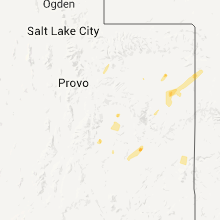
Colorado
| Local Time | Report Details |
|---|---|
| 8:22 PM UTC | Quarter sized hail reported near Simla, CO, 62.2 miles SE of Denver, CO |
| 8:31 PM UTC | Half Dollar sized hail reported near Simla, CO, 64 miles SE of Denver, CO |
| 9:35 PM UTC | Storm damage reported in mesa county CO, 24.5 miles NW of Grand Junction, CO |
| 10:20 PM UTC | Quarter sized hail reported near Elizabeth, CO, 39.2 miles SSE of Denver, CO |
| 11:10 PM UTC | Storm damage reported in rio blanco county CO, 37.4 miles SSW of Craig, CO |
| 12:05 AM UTC | Quarter sized hail reported near Beulah, CO, 18.9 miles SW of Pueblo, CO |
| 12:08 AM UTC | Quarter sized hail reported near Lakewood, CO, 6.9 miles WSW of Denver, CO |
| 12:09 AM UTC | Half Dollar sized hail reported near Lakewood, CO, 6.9 miles WSW of Denver, CO |
| 6:14 PM MDT | Quarter sized hail reported near Denver, CO, 1.6 miles WSW of Denver, CO |
| 12:17 AM UTC | Quarter sized hail reported near Denver, CO, 1.8 miles ESE of Denver, CO |
| 6:20 PM MDT | Quarter sized hail reported near Denver, CO, 1.5 miles SSE of Denver, CO, street flooding |
| 6:24 PM MDT | Half Dollar sized hail reported near Lakewood, CO, 5.4 miles SW of Denver, CO, minor street flooding |
| 6:26 PM MDT | Ping Pong Ball sized hail reported near Denver, CO, 1.5 miles SSE of Denver, CO, significant tree damage |
| 6:34 PM MDT | Half Dollar sized hail reported near Sheridan, CO, 6.3 miles S of Denver, CO |
| 12:40 AM UTC | Quarter sized hail reported near Denver, CO, 4.1 miles SW of Denver, CO |
| 7:00 PM MDT | Quarter sized hail reported near Loveland, CO, 48.6 miles N of Denver, CO |
| 1:10 AM UTC | Quarter sized hail reported near Colorado Springs, CO, 48.6 miles N of Pueblo, CO |
| 1:11 AM UTC | Quarter sized hail reported near Lyons, CO, 41.1 miles NNW of Denver, CO |
| 1:15 AM UTC | Golf Ball sized hail reported near Colorado Springs, CO, 48.9 miles N of Pueblo, CO |
| 1:17 AM UTC | Quarter sized hail reported near Longmont, CO, 38.2 miles NNW of Denver, CO, southwest edge of carter lake |
| 1:25 AM UTC | Quarter sized hail reported near Loveland, CO, 47.8 miles NNW of Denver, CO, north side of carter lake |
| 1:28 AM UTC | Quarter sized hail reported near Loveland, CO, 45.3 miles N of Denver, CO |
| 1:30 AM UTC | Hen Egg sized hail reported near Conifer, CO, 28.9 miles SSW of Denver, CO |
| 1:34 AM UTC | Quarter sized hail reported near Loveland, CO, 47.2 miles N of Denver, CO |
| 1:37 AM UTC | Golf Ball sized hail reported near Loveland, CO, 47.9 miles NNW of Denver, CO |
| 1:38 AM UTC | Half Dollar sized hail reported near Fort Collins, CO, 51.2 miles N of Denver, CO |
| 7:39 PM MDT | Quarter sized hail reported near Loveland, CO, 49.9 miles N of Denver, CO |
| 1:42 AM UTC | Quarter sized hail reported near Fort Collins, CO, 52.7 miles N of Denver, CO |
| 1:43 AM UTC | Half Dollar sized hail reported near Fort Collins, CO, 51.2 miles N of Denver, CO |
| 1:45 AM UTC | Ping Pong Ball sized hail reported near Fort Collins, CO, 53.3 miles N of Denver, CO, warren lake |
| 7:45 PM MDT | Ping Pong Ball sized hail reported near Fort Collins, CO, 52.6 miles N of Denver, CO, broken windows...damaged shingles...shredded leaves and estimated thunderstorm winds upto 50 mph. |
| 1:45 AM UTC | Golf Ball sized hail reported near Fort Collins, CO, 56 miles N of Denver, CO |
| 1:45 AM UTC | Golf Ball sized hail reported near Fort Collins, CO, 51.2 miles N of Denver, CO, shattered house window near college and trilby. |
| 1:49 AM UTC | Quarter sized hail reported near Fort Collins, CO, 52.5 miles N of Denver, CO, sheets of one inch hail with significant tree damage. |
| 7:52 PM MDT | Golf Ball sized hail reported near Loveland, CO, 48.8 miles N of Denver, CO |
| 3:30 AM UTC | Storm damage reported in denver county CO, 19.3 miles ENE of Denver, CO |
| 3:31 AM UTC | Quarter sized hail reported near Denver, CO, 19.3 miles ENE of Denver, CO |
New York
| Local Time | Report Details |
|---|---|
| 8:25 PM UTC | Damage to a roo in dolgeville county NY, 46.5 miles WNW of Schenectady, NY |
| 8:25 PM UTC | Limbs down on otsego stree in mohawk county NY, 53.7 miles NE of Scranton, PA |
| 8:30 PM UTC | Tree on wire on grant roa in russia county NY, 57.2 miles ENE of Syracuse, NY |
| 8:30 PM UTC | Tree down on travis roa in van hornsville county NY, 45.7 miles W of Schenectady, NY |
Kansas
| Local Time | Report Details |
|---|---|
| 8:30 PM UTC | Golf Ball sized hail reported near Colby, KS, 9 miles SE of Colby, KS, also had estimated wind gusts to 70 mph. tree limb damage. |
| 9:30 PM UTC | Golf Ball sized hail reported near Colby, KS, 9 miles SE of Colby, KS, also had estimated wind gusts to 70 mph. tree limb damage.corrected for time. |
| 10:05 PM UTC | Also received nickel-size hai in thomas county KS, 17.6 miles E of Colby, KS |
| 10:45 PM UTC | Quarter sized hail reported near Hoxie, KS, 24.2 miles E of Colby, KS, estimated wind gusts to 50 mph. |
| 12:10 AM UTC | Storm damage reported in graham county KS, 48.3 miles WNW of Hays, KS |
| 12:17 AM UTC | Storm damage reported in graham county KS, 38.5 miles NW of Hays, KS |
| 12:25 AM UTC | Storm damage reported in barber county KS, 62.2 miles NE of Woodward, OK |
| 1:42 AM UTC | Storm damage reported in rooks county KS, 36 miles N of Hays, KS |
Vermont
| Local Time | Report Details |
|---|---|
| 8:41 PM UTC | Quarter sized hail reported near West Rutland, VT, 61.7 miles S of Burlington, VT, quarter size hail |
| 8:55 PM UTC | 10 foot long branch down in rutland county VT, 67 miles NE of Schenectady, NY |
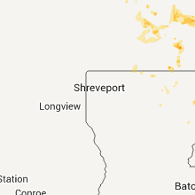
Louisiana
| Local Time | Report Details |
|---|---|
| 9:00 PM UTC | Couple of trees down on old monroe roa in morehouse county LA, 6.1 miles S of Bastrop, LA |
| 12:45 AM UTC | A few trees down on hogue roa in tensas county LA, 58.8 miles WSW of Jackson, MS |
Massachusetts
| Local Time | Report Details |
|---|---|
| 10:30 PM UTC | Tree down blocking walnut plain roa in plymouth county MA, 31.3 miles ESE of Providence, RI |
| 10:30 PM UTC | Trees down on marys pond roa in plymouth county MA, 31.3 miles ESE of Providence, RI |
New Jersey
| Local Time | Report Details |
|---|---|
| 10:34 PM UTC | Tree down on carlton dale road in passaic county NJ, 32.3 miles NNW of Brooklyn, NY |
| 10:34 PM UTC | Tree down on margaret king road in passaic county NJ, 32.3 miles NNW of Brooklyn, NY |
| 10:35 PM UTC | Carnival tent pole blown down across from lenox avenue in passaic county NJ, 26.4 miles NW of Brooklyn, NY |
| 10:40 PM UTC | Tree snapped and fell onto power lines on hilltop court in passaic county NJ, 26.4 miles NW of Brooklyn, NY |
| 10:42 PM UTC | Tree down on house on darlington road in bergen county NJ, 28.5 miles NNW of Brooklyn, NY |
| 10:45 PM UTC | Tree down closing myrtle road and grove street in bergen county NJ, 26.7 miles NNW of Brooklyn, NY |
| 10:50 PM UTC | Tree down on route 202...ramapo valley road...at ramapo college in bergen county NJ, 28.5 miles NNW of Brooklyn, NY |
| 10:50 PM UTC | Tree down on darlington avenue near mahwah border in bergen county NJ, 26.7 miles NNW of Brooklyn, NY |
Nebraska
| Local Time | Report Details |
|---|---|
| 11:13 PM UTC | Golf Ball sized hail reported near Wilsonville, NE, 70.2 miles NE of Colby, KS |
| 11:14 PM UTC | Half Dollar sized hail reported near Wilsonville, NE, 70 miles NE of Colby, KS |
| 12:10 AM UTC | Quarter sized hail reported near Chapman, NE, 11.6 miles NNE of Grand Island, NE |
| 12:37 AM UTC | Ping Pong Ball sized hail reported near Axtell, NE, 52.9 miles SW of Grand Island, NE |
| 1:59 AM UTC | Estimated 50 to 60 miles per hour with nickel size hai in franklin county NE, 51.1 miles SW of Grand Island, NE |
| 3:50 AM UTC | Quarter sized hail reported near Franklin, NE, 65.3 miles SSW of Grand Island, NE |
| 3:52 AM UTC | Tree down on a building in franklin. numerous tree limbs down in tow in franklin county NE, 65.3 miles SSW of Grand Island, NE |
| 4:45 AM UTC | Half Dollar sized hail reported near Callaway, NE, 31.1 miles ENE of North Platte, NE, hail was spiked. delayed report from the late evening of july 13th. |
Texas
| Local Time | Report Details |
|---|---|
| 11:15 PM UTC | Storm damage reported in gray county TX, 54.6 miles ENE of Amarillo, TX |
| 11:23 PM UTC | Storm damage reported in hutchinson county TX, 41.9 miles NE of Amarillo, TX |
New Mexico
| Local Time | Report Details |
|---|---|
| 11:30 PM UTC | Quarter sized hail reported near San Jon, NM, 27.9 miles E of Tucumcari, NM |
| 12:55 AM UTC | Kcao aso in union county NM, 94.3 miles NNE of Tucumcari, NM |
Utah
| Local Time | Report Details |
|---|---|
| 1:30 AM UTC | Dry microburst in utah county UT, 37.5 miles SSE of Salt Lake City, UT |
Minnesota
| Local Time | Report Details |
|---|---|
| 10:15 AM UTC | Golf Ball sized hail reported near Brandon, MN, 67.8 miles N of Montevideo, MN |
Connect with Interactive Hail Maps