

Hail Map for Sunday, July 16, 2023

Number of Impacted Households on 7/16/2023
0
Impacted by 1" or Larger Hail
0
Impacted by 1.75" or Larger Hail
0
Impacted by 2.5" or Larger Hail
Square Miles of Populated Area Impacted on 7/16/2023
0
Impacted by 1" or Larger Hail
0
Impacted by 1.75" or Larger Hail
0
Impacted by 2.5" or Larger Hail


Cities Most Affected by Hail Storms of 7/16/2023
| Hail Size | Demographics of Zip Codes Affected | ||||||
|---|---|---|---|---|---|---|---|
| City | Count | Average | Largest | Pop Density | House Value | Income | Age |
| Great Bend, KS | 6 | 2.25 | 4.00 | 78 | $61k | $33.4k | 38.0 |
| Osborne, KS | 2 | 3.00 | 3.00 | 6 | $37k | $29.6k | 48.3 |
| Rushville, NE | 2 | 1.75 | 1.75 | 1 | $43k | $28.7k | 42.9 |
| Ashby, NE | 1 | 2.50 | 2.50 | 0 | $29k | $47.2k | 46.2 |
| Spearville, KS | 1 | 2.00 | 2.00 | 3 | $66k | $40.3k | 41.7 |
| Ford, KS | 1 | 2.00 | 2.00 | 2 | $32k | $35.2k | 40.9 |
| Pratt, KS | 1 | 1.75 | 1.75 | 28 | $58k | $36.1k | 40.9 |
| Phillipsburg, KS | 1 | 1.75 | 1.75 | 8 | $59k | $37.7k | 44.7 |
| Cedar, KS | 1 | 1.75 | 1.75 | 1 | $64k | $57.7k | 57.3 |
| Waldo, KS | 1 | 1.75 | 1.75 | 1 | $10k | $29.7k | 45.0 |
| Saint John, KS | 1 | 1.75 | 1.75 | 5 | $43k | $33.4k | 45.5 |
| Ellsworth, NE | 1 | 1.75 | 1.75 | 1 | $13k | $31.3k | 43.3 |
| Lake City, KS | 1 | 1.75 | 1.75 | 0 | $23k | $42.8k | 52.8 |
Hail and Wind Damage Spotted on 7/16/2023
Filter by Report Type:Hail ReportsWind Reports
States Impacted
New York, Massachusetts, Connecticut, Pennsylvania, New Hampshire, Kansas, Oklahoma, Texas, Florida, Alabama, Missouri, Louisiana, Arkansas, Georgia, Illinois, South Dakota, Mississippi, Michigan, Nebraska, Wisconsin, Indiana, IowaNew York
| Local Time | Report Details |
|---|---|
| 8:12 AM EDT | Portion of wittenburg road closed near woodstock due to downed tree in ulster county NY, 54 miles S of Schenectady, NY |
| 1:07 PM EDT | Report received at 107 pm of a tree down across rivka road near saugertie in ulster county NY, 47.9 miles S of Schenectady, NY |
| 6:10 PM EDT | Rte 9 nb/sb closed at english rd due to downed tre in saratoga county NY, 11.4 miles NE of Schenectady, NY |
Massachusetts
| Local Time | Report Details |
|---|---|
| 8:35 AM EDT | Tree down on old stage rd - relayed by amateur radi in middlesex county MA, 53.6 miles N of Providence, RI |
| 10:58 AM EDT | Numerous large trees uprooted across tow in worcester county MA, 46.1 miles NW of Providence, RI |
Connecticut
| Local Time | Report Details |
|---|---|
| 8:35 AM EDT | Large tree uprooted per picture on social media. time estimated by rada in hartford county CT, 63.8 miles W of Providence, RI |
| 9:35 AM EDT | Trees down on wires multiple locations - relayed by amateur radi in hartford county CT, 57.3 miles W of Providence, RI |
| 9:40 AM EDT | Tree and wires down on naubuc ave - relayed by amateur radi in hartford county CT, 62 miles W of Providence, RI |
| 10:25 AM EDT | Tree down on wires - relayed by amateur radi in tolland county CT, 39.5 miles WNW of Providence, RI |
Pennsylvania
| Local Time | Report Details |
|---|---|
| 9:54 AM EDT | Picture of trees down along spring lane and hagys mill road. time estimated from rada in philadelphia county PA, 79.5 miles WSW of Brooklyn, NY |
New Hampshire
| Local Time | Report Details |
|---|---|
| 10:00 AM EDT | Branches trees wires down. power outage in rockingham county NH, 59.2 miles SW of Portland, ME |
| 10:00 AM EDT | Delayed report. trees down around lake massabesi in rockingham county NH, 70.2 miles SW of Portland, ME |
| 10:24 AM EDT | Trees down on ridge road near hwy 122. time estimated based on rada in hillsborough county NH, 63.2 miles N of Providence, RI |
| 10:24 AM EDT | Trees down on proctor hill rd as well as near silver lake. time estimated based on rada in hillsborough county NH, 63.4 miles N of Providence, RI |
| 10:30 AM EDT | Downed tree blocking monza roa in hillsborough county NH, 66.8 miles N of Providence, RI |
Kansas
| Local Time | Report Details |
|---|---|
| 9:09 AM CDT | Quarter sized hail reported near Corning, KS, 43.7 miles NE of Manhattan, KS, relayed report from deputy. |
| 3:19 PM CDT | Golf Ball sized hail reported near Phillipsburg, KS, 60.6 miles N of Hays, KS |
| 3:25 PM CDT | Ping Pong Ball sized hail reported near Cedar, KS, 58.4 miles NNE of Hays, KS, social media report of ping pong ball hail in cedar... ks. time estimated from radar. |
| 3:35 PM CDT | Golf Ball sized hail reported near Cedar, KS, 55.6 miles NNE of Hays, KS, delayed report of golf ball size hail that broke windows on home and vehicle and damaged vinyl siding. time estimated from radar. |
| 4:16 PM CDT | Tea Cup sized hail reported near Osborne, KS, 42 miles NE of Hays, KS, this is a corrected location from the earlier issued 3 inch hail report from 7ssw osborne. hail size substantiated by emailed photo since posted on facebook and twitter |
| 4:16 PM CDT | Tea Cup sized hail reported near Osborne, KS, 45.5 miles NE of Hays, KS |
| 4:19 PM CDT | Storm damage reported in osborne county KS, 36.5 miles NE of Hays, KS |
| 4:25 PM CDT | Storm damage reported in russell county KS, 33.8 miles ENE of Hays, KS |
| 4:44 PM CDT | Quarter sized hail reported near Waldo, KS, 33.8 miles ENE of Hays, KS, penny to quarter size hail... covered the ground. |
| 4:44 PM CDT | Golf Ball sized hail reported near Waldo, KS, 33.4 miles ENE of Hays, KS, time verified by radar. |
| 4:58 PM CDT | Half Dollar sized hail reported near Bunker Hill, KS, 32.7 miles ENE of Hays, KS |
| 5:04 PM CDT | Storm damage reported in russell county KS, 27.6 miles E of Hays, KS |
| 5:09 PM CDT | 5 power poles knocked down on homer road from bunker hill to russel in russell county KS, 30.3 miles E of Hays, KS |
| 5:17 PM CDT | Semi overturned at mile marker 189 on interstate 7 in russell county KS, 28.7 miles E of Hays, KS |
| 5:20 PM CDT | All north windows are broken out at a farm. there are large limbs down as well. time is estimate in russell county KS, 36.9 miles E of Hays, KS |
| 5:21 PM CDT | Power lines down blocking the roa in russell county KS, 36.7 miles E of Hays, KS |
| 5:21 PM CDT | Storm damage reported in russell county KS, 28.2 miles E of Hays, KS |
| 5:25 PM CDT | Storm damage reported in russell county KS, 28.2 miles E of Hays, KS |
| 5:28 PM CDT | Large tree limbs dow in russell county KS, 27.6 miles E of Hays, KS |
| 5:34 PM CDT | Quarter sized hail reported near Claflin, KS, 46.7 miles ESE of Hays, KS, pea to dime size. |
| 5:35 PM CDT | Winds were estimated to be 60 to 70 mph. time is estimated from rada in barton county KS, 39.2 miles ESE of Hays, KS |
| 5:52 PM CDT | Sustained 45 to 50 mph with gusts of 55 to 60 mp in barton county KS, 37.2 miles SE of Hays, KS |
| 5:58 PM CDT | Quarter sized hail reported near Great Bend, KS, 46 miles SE of Hays, KS, 600 block of coolidge. |
| 5:59 PM CDT | Golf Ball sized hail reported near Great Bend, KS, 45.2 miles SE of Hays, KS, report from mping: golf ball (1.75 in.). |
| 5:59 PM CDT | Numerous power poles completely snapped. time is estimate in barton county KS, 41.9 miles SE of Hays, KS |
| 6:01 PM CDT | Golf Ball sized hail reported near Great Bend, KS, 45 miles SE of Hays, KS, report from mping: golf ball (1.75 in.). |
| 6:01 PM CDT | Golf Ball sized hail reported near Great Bend, KS, 46 miles SE of Hays, KS |
| 6:02 PM CDT | Golf Ball sized hail reported near Great Bend, KS, 45.2 miles SE of Hays, KS, report from mping: golf ball (1.75 in.). |
| 6:08 PM CDT | Report from mping of trees uprooted or snapped. roof was blown of in barton county KS, 45.2 miles SE of Hays, KS |
| 6:08 PM CDT | Large trees down. 6 inch tree down. also... reported quarter size hai in barton county KS, 47.6 miles SE of Hays, KS |
| 6:08 PM CDT | Part of the roof of a church was torn off in town according to a public report relayed via kake and ksn. time is based on other report in barton county KS, 45.7 miles SE of Hays, KS |
| 6:13 PM CDT | Tennis Ball sized hail reported near Great Bend, KS, 45.3 miles SE of Hays, KS, hen egg to tennis ball size at eisenhower school. |
| 6:15 PM CDT | Grapefruit sized hail reported near Great Bend, KS, 45 miles SE of Hays, KS, report sent via twitter of baseball sized hail with one softball sized piece of hail in the yard. time is based on radar. |
| 6:23 PM CDT | Law enforcement reported multiple power poles blown dow in stafford county KS, 50.9 miles SSE of Hays, KS |
| 6:27 PM CDT | Ping Pong Ball sized hail reported near Albert, KS, 38.1 miles SSE of Hays, KS, twitter picture sent of ping pong ball sized hail. |
| 6:30 PM CDT | Report from mping: 3-inch tree limbs broken; power poles broke in barton county KS, 45.3 miles SE of Hays, KS |
| 6:35 PM CDT | Golf Ball sized hail reported near Saint John, KS, 55.7 miles SSE of Hays, KS, report was received from social media. |
| 6:50 PM CDT | Storm damage reported in pawnee county KS, 49.3 miles SSE of Hays, KS |
| 6:50 PM CDT | Quarter sized hail reported near Larned, KS, 49.3 miles SSE of Hays, KS |
| 6:55 PM CDT | Quarter sized hail reported near Macksville, KS, 65.8 miles SSE of Hays, KS |
| 7:06 PM CDT | 3-inch tree limbs broken... and power poles broken in larne in pawnee county KS, 49.3 miles SSE of Hays, KS |
| 7:25 PM CDT | 4 inch tree limbs broken just south of us 54 and wes river roa in pratt county KS, 78.7 miles W of Wichita, KS |
| 7:30 PM CDT | Ping Pong Ball sized hail reported near Macksville, KS, 66.2 miles SSE of Hays, KS, report received through social media. |
| 7:42 PM CDT | Golf Ball sized hail reported near Pratt, KS, 78.7 miles W of Wichita, KS |
| 8:40 PM CDT | Hen Egg sized hail reported near Spearville, KS, 61.9 miles E of Garden City, KS |
| 8:40 PM CDT | Ping Pong Ball sized hail reported near Spearville, KS, 61.9 miles E of Garden City, KS, report received from social media with pictures. |
| 8:49 PM CDT | Storm damage reported in ford county KS, 61.1 miles ESE of Garden City, KS |
| 8:51 PM CDT | Ping Pong Ball sized hail reported near Wright, KS, 61.1 miles ESE of Garden City, KS |
| 8:55 PM CDT | Quarter sized hail reported near Pratt, KS, 86.9 miles SSE of Hays, KS, report received from social media. |
| 9:07 PM CDT | Hen Egg sized hail reported near Ford, KS, 66.8 miles ESE of Garden City, KS, report received from social media with pictures. |
| 9:13 PM CDT | Quarter sized hail reported near Ford, KS, 68.3 miles ESE of Garden City, KS |
| 9:20 PM CDT | Ping Pong Ball sized hail reported near Ford, KS, 68.3 miles ESE of Garden City, KS |
| 10:05 PM CDT | Golf Ball sized hail reported near Lake City, KS, 70.9 miles NNE of Woodward, OK |
Oklahoma
| Local Time | Report Details |
|---|---|
| 10:22 AM CDT | Measured at durant emergency operations cente in bryan county OK, 34.5 miles SSW of Atoka, OK |
Texas
| Local Time | Report Details |
|---|---|
| 11:00 AM CDT | Trees down and damage to homes in honey grove. time estimated by rada in fannin county TX, 56.9 miles SSE of Atoka, OK |
| 12:32 PM CDT | Large tree down. power lines dow in titus county TX, 91.3 miles SW of Nashville, AR |
| 12:33 PM CDT | Tree down across roa in wood county TX, 88 miles E of Dallas, TX |
| 12:55 PM CDT | Numerous trees down across western upshur count in upshur county TX, 77 miles WNW of Shreveport, LA |
| 1:10 PM CDT | Corrects previous tstm wnd dmg report from 6 ese gilmer. power poles broke in upshur county TX, 65.1 miles WNW of Shreveport, LA |
| 1:14 PM CDT | Shingles blown of in upshur county TX, 70.9 miles WNW of Shreveport, LA |
| 1:37 PM CDT | Scattered trees and power lines were downed across marion count in marion county TX, 45.9 miles WNW of Shreveport, LA |
| 1:40 PM CDT | Trees and power lines down county wid in bowie county TX, 40.8 miles SW of Nashville, AR |
| 1:41 PM CDT | Trees and power lines down county wid in cass county TX, 49.4 miles NW of Shreveport, LA |
| 1:48 PM CDT | Scattered trees and power lines down across mainly northern and eastern harrison count in harrison county TX, 36.2 miles WNW of Shreveport, LA |
| 1:55 PM CDT | Power poles snapped in upshur county TX, 65.1 miles WNW of Shreveport, LA |
Florida
| Local Time | Report Details |
|---|---|
| 12:26 PM CDT | Scattered trees and power lines down in holmes count in holmes county FL, 49.6 miles NE of Miramar Beach, FL |
| 12:50 PM CDT | Tree down along a road at falling waters state par in washington county FL, 55.2 miles ENE of Miramar Beach, FL |
| 2:13 PM EDT | Fhp website reports debris blocking southbound lanes and partially blocking northbound lanes on highway 221 along the taylor-madison county borde in madison county FL, 39.3 miles ESE of Tallahassee, FL |
| 2:45 PM EDT | Tree down near chattahooche in gadsden county FL, 37.9 miles WNW of Tallahassee, FL |
| 2:55 PM EDT | Power lines down on i-10wb mm 20 in leon county FL, 5.5 miles NE of Tallahassee, FL |
| 2:55 PM EDT | Tree blocking road on i-10 eb mm 16 in gadsden county FL, 39.2 miles WNW of Tallahassee, FL |
| 3:44 PM EDT | Lake oke south end sfwm in amz610 county FL, 40.5 miles SW of Port Saint Lucie, FL |
| 3:49 PM EDT | A tree limb fell on a power line and resulted in a power outage near south duval street and bronough stree in leon county FL, 0.7 miles S of Tallahassee, FL |
| 5:59 PM EDT | Pws in sunrise florida at nw 96th ave measured a 58mph gust at 6p in broward county FL, 28.4 miles N of Miami, FL |
| 6:55 PM CDT | Orange trees uproote in okaloosa county FL, 29.9 miles NW of Miramar Beach, FL |
Alabama
| Local Time | Report Details |
|---|---|
| 12:56 PM CDT | Report of a tree falling on a car on county road 85. injuries unknown at this tim in geneva county AL, 67.1 miles NE of Miramar Beach, FL |
Missouri
| Local Time | Report Details |
|---|---|
| 1:00 PM CDT | Tree down on hwy 87 north of eldo in miller county MO, 39.2 miles SSW of Columbia, MO |
| 1:15 PM CDT | Trees down. time based on rada in miller county MO, 53 miles SSW of Columbia, MO |
| 1:49 PM CDT | Two trees down over the roadway... one flag pole pushed into powerline in montgomery county MO, 45 miles E of Columbia, MO |
| 2:21 PM CDT | Storm damage reported in warren county MO, 52.8 miles WNW of Saint Louis, MO |
| 2:24 PM CDT | Tree down on powerline causing outages. time based on radar estimat in laclede county MO, 54.7 miles WNW of Salem, MO |
| 2:40 PM CDT | Power lines down at n second and e main stree in warren county MO, 46.6 miles W of Saint Louis, MO |
| 2:42 PM CDT | Tree down on powerline causing an outage. time based on radar estimat in laclede county MO, 47.6 miles NE of Springfield, MO |
| 2:45 PM CDT | Tree into powerline at wilf flower ln and hwy e in warren county MO, 57.7 miles W of Saint Louis, MO |
| 2:45 PM CDT | Report from mping: 3-inch tree limbs broken; power poles broke in st. charles county MO, 36.7 miles WNW of Saint Louis, MO |
| 2:46 PM CDT | Large tree blown down on a road in town. via picture on faceboo in warren county MO, 46 miles W of Saint Louis, MO |
| 2:55 PM CDT | Numerous trees and power lines down reported by off-duty nws employe in warren county MO, 43.3 miles W of Saint Louis, MO |
| 3:03 PM CDT | Tree blown down and penny sized hail near intersection of highway 94 and highway dd. via facebook pos in st. charles county MO, 30.9 miles W of Saint Louis, MO |
| 3:05 PM CDT | Sign blown over onto a ca in st. charles county MO, 20.6 miles NW of Saint Louis, MO |
| 3:07 PM CDT | Several large tree limbs blown down near intersection of highway 94 and pralle lane. winds estimated around 60 mp in st. charles county MO, 20.1 miles WNW of Saint Louis, MO |
| 3:10 PM CDT | Several large tree limbs blown dow in franklin county MO, 38.4 miles WSW of Saint Louis, MO |
| 3:11 PM CDT | Large tree limb blown down. via picture on twitte in franklin county MO, 43.6 miles WSW of Saint Louis, MO |
| 3:15 PM CDT | Thunderstorm winds snapped off a power pole with the transformer landing in nearby tree. via picture on facebook pos in st. louis county MO, 15.2 miles WNW of Saint Louis, MO |
| 3:19 PM CDT | Storm damage reported in washington county MO, 49.5 miles ENE of Salem, MO |
| 3:27 PM CDT | In tow in jefferson county MO, 38.9 miles SSW of Saint Louis, MO |
| 3:32 PM CDT | Wind estimated 50-60 mph at hampton ave and i-4 in st. louis city county MO, 4.9 miles W of Saint Louis, MO |
| 3:39 PM CDT | Report from mping: 3-inch tree limbs broken; power poles broke in washington county MO, 45.3 miles SW of Saint Louis, MO |
| 3:40 PM CDT | Report from mping: 3-inch tree limbs broken; power poles broke in jefferson county MO, 39.3 miles SSW of Saint Louis, MO |
| 3:41 PM CDT | Report from mping: 3-inch tree limbs broken; power poles broke in st. louis county MO, 14.9 miles SSW of Saint Louis, MO |
| 3:46 PM CDT | Report from mping: 3-inch tree limbs broken; power poles broke in jefferson county MO, 27.2 miles SSW of Saint Louis, MO |
| 3:46 PM CDT | Several large trees and tree limbs blown down around pevely and herculaneum areas. via pictures on faceboo in jefferson county MO, 26.1 miles SSW of Saint Louis, MO |
| 3:52 PM CDT | Large oak tree snapped off. via twitter with pictur in jefferson county MO, 27.4 miles SSW of Saint Louis, MO |
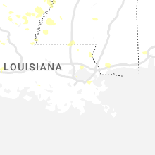
Louisiana
| Local Time | Report Details |
|---|---|
| 2:03 PM CDT | Trees and power lines down on fairfield ave and stephenson s in caddo county LA, 2.4 miles S of Shreveport, LA |
| 2:10 PM CDT | Storm damage reported in caddo county LA, 3.8 miles S of Shreveport, LA |
| 2:13 PM CDT | Trees down across blanchard-furrh road between republic church road and highway 169 near the longwood communit in caddo county LA, 15.1 miles WNW of Shreveport, LA |
| 2:13 PM CDT | *** 1 inj *** a tree fell across highway 169 near blanchard-furrh road near the longwood community... crushing a car with the female driver suffering serious injurie in caddo county LA, 13.9 miles WNW of Shreveport, LA |
| 2:18 PM CDT | Power lines down on wilkinson street between linwood ave and william av in caddo county LA, 1.9 miles SSW of Shreveport, LA |
| 2:19 PM CDT | Trees down onto highway 169 near south lakeshore driv in caddo county LA, 13 miles W of Shreveport, LA |
| 2:27 PM CDT | Tree down across dixie shreveport highway near i-220 eas in caddo county LA, 3.4 miles NNW of Shreveport, LA |
| 2:29 PM CDT | Trees snapped power poles broke in bossier county LA, 8.7 miles N of Shreveport, LA |
| 2:31 PM CDT | Power lines down on garfield driv in caddo county LA, 8.9 miles SSW of Shreveport, LA |
| 2:32 PM CDT | Power lines down on hallmark drive between hallmark circle and hillsboro driv in caddo county LA, 9.6 miles SSW of Shreveport, LA |
| 2:34 PM CDT | Storm damage reported in bossier county LA, 4.5 miles E of Shreveport, LA |
| 2:35 PM CDT | Multiple trees and power lines down in the shady grove subdivision in south bossier cit in bossier county LA, 5.6 miles ESE of Shreveport, LA |
| 2:35 PM CDT | A large tree fell onto a home on parkway drive in bossier cit in bossier county LA, 5.1 miles ESE of Shreveport, LA |
| 2:37 PM CDT | Tree down on power lines in the princeton communit in bossier county LA, 14.2 miles ENE of Shreveport, LA |
| 2:37 PM CDT | Shingles blown of in bossier county LA, 13 miles NNE of Shreveport, LA |
| 2:40 PM CDT | Power poles snapped in webster county LA, 30.8 miles NNE of Shreveport, LA |
| 2:46 PM CDT | Power poles snapped in bossier county LA, 14.4 miles ENE of Shreveport, LA |
| 2:46 PM CDT | Corrects previous tstm wnd dmg report from 4 ene eastwood. tree down on power lines in the princeton communit in bossier county LA, 14.2 miles ENE of Shreveport, LA |
| 3:08 PM CDT | Numerous trees and power lines dow in claiborne county LA, 44.9 miles ENE of Shreveport, LA |
| 3:35 PM CDT | Multiple trees dow in union county LA, 43.4 miles W of Bastrop, LA |
| 3:36 PM CDT | Causeway mesonet measured 68mph wind gus in gmz530 county LA, 17.7 miles N of New Orleans, LA |
| 3:40 PM CDT | 100 foot hotel sign blown down just off exit 85 along interstate twent in lincoln county LA, 45.3 miles WSW of Bastrop, LA |
| 3:40 PM CDT | Numerous trees and power lines were downed in ruston and throughout lincoln parish. much of ruston and choudrant are without powe in lincoln county LA, 45.6 miles WSW of Bastrop, LA |
| 3:45 PM CDT | Numerous trees down across west union paris in union county LA, 41.7 miles WNW of Bastrop, LA |
| 3:59 PM CDT | Numerous trees were downed across much of union parish. some trees fell onto structures and vehicle in union county LA, 28.8 miles W of Bastrop, LA |
| 4:01 PM CDT | A large tree limb was downed onto highway 485 in powhata in natchitoches county LA, 54.8 miles SE of Shreveport, LA |
| 4:11 PM CDT | A tree was blown down across boatner road just south of caney lak in jackson county LA, 54 miles SW of Bastrop, LA |
| 4:18 PM CDT | A tree was downed across highway 546 near leckie roa in ouachita county LA, 32.3 miles SW of Bastrop, LA |
| 4:30 PM CDT | A tree was downed across rowland roa in ouachita county LA, 17.3 miles SSW of Bastrop, LA |
| 4:30 PM CDT | A tree was downed onto a power line on joe white roa in ouachita county LA, 16.5 miles SSW of Bastrop, LA |
| 4:31 PM CDT | A tree was downed in the urania communit in la salle county LA, 66.5 miles SSW of Bastrop, LA |
| 4:31 PM CDT | A tree was downed in oll in la salle county LA, 62.8 miles SSW of Bastrop, LA |
| 4:46 PM CDT | A tree was downed onto power lines on nugent street in jen in la salle county LA, 75.4 miles S of Bastrop, LA |
| 5:00 PM CDT | Numerous trees and power poles were blown down across the parish. damage is being assessed by the catahoula oe in catahoula county LA, 78.6 miles S of Bastrop, LA |
| 5:50 PM CDT | Large branch snapped from thunderstorm outflow. time estimated based on rada in rapides county LA, 64.1 miles NNW of Lafayette, LA |
| 7:25 PM CDT | Several power poles down or leaning. time estimated based on rada in lafayette county LA, 9.8 miles W of Lafayette, LA |
| 7:38 PM CDT | Roof damage to one home. time estimated based on rada in acadia county LA, 10 miles WNW of Lafayette, LA |
Arkansas
| Local Time | Report Details |
|---|---|
| 2:25 PM CDT | Trees and power lines down across southern miller count in miller county AR, 42 miles NNW of Shreveport, LA |
| 2:46 PM CDT | Tree down along county road 22 just south of lewisvill in lafayette county AR, 44.2 miles SSE of Nashville, AR |
| 2:50 PM CDT | 911 dispatch reported a tree down along cr 126 just east of stamp in lafayette county AR, 45.6 miles SSE of Nashville, AR |
| 3:00 PM CDT | Pictures were posted to social media of dozens of trees that were downed in and near emerso in columbia county AR, 51.8 miles NE of Shreveport, LA |
| 3:08 PM CDT | Numerous trees and power lines dow in columbia county AR, 59.1 miles SE of Nashville, AR |
| 3:55 PM CDT | Multiple trees and power lines were downed across union count in union county AR, 52 miles WNW of Bastrop, LA |
| 4:05 PM CDT | Roof damage and trees down in the el dorado... ar are in union county AR, 52.5 miles NW of Bastrop, LA |
Georgia
| Local Time | Report Details |
|---|---|
| 3:40 PM EDT | Two trees were blown down in decatur count in decatur county GA, 31.6 miles NNW of Tallahassee, FL |
| 4:00 PM EDT | Two trees were blown down in grady count in grady county GA, 24.9 miles N of Tallahassee, FL |
| 4:25 PM EDT | Tree down off the intersection of 84 bypass and highway 3 in thomas county georgi in thomas county GA, 34 miles NNE of Tallahassee, FL |
Illinois
| Local Time | Report Details |
|---|---|
| 3:36 PM CDT | Report from mping: 3-inch tree limbs broken; power poles broke in macoupin county IL, 32.8 miles NNE of Saint Louis, MO |
| 4:00 PM CDT | Report from mping: trees uprooted or snappe in st. clair county IL, 12.9 miles ESE of Saint Louis, MO |
| 6:03 PM CDT | At least 10 trees down in williamson count in williamson county IL, 50.4 miles NE of Cape Girardeau, MO |
| 6:18 PM CDT | Large tree split/snapped at the park in harrisbur in saline county IL, 56.3 miles WSW of Evansville, IN |
| 6:23 PM CDT | 11 different calls for trees and powerlines down in harrisburg alon in saline county IL, 55.3 miles WSW of Evansville, IN |
| 6:34 PM CDT | Tree down in the count in pope county IL, 54.8 miles ENE of Cape Girardeau, MO |
South Dakota
| Local Time | Report Details |
|---|---|
| 4:20 PM MDT | Storm damage reported in fall river county SD, 71.2 miles S of Rapid City, SD |
Mississippi
| Local Time | Report Details |
|---|---|
| 5:30 PM CDT | A few trees and power lines were blown down across the northern portion of the count in adams county MS, 81.2 miles SW of Jackson, MS |
| 6:10 PM CDT | Numerous trees were blown down across the count in jefferson county MS, 65.2 miles SW of Jackson, MS |
Michigan
| Local Time | Report Details |
|---|---|
| 5:40 PM CDT | Report on facebook of a tree down on a garage... couple of dead trees down... and small branches on roadways. picture of downed tree was provide in menominee county MI, 65 miles NNE of Green Bay, WI |
Nebraska
| Local Time | Report Details |
|---|---|
| 4:45 PM MDT | Quarter sized hail reported near Chadron, NE, 78.6 miles NNE of Scottsbluff, NE |
| 4:58 PM MDT | Quarter sized hail reported near Chadron, NE, 75.4 miles NNE of Scottsbluff, NE, hail lasted for 1 minute. |
| 5:20 PM MDT | Quarter sized hail reported near Hay Springs, NE, 72.3 miles NE of Scottsbluff, NE, trained spotter reports quarter sized hail... time estimated by radar. |
| 5:45 PM MDT | Golf Ball sized hail reported near Rushville, NE, 76.7 miles NE of Scottsbluff, NE, public reports quarter to golf ball sized hail 13 miles south and 5 east of hay springs. |
| 6:12 PM MDT | Golf Ball sized hail reported near Rushville, NE, 84.6 miles NE of Scottsbluff, NE, public reports golf ball sized hail via social media near rushville. |
| 6:25 PM MDT | Golf Ball sized hail reported near Ellsworth, NE, 72 miles ENE of Scottsbluff, NE, trained spotter reports golf ball sized hail near ellsworth. |
| 6:25 PM MDT | Trained spotter estimates 70 mph wind gust near ellswort in sheridan county NE, 72 miles ENE of Scottsbluff, NE |
| 7:00 PM MDT | Tennis Ball sized hail reported near Ashby, NE, 80.4 miles WNW of North Platte, NE, fire chief/trained spotter reports tennis ball sized hail. |
| 7:00 PM MDT | Fire chief/trained spotter reports thunderstorm damage at local home; broken windows... garden a complete loss... vehicles damaged; ground was completely white from hai in garden county NE, 80.4 miles WNW of North Platte, NE |
Wisconsin
| Local Time | Report Details |
|---|---|
| 6:00 PM CDT | Viewer reported three trees down to local media. time estimated by radar. size of trees unknow in door county WI, 63.9 miles NE of Green Bay, WI |
| 7:45 PM CDT | Corrects time of previous tstm wnd dmg report from menasha. large branches down near smith park. time estimated by rada in winnebago county WI, 30.3 miles SW of Green Bay, WI |
| 7:45 PM CDT | Near oak hill cemetery in neenah. wind speed measured. time estimated by rada in winnebago county WI, 31.3 miles SW of Green Bay, WI |
| 7:53 PM CDT | Very large tree branch downed onto garage. photo via social medi in winnebago county WI, 31.3 miles SW of Green Bay, WI |
| 8:11 PM CDT | Large tree down. pontoon boat overturned at dock on lake wisconsin. time estimated from rada in sauk county WI, 23.9 miles NNW of Madison, WI |
| 8:12 PM CDT | Several trees down in okee. time estimated from rada in columbia county WI, 23.7 miles NNW of Madison, WI |
| 8:16 PM CDT | Quarter sized hail reported near Lodi, WI, 18.5 miles NNW of Madison, WI, time estimated from radar. |
| 8:30 PM CDT | Large branches down near smith park. time estimated by rada in winnebago county WI, 30.3 miles SW of Green Bay, WI |
| 8:45 PM CDT | Power line dow in manitowoc county WI, 33.3 miles SSE of Green Bay, WI |
| 8:45 PM CDT | Power line and pole dow in manitowoc county WI, 26.4 miles SE of Green Bay, WI |
Indiana
| Local Time | Report Details |
|---|---|
| 7:00 PM EDT | Large tree snapped in hal in marion county IN, 13.4 miles NE of Indianapolis, IN |
| 7:03 PM EDT | 1-2 inch diameter branches down. winds estimated 60-65 mph. pea size hai in marion county IN, 7.1 miles N of Indianapolis, IN |
| 7:15 PM EDT | 4 power poles down from storms. time estimated from rada in hancock county IN, 24.5 miles E of Indianapolis, IN |
| 7:31 PM EDT | 4 power poles dow in hancock county IN, 19.7 miles E of Indianapolis, IN |
Iowa
| Local Time | Report Details |
|---|---|
| 5:27 AM CDT | Quarter sized hail reported near Woodbine, IA, 35.4 miles NNE of Omaha, NE, report from mping: quarter (1.00 in.). |
Connect with Interactive Hail Maps