

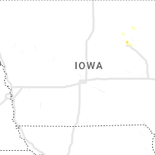
Hail Map for Saturday, July 15, 2023

Number of Impacted Households on 7/15/2023
0
Impacted by 1" or Larger Hail
0
Impacted by 1.75" or Larger Hail
0
Impacted by 2.5" or Larger Hail
Square Miles of Populated Area Impacted on 7/15/2023
0
Impacted by 1" or Larger Hail
0
Impacted by 1.75" or Larger Hail
0
Impacted by 2.5" or Larger Hail


Cities Most Affected by Hail Storms of 7/15/2023
| Hail Size | Demographics of Zip Codes Affected | ||||||
|---|---|---|---|---|---|---|---|
| City | Count | Average | Largest | Pop Density | House Value | Income | Age |
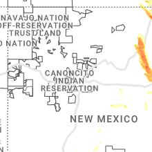
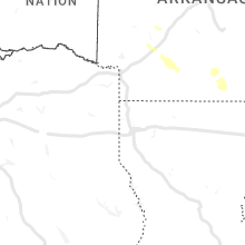
| Wagon Mound, NM | 1 | 2.75 | 2.75 | 0 | $25k | $22.0k | 50.8 |
| Mills, NM | 1 | 2.50 | 2.50 | 0 | $33k | $65.8k | 51.8 |
| Carr, CO | 1 | 2.00 | 2.00 | 2 | $33k | $36.1k | 44.6 |
| Ilfeld, NM | 1 | 1.75 | 1.75 | 0 | $0k | $0.0k | 47.4 |
| Raton, NM | 1 | 1.75 | 1.75 | 6 | $73k | $29.5k | 44.2 |
| Springer, NM | 1 | 1.75 | 1.75 | 0 | $52k | $29.3k | 45.3 |
Hail and Wind Damage Spotted on 7/15/2023
Filter by Report Type:Hail ReportsWind Reports
States Impacted
Ohio, Kentucky, Virginia, Pennsylvania, Tennessee, Wyoming, New Mexico, New Jersey, Colorado, West Virginia, North Carolina, Indiana, Alabama, Florida, Nebraska, Georgia, Arkansas, South Carolina, Maryland, Mississippi, Kansas, Texas, New YorkOhio
| Local Time | Report Details |
|---|---|
| 9:00 AM EDT | Tree limbs downed on springfield pike in woodlawn and wyoming. time estimated from rada in hamilton county OH, 10.1 miles N of Cincinnati, OH |
| 9:07 AM EDT | One tree downed near franklin trenton roa in warren county OH, 32.4 miles NNE of Cincinnati, OH |
| 9:40 AM EDT | Tree downed on price road. time estimated from rada in clermont county OH, 13.1 miles ENE of Cincinnati, OH |
| 1:33 PM EDT | Tree down across road near fourth street east. time estimated from rada in lawrence county OH, 50.2 miles W of Charleston, WV |
| 1:48 PM EDT | Tree down along state route 243 near frys tack shop. time estimated from rada in lawrence county OH, 45.1 miles WNW of Charleston, WV |
| 1:50 PM EDT | Two trees down on gateway big branch road cr 35. time estimated from rada in lawrence county OH, 45.2 miles W of Charleston, WV |
| 3:13 PM EDT | A tree uprooted and minor damage to siding of a gas station on cleveland massillon rd just north of yellow creek r in summit county OH, 23.9 miles S of Cleveland, OH |
| 4:50 PM EDT | Large tree branch 8 inch in diameter snapped on oh-45 on the south side of orwell. several other smaller branches also down in the are in ashtabula county OH, 42.6 miles E of Cleveland, OH |
Kentucky
| Local Time | Report Details |
|---|---|
| 12:52 PM EDT | Tree down across state route 1 near oldtown. time estimated from rada in greenup county KY, 65.4 miles W of Charleston, WV |
Virginia
| Local Time | Report Details |
|---|---|
| 2:20 PM EDT | One tree blown down by thunderstorm winds near the 5900 block of old mountain roa in roanoke county VA, 4.9 miles NNE of Roanoke, VA |
| 2:32 PM EDT | Thunderstorm winds blew down one tree on barnaget roa in roanoke county VA, 4.4 miles NE of Roanoke, VA |
| 4:05 PM EDT | Thunderstorm winds brought down several large tree branches on bedford lake driv in bedford county VA, 29.3 miles ENE of Roanoke, VA |
| 5:00 PM EDT | Thunderstorm winds blew down one tree on beemer trai in bedford county VA, 37.6 miles ENE of Roanoke, VA |
| 5:00 PM EDT | Thunderstorm winds blew down two trees near coleman fall in bedford county VA, 38.1 miles ENE of Roanoke, VA |
| 8:21 PM EDT | Thunderstorm winds blew down two trees along route 20 near muddy cree in buckingham county VA, 47.4 miles W of Richmond, VA |
Pennsylvania
| Local Time | Report Details |
|---|---|
| 3:08 PM EDT | Delayed report... powerlines were down in the area of sunday road and route 611. time estimate in bucks county PA, 63.2 miles W of Brooklyn, NY |
| 3:09 PM EDT | Delayed report... received pictures of several trees down on island road in kintnersville. time estimate in bucks county PA, 63 miles SSE of Scranton, PA |
| 8:04 PM EDT | Reports of trees and wires down near the intersection of mahoning drive and laurel road. time estimated from rada in carbon county PA, 42.7 miles S of Scranton, PA |
| 8:12 PM EDT | Reports of several trees down on laurel drive. time estimated from rada in carbon county PA, 41.9 miles SSW of Scranton, PA |
| 8:15 PM EDT | Several trees down near redners on route 209 in nesquehoning. time estimated from rada in carbon county PA, 38.9 miles SSW of Scranton, PA |
| 8:15 PM EDT | Photo received of trees lying across e white bear drive blocking the road. time estimated from rada in carbon county PA, 41.1 miles SSW of Scranton, PA |
| 8:15 PM EDT | Received photo of trees and wires down at mauch chunk lake. time estimated from rada in carbon county PA, 40 miles S of Scranton, PA |
| 8:16 PM EDT | Reports of multiple trees down in the vicinity of talmar rd. time estimated by rada in columbia county PA, 43.2 miles WSW of Scranton, PA |
| 8:18 PM EDT | Tree down partially blocking lanes of rt 42. time estimated by rada in lycoming county PA, 46.4 miles WSW of Scranton, PA |
| 8:20 PM EDT | Multiple trees down in the biggertown area. time estimated by rada in lycoming county PA, 44.9 miles WSW of Scranton, PA |
| 9:03 PM EDT | Tree down partially blocking us-522. time estimated by rada in fulton county PA, 70.1 miles SSW of State College, PA |
Tennessee
| Local Time | Report Details |
|---|---|
| 3:20 PM EDT | Multiple trees down in rogersvill in hawkins county TN, 45.7 miles WSW of Bristol, TN |
| 4:03 PM EDT | A few trees dow in johnson county TN, 18.5 miles SE of Bristol, TN |
| 5:06 PM EDT | Several reports of trees down. time estimated by rada in sevier county TN, 21.2 miles ESE of Knoxville, TN |
| 5:40 PM EDT | Tree down. 18 inch dimeter trunk of oak tree snappe in hamblen county TN, 34 miles ENE of Knoxville, TN |
| 6:30 PM EDT | Trees down across the county. time estimated by rada in greene county TN, 43.4 miles SW of Bristol, TN |
Wyoming
| Local Time | Report Details |
|---|---|
| 2:10 PM MDT | Half Dollar sized hail reported near Cheyenne, WY, 44.7 miles ESE of Laramie, WY |
| 3:47 PM MDT | Quarter sized hail reported near Cheyenne, WY, 32.7 miles ESE of Laramie, WY, hail ranges from dimes to quarters. |
| 7:45 PM MDT | Quarter sized hail reported near Lingle, WY, 44.4 miles WNW of Scottsbluff, NE, peas to quarter sized hail reported. |
New Mexico
| Local Time | Report Details |
|---|---|
| 2:50 PM MDT | Quarter sized hail reported near Mescalero, NM, 74 miles WSW of Roswell, NM |
| 3:15 PM MDT | Grant co airpor in grant county NM, 11.7 miles SE of Silver City, NM |
| 3:34 PM MDT | Golf Ball sized hail reported near Ilfeld, NM, 66.6 miles ENE of Albuquerque, NM |
| 3:34 PM MDT | Half Dollar sized hail reported near Ilfeld, NM, 66.6 miles ENE of Albuquerque, NM, corrects previous hail report from 2 se south san ysidro. enough hail fell to completely cover the ground to a depth of about 1 inch. |
| 4:10 PM MDT | Mesonet station wsm33 zumwalt track (wsmr in socorro county NM, 109.1 miles ENE of Silver City, NM |
| 4:20 PM MDT | Mesonet station wsm08 harry (wsmr in socorro county NM, 105.1 miles S of Albuquerque, NM |
| 4:23 PM MDT | Quarter sized hail reported near Folsom, NM, 82.5 miles ENE of Taos, NM, quarter sized hail on nm highway 72... 12 miles east of raton. |
| 4:29 PM MDT | Quarter sized hail reported near Wagon Mound, NM, 55.7 miles ESE of Taos, NM, report from mping: quarter (1.00 in.). |
| 4:41 PM MDT | Half Dollar sized hail reported near Wagon Mound, NM, 54.5 miles SE of Taos, NM, report from mping: half dollar (1.25 in.). |
| 4:45 PM MDT | Baseball sized hail reported near Wagon Mound, NM, 55 miles SE of Taos, NM, hard hail broke 3 skylights. hail persisted until approximately 510pm mdt and tapered down to half dollar size before quitting. |
| 6:22 PM MDT | Golf Ball sized hail reported near Raton, NM, 63.6 miles ENE of Taos, NM, golf ball sized hail reported on u.s. highway 64 about 10 miles southwest of raton. |
| 7:42 PM MDT | Quarter sized hail reported near Folsom, NM, 108 miles SSE of Pueblo, CO |
| 7:54 PM MDT | Golf Ball sized hail reported near Springer, NM, 74.2 miles E of Taos, NM, two glass windows broken. |
| 8:28 PM MDT | Tennis Ball sized hail reported near Mills, NM, 66.4 miles NNW of Tucumcari, NM |
New Jersey
| Local Time | Report Details |
|---|---|
| 4:54 PM EDT | Report of trees down in kingston section of south brunswick. time estimated via rada in middlesex county NJ, 38.7 miles SW of Brooklyn, NY |
| 5:27 PM EDT | Tree fell onto a house on montague avenue in ewing. time estimated from rada in mercer county NJ, 53.5 miles WSW of Brooklyn, NY |
| 5:40 AM EDT | Report of trees down on mountainside road in mendham. time estimated via rada in morris county NJ, 33.6 miles W of Brooklyn, NY |
| 5:44 AM EDT | Picture of a large tree down on hopatchung road. time estimated via rada in sussex county NJ, 38.7 miles WNW of Brooklyn, NY |
Colorado
| Local Time | Report Details |
|---|---|
| 3:08 PM MDT | Quarter sized hail reported near Trinidad, CO, 73.4 miles NE of Taos, NM |
| 4:19 PM MDT | Hen Egg sized hail reported near Carr, CO, 48.6 miles SE of Laramie, WY, report via social media. time estimated by radar. |
| 4:46 PM MDT | Quarter sized hail reported near Model, CO, 54.6 miles SE of Pueblo, CO |
| 7:21 PM MDT | Quarter sized hail reported near Colorado Springs, CO, 51 miles N of Pueblo, CO |
| 8:30 PM MDT | Quarter sized hail reported near Wray, CO, 29.3 miles ESE of Yuma, CO, quarter size hail ongoing with winds estimated at 45-50 mph. |
West Virginia
| Local Time | Report Details |
|---|---|
| 5:11 PM EDT | Tree down across poling road near hacker valley. time estimated from rada in webster county WV, 35 miles WSW of Elkins, WV |
| 5:37 PM EDT | Big tree down down clear across kesling mill rd. might be able to fit a car underneath it. time estimated from rada in upshur county WV, 18.1 miles WNW of Elkins, WV |
| 6:01 PM EDT | Tree down along morgantown pike. time estimated from rada in barbour county WV, 8.4 miles NW of Elkins, WV |
| 6:11 PM EDT | Tree and power lines down across mountaineer road rt 38 near moatsville. time estimated from rada in barbour county WV, 18.7 miles N of Elkins, WV |
| 8:03 PM EDT | Multiple trees down in the northern part of mineral county near fort ashby toward the potomac rive in mineral county WV, 70 miles NE of Elkins, WV |
North Carolina
| Local Time | Report Details |
|---|---|
| 5:20 PM EDT | Spotter relayed report of utility lines downed along academy s in rowan county NC, 36.9 miles NNE of Charlotte, NC |
| 5:40 PM EDT | Tree downed along junction r in davie county NC, 45.9 miles NNE of Charlotte, NC |
Indiana
| Local Time | Report Details |
|---|---|
| 4:30 PM CDT | Large tree down blocking 900 n near meridian road. time estimated by rada in porter county IN, 36.7 miles SE of Chicago, IL |
Alabama
| Local Time | Report Details |
|---|---|
| 4:31 PM CDT | Power line down near blac in geneva county AL, 57.6 miles NE of Miramar Beach, FL |
| 4:53 PM CDT | A couple of trees down in the rehobeth are in houston county AL, 76 miles NE of Miramar Beach, FL |
| 5:02 PM CDT | A couple of trees down in the hodgesville are in houston county AL, 76.4 miles NE of Miramar Beach, FL |
Florida
| Local Time | Report Details |
|---|---|
| 4:49 PM CDT | A couple of trees were blown down along highway 8 in walton county FL, 19.7 miles NE of Miramar Beach, FL |
Nebraska
| Local Time | Report Details |
|---|---|
| 5:35 PM CDT | Quarter sized hail reported near Lincoln, NE, 52.7 miles WSW of Omaha, NE, emergency management reported ea to quarter size hail. |
Georgia
| Local Time | Report Details |
|---|---|
| 6:36 PM EDT | Tree down across highway 22 near the hancock county lin in taliaferro county GA, 51.7 miles W of Augusta, GA |
| 6:41 PM EDT | Tree down across interstate 20 near the warren county lin in taliaferro county GA, 49.4 miles W of Augusta, GA |
| 7:09 PM EDT | Mcduffie co 911 reported a tree down on interstate 20 westbound near mile marker 171. time estimate in mcduffie county GA, 31.5 miles W of Augusta, GA |
| 7:15 PM EDT | Mcduffie co 911 reported a tree down on johnson ave near ansley dr in thomson. time estimate in mcduffie county GA, 30.3 miles W of Augusta, GA |
| 7:15 PM EDT | Mcduffie co 911 reported multiple trees downed on cedar rock rd at tanyard creek dr... nw of thomson. time estimate in mcduffie county GA, 32.6 miles W of Augusta, GA |
| 7:18 PM EDT | Mcduffie co 911 reported a tree down on central rd in thomson. exact location not given. time estimate in mcduffie county GA, 30.4 miles W of Augusta, GA |
| 7:19 PM EDT | Tree down along highway 9 in baker county GA, 58.8 miles N of Tallahassee, FL |
| 7:35 PM EDT | Mcduffie co 911 reported a tree down on old milledgeville rd and mt pleasant rd... sw of thomson. time estimate in mcduffie county GA, 32.3 miles W of Augusta, GA |
| 8:11 PM EDT | Tree down along highway 33 south heading towards horse cree in worth county GA, 58.9 miles W of Douglas, GA |
Arkansas
| Local Time | Report Details |
|---|---|
| 5:55 PM CDT | Numerous trees were blown down. time estimated by rada in ouachita county AR, 62.4 miles ESE of Nashville, AR |
| 6:14 PM CDT | Large tree limbs across hwy 335 and power lines dow in union county AR, 57.1 miles NW of Bastrop, LA |
| 6:58 PM CDT | A tree was blown down across highway 5 in ashley county AR, 27 miles N of Bastrop, LA |
| 7:00 PM CDT | Several trees were blown down across multiple roads throughout the count in ashley county AR, 28.8 miles NNE of Bastrop, LA |
| 7:12 PM CDT | Numerous trees and powerlines were blown down in the lake village area. several trees were down across road in chicot county AR, 52.5 miles NE of Bastrop, LA |
South Carolina
| Local Time | Report Details |
|---|---|
| 7:30 PM EDT | County comms received 3 reports of trees downed within the city of greenwood and 3 reports of trees down in the county. location and time approximat in greenwood county SC, 50.5 miles SSE of Greenville, SC |
Maryland
| Local Time | Report Details |
|---|---|
| 7:47 PM EDT | Tree down near intersection of bel alton-newtown rd and mallow rd in charles county MD, 59.5 miles SSW of Baltimore, MD |
| 8:00 PM EDT | Multiple trees down near the intersection of piedmont avenue and columbia avenu in allegany county MD, 76.4 miles NE of Elkins, WV |
| 8:09 PM EDT | Tree down onto house near the 1300 block of redwood circl in charles county MD, 56.2 miles SSW of Baltimore, MD |
| 8:11 PM EDT | Tree onto a house at 1382 redwood circle in charles county MD, 56.2 miles SSW of Baltimore, MD |
| 8:20 PM EDT | Tree down along darley d in charles county MD, 57.2 miles SSW of Baltimore, MD |
| 8:22 PM EDT | Quarter sized hail reported near La Plata, MD, 55.9 miles SSW of Baltimore, MD |
| 8:27 PM EDT | Tree onto house with significant damage along farewell ct. off of mitchell rd in charles county MD, 54.6 miles SSW of Baltimore, MD |
| 8:27 PM EDT | Numerous trees and wires down along mitchell rd in charles county MD, 53.8 miles SSW of Baltimore, MD |
| 8:30 PM EDT | Tree down at 9820 marshall corner rd in charles county MD, 52.1 miles SSW of Baltimore, MD |
| 8:32 PM EDT | Three trees and several branches down on marshall corner roa in charles county MD, 54 miles SSW of Baltimore, MD |
| 8:38 PM EDT | Tree down near intersection of leonardtown rd and forest park dr in charles county MD, 49.7 miles SSW of Baltimore, MD |
| 8:45 PM EDT | Tree down on tollgate ridge road near the state lin in washington county MD, 75.9 miles SSW of State College, PA |
| 8:46 PM EDT | Large tree down onto wires near intersection of fenwick rd and mccrea rd in charles county MD, 52.3 miles SSW of Baltimore, MD |
Mississippi
| Local Time | Report Details |
|---|---|
| 8:53 PM CDT | A tree was blown down across east railroad roa in yazoo county MS, 26 miles NNW of Jackson, MS |
Kansas
| Local Time | Report Details |
|---|---|
| 9:50 PM CDT | Quarter sized hail reported near Saint Francis, KS, 42 miles ESE of Yuma, CO, occurred with estimated gusts of 60 mph. |
| 9:50 PM CDT | Occurred with quarter size hail. the wind and hail lasted about four minutes. the anemometer was damaged by the hai in cheyenne county KS, 42 miles ESE of Yuma, CO |
Texas
| Local Time | Report Details |
|---|---|
| 10:00 PM CDT | Storm damage reported in hartley county TX, 69 miles NW of Amarillo, TX |
| 10:51 PM CDT | Storm damage reported in oldham county TX, 29.9 miles W of Amarillo, TX |
| 11:24 PM CDT | Quarter sized hail reported near Amarillo, TX, 7.8 miles W of Amarillo, TX |
| 12:31 AM CDT | West texas mesonet report in swisher county TX, 32.2 miles S of Amarillo, TX |
| 2:09 AM CDT | Severe gusts continued through 2:11 a in dickens county TX, 48.6 miles ENE of Lubbock, TX |
| 2:22 AM CDT | Storm damage reported in motley county TX, 49.8 miles SW of Childress, TX |
| 3:02 AM CDT | Storm damage reported in king county TX, 61.2 miles SSW of Childress, TX |
| 3:13 AM CDT | Fluvanna mesonet measured 61 mph wind gus in borden county TX, 60.4 miles SE of Lubbock, TX |
| 3:16 AM CDT | Peak wind gust. additional severe gusts occurred between 3:15 am and 3:21 a in cottle county TX, 38.7 miles SSW of Childress, TX |
| 3:49 AM CDT | Snyder 3e mesonet measured 60 mph wind gus in scurry county TX, 67.7 miles WNW of Abilene, TX |
New York
| Local Time | Report Details |
|---|---|
| 6:18 AM EDT | Tree down on wires. town of livingsto in columbia county NY, 47.3 miles SSE of Schenectady, NY |
Connect with Interactive Hail Maps