

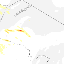
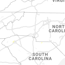
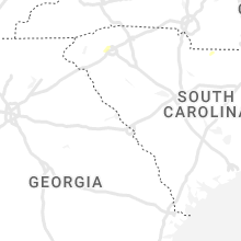
Hail Map for Monday, July 18, 2022

Number of Impacted Households on 7/18/2022
0
Impacted by 1" or Larger Hail
0
Impacted by 1.75" or Larger Hail
0
Impacted by 2.5" or Larger Hail
Square Miles of Populated Area Impacted on 7/18/2022
0
Impacted by 1" or Larger Hail
0
Impacted by 1.75" or Larger Hail
0
Impacted by 2.5" or Larger Hail


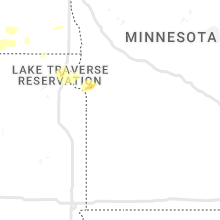


Cities Most Affected by Hail Storms of 7/18/2022
| Hail Size | Demographics of Zip Codes Affected | ||||||
|---|---|---|---|---|---|---|---|
| City | Count | Average | Largest | Pop Density | House Value | Income | Age |
| Lanse, MI | 6 | 2.08 | 2.75 | 15 | $68k | $33.7k | 43.9 |
| Williston, ND | 1 | 2.75 | 2.75 | 25 | $61k | $32.0k | 37.0 |
| Ray, ND | 1 | 1.75 | 1.75 | 2 | $40k | $29.7k | 46.9 |
Hail and Wind Damage Spotted on 7/18/2022
Filter by Report Type:Hail ReportsWind Reports
States Impacted
West Virginia, Montana, Virginia, Tennessee, New Jersey, Minnesota, Maryland, New York, Colorado, South Dakota, New Hampshire, California, Utah, Vermont, South Carolina, North Carolina, Alabama, Wyoming, North Dakota, MichiganWest Virginia
| Local Time | Report Details |
|---|---|
| 12:12 PM EDT | Corrects previous tstm wnd dmg report from coal city. updates previous tstm wnd dmg report from coal city. numerous trees and power lines down in a small area within co in raleigh county WV, 51.8 miles SSE of Charleston, WV |
| 2:28 PM EDT | Wind damage was reported near berkeley. wires and a pole were knocked over near the intersection of us-11 williamsport pike and mid atlantic parkway. a tree blew down n in berkeley county WV, 72.7 miles WNW of Baltimore, MD |
| 2:28 PM EDT | A tree blew down near williamsport pike and weaver l in berkeley county WV, 72.4 miles WNW of Baltimore, MD |
Montana
| Local Time | Report Details |
|---|---|
| 11:45 AM MDT | Quarter sized hail reported near Cut Bank, MT, 88.4 miles ENE of Whitefish, MT, estimated time and hail size based on phone report. |
| 4:15 PM MDT | Quonset hut destroyed; broken 4.5ft diameter tre in phillips county MT, 72.2 miles WSW of Glasgow, MT |
| 4:45 PM MDT | Relayed via faceboo in mccone county MT, 60.6 miles SE of Glasgow, MT |
| 5:20 PM MDT | Measured peak wind gus in valley county MT, 15.5 miles SSE of Glasgow, MT |
| 5:20 PM MDT | Camper overturned in driveway and bounced against the house... with winds over 70 mph estimate in valley county MT, 14.4 miles SSE of Glasgow, MT |
| 5:24 PM MDT | Observed at glasgow aso in valley county MT, 1.3 miles NE of Glasgow, MT |
| 5:35 PM MDT | Measured 62 mph wind gust... a few small branches dow in valley county MT, 10.3 miles SE of Glasgow, MT |
| 5:41 PM MDT | Storm damage reported in valley county MT, 32.8 miles NNE of Glasgow, MT |
| 5:45 PM MDT | Estimated 70 mph wind gust... with dime sized hail and torrential rain of over an inc in valley county MT, 42.2 miles NNE of Glasgow, MT |
| 5:58 PM MDT | Shop leveled with many trees down. winds estimated 80-100 mp in valley county MT, 48.6 miles NNE of Glasgow, MT |
| 6:35 PM MDT | Multiple yard items blown around with estimated wind gusts up to 70 mp in roosevelt county MT, 61.7 miles ENE of Glasgow, MT |
| 7:00 PM MDT | Linear wind damage reported in the vicinity... including at least 15 power poles snappe in daniels county MT, 74.9 miles ENE of Glasgow, MT |
| 8:15 PM MDT | Estimated 50-60 mph winds with pea-sized hai in roosevelt county MT, 42.5 miles WNW of Williston, ND |
Virginia
| Local Time | Report Details |
|---|---|
| 2:33 PM EDT | A tree blew down near conicville rd and senedo r in shenandoah county VA, 62.6 miles E of Elkins, WV |
| 2:44 PM EDT | A tree blew down near the intersection of town hall ave and park rd in edinbur in shenandoah county VA, 69 miles E of Elkins, WV |
| 3:03 PM EDT | A tree blew down near south river rd and octonia r in greene county VA, 71.8 miles NW of Richmond, VA |
| 3:05 PM EDT | Several trees blew down near madison rd and dundee r in greene county VA, 69.9 miles NW of Richmond, VA |
| 3:10 PM EDT | Trees blew down along va-672 lovettsville roa in loudoun county VA, 51 miles W of Baltimore, MD |
| 3:22 PM EDT | A tree blew down near milldale rd and morgan ford r in warren county VA, 84.4 miles WSW of Baltimore, MD |
| 3:46 PM EDT | Trees and wires blew down along us-50 john mosby highway near va-748 sam fred road/melmore plac in loudoun county VA, 63.6 miles WSW of Baltimore, MD |
| 3:50 PM EDT | Trees blew down near the intersection of va-797 mount gilead road and va-704 harmony church roa in loudoun county VA, 55.6 miles WSW of Baltimore, MD |
| 4:38 PM EDT | Numerous trees and a couple of power lines down along virginia highway 61 and along side wolf creek between wolf creek and narrows. radar estimated time of these events in giles county VA, 52.3 miles W of Roanoke, VA |
| 4:43 PM EDT | Tree down on a house on porter road approximately 2 miles west-southwest of narrow in giles county VA, 49.7 miles W of Roanoke, VA |
| 4:52 PM EDT | A couple of trees and power line down in the pearsiburg are in giles county VA, 43.1 miles W of Roanoke, VA |
| 5:35 PM EDT | One tree down across the roadway due to thunderstorm winds near the intersection of gus w nicks boulevard and orange avenu in city of roanoke county VA, 2.1 miles NE of Roanoke, VA |
| 5:40 PM EDT | One tree down in the vicinity of fort chiswell road and brower lan in wythe county VA, 58.9 miles WSW of Roanoke, VA |
| 6:05 PM EDT | Several trees dow in washington county VA, 10.1 miles ENE of Bristol, TN |
| 6:45 PM EDT | Several trees dow in washington county VA, 28.8 miles E of Bristol, TN |
Tennessee
| Local Time | Report Details |
|---|---|
| 2:40 PM EDT | Multiple trees dow in knox county TN, 13.4 miles W of Knoxville, TN |
| 2:45 PM EDT | Multiple trees down across power lines and rr track in knox county TN, 6.7 miles WSW of Knoxville, TN |
| 6:05 PM EDT | Several trees dow in sullivan county TN, 0.6 miles ESE of Bristol, TN |
| 6:40 PM EDT | A few trees dow in johnson county TN, 25 miles ESE of Bristol, TN |
New Jersey
| Local Time | Report Details |
|---|---|
| 2:49 PM EDT | Large tree branch down on wire in bergen county NJ, 13 miles N of Brooklyn, NY |
Minnesota
| Local Time | Report Details |
|---|---|
| 1:49 PM CDT | Trees down on long lake on lake vermilion. delayed report. time estimated from rada in st. louis county MN, 73 miles N of Duluth, MN |
Maryland
| Local Time | Report Details |
|---|---|
| 3:07 PM EDT | Trees blew down near the intersection of broad run road and picnic woods roa in frederick county MD, 53.5 miles W of Baltimore, MD |
| 3:10 PM EDT | A tree blew down onto live wires near old middletown rd and cool crest d in frederick county MD, 50.1 miles W of Baltimore, MD |
| 3:14 PM EDT | Trees blew down on us-40 baltimore national pike near hawbottom roa in frederick county MD, 50.3 miles WNW of Baltimore, MD |
| 3:15 PM EDT | Trees blew down near the intersection of us-15 and basford roa in frederick county MD, 48.3 miles W of Baltimore, MD |
| 3:16 PM EDT | A tree blew down near old camp rd and key parkwa in frederick county MD, 46.9 miles WNW of Baltimore, MD |
| 3:20 PM EDT | Trees blew down on northbound us-15 frederick freeway prior to us-40 west patrick stree in frederick county MD, 45.2 miles W of Baltimore, MD |
| 3:21 PM EDT | A tree blew down near the 630 block of wilson plac in frederick county MD, 44.5 miles WNW of Baltimore, MD |
| 3:22 PM EDT | A tree blew down near the 330 block of n market st in frederic in frederick county MD, 43.8 miles WNW of Baltimore, MD |
| 3:25 PM EDT | Trees and wires blew down in the 7200 block of linganore roa in frederick county MD, 40.3 miles WNW of Baltimore, MD |
| 3:30 PM EDT | Trees and wires blew down near the intersection of prices distillery road and cook brothers roa in frederick county MD, 37.1 miles W of Baltimore, MD |
| 3:30 PM EDT | Trees and wires blew down near the intersection of md-26 liberty road and old liberty roa in frederick county MD, 39.6 miles WNW of Baltimore, MD |
| 3:36 PM EDT | Trees blew down along i-70 baltimore national pike near mile marker 65. in frederick county MD, 33.2 miles W of Baltimore, MD |
| 3:38 PM EDT | A tree blew down near the 8500 block of dollyhyde r in frederick county MD, 34.9 miles WNW of Baltimore, MD |
| 3:45 PM EDT | Trees and wires blew down near the intersection of md-75 walnut street and jones roa in frederick county MD, 36.2 miles WNW of Baltimore, MD |
| 3:45 PM EDT | Trees blew down on westbound i-70 between mile marker 68.0 and exit 62/md-75 green valley roa in frederick county MD, 30.4 miles W of Baltimore, MD |
| 3:50 PM EDT | Large tree limbs blew down... a gutter was blown off... and fencing blew down at a residence in the 7200 block of honeybush driv in carroll county MD, 27 miles WNW of Baltimore, MD |
| 3:55 PM EDT | Tree damage was reported near winfield... including a tree that blew down onto wires in the 3700 block of baker roa in carroll county MD, 26.6 miles WNW of Baltimore, MD |
| 4:00 PM EDT | Trees blew down near the intersection of md-97 washington road and md-26 liberty roa in carroll county MD, 23.5 miles WNW of Baltimore, MD |
| 4:05 PM EDT | Tree damage was reported near gamber... including a tree that blew down in the 4200 block of london bridge roa in carroll county MD, 21.7 miles WNW of Baltimore, MD |
| 4:15 PM EDT | Trees and wires blew down near the intersection of md-482 hampstead mexico road near leisters church roa in carroll county MD, 27.7 miles NW of Baltimore, MD |
| 4:17 PM EDT | Large trees and wires blew down near the intersection of the corral drive and burbank driv in montgomery county MD, 37.7 miles WSW of Baltimore, MD |
| 4:18 PM EDT | A tree blew down onto power lines near the 300 block of garrison forest r in baltimore county MD, 11.5 miles NW of Baltimore, MD |
| 4:20 PM EDT | Trees and wires blew down near the intersection of shiloh road and wellesley cour in carroll county MD, 25.5 miles NNW of Baltimore, MD |
| 4:25 PM EDT | Trees and wires blew down near the intersection of oak street and maple avenu in carroll county MD, 29.3 miles NNW of Baltimore, MD |
| 4:30 PM EDT | A large tree two feet in diameter and numerous large tree limbs blew down near the intersection of international circle and international driv in baltimore county MD, 14.7 miles N of Baltimore, MD |
| 4:32 PM EDT | Trees blew down north of cockeysville... including one onto three cars on dove creek wa in baltimore county MD, 15.9 miles N of Baltimore, MD |
| 4:35 PM EDT | A tree blew down onto a commerical building in the 5500 block of nicholson lan in montgomery county MD, 32 miles WSW of Baltimore, MD |
| 4:45 PM EDT | Tree damage was reported near parkville... including a tree that blew down onto wires near the intersection of opal road and garnet roa in baltimore county MD, 7.2 miles NNE of Baltimore, MD |
| 4:57 PM EDT | A tree blew down near s tollgate rd and singer r in harford county MD, 19.9 miles NE of Baltimore, MD |
| 4:59 PM EDT | Tree reported down on jerusalem road near valley brook driv in harford county MD, 16.6 miles NE of Baltimore, MD |
| 5:02 PM EDT | A tree blew down onto live wires near james run rd and tower r in harford county MD, 25.4 miles NE of Baltimore, MD |
| 5:03 PM EDT | A tree blew down near mill green rd and scarboro r in harford county MD, 30.1 miles NE of Baltimore, MD |
| 6:16 PM EDT | Tree down in millington. time estimated via rada in kent county MD, 41.3 miles E of Baltimore, MD |
| 7:10 PM EDT | Wind gusts of up to 55 knots (63 mph) were measured by a mesonet on salthouse cove lane adjacent to the tidal chester river between 7:10 and 7:15 p in anz539 county MD, 31 miles SE of Baltimore, MD |
| 7:10 PM EDT | Corrects previous tstm wnd gst report from 1 nne queenstown. changed estimated to measured. salthouse cove lane mesonet reports 64 mph gust. weatherflow station. time o in queen anne's county MD, 31.8 miles SE of Baltimore, MD |
| 7:20 PM EDT | Salthouse cove lane gusted to 67 mph. time given in report. weatherflow mesonet statio in queen anne's county MD, 31.8 miles SE of Baltimore, MD |
| 7:26 PM EDT | Trees and wires down on md 304 east/west between safety drive and carville lane. time estimated via rada in queen anne's county MD, 36.4 miles ESE of Baltimore, MD |
New York
| Local Time | Report Details |
|---|---|
| 4:15 PM EDT | Wxflow mesonet buoy at execution rock in anz335 county NY, 18.8 miles NE of Brooklyn, NY |
Colorado
| Local Time | Report Details |
|---|---|
| 2:46 PM MDT | Half Dollar sized hail reported near Trinidad, CO, 77.1 miles NE of Taos, NM |
South Dakota
| Local Time | Report Details |
|---|---|
| 3:33 PM MDT | Storm damage reported in ziebach county SD, 85.5 miles NW of Pierre, SD |
New Hampshire
| Local Time | Report Details |
|---|---|
| 5:50 PM EDT | Large branches and a few trees down on granite rd and nutter rd south of center effingham. time estimated by radar. reported by amateur radi in carroll county NH, 38 miles W of Portland, ME |
| 10:18 PM EDT | Multiple trees and wires down. time estimated by rada in cheshire county NH, 76.1 miles E of Schenectady, NY |
| 10:20 PM EDT | Tree down on wires... time estimated by rada in cheshire county NH, 74.4 miles E of Schenectady, NY |
California
| Local Time | Report Details |
|---|---|
| 3:04 PM PDT | Kdag asos recorded a thunderstorm wind gust of 60 mph from the nn in san bernardino county CA, 54.5 miles NNW of Yucca Valley, CA |
Utah
| Local Time | Report Details |
|---|---|
| 4:50 PM MDT | West granite sensor in tooele county UT, 87.3 miles WSW of Salt Lake City, UT |
| 4:55 PM MDT | West of wildcat mtn sensor in tooele county UT, 85.9 miles WSW of Salt Lake City, UT |
| 5:40 PM MDT | English village sensor in tooele county UT, 57.5 miles SW of Salt Lake City, UT |
Vermont
| Local Time | Report Details |
|---|---|
| 6:52 PM EDT | Trees and property damage from photos received near the intersection of route 17 and 22 in addison county VT, 27.7 miles S of Burlington, VT |
South Carolina
| Local Time | Report Details |
|---|---|
| 7:54 PM EDT | County reports a tree down on ross stree in greenville county SC, 9.7 miles E of Greenville, SC |
North Carolina
| Local Time | Report Details |
|---|---|
| 8:02 PM EDT | One tree down along highway 21 south in the sparta area due to thunderstorm wind in alleghany county NC, 62.2 miles E of Bristol, TN |
Alabama
| Local Time | Report Details |
|---|---|
| 7:20 PM CDT | Crenshaw county ema reported a couple of fallen trees in the 10000 block of petrey hwy. time estimated on rada in crenshaw county AL, 64.6 miles E of Camden, AL |
Wyoming
| Local Time | Report Details |
|---|---|
| 6:24 PM MDT | Storm damage reported in campbell county WY, 50.4 miles NNE of Gillette, WY |
North Dakota
| Local Time | Report Details |
|---|---|
| 9:13 PM CDT | Measured from ndawn statio in divide county ND, 42.9 miles NNW of Williston, ND |
| 9:44 PM CDT | Estimated 60 mph gusts with initial push of wind. time estimated from rada in williams county ND, 26 miles NNW of Williston, ND |
| 9:45 PM CDT | Measured by a personal weather statio in williams county ND, 24.9 miles NNW of Williston, ND |
| 10:07 PM CDT | Gust measured from ndawn mesonet statio in williams county ND, 28.7 miles NNE of Williston, ND |
| 10:20 PM CDT | Em and public report and pictures of significant damage in wildrose. damage includes lots of large trees uprooted and blocking streets... multiple open stand buildings in williams county ND, 39.1 miles NNE of Williston, ND |
| 10:23 PM CDT | Ndawn mesonet statio in divide county ND, 48.3 miles NNE of Williston, ND |
| 10:33 PM CDT | Ndawn station measured sustained 60 mph and a gust to 79 mp in divide county ND, 50.8 miles NNE of Williston, ND |
| 11:05 PM CDT | Time estimated from rada in burke county ND, 74.8 miles NE of Williston, ND |
| 11:09 PM CDT | Us air force weather station 1.5 sw of bowbell in burke county ND, 58.9 miles NW of Minot, ND |
| 11:20 PM CDT | Mesonet station 320989 1 nne bowbells (ndawn in burke county ND, 59.2 miles NW of Minot, ND |
| 11:35 PM CDT | Quarter sized hail reported near Williston, ND, 3.5 miles WNW of Williston, ND, report from mping: quarter (1.00 in.). |
| 11:35 PM CDT | Ping Pong Ball sized hail reported near Williston, ND, 0.4 miles WNW of Williston, ND, ping pong ball sized hail falling at time of report. |
| 11:40 PM CDT | Baseball sized hail reported near Williston, ND, 0.4 miles WNW of Williston, ND, numerous reports of large... damaging hail from the city of williston. public submitted photos show hail ranging generally from golf ball to tennis ball size... with a |
| 12:05 AM CDT | Mesonet station 327380 3 n ray (ndawn). 3 meter wind 60 mph... 10 meter wind 63 mp in williams county ND, 27.2 miles NE of Williston, ND |
| 12:08 AM CDT | Golf Ball sized hail reported near Ray, ND, 23.4 miles ENE of Williston, ND, relayed through broadcast media. report of golf ball sized hail. |
| 12:50 AM CDT | Half Dollar sized hail reported near Powers Lake, ND, 52.7 miles ENE of Williston, ND, relayed through social media. photo of hailstone approximately the size of a half dollar. |
| 2:15 AM CDT | Quarter sized hail reported near Lansford, ND, 27.5 miles N of Minot, ND, report relayed through broadcast media. time estimated based on radar. |
| 2:47 AM CDT | Half Dollar sized hail reported near Minot, ND, 2.6 miles SSW of Minot, ND, report from mping: half dollar (1.25 in.). |
| 3:55 AM CDT | Awos station k06d rolla nd awo in rolette county ND, 63.6 miles NNW of Devils Lake, ND |
| 4:03 AM CDT | Ndawn 10m wind gust of 70mph and 3m wind gust of 60mph in towner county ND, 46 miles NNW of Devils Lake, ND |
| 4:15 AM CDT | Awos station k9d7 cando ap n in towner county ND, 30.7 miles NW of Devils Lake, ND |
| 9:45 AM UTC | Report of tree branches down as large as 5 inches in diameter near maida via social media. time estimated from rada in cavalier county ND, 65.4 miles NNE of Devils Lake, ND |
| 4:55 AM CDT | Awos station kd55 langdon ap n in cavalier county ND, 48.8 miles NNE of Devils Lake, ND |
Michigan
| Local Time | Report Details |
|---|---|
| 11:40 PM EDT | Quarter sized hail reported near Rockland, MI, 76.9 miles N of Rhinelander, WI, got hail for 5 minutes. ending by the end of phone call. |
| 11:40 PM EDT | Half Dollar sized hail reported near Rockland, MI, 76.9 miles N of Rhinelander, WI, facebook comment on largest hail size seen during storm. most were around quarter sized. time estimated by radar. |
| 12:20 AM EDT | Golf Ball sized hail reported near Lanse, MI, 53.4 miles WNW of Marquette, MI, shows a couple of pictures of hail... some golf ball sized in his hand. from facebook. |
| 12:25 AM EDT | Golf Ball sized hail reported near Lanse, MI, 51.3 miles WNW of Marquette, MI, from twitter user. |
| 12:25 AM EDT | Hen Egg sized hail reported near Lanse, MI, 51.3 miles WNW of Marquette, MI, facebook photo of person showing hail stone in hand at least the size of a lime/egg. time estimated by radar. |
| 12:25 AM EDT | Tennis Ball sized hail reported near Lanse, MI, 51.3 miles WNW of Marquette, MI, facebook photo of user holding a large hailstone. measured at 2.5 inch diameter after some melting. time estimated by radar. |
| 12:25 AM EDT | Baseball sized hail reported near Lanse, MI, 51.3 miles WNW of Marquette, MI, facebook photo of hail stone in hand. comments that it was about baseball sized. time estimated by radar. |
| 12:27 AM EDT | Golf Ball sized hail reported near Lanse, MI, 50 miles WNW of Marquette, MI, video and photos from facebook user of the hail. a photo shows golf ball sized hail in hand. |
| 2:33 AM EDT | Facebook user shared pictures of tree down on road and on a primary. power out. time of damage estimated by rada in baraga county MI, 50.7 miles WNW of Marquette, MI |
| 2:55 AM EDT | Quarter sized hail reported near Michigamme, MI, 29.9 miles W of Marquette, MI, facebook comment of hail sizes ranging from pea to quarter. time estimated by radar. |
| 3:19 AM EDT | Quarter sized hail reported near Ishpeming, MI, 19.1 miles WSW of Marquette, MI, picture on facebook showing hail measured via ruler. largest stone between a nickel and quarter. |
| 3:32 AM EDT | Quarter sized hail reported near Ishpeming, MI, 15.1 miles WSW of Marquette, MI, from facebook. |
Connect with Interactive Hail Maps