

Hail Map for Monday, July 25, 2022

Number of Impacted Households on 7/25/2022
0
Impacted by 1" or Larger Hail
0
Impacted by 1.75" or Larger Hail
0
Impacted by 2.5" or Larger Hail
Square Miles of Populated Area Impacted on 7/25/2022
0
Impacted by 1" or Larger Hail
0
Impacted by 1.75" or Larger Hail
0
Impacted by 2.5" or Larger Hail

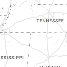


Cities Most Affected by Hail Storms of 7/25/2022
| Hail Size | Demographics of Zip Codes Affected | ||||||
|---|---|---|---|---|---|---|---|
| City | Count | Average | Largest | Pop Density | House Value | Income | Age |
| Charlottesville, VA | 1 | 1.75 | 1.75 | 336 | $178k | $63.7k | 40.5 |
Hail and Wind Damage Spotted on 7/25/2022
Filter by Report Type:Hail ReportsWind Reports
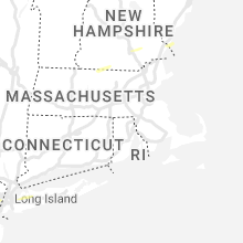
States Impacted
Massachusetts, New Hampshire, Vermont, Virginia, New York, North Carolina, Maryland, District of Columbia, Maine, Colorado, Montana, North Dakota, TennesseeMassachusetts
| Local Time | Report Details |
|---|---|
| 11:15 AM EDT | Tree down in winchendon on hall road. relayed by amateur radi in worcester county MA, 67.3 miles NNW of Providence, RI |
| 4:30 PM EDT | In greenfield... police reported a tree down on cheapside st.... between hope st. and deerfield st. relayed by amateur radi in franklin county MA, 70.8 miles ESE of Schenectady, NY |
| 5:55 PM EDT | In leominster... a shower downed a large branch. street unspecified. report per social medi in worcester county MA, 51.9 miles NNW of Providence, RI |
New Hampshire
| Local Time | Report Details |
|---|---|
| 11:22 AM EDT | Thunderstorms brought down trees and large branches. time estimated by rada in cheshire county NH, 68.3 miles NNW of Providence, RI |
| 1:42 PM EDT | Corrects previous tstm wnd dmg report from 2 n manchester. three trees down on wires on bruce rd... including one on a vehicl in hillsborough county NH, 75 miles SW of Portland, ME |
| 1:48 PM EDT | Multiple utility poles reported down along the londonderry turnpike... closing part of the road. time estimated from rada in rockingham county NH, 73.1 miles SW of Portland, ME |
| 1:52 PM EDT | Tree down on cottage av in rockingham county NH, 72.2 miles SW of Portland, ME |
| 2:13 PM EDT | Tree down on wires on crowley r in rockingham county NH, 67.9 miles SW of Portland, ME |
| 4:49 PM EDT | Quarter sized hail reported near Madison, NH, 47 miles WNW of Portland, ME, trained spotter observing 1 inch hail currently falling in madison on highway 113/conway rd near rock farm lane. |
Vermont
| Local Time | Report Details |
|---|---|
| 12:34 PM EDT | A dozen large trees were down along and near 58 wes in orleans county VT, 43.2 miles NE of Burlington, VT |
Virginia
| Local Time | Report Details |
|---|---|
| 1:14 PM EDT | Thunderstorm winds blew down one tree near the intersection of smith avenue and todd stree in city of radford county VA, 35.9 miles WSW of Roanoke, VA |
| 1:23 PM EDT | Thunderstorm winds blew down one large tree branch near the intersection of industrial park road and south main stree in montgomery county VA, 26 miles WSW of Roanoke, VA |
| 1:24 PM EDT | Thunderstorm winds blew down one large tree branch that took the mirror off a car on gobblers spu in montgomery county VA, 26.4 miles WSW of Roanoke, VA |
| 1:28 PM EDT | Thunderstorm winds blew down a power line along den hill roa in montgomery county VA, 23.6 miles WSW of Roanoke, VA |
| 1:43 PM EDT | Thunderstorm winds blew down multiple tree branches and a shed doo in bedford county VA, 5.6 miles E of Roanoke, VA |
| 2:02 PM EDT | Tree down along highway 460 near the thaxton community center. time estimated from rada in bedford county VA, 19 miles ENE of Roanoke, VA |
| 2:09 PM EDT | Multiple trees and power lines down along hardy road from post office to intersection with wysong mill road at 2:13p in franklin county VA, 9.3 miles ESE of Roanoke, VA |
| 2:18 PM EDT | Couple of trees down along highway 460 in the vicinity of patterson mill road. time estimated from rada in bedford county VA, 20.9 miles ENE of Roanoke, VA |
| 2:20 PM EDT | Large tree blocking all lanes on harveys creek road near intersection with stewartsville road. time estimated from rada in bedford county VA, 19.4 miles E of Roanoke, VA |
| 2:45 PM EDT | Tree down along south old moneta road near downtown moneta drive. time estimated from rada in bedford county VA, 18.8 miles ESE of Roanoke, VA |
| 2:45 PM EDT | Several trees blew down around leesburg... including near the intersection of us-15 james monroe highway and va-740 tutt lan in loudoun county VA, 51.5 miles WSW of Baltimore, MD |
| 2:45 PM EDT | Several trees blew down around leesburg... including near the intersection of us-15 james monroe highway and va-740 tutt lan in loudoun county VA, 51.5 miles WSW of Baltimore, MD |
| 2:47 PM EDT | A tree blew down near rt. 740e and james monroe hwy (us-15)... blocking the roadwa in loudoun county VA, 51.5 miles WSW of Baltimore, MD |
| 2:49 PM EDT | Tree blown down near the intersection of feldspar road and bold branch road. time estimated from rada in bedford county VA, 20.8 miles ESE of Roanoke, VA |
| 2:49 PM EDT | Thunderstorm winds blew down numerous trees along winebarger circl in campbell county VA, 41.5 miles E of Roanoke, VA |
| 2:49 PM EDT | Several trees blown down throughout lynchburg. time estimated from rada in city of lynchburg county VA, 44.7 miles ENE of Roanoke, VA |
| 3:28 PM EDT | Three trees blew down near the 16900 block of north merrimac r in culpeper county VA, 70.6 miles NNW of Richmond, VA |
| 3:28 PM EDT | Trees and large tree limbs blew down near va-719 mountain lake road and bella pointe driv in culpeper county VA, 70.3 miles NNW of Richmond, VA |
| 3:29 PM EDT | Several trees... wires and tree limbs blew down in and near the city of charlottesvill in albemarle county VA, 59 miles NW of Richmond, VA |
| 3:31 PM EDT | A tree blew down near the 200 block of river r in nelson county VA, 68.4 miles WNW of Richmond, VA |
| 3:32 PM EDT | Quarter sized hail reported near Charlottesville, VA, 56.4 miles NW of Richmond, VA, quarter size hail was reported in pantops. |
| 3:32 PM EDT | Trees and large limbs blew down near reva... including in the 2700 block of ridgeview road... blocking the roadwa in madison county VA, 71.2 miles NNW of Richmond, VA |
| 3:34 PM EDT | Quarter sized hail reported near Charlottesville, VA, 56.9 miles NW of Richmond, VA |
| 3:37 PM EDT | Trees and wires blew down near catlett... including along va-604 burwell road in the 8300 bloc in fauquier county VA, 69.2 miles SW of Baltimore, MD |
| 3:40 PM EDT | A wind gust of 58 knots (67 mph) was measured by the awos at warrenton airpor in fauquier county VA, 75 miles N of Richmond, VA |
| 3:40 PM EDT | Trees down in the rockfish/faber area... including along va-6 irish roa in nelson county VA, 65.6 miles WNW of Richmond, VA |
| 3:40 PM EDT | Wires down. time estimate in prince edward county VA, 54.6 miles WSW of Richmond, VA |
| 3:41 PM EDT | Dozens of trees... wires... and large branches blew down just east of charlottesville in the pantops are in albemarle county VA, 57.3 miles NW of Richmond, VA |
| 3:41 PM EDT | Golf Ball sized hail reported near Charlottesville, VA, 56.4 miles NW of Richmond, VA, hail up to golf ball size was reported in pantops. |
| 3:50 PM EDT | Time radar estimated. numerous trees downed in lake monticello with several power outages reported in the are in fluvanna county VA, 47.8 miles NW of Richmond, VA |
| 3:58 PM EDT | Trees blew down near green acre driv in stafford county VA, 69.1 miles N of Richmond, VA |
| 3:59 PM EDT | Over half a dozen trees blown down around charlotte county... with most falling in the charlotte court house are in charlotte county VA, 62.5 miles WSW of Richmond, VA |
| 4:00 PM EDT | Trees downed along prince edward highway with numerous power outages reported between pamplin and ela in prince edward county VA, 53.5 miles WSW of Richmond, VA |
| 4:00 PM EDT | Several large tree limbs blew down around scottsvill in albemarle county VA, 50.3 miles WNW of Richmond, VA |
| 4:05 PM EDT | Tree fell and brought down powerlines... blocking eureka school road entirely. time estimated from rada in charlotte county VA, 59.4 miles WSW of Richmond, VA |
| 4:10 PM EDT | Tree down. time estimate in prince edward county VA, 43.7 miles WSW of Richmond, VA |
| 4:17 PM EDT | Trees downed onto south boston road just north of va-5 in fluvanna county VA, 45.3 miles NW of Richmond, VA |
| 4:18 PM EDT | Trees blew down near the intersection of us-1 richmond highway/jefferson davis highway and va-619 joplin road/fuller roa in prince william county VA, 64.5 miles SW of Baltimore, MD |
| 4:19 PM EDT | A tree blew down near fraley blvd and possum pt rd... blocking the roadwa in prince william county VA, 62.7 miles SW of Baltimore, MD |
| 4:23 PM EDT | Several trees blew down along joplin r in prince william county VA, 65 miles SW of Baltimore, MD |
| 4:28 PM EDT | Tree downed and blocking portion of ontario road. time is radar estimate in lunenburg county VA, 56.1 miles SW of Richmond, VA |
| 4:38 PM EDT | Tree damage was reported near cookstown and spotsylvania courthouse... including along wilderness park driv in spotsylvania county VA, 55.1 miles N of Richmond, VA |
| 4:55 PM EDT | Trees blew down near the intersection of va-655 holly corner road and holly berry roa in stafford county VA, 59.2 miles N of Richmond, VA |
| 5:05 PM EDT | Trees and wires blew down near the intersection of bethany way and va-651 kellog mill roa in stafford county VA, 63.1 miles N of Richmond, VA |
| 5:30 PM EDT | 911 call center reports multiple trees and wires down across hanover county. time estimate in hanover county VA, 20.6 miles NNE of Richmond, VA |
| 5:30 PM EDT | 911 call center reports wires down in multiple locations including the 1900 block of wood st in richmon in city of richmond county VA, 13.1 miles ENE of Richmond, VA |
| 6:04 PM EDT | Trees and wires blew down in the area of rosedale driv in king george county VA, 65.8 miles NNE of Richmond, VA |
| 6:05 PM EDT | Vdot reports road closure due to downed trees blocking roa in richmond county VA, 56.5 miles NE of Richmond, VA |
| 6:05 PM EDT | Vdot reports road closed due to several trees in roa in westmoreland county VA, 66.8 miles NE of Richmond, VA |
| 6:10 PM EDT | Vdot reports lane closure due to tree in roadwa in richmond county VA, 59.1 miles ENE of Richmond, VA |
| 6:20 PM EDT | Vdot reports lane closure due to tree in roadwa in richmond county VA, 57.7 miles ENE of Richmond, VA |
| 6:50 PM EDT | Power outages south of lilian. time estimate in northumberland county VA, 74.2 miles WSW of Ocean City, MD |
| 7:12 PM EDT | Corrects previous marine tstm wind report from 3 sse tangier. wx flow station at tangier sound light reports 67mph wind gus in anz630 county VA, 61.6 miles SW of Ocean City, MD |
New York
| Local Time | Report Details |
|---|---|
| 1:40 PM EDT | Quarter sized hail reported near Roslyn Heights, NY, 20.1 miles ENE of Brooklyn, NY, spotter reports 1 inch hail in roslyn heights. |
| 1:45 PM EDT | Quarter sized hail reported near Woodbury, NY, 27.5 miles ENE of Brooklyn, NY |
| 1:14 AM EDT | Weather station recorded a 64 mph gus in anz335 county NY, 48.7 miles ENE of Brooklyn, NY |
| 1:15 AM EDT | Large tree limbs down and blocking old field roa in suffolk county NY, 48.7 miles ENE of Brooklyn, NY |
North Carolina
| Local Time | Report Details |
|---|---|
| 2:13 PM EDT | One tree and many large limbs blown dow in surry county NC, 77.1 miles N of Charlotte, NC |
| 2:20 PM EDT | One tree reported down north of ellendal in alexander county NC, 55.4 miles NNW of Charlotte, NC |
| 2:25 PM EDT | Numerous trees down. one fell on the carport of house off rockford road. time based on rada in surry county NC, 74.8 miles SW of Roanoke, VA |
| 3:43 PM EDT | One tree reported down off roebuck rd in valdes in burke county NC, 54.6 miles NW of Charlotte, NC |
| 3:55 PM EDT | Tree down along beechnut creek roa in cleveland county NC, 49.6 miles WNW of Charlotte, NC |
| 4:02 PM EDT | One tree down off fingerhut rd north of mountain vie in catawba county NC, 43.5 miles NW of Charlotte, NC |
| 6:35 PM EDT | Trees were reported down on power line in alamance county NC, 41.8 miles WNW of Raleigh, NC |
| 7:37 PM EDT | Trees were reported down along fred royster roa in vance county NC, 41.3 miles NNE of Raleigh, NC |
| 7:37 PM EDT | Trees were reported down along robinson bridge roa in anson county NC, 53.3 miles ESE of Charlotte, NC |
| 7:43 PM EDT | Trees were reported down along st. andrews church roa in vance county NC, 41.4 miles NNE of Raleigh, NC |
| 7:58 PM EDT | Trees were reported down along highway 52 near mcfarlan roa in anson county NC, 54.8 miles ESE of Charlotte, NC |
| 9:23 PM EDT | Trees were reported down on power lines along keelboat lane near royal stree in harnett county NC, 25.5 miles SW of Raleigh, NC |
| 9:42 PM EDT | Power outages from fallen trees and limbs on old stage rd near stone home l in wake county NC, 8 miles S of Raleigh, NC |
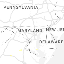
Maryland
| Local Time | Report Details |
|---|---|
| 3:40 PM EDT | Trees blew down in bethesda... including along md-185 connecticut avenue between primrose street and md-191 bradley lan in montgomery county MD, 33.6 miles SW of Baltimore, MD |
| 3:43 PM EDT | Trees blew down in bethesda... including along md-185 connecticut avenue between primrose street and md-191 bradley lan in montgomery county MD, 33.6 miles SW of Baltimore, MD |
| 5:16 PM EDT | A few trees blew down along us-301 between rt 234 and rt 25 in charles county MD, 64.8 miles SSW of Baltimore, MD |
| 5:22 PM EDT | Wind gusts of up to 52 knots (60 mph) were measured by a mesonet on the md-4 thomas johnson bridge (md147) between 5:22 and 5:29 p in calvert county MD, 66.7 miles S of Baltimore, MD |
| 5:29 PM EDT | A wind gust of 52 knots (60 mph) was measured by a mesonet on the md-4 thomas johnson bridge (md147 in calvert county MD, 66.7 miles S of Baltimore, MD |
| 6:10 PM EDT | Tree damage was reported in california... including three trees that blew down along town creek driv in st. marys county MD, 67.9 miles S of Baltimore, MD |
| 6:12 PM EDT | Numerous trees blew down around lexington par in st. marys county MD, 71.6 miles S of Baltimore, MD |
| 6:15 PM EDT | Numerous trees blew down in the great mills and callaway are in st. marys county MD, 72.1 miles S of Baltimore, MD |
| 6:20 PM EDT | Tree down on heritage hill lan in st. marys county MD, 72.5 miles W of Ocean City, MD |
| 6:25 PM EDT | A wind gust of 52 knots (60 mph) was measured by a mesonet on trinity church roa in st. marys county MD, 73.9 miles W of Ocean City, MD |
| 6:42 PM EDT | Wind gusts of up to 56 knots (64 mph) were measured by the point lookout weatherflow sensor (xptl) between 6:42 and 6:48 p in anz537 county MD, 70.3 miles WSW of Ocean City, MD |
| 7:10 PM EDT | Wind gusts of up to 50 knots (58 mph) were measured by the crisfield weatherflow sensor (xcrs) between 7:10 and 7:30 p in anz543 county MD, 50.1 miles WSW of Ocean City, MD |
| 7:10 PM EDT | Multiple trees down in salisbur in wicomico county MD, 26.9 miles W of Ocean City, MD |
| 8:10 PM EDT | Large tree limbs downed along md-12. report via social medi in worcester county MD, 25.6 miles SW of Ocean City, MD |
District of Columbia
| Local Time | Report Details |
|---|---|
| 3:46 PM EDT | Five trees blew down in northeast d in district of columb county DC, 33 miles SW of Baltimore, MD |
Maine
| Local Time | Report Details |
|---|---|
| 5:02 PM EDT | Nws staff member reported trees and wires down on mountain road. time estimated by rada in cumberland county ME, 38.3 miles NW of Portland, ME |
Colorado
| Local Time | Report Details |
|---|---|
| 4:19 PM MDT | Quarter sized hail reported near Colorado Springs, CO, 29.8 miles NNW of Pueblo, CO |
Montana
| Local Time | Report Details |
|---|---|
| 7:30 PM MDT | Mesonet station dcrm8 deep creek raw in glacier county MT, 56.6 miles E of Whitefish, MT |
North Dakota
| Local Time | Report Details |
|---|---|
| 7:50 PM MDT | Nddot site at mannin in dunn county ND, 86.4 miles SSE of Williston, ND |
| 7:50 PM MDT | Ndawn station. this is the 10 meter peak wind gust. 3 meter peak wind gust of 52 mp in stark county ND, 94.2 miles SSE of Williston, ND |
| 8:25 PM MDT | Nddot site at gladstone. 20 minute duration based on observations and rada in stark county ND, 84.1 miles W of Bismarck, ND |
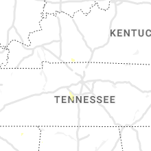
Tennessee
| Local Time | Report Details |
|---|---|
| 10:18 PM EDT | Tree down on post oak valley roa in roane county TN, 40.9 miles W of Knoxville, TN |
Connect with Interactive Hail Maps