

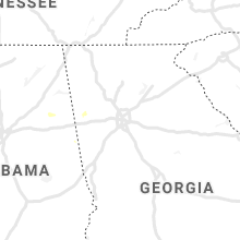
Hail Map for Saturday, July 4, 2020

Number of Impacted Households on 7/4/2020
0
Impacted by 1" or Larger Hail
0
Impacted by 1.75" or Larger Hail
0
Impacted by 2.5" or Larger Hail
Square Miles of Populated Area Impacted on 7/4/2020
0
Impacted by 1" or Larger Hail
0
Impacted by 1.75" or Larger Hail
0
Impacted by 2.5" or Larger Hail


Cities Most Affected by Hail Storms of 7/4/2020
| Hail Size | Demographics of Zip Codes Affected | ||||||
|---|---|---|---|---|---|---|---|
| City | Count | Average | Largest | Pop Density | House Value | Income | Age |
| Jamestown, ND | 1 | 1.75 | 1.75 | 39 | $71k | $33.6k | 42.3 |
| Nashua, MT | 1 | 1.75 | 1.75 | 1 | $39k | $26.9k | 51.6 |
| Tolstoy, SD | 1 | 1.75 | 1.75 | 1 | $33k | $23.3k | 52.0 |
Hail and Wind Damage Spotted on 7/4/2020
Filter by Report Type:Hail ReportsWind Reports
States Impacted
South Dakota, Texas, North Dakota, Florida, Oklahoma, Tennessee, Georgia, Minnesota, Montana, ColoradoSouth Dakota
| Local Time | Report Details |
|---|---|
| 6:05 AM MDT | Quarter sized hail reported near Wakpala, SD, 81.4 miles S of Bismarck, ND, time estimated. |
| 2:20 PM MDT | Quarter sized hail reported near Lead, SD, 28.5 miles WNW of Rapid City, SD |
| 4:01 PM MDT | Quarter sized hail reported near Custer, SD, 28.1 miles SW of Rapid City, SD |
| 5:15 PM MDT | Quarter sized hail reported near Edgemont, SD, 70.3 miles SSW of Rapid City, SD |
| 5:30 PM MDT | Storm damage reported in jackson county SD, 63.6 miles WSW of Pierre, SD |
| 5:37 PM MDT | Storm damage reported in haakon county SD, 65.9 miles WSW of Pierre, SD |
| 5:43 PM MDT | Storm damage reported in haakon county SD, 65.9 miles WSW of Pierre, SD |
| 6:58 PM CDT | Mesonet station 184 eureka (sddot in mcpherson county SD, 47.4 miles WNW of Aberdeen, SD |
| 7:45 PM CDT | Mesonet station ew9368 aberdeen 9 n in brown county SD, 9.3 miles NW of Aberdeen, SD |
| 6:54 PM MDT | Storm damage reported in oglala lakota county SD, 73.7 miles SE of Rapid City, SD |
| 8:18 PM CDT | Damage was also reported at mina lak in edmunds county SD, 11.8 miles W of Aberdeen, SD |
| 8:32 PM CDT | Camper tipped over and evergreen tree snapped. time estimated by rada in edmunds county SD, 13.3 miles W of Aberdeen, SD |
| 9:08 PM CDT | Corrects previous non-tstm wnd dmg report from 5 n chelsea. chemical bulk containers scattered around the farm yar in faulk county SD, 20.1 miles SW of Aberdeen, SD |
| 9:17 PM CDT | Storm damage reported in faulk county SD, 27.6 miles SW of Aberdeen, SD |
| 9:20 PM CDT | Quarter sized hail reported near Bowdle, SD, 65.8 miles W of Aberdeen, SD |
| 9:47 PM CDT | Golf Ball sized hail reported near Tolstoy, SD, 58 miles W of Aberdeen, SD |
| 10:09 PM CDT | Mesonet station 56 tolstoy (sddot in potter county SD, 57.5 miles WSW of Aberdeen, SD |
Texas
| Local Time | Report Details |
|---|---|
| 3:45 PM CDT | Quarter sized hail reported near Pampa, TX, 54.1 miles ENE of Amarillo, TX |
| 3:50 PM CDT | Quarter sized hail reported near Pampa, TX, 54.7 miles ENE of Amarillo, TX |
| 3:52 PM CDT | Ping Pong Ball sized hail reported near Pampa, TX, 54.7 miles ENE of Amarillo, TX, a picture of the hail was sent to our facebook page. |
| 4:23 PM CDT | Storm damage reported in armstrong county TX, 48.5 miles ESE of Amarillo, TX |
| 10:06 PM CDT | Storm damage reported in oldham county TX, 50.9 miles ENE of Tucumcari, NM |
North Dakota
| Local Time | Report Details |
|---|---|
| 3:58 PM CDT | Quarter sized hail reported near Kulm, ND, 65 miles NNW of Aberdeen, SD |
| 4:27 PM CDT | Quarter sized hail reported near Kulm, ND, 60.7 miles NNW of Aberdeen, SD, report received via social media. |
| 4:48 PM CDT | Multiple powerlines and trees down...report confirmed by le dispatcher who added several fires had started from the power lines being down. also nickel to quarter sized in ransom county ND, 52.3 miles SW of Fargo, ND |
| 4:49 PM CDT | Half Dollar sized hail reported near Fredonia, ND, 66.1 miles NNW of Aberdeen, SD, report received via social media. |
| 5:30 PM CDT | Ping Pong Ball sized hail reported near Kulm, ND, 63.5 miles NNW of Aberdeen, SD, report relayed by emergency management. |
| 6:18 PM CDT | Time estimated by radar. strong winds lasted for 45 minute in mcpherson county SD, 35.5 miles NNW of Aberdeen, SD |
| 6:18 PM CDT | Two decent sized trees blown over. numerous smaller branches and limbs also blown down. time estimated from rada in dickey county ND, 36.1 miles NNW of Aberdeen, SD |
| 6:50 PM CDT | Golf Ball sized hail reported near Jamestown, ND, 76.5 miles S of Devils Lake, ND, measured golf ball size hail north of jamestown. |
| 10:55 PM MDT | Storm damage reported in harding county SD, 123.4 miles N of Rapid City, SD |
| 12:34 AM CDT | Asos station kxwa williston airpor in williams county ND, 9.8 miles NW of Williston, ND |
| 12:54 AM CDT | Corrects source for previous tstm wnd gst report from 2 s alamo. ndawn statio in williams county ND, 28.7 miles NNE of Williston, ND |
| 11:55 PM MDT | Raws mesonet station tt584 at williams lookout. time estimated from rada in hettinger county ND, 68.3 miles WSW of Bismarck, ND |
| 1:17 AM CDT | Ndawn station 10-meter wind gust measurement. sustained wind 54 mp in divide county ND, 50.8 miles NNE of Williston, ND |
Florida
| Local Time | Report Details |
|---|---|
| 5:07 PM EDT | Large outdoor contraption consisting of mesh netting well-attached to solid wooden enclosure -- of dimensions around 10-14 feet by 10-14 feet -- fully lofted and tilted in broward county FL, 35.9 miles N of Miami, FL |
Oklahoma
| Local Time | Report Details |
|---|---|
| 4:12 PM CDT | Storm damage reported in jackson county OK, 54.9 miles ENE of Childress, TX |
| 4:15 PM CDT | A metal barn was damaged by thunderstorm wind in jackson county OK, 57.8 miles ENE of Childress, TX |
| 4:20 PM CDT | Storm damage reported in jackson county OK, 54.9 miles ENE of Childress, TX |
Tennessee
| Local Time | Report Details |
|---|---|
| 4:15 PM CDT | Several trees dow in marion county TN, 31.3 miles WNW of Chattanooga, TN |
| 6:35 PM EDT | Severe trees down just east of parrotsville t in cocke county TN, 51.8 miles E of Knoxville, TN |
Georgia
| Local Time | Report Details |
|---|---|
| 6:47 PM EDT | An air traffic controller reported power lines blown down and a power pole snapped near the intersection of highway 20 and i-7 in henry county GA, 25.1 miles SSE of Atlanta, GA |
Minnesota
| Local Time | Report Details |
|---|---|
| 6:16 PM CDT | Half Dollar sized hail reported near Cook, MN, 65.1 miles SE of International Falls, MN, hail accumulated on deck and was enough to shovel. largest hail was bigger than quarter...smaller than golf ball. pine cones and small branches fell from trees. delayed |
| 6:30 PM CDT | Quarter sized hail reported near Wannaska, MN, 17 miles S of Roseau, MN |
| 7:00 PM CDT | Half Dollar sized hail reported near Middle River, MN, 27.9 miles S of Roseau, MN, also very heavy rain with fields and ditches full. |
Montana
| Local Time | Report Details |
|---|---|
| 5:58 PM MDT | Quarter sized hail reported near Stanford, MT, 56.7 miles ESE of Great Falls, MT, picture via twitter of hailstone next to quarter. |
| 6:50 PM MDT | Storm damage reported in powder river county MT, 76.6 miles NNW of Gillette, WY |
| 7:18 PM MDT | Storm damage reported in custer county MT, 2.5 miles NW of Miles City, MT |
| 8:15 PM MDT | Ping Pong Ball sized hail reported near Jordan, MT, 33.5 miles SSE of Glasgow, MT, report relayed with photos from social media. |
| 8:20 PM MDT | Mesonet station kigm8 king coulee. time estimated by rada in valley county MT, 32.6 miles SSW of Glasgow, MT |
| 8:30 PM MDT | Quarter sized hail reported near Nashua, MT, 21.3 miles ESE of Glasgow, MT, hail peas to quarters. |
| 8:35 PM MDT | Golf Ball sized hail reported near Nashua, MT, 21 miles ESE of Glasgow, MT, lots of hail... up to size of golf balls. nearly made the ground white. |
| 8:54 PM MDT | Storm damage reported in carter county MT, 78.4 miles ESE of Miles City, MT |
| 9:05 PM MDT | Off duty nws employee estimates 60 mph wind gusts in fort peck. this has been corroborated with other reports relayed from social medi in valley county MT, 15.8 miles SSE of Glasgow, MT |
| 9:10 PM MDT | Off duty nws employees report branches at least 4 inches in diameter snapped off trees. winds estimated also at 70-80 mph at the same tim in valley county MT, 15.4 miles SE of Glasgow, MT |
| 9:10 PM MDT | Public relayed report of tiles torn off of roof by wind in the duck creek area. time estimated by rada in valley county MT, 15.2 miles SSE of Glasgow, MT |
| 9:24 PM MDT | Damage to the b string on the docks and the c dock at the fort peck marina. relayed via social media. time estimated from rada in valley county MT, 15.7 miles SSE of Glasgow, MT |
| 10:30 PM MDT | Badger creek mesonet station fw2498. sustained winds to 55 mp in richland county MT, 62.6 miles WSW of Williston, ND |
| 10:30 PM MDT | Corrects previous tstm wnd dmg report from 12 nnw enid. large cottonwood tree was uprooted and five copper bottom grain bins were destroye in richland county MT, 60.1 miles WSW of Williston, ND |
| 10:48 PM MDT | Storm damage reported in sheridan county MT, 40.4 miles NW of Williston, ND |
Colorado
| Local Time | Report Details |
|---|---|
| 6:29 PM MDT | Ktad gusted to 58 mp in las animas county CO, 70.1 miles SSE of Pueblo, CO |
Connect with Interactive Hail Maps