

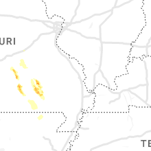
Hail Map for Friday, July 7, 2023

Number of Impacted Households on 7/7/2023
0
Impacted by 1" or Larger Hail
0
Impacted by 1.75" or Larger Hail
0
Impacted by 2.5" or Larger Hail
Square Miles of Populated Area Impacted on 7/7/2023
0
Impacted by 1" or Larger Hail
0
Impacted by 1.75" or Larger Hail
0
Impacted by 2.5" or Larger Hail


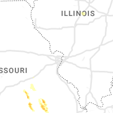


Cities Most Affected by Hail Storms of 7/7/2023
| Hail Size | Demographics of Zip Codes Affected | ||||||
|---|---|---|---|---|---|---|---|
| City | Count | Average | Largest | Pop Density | House Value | Income | Age |
| Cripple Creek, CO | 2 | 1.75 | 1.75 | 4 | $121k | $39.4k | 48.7 |
| Colorado Springs, CO | 1 | 1.75 | 1.75 | 2683 | $126k | $47.2k | 33.1 |
| Ellington, MO | 1 | 1.75 | 1.75 | 8 | $45k | $26.9k | 43.2 |
Hail and Wind Damage Spotted on 7/7/2023
Filter by Report Type:Hail ReportsWind Reports
States Impacted
Oklahoma, New York, Maryland, Vermont, North Dakota, Maine, South Carolina, Virginia, Florida, New Mexico, Pennsylvania, Texas, South Dakota, North Carolina, Colorado, Georgia, Arkansas, MissouriOklahoma
| Local Time | Report Details |
|---|---|
| 7:23 AM CDT | Storm damage reported in kingfisher county OK, 30.9 miles NW of Oklahoma City, OK |
| 7:54 AM CDT | Storm damage reported in comanche county OK, 60.3 miles N of Wichita Falls, TX |
| 8:05 AM CDT | Light pole blown down onto vehicl in cleveland county OK, 10.6 miles S of Oklahoma City, OK |
| 8:06 AM CDT | Kok in oklahoma county OK, 7.2 miles SW of Oklahoma City, OK |
| 8:55 AM CDT | Kdu in stephens county OK, 49.6 miles NE of Wichita Falls, TX |
| 7:57 PM CDT | Brick building reportedly collapsed. time estimated by rada in ellis county OK, 28.8 miles WSW of Woodward, OK |
| 8:45 PM CDT | Storm damage reported in beckham county OK, 74.7 miles S of Woodward, OK |
| 8:45 PM CDT | Storm damage reported in beckham county OK, 74.7 miles S of Woodward, OK |
| 8:50 PM CDT | Storm damage reported in dewey county OK, 27.3 miles S of Woodward, OK |
| 8:50 PM CDT | Storm damage reported in beckham county OK, 69.2 miles S of Woodward, OK |
| 8:50 PM CDT | Storm damage reported in dewey county OK, 28 miles S of Woodward, OK |
| 8:53 PM CDT | Tree down near elk city p in beckham county OK, 70.6 miles S of Woodward, OK |
| 8:55 PM CDT | Storm damage reported in woodward county OK, 1.2 miles WSW of Woodward, OK |
| 8:55 PM CDT | Storm damage reported in woodward county OK, 1.1 miles ENE of Woodward, OK |
| 9:27 PM CDT | Altus af in jackson county OK, 55.4 miles ENE of Childress, TX |
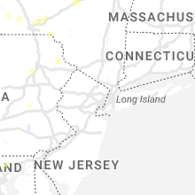
New York
| Local Time | Report Details |
|---|---|
| 11:55 AM EDT | Trees and wires down in wadham in essex county NY, 21.2 miles SW of Burlington, VT |
| 12:28 PM EDT | Trees down... windows blown out... and other property damag in essex county NY, 18.1 miles SSW of Burlington, VT |
| 12:30 PM EDT | A few trees dow in wayne county NY, 32.6 miles WNW of Syracuse, NY |
| 12:30 PM EDT | Trees and wires down between westport and essex from wet microburs in essex county NY, 18.1 miles SSW of Burlington, VT |
| 12:35 PM EDT | Trees and wires down on lake shore roa in essex county NY, 20.1 miles SSW of Burlington, VT |
| 1:53 PM EDT | Trees and wires down according to county dispatch feed... blocking cedar bay road. radar-estimated tim in onondaga county NY, 6 miles E of Syracuse, NY |
| 1:55 PM EDT | Small tree fell down onto an unoccupied little league baseball field and damaged the outfield chainlink fenc in onondaga county NY, 7.1 miles E of Syracuse, NY |
| 2:23 PM EDT | Tree down on road... blocking lane of traffic. via county dispatch feed. radar estimated tim in tompkins county NY, 48 miles SSW of Syracuse, NY |
| 2:33 PM EDT | Trees on wires in essex county NY, 44.5 miles SSW of Burlington, VT |
| 2:41 PM EDT | Tree on wir in warren county NY, 55 miles NNE of Schenectady, NY |
| 2:52 PM EDT | Trees on powerlines. trees on a few vehicles and a hom in warren county NY, 51.9 miles N of Schenectady, NY |
| 3:15 PM EDT | Tree down on river stree in broome county NY, 49.6 miles S of Syracuse, NY |
| 3:16 PM EDT | Wires down on boswell hill roa in broome county NY, 55 miles NNW of Scranton, PA |
| 3:39 PM EDT | Trees on wire in warren county NY, 47.1 miles NNE of Schenectady, NY |
| 3:46 PM EDT | Tree down on route 7 in broome county NY, 57.9 miles N of Scranton, PA |
| 4:02 PM EDT | Trees and wires dow in washington county NY, 45.3 miles NNE of Schenectady, NY |
| 4:12 PM EDT | Tree down on wires on pleasant ave near main s in chenango county NY, 57 miles N of Scranton, PA |
| 4:23 PM EDT | Trees on wire in warren county NY, 49.3 miles SSW of Burlington, VT |
Maryland
| Local Time | Report Details |
|---|---|
| 11:59 AM EDT | Large tree down near the 10600 block of delfield cour in howard county MD, 17.5 miles SW of Baltimore, MD |
| 1:03 PM EDT | One large tree down and multiple large limbs down near the 1900 block of parkwood driv in harford county MD, 20.7 miles NNE of Baltimore, MD |
Vermont
| Local Time | Report Details |
|---|---|
| 12:17 PM EDT | Trees on wires near the intersection of route 12 and keyser roa in washington county VT, 34.1 miles ESE of Burlington, VT |
| 12:30 PM EDT | Wet microburst occurred near worcester with multiple reports of trees down by coop observe in washington county VT, 33.6 miles ESE of Burlington, VT |
| 12:36 PM EDT | Several trees down near green river reservoi in lamoille county VT, 34.3 miles ENE of Burlington, VT |
| 12:41 PM EDT | Down trees and wires on vermont route 1 in washington county VT, 39.3 miles E of Burlington, VT |
| 12:42 PM EDT | Tree down in lamoille county VT, 35.8 miles ENE of Burlington, VT |
| 1:20 PM EDT | Trees down in sutton villag in caledonia county VT, 59.8 miles ENE of Burlington, VT |
| 1:30 PM EDT | Quarter sized hail reported near Danville, VT, 55.7 miles E of Burlington, VT |
| 1:30 PM EDT | Multiple fire calls for trees and wires down near danvill in caledonia county VT, 55.7 miles E of Burlington, VT |
| 1:48 PM EDT | 2nd downburst caused a down tree on power lines and produced additional power outage in caledonia county VT, 53.7 miles E of Burlington, VT |
North Dakota
| Local Time | Report Details |
|---|---|
| 1:27 PM CDT | Quarter sized hail reported near Kulm, ND, 60.6 miles NNW of Aberdeen, SD |
Maine
| Local Time | Report Details |
|---|---|
| 2:36 PM EDT | Tree down on power line in garfield plantation. time estimated based on rada in aroostook county ME, 27.5 miles SW of Caribou, ME |
South Carolina
| Local Time | Report Details |
|---|---|
| 3:00 PM EDT | Tree down near the intersection of flint hill dr and n glassy mountain r in pickens county SC, 7 miles NNW of Greenville, SC |
| 4:58 PM EDT | Corrects previous tstm wnd dmg report from 1 sse oak grove. corrects previous tstm wnd dmg report from 1 sse oak grove. public report via social media with pictures. tr in lexington county SC, 58.8 miles NE of Augusta, GA |
| 6:05 PM EDT | Trained storm spotters reports estimated 60 mph winds near the intersection of hard scrabble road and lake carolina blvd. time estimated from rada in richland county SC, 71.9 miles S of Charlotte, NC |
| 6:15 PM EDT | Tree limb fell onto residential power line resulted in a local power outag in marion county SC, 76.7 miles NNE of Charleston, SC |
Virginia
| Local Time | Report Details |
|---|---|
| 3:21 PM EDT | Multiple trees down onto powerlines around owens drive in dahlgre in king george county VA, 67.1 miles NNE of Richmond, VA |
| 3:33 PM EDT | Multiple trees down onto powerlines near ridge roa in king george county VA, 61.4 miles NNE of Richmond, VA |
| 3:35 PM EDT | Multiple trees down on powerlines in the area around good hope roa in king george county VA, 62.2 miles NNE of Richmond, VA |
| 4:56 PM EDT | Multiple large trees down near the 2100 block of s f t valley roa in madison county VA, 75.6 miles NNW of Richmond, VA |
| 5:05 PM EDT | Tree downed on foxes tract roa in king william county VA, 43.1 miles E of Richmond, VA |
| 5:09 PM EDT | Large tree down near the 3900 block of hebron valley road in madison county VA, 73 miles NNW of Richmond, VA |
| 5:50 PM EDT | Corrects previous tstm wind dmg report from 3 ese rose garden for time. tree downed on foxes tract roa in king william county VA, 43.1 miles E of Richmond, VA |
| 6:09 PM EDT | Large tree down on the road near the intersection of stony point road and echo valley roa in albemarle county VA, 57.3 miles NW of Richmond, VA |
| 6:45 PM EDT | Tree limbs downed onto power lines at west green springs road. numerous power outages reported due to thunderstorm in louisa county VA, 46.4 miles NW of Richmond, VA |
| 7:30 PM EDT | Tree limbs downed on cloverdale road. utility outage map also shows several power outages due to storm in the area. time is estimate in fluvanna county VA, 36.7 miles WNW of Richmond, VA |
| 7:30 PM EDT | Trees downed along cartersville road at va-45. time estimate in cumberland county VA, 27.9 miles WNW of Richmond, VA |
| 7:34 PM EDT | Corrects previous tstm wnd dmg report from 2 wsw new canton. numerous trees and power lines down across the eastern portion of the county beginning at arvonia and conti in buckingham county VA, 39.4 miles WNW of Richmond, VA |
| 7:34 PM EDT | Corrects previous tstm wnd dmg report from 2 wsw new canton. numerous trees and power lines down across the eastern portion of the county beginning at arvonia and conti in buckingham county VA, 39.4 miles WNW of Richmond, VA |
| 7:48 PM EDT | Tree down blocking route 61 in buckingham county VA, 40.3 miles WNW of Richmond, VA |
| 8:09 PM EDT | Trees down along e james anderson hw in buckingham county VA, 39 miles W of Richmond, VA |
| 8:16 PM EDT | Trees down along claybank roa in buckingham county VA, 38.9 miles W of Richmond, VA |
| 8:22 PM EDT | Trees downed in numerous locations along anderson and cumberland roads in the western portion of cumberland county. numerous power outages reported county wide. time es in cumberland county VA, 38.2 miles W of Richmond, VA |
| 8:29 PM EDT | Trees down along plank roa in buckingham county VA, 42.1 miles W of Richmond, VA |
| 8:43 PM EDT | Trees down along s james madison highwa in buckingham county VA, 47 miles W of Richmond, VA |
Florida
| Local Time | Report Details |
|---|---|
| 3:39 PM EDT | Delayed report. three trees down across terrell road near the jacksonville international airport. time estimated by radar downburst signatur in duval county FL, 10.3 miles N of Jacksonville, FL |
| 4:23 PM EDT | Fhp reports power line down on roadway near bluebird lane and summerwood driv in wakulla county FL, 13.9 miles S of Tallahassee, FL |
| 4:36 PM EDT | Duke energy reports power outages near newport due to tree damag in wakulla county FL, 14.9 miles SSE of Tallahassee, FL |
| 5:03 PM EDT | Tree down along upper cody roa in jefferson county FL, 18.1 miles ESE of Tallahassee, FL |
| 5:16 PM EDT | Tree down on power line along sundown creek roa in madison county FL, 45.5 miles E of Tallahassee, FL |
| 5:32 PM EDT | Power line down along county road 25 in lafayette county FL, 62.4 miles ESE of Tallahassee, FL |
| 5:38 PM EDT | Duke energy reports power outages on the northeast side of perry due to tree damag in taylor county FL, 45.1 miles ESE of Tallahassee, FL |
| 5:42 PM EDT | Tree on power line on paul poppell roa in taylor county FL, 43.3 miles ESE of Tallahassee, FL |
| 5:45 PM EDT | Tree damage reported along sr in madison county FL, 57.9 miles E of Tallahassee, FL |
| 6:10 PM EDT | Tree down on power lin in putnam county FL, 59.3 miles S of Jacksonville, FL |
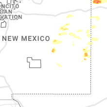
New Mexico
| Local Time | Report Details |
|---|---|
| 2:27 PM MDT | Awos station k4mr 12 se tola in roosevelt county NM, 60.7 miles S of Tucumcari, NM |
| 3:12 PM MDT | Quarter sized hail reported near Hagerman, NM, 18.3 miles S of Roswell, NM |
| 3:15 PM MDT | Quarter sized hail reported near Clayton, NM, 92.7 miles NNE of Tucumcari, NM |
| 3:28 PM MDT | Awos station kcvn clovis muni airpor in curry county NM, 64.2 miles SE of Tucumcari, NM |
| 3:45 PM MDT | Near white out conditions with hail fallin in roosevelt county NM, 70.4 miles ENE of Roswell, NM |
| 4:10 PM MDT | Mesonet station svan5 se vaugh in guadalupe county NM, 81.4 miles NNW of Roswell, NM |
Pennsylvania
| Local Time | Report Details |
|---|---|
| 4:32 PM EDT | Trees down blocking roadway. time estimated by rada in luzerne county PA, 9.5 miles SW of Scranton, PA |
| 5:03 PM EDT | Trees down blocking roadway. time estimated by rada in luzerne county PA, 11.3 miles SSW of Scranton, PA |
| 5:32 PM EDT | Corrects the time previous tstm wnd dmg report from west pittston. trees down blocking roadway. time estimated by rada in luzerne county PA, 9.5 miles SW of Scranton, PA |
| 6:03 PM EDT | Corrects the time from previous tstm wnd dmg report from 2 se westminister. trees down blocking roadway. time estimated by rada in luzerne county PA, 11.3 miles SSW of Scranton, PA |
| 6:31 PM EDT | Trees and wires down along route 6. time estimated by rada in wayne county PA, 19.9 miles NE of Scranton, PA |
| 6:49 PM EDT | Wires down on rutter roa in dauphin county PA, 56.9 miles ESE of State College, PA |
Texas
| Local Time | Report Details |
|---|---|
| 3:35 PM CDT | From 1535cdt through 1550cdt the asos in dalhart gusted 58 to 64 mph from a line of thunderstorms moving throug in hartley county TX, 69 miles NW of Amarillo, TX |
| 4:35 PM CDT | Corrects previous tstm wnd gst report from 3 sw dalhart. from 1635cdt through 1650cdt the asos in dalhart gusted 58 to 64 mph from a line of thunderstorms moving throug in hartley county TX, 69 miles NW of Amarillo, TX |
| 4:55 PM CDT | West texas mesonet report in parmer county TX, 61.9 miles SW of Amarillo, TX |
| 5:34 PM CDT | West texas mesonet report. multiple severe gusts from 5:25p to 5:38 in castro county TX, 51 miles SSW of Amarillo, TX |
| 5:36 PM CDT | West texas mesonet report. multiple severe wind gusts from 5:35p to 5:40 in lamb county TX, 43 miles NW of Lubbock, TX |
| 5:38 PM CDT | Mesonet station near sunray measured multiple wind gusts between 58 and 61 mph between 1738cdt and 1747cd in sherman county TX, 64.4 miles N of Amarillo, TX |
| 5:47 PM CDT | West texas mesonet repor in lamb county TX, 37.5 miles NNW of Lubbock, TX |
| 5:49 PM CDT | Storm damage reported in oldham county TX, 33.2 miles NW of Amarillo, TX |
| 5:57 PM CDT | West texas mesonet repor in castro county TX, 56.5 miles SSW of Amarillo, TX |
| 6:04 PM CDT | Mesonet measured 66 mph wind gust at 1804cdt and peaked at 69 mph at 1806cdt. still gusting upwards of 64 mph at 1810cd in hutchinson county TX, 48.7 miles NNE of Amarillo, TX |
| 6:10 PM CDT | Storm damage reported in potter county TX, 15.6 miles NNW of Amarillo, TX |
| 6:11 PM CDT | Storm damage reported in hutchinson county TX, 44.7 miles NE of Amarillo, TX |
| 6:11 PM CDT | Metal fence blown out into roadwa in hutchinson county TX, 41.1 miles NE of Amarillo, TX |
| 6:13 PM CDT | Storm damage reported in hutchinson county TX, 42.2 miles NE of Amarillo, TX |
| 6:15 PM CDT | Large tree branches down by intersection near sam houston par in potter county TX, 2.6 miles W of Amarillo, TX |
| 6:18 PM CDT | Multiple wind gusts in excess of 58 mph measured by the mesonet located 9 nne of amarill in potter county TX, 9.2 miles N of Amarillo, TX |
| 6:26 PM CDT | West texas mesonet report. additional severe gust to 61 mph at 6:27 in hockley county TX, 21.5 miles WNW of Lubbock, TX |
| 6:32 PM CDT | West texas mesonet report. additional severe gust at 6:13 in swisher county TX, 46.3 miles S of Amarillo, TX |
| 6:35 PM CDT | Storm damage reported in hansford county TX, 78.6 miles NNE of Amarillo, TX |
| 6:39 PM CDT | First gust of 61 mph at 1839cdt... gust picked back up to 61 at 1848cdt. peak gust of 65 mph was at 1849cdt and last 61 mph wind gust was at 1850cd in carson county TX, 13.1 miles ENE of Amarillo, TX |
| 6:40 PM CDT | First severe wind gust of 59 mph was at 1840cdt. peak wind gust of 61 mph was at 1852cdt. last 60 mph wind gust was at 1857cd in gray county TX, 56 miles ENE of Amarillo, TX |
| 6:40 PM CDT | West texas mesonet repor in hale county TX, 20.6 miles NNE of Lubbock, TX |
| 6:40 PM CDT | Storm damage reported in carson county TX, 17.8 miles ENE of Amarillo, TX |
| 6:54 PM CDT | West texas mesonet repor in hockley county TX, 29.4 miles W of Lubbock, TX |
| 6:55 PM CDT | Storm damage reported in hockley county TX, 29.8 miles W of Lubbock, TX |
| 7:09 PM CDT | Storm damage reported in lubbock county TX, 13.8 miles SW of Lubbock, TX |
| 7:10 PM CDT | Storm damage reported in gray county TX, 52.9 miles E of Amarillo, TX |
| 7:11 PM CDT | Storm damage reported in armstrong county TX, 38.5 miles ESE of Amarillo, TX |
| 7:22 PM CDT | Storm damage reported in hemphill county TX, 77.6 miles SW of Woodward, OK |
| 7:27 PM CDT | Mesonet gusted to 76 mph at 1927cdt... and quickly measured a 95 and 96 mph gust over the next two minute. last gust of 61 mph was at 1935cd in lipscomb county TX, 58.3 miles WSW of Woodward, OK |
| 8:06 PM CDT | Storm damage reported in gray county TX, 59.5 miles NNW of Childress, TX |
| 8:16 PM CDT | First wind gust was 66 mph at 2016cdt. a gust of 73 mph was measured at 2018cdt. the mesonet measured an even higher wind gust of 76 mph at 2025cdt and continued to gus in collingsworth county TX, 25.1 miles N of Childress, TX |
| 8:24 PM CDT | 59 mph wind gusts were reported at 824 and 827 pm cdt at the post west texas mesonet sit in garza county TX, 39 miles SE of Lubbock, TX |
| 9:55 PM CDT | Wilbarger county airpor in wilbarger county TX, 50.1 miles WNW of Wichita Falls, TX |
| 10:51 PM CDT | Storm damage reported in cochran county TX, 45.7 miles WSW of Lubbock, TX |
| 11:46 PM CDT | Storm damage reported in lubbock county TX, 11.3 miles W of Lubbock, TX |
| 11:48 PM CDT | Storm damage reported in lubbock county TX, 16.3 miles SW of Lubbock, TX |
| 11:57 PM CDT | Storm damage reported in lubbock county TX, 11.3 miles W of Lubbock, TX |
| 11:57 PM CDT | Storm damage reported in lubbock county TX, 4.5 miles SE of Lubbock, TX |
| 12:05 AM CDT | Storm damage reported in lubbock county TX, 6.5 miles SSW of Lubbock, TX |
South Dakota
| Local Time | Report Details |
|---|---|
| 4:11 PM CDT | Quarter sized hail reported near Eureka, SD, 56.5 miles WNW of Aberdeen, SD, photo of nickel to quarter sized hail. |
North Carolina
| Local Time | Report Details |
|---|---|
| 5:13 PM EDT | Multiple trees and powerlines down. a house was moved off of its foundatio in franklin county NC, 39 miles NE of Raleigh, NC |
| 5:28 PM EDT | Fallen trees or limbs damaged power equipmen in wake county NC, 9.6 miles NW of Raleigh, NC |
| 5:36 PM EDT | Large tree down near/on a house. time estimated by rada in nash county NC, 31.7 miles ENE of Raleigh, NC |
| 5:39 PM EDT | Fallen trees or limbs damaged power equipmen in nash county NC, 32.5 miles ENE of Raleigh, NC |
| 5:45 PM EDT | Tree downed on gliden road. time estimate in chowan county NC, 42.9 miles SW of Virginia Beach, VA |
| 6:32 PM EDT | 1 downed tre in johnston county NC, 15.5 miles SE of Raleigh, NC |
| 6:39 PM EDT | Fallen trees or limbs damaged power equipmen in wayne county NC, 44.3 miles ESE of Raleigh, NC |
| 6:48 PM EDT | Quarter sized hail reported near Goldsboro, NC, 49.9 miles ESE of Raleigh, NC, report from mping: quarter sized hail (1.00 in.). |
| 6:50 PM EDT | Fallen trees or limbs damaged power equipmen in johnston county NC, 27.5 miles SSE of Raleigh, NC |
| 6:57 PM EDT | 1 downed tre in johnston county NC, 27.9 miles SSE of Raleigh, NC |
| 7:05 PM EDT | Fallen trees or limbs damaged power equipmen in wake county NC, 16.5 miles SSW of Raleigh, NC |
| 7:18 PM EDT | Quarter sized hail reported near Fuquay Varina, NC, 18 miles SSW of Raleigh, NC |
| 7:20 PM EDT | Half Dollar sized hail reported near Fuquay Varina, NC, 16.4 miles SSW of Raleigh, NC |
| 7:25 PM EDT | Tree down blocking highway 87 east near intersection with airport road in council... nc. time estimated based on radar. lightning strike damage possibl in bladen county NC, 38.4 miles NW of Wilmington, NC |
| 8:09 PM EDT | Power outage caused by fallen trees and limbs on equipmen in sampson county NC, 53.2 miles SSE of Raleigh, NC |
| 8:16 PM EDT | Duplin county 911 center reports trees down in the teachey are in duplin county NC, 37.1 miles N of Wilmington, NC |
Colorado
| Local Time | Report Details |
|---|---|
| 3:20 PM MDT | Quarter sized hail reported near Colorado Springs, CO, 42.5 miles N of Pueblo, CO, report from mping: quarter (1.00 in.). |
| 3:21 PM MDT | Ping Pong Ball sized hail reported near Colorado Springs, CO, 40.9 miles N of Pueblo, CO |
| 3:23 PM MDT | Quarter sized hail reported near Colorado Springs, CO, 44.9 miles N of Pueblo, CO |
| 3:23 PM MDT | Quarter sized hail reported near Colorado Springs, CO, 40.8 miles N of Pueblo, CO, report from mping: quarter (1.00 in.). |
| 3:24 PM MDT | Quarter sized hail reported near Colorado Springs, CO, 40.7 miles N of Pueblo, CO, report from mping: quarter (1.00 in.). |
| 3:25 PM MDT | Half Dollar sized hail reported near Colorado Springs, CO, 40.7 miles N of Pueblo, CO, report from mping: half dollar (1.25 in.). |
| 3:26 PM MDT | Quarter sized hail reported near Colorado Springs, CO, 44.9 miles N of Pueblo, CO, report from mping: quarter (1.00 in.). |
| 3:26 PM MDT | Golf Ball sized hail reported near Colorado Springs, CO, 41.6 miles N of Pueblo, CO |
| 3:35 PM MDT | Half Dollar sized hail reported near Colorado Springs, CO, 42.9 miles N of Pueblo, CO, report from mping: half dollar (1.25 in.). |
| 3:52 PM MDT | Quarter sized hail reported near Calhan, CO, 38.6 miles NNE of Pueblo, CO, report from mping: quarter (1.00 in.). |
| 4:01 PM MDT | Quarter sized hail reported near Colorado Springs, CO, 39.8 miles N of Pueblo, CO, report from mping: quarter (1.00 in.). |
| 4:02 PM MDT | Quarter sized hail reported near Colorado Springs, CO, 39.8 miles N of Pueblo, CO, report from mping: quarter (1.00 in.). |
| 4:18 PM MDT | Half Dollar sized hail reported near Colorado Springs, CO, 38.5 miles N of Pueblo, CO, report from mping: half dollar (1.25 in.). |
| 5:35 PM MDT | Ping Pong Ball sized hail reported near Victor, CO, 42 miles NW of Pueblo, CO, damage to windshields and skylights. time estimated from radar. |
| 5:40 PM MDT | Golf Ball sized hail reported near Cripple Creek, CO, 45.5 miles NW of Pueblo, CO, reports of damaged windows in cars and communications lines down. size estimated. |
| 5:45 PM MDT | Golf Ball sized hail reported near Cripple Creek, CO, 45.5 miles NW of Pueblo, CO, picture from social media... size estimated. |
| 6:04 PM MDT | Quarter sized hail reported near Pueblo, CO, 3.1 miles WSW of Pueblo, CO |
Georgia
| Local Time | Report Details |
|---|---|
| 5:20 PM EDT | Nws peachtree city relayed two reports of thunderstorm wind damage. there was a report of trees and power lines down along brooklet-denmark rd at brannen pond connector in bulloch county GA, 39.9 miles WNW of Savannah, GA |
| 5:51 PM EDT | Received report from em of numerous trees down in a multiple block radius of mahaffey st in the town of jefferson. roughly 10 trees down on houses or car in jackson county GA, 53.2 miles ENE of Atlanta, GA |
Arkansas
| Local Time | Report Details |
|---|---|
| 7:02 PM CDT | Part of the roof at the mountain harbor resort marina over the docks/boat slips damaged. winds estimated by radar to be around 40 mp in montgomery county AR, 48.8 miles NNE of Nashville, AR |
Missouri
| Local Time | Report Details |
|---|---|
| 7:05 PM CDT | Quarter sized hail reported near Springfield, MO, 5.5 miles SSE of Springfield, MO |
| 8:18 PM CDT | At least 50 mph winds. tree dow in greene county MO, 6.1 miles SSE of Springfield, MO |
| 9:25 PM CDT | Reynolds county sheriff department has received numerous reports of trees and power lines down within the city of ellington. time estimated from rada in reynolds county MO, 41.4 miles SE of Salem, MO |
| 9:28 PM CDT | Golf Ball sized hail reported near Ellington, MO, 41.8 miles SE of Salem, MO, damage to windshields and windows reported in ellington. |
| 1:20 AM CDT | Several trees down near intersection of hwy 160w and j hwy. observed by local firefighter and relayed by doniphan pd. time estimated from rada in ripley county MO, 70.7 miles SSE of Salem, MO |
Connect with Interactive Hail Maps