

Hail Map for Tuesday, June 14, 2016

Number of Impacted Households on 6/14/2016
0
Impacted by 1" or Larger Hail
0
Impacted by 1.75" or Larger Hail
0
Impacted by 2.5" or Larger Hail
Square Miles of Populated Area Impacted on 6/14/2016
0
Impacted by 1" or Larger Hail
0
Impacted by 1.75" or Larger Hail
0
Impacted by 2.5" or Larger Hail


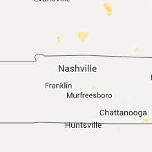


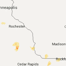


Cities Most Affected by Hail Storms of 6/14/2016
| Hail Size | Demographics of Zip Codes Affected | ||||||
|---|---|---|---|---|---|---|---|
| City | Count | Average | Largest | Pop Density | House Value | Income | Age |
| Newell, SD | 1 | 2.75 | 2.75 | 1 | $38k | $25.9k | 47.2 |
| Toccoa, GA | 1 | 1.75 | 1.75 | 139 | $79k | $29.3k | 40.4 |
| Camp Crook, SD | 1 | 1.75 | 1.75 | 0 | $44k | $25.5k | 41.5 |
| New Hampton, IA | 1 | 1.75 | 1.75 | 34 | $79k | $40.4k | 45.1 |
Hail and Wind Damage Spotted on 6/14/2016
Filter by Report Type:Hail ReportsWind Reports
States Impacted
Oklahoma, Illinois, Indiana, Georgia, Montana, South Carolina, Iowa, Minnesota, Kentucky, Tennessee, Nebraska, South Dakota, North Carolina, Florida, Texas, MissouriOklahoma
| Local Time | Report Details |
|---|---|
| 8:00 AM CDT | Storm damage reported in comanche county OK, 47 miles N of Wichita Falls, TX |
Illinois
| Local Time | Report Details |
|---|---|
| 11:50 AM CDT | Numerous trees and powerlines down throughout the county... too busy to give exact locations... but oregon hit har in ogle county IL, 73.4 miles S of Madison, WI |
| 11:55 AM CDT | Powerlines downed near alworth in winnebago county IL, 58 miles S of Madison, WI |
| 12:25 AM CDT | Large tree down blocking route 72 between kirkland and fairdale. time estimated based on radar in de kalb county IL, 64.3 miles WNW of Chicago, IL |
Indiana
| Local Time | Report Details |
|---|---|
| 2:15 PM EDT | Windows blown out of the walmart in corydo in harrison county IN, 28.5 miles NW of Louisville, KY |
| 3:40 PM EDT | Trees dow in washington county IN, 50.4 miles NNW of Louisville, KY |
| 3:48 PM EDT | Trees dow in dubois county IN, 52 miles ENE of Evansville, IN |
| 4:07 PM EDT | Some trees down...street flooding in lawrence county IN, 66.9 miles NW of Louisville, KY |
Georgia
| Local Time | Report Details |
|---|---|
| 2:15 PM EDT | Numerous trees down in south part of dalton. one on structure on liberty dr in madison county GA, 58.9 miles SW of Greenville, SC |
| 2:15 PM EDT | Numerous trees down in south part of dalton. one on structure on liberty dr in whitfield county GA, 27.8 miles SE of Chattanooga, TN |
| 2:16 PM EDT | Large trees down on gardi road in wayne county GA, 59.5 miles SW of Savannah, GA |
| 2:20 PM EDT | Large tree down at broadhurst rd and hwy 301 in wayne county GA, 55.5 miles E of Douglas, GA |
| 2:35 PM EDT | Quarter sized hail reported near Mcdonough, GA, 29.4 miles SE of Atlanta, GA, quarter size hail reported near ola |
| 2:45 PM EDT | Trained spotter reported large pine tree down on 500 block of prince roa in long county GA, 45.3 miles SW of Savannah, GA |
| 3:00 PM EDT | Warning point reported power lines down on the 300 block of east main stree in chatham county GA, 12.7 miles WNW of Savannah, GA |
| 3:00 PM EDT | Glynn county 911/dispatch reports multiple powerlines downed by strong wind gusts throughout the count in glynn county GA, 56.8 miles N of Jacksonville, FL |
| 3:00 PM EDT | Warning point reported tree down on highway 80 at cypress street. both lanes blocked. also tree down on house in the same are in chatham county GA, 12.2 miles WNW of Savannah, GA |
| 3:01 PM EDT | Warning point reported tree down at the intersection of cypress street and cregor street in chatham county GA, 12 miles WNW of Savannah, GA |
| 3:10 PM EDT | Quarter sized hail reported near Covington, GA, 30.6 miles ESE of Atlanta, GA, quarter size hail near heaton rd |
| 3:10 PM EDT | In addition to quarter size hail... 2 trees blown down in backyard along heaton rd in newton county GA, 30.1 miles ESE of Atlanta, GA |
| 3:35 PM EDT | Public reported large section of heavy wooden fence and trees down at the savannah mall. winds were estimated at 60 mp in chatham county GA, 8.4 miles SSW of Savannah, GA |
| 4:42 PM EDT | Golf Ball sized hail reported near Toccoa, GA, 36.6 miles WSW of Greenville, SC, spotter relayed report of golfball size hail on shorewood circle. |
| 4:42 PM EDT | Many power poles reported blown down on shorewood circl in stephens county GA, 36.6 miles WSW of Greenville, SC |
| 4:42 PM EDT | Many power poles reported blown down on shorewood circl in stephens county GA, 36.6 miles WSW of Greenville, SC |
| 5:25 PM EDT | 911 call center received report of 3 trees down...one at the board of education...one near the mountain lakes resort around alternate 75...and one at tractor supply. al in white county GA, 67 miles WSW of Greenville, SC |
| 5:58 PM EDT | Report of line down / power outag in lincoln county GA, 36.5 miles NW of Augusta, GA |
Montana
| Local Time | Report Details |
|---|---|
| 12:42 PM MDT | Storm damage reported in beaverhead county MT, 66 miles E of Salmon, ID |
| 4:32 PM MDT | Zortman raws site recorded a gust to 58 mp in phillips county MT, 68.5 miles SE of Havre, MT |
| 4:32 PM MDT | Measured 58mph at zortman blm raws statio in phillips county MT, 70 miles SE of Havre, MT |
| 4:41 PM MDT | Measured 72mph at manning corral dogtown raws statio in phillips county MT, 80.7 miles SE of Havre, MT |
| 5:00 PM MDT | Storm damage reported in phillips county MT, 69.5 miles ESE of Havre, MT |
| 5:00 PM MDT | Storm damage reported in phillips county MT, 69.5 miles ESE of Havre, MT |
| 5:15 PM MDT | Estimated 60mph wind gusts. heavy rai in phillips county MT, 58.3 miles W of Glasgow, MT |
| 5:18 PM MDT | Storm damage reported in blaine county MT, 47.1 miles ESE of Havre, MT |
| 5:58 PM MDT | Storm damage reported in phillips county MT, 59.2 miles NW of Glasgow, MT |
South Carolina
| Local Time | Report Details |
|---|---|
| 2:49 PM EDT | Trees in roadway carswell drive and bluff roa in richland county SC, 66.2 miles ENE of Augusta, GA |
| 2:55 PM EDT | Trees down bluff road and i-7 in richland county SC, 65.4 miles ENE of Augusta, GA |
| 3:26 PM EDT | Trees in roadway shumpert hill r in lexington county SC, 38.6 miles ENE of Augusta, GA |
| 3:40 PM EDT | Trees down fairview roa in richland county SC, 67 miles ENE of Augusta, GA |
| 4:30 PM EDT | Trees down hwy 601 at congaree rive in richland county SC, 53.6 miles NW of Charleston, SC |
| 4:57 PM EDT | 779 power outages reported in calhoun county in and around st matthew in calhoun county SC, 55.1 miles NW of Charleston, SC |
| 5:20 PM EDT | Downed power lines legrand and bepot street in chesterfield county SC, 64.6 miles SE of Charlotte, NC |
| 5:24 PM EDT | Downed trees and blown transformer on market stree in chesterfield county SC, 65.2 miles ESE of Charlotte, NC |
| 5:34 PM EDT | Report of tree down on new hopewell rd near bethlehem rd. time estimated by rada in darlington county SC, 74 miles SE of Charlotte, NC |
| 5:34 PM EDT | Report of tree down at the intersection of antioch rd and bethlehem rd. time estimated by rada in darlington county SC, 72.7 miles SE of Charlotte, NC |
| 6:12 PM EDT | Tree blown dow in greenville county SC, 15.8 miles ENE of Greenville, SC |
| 6:24 PM EDT | Tree down at 524 brendale d in chester county SC, 40.6 miles SSW of Charlotte, NC |
| 6:24 PM EDT | Tree down at beltline rd and hamilton r in chester county SC, 40.7 miles SSW of Charlotte, NC |
| 6:30 PM EDT | Tree down at tigerville rd and locust hill r in greenville county SC, 18.1 miles NE of Greenville, SC |
| 6:33 PM EDT | Powerlines blown down at hwy 290 and locust hill baptist churc in greenville county SC, 18.1 miles NE of Greenville, SC |
| 6:42 PM EDT | Tree down at hardin staigt rd and yor in chester county SC, 37.4 miles SSW of Charlotte, NC |
| 6:48 PM EDT | Several trees blown down on pleasant hill r in greenville county SC, 26.3 miles NE of Greenville, SC |
| 7:00 PM EDT | Tree down at 1313 mt lebanon r in spartanburg county SC, 28.6 miles ENE of Greenville, SC |
| 7:45 PM EDT | County official reported a swath of trees blown down from spartanburg to boiling springs...to chesne in spartanburg county SC, 47.4 miles ENE of Greenville, SC |
| 10:40 PM EDT | Tree down at the intersection of north sally hill rd and river bend driv in florence county SC, 66.7 miles N of Charleston, SC |
Iowa
| Local Time | Report Details |
|---|---|
| 2:24 PM CDT | Storm damage reported in dickinson county IA, 47.7 miles N of Storm Lake, IA |
| 2:30 PM CDT | Storm damage reported in clay county IA, 34.8 miles N of Storm Lake, IA |
| 2:30 PM CDT | Damage to a mobile hom in dickinson county IA, 56.3 miles N of Storm Lake, IA |
| 2:36 PM CDT | Several trees down in dickinson county IA, 49.3 miles N of Storm Lake, IA |
| 2:44 PM CDT | Widespread tree damage and power lines dow in dickinson county IA, 47.2 miles N of Storm Lake, IA |
| 2:50 PM CDT | Roof blown off mobile home and power lines dow in dickinson county IA, 53.5 miles N of Storm Lake, IA |
| 3:11 PM CDT | Gust 1 minute prior to 60 mph as wel in emmet county IA, 52.8 miles NNE of Storm Lake, IA |
| 3:30 PM CDT | A moderately-sized cattle shed was destroyed along with tree branches down around the homestead. a grain bin was blown a half-mile into a nearby field. another shed was in pocahontas county IA, 35.9 miles ENE of Storm Lake, IA |
| 3:36 PM CDT | Several large limbs down and trees split in half. diameter around 24 inches. in pocahontas county IA, 36.7 miles ENE of Storm Lake, IA |
| 3:45 PM CDT | Storm damage reported in kossuth county IA, 53 miles W of Mason City, IA |
| 3:49 PM CDT | Semi truck blown over near highways 52 and 13 from storm in clayton county IA, 56.2 miles S of La Crosse, WI |
| 4:13 PM CDT | Trees and powerlines damaged in town. report relayed by nws employee. time estimated by rada in bremer county IA, 39.6 miles ESE of Mason City, IA |
| 4:32 PM CDT | Golf Ball sized hail reported near New Hampton, IA, 40.5 miles E of Mason City, IA, reported along highway 18 |
| 4:35 PM CDT | Reported near highway 1 in chickasaw county IA, 39.5 miles E of Mason City, IA |
| 5:06 PM CDT | Four inch tree limbs broken in town. report via social medi in hancock county IA, 30.5 miles W of Mason City, IA |
| 5:50 PM CDT | Report of a large tree down in scranto in greene county IA, 54.7 miles SE of Storm Lake, IA |
| 5:58 PM CDT | Estimated 60 mph wind gust. no damage noted at this tim in greene county IA, 49.8 miles NW of Des Moines, IA |
| 6:32 PM CDT | Trees down in grand junctio in greene county IA, 44.3 miles NW of Des Moines, IA |
| 6:52 PM CDT | Large trees down in jefferson. skid steers out removing debri in greene county IA, 49.4 miles NW of Des Moines, IA |
| 6:55 PM CDT | Roof of cattle barn peeled off. in bremer county IA, 49.7 miles ESE of Mason City, IA |
| 7:07 PM CDT | Grain bin blown into large lp on west side of sumne in bremer county IA, 58.5 miles ESE of Mason City, IA |
| 7:38 PM CDT | Several trees down and a grain bin near 280th st and dugan ave...time estimated from rada in buchanan county IA, 31.3 miles NNW of Cedar Rapids, IA |
| 7:50 PM CDT | 6 inch diameter tree snapped off along with corn flattened in the vicinit in dallas county IA, 22.3 miles WNW of Des Moines, IA |
| 8:10 PM CDT | Sustained winds around 35 mph with peak gusts around 60 mph. no known damag in dallas county IA, 18.9 miles WNW of Des Moines, IA |
| 8:55 PM CDT | Large tree down in monticell in jones county IA, 30.8 miles NE of Cedar Rapids, IA |
Minnesota
| Local Time | Report Details |
|---|---|
| 2:35 PM CDT | Several large tree limbs down on southeast side of tow in nobles county MN, 57.1 miles E of Sioux Falls, SD |
| 2:41 PM CDT | Large tree limbs dow in nobles county MN, 64.6 miles E of Sioux Falls, SD |
| 2:45 PM CDT | 18 to 24 inch diameter tree snapped off above the groun in jackson county MN, 69.3 miles N of Storm Lake, IA |
| 2:46 PM CDT | Trees on power line in nobles county MN, 60.1 miles E of Sioux Falls, SD |
| 2:50 PM CDT | 2-3 inch in diameter tree limbs dow in jackson county MN, 71.3 miles N of Storm Lake, IA |
| 3:10 PM CDT | Several large trees dow in cottonwood county MN, 76.4 miles SSE of Montevideo, MN |
| 3:10 PM CDT | Small tree branches dow in cottonwood county MN, 79.4 miles SSE of Montevideo, MN |
| 3:10 PM CDT | Large tree blown over and corn laying fla in cottonwood county MN, 76.7 miles SSE of Montevideo, MN |
| 3:15 PM CDT | Few trees dow in watonwan county MN, 86.8 miles NNE of Storm Lake, IA |
| 3:20 PM CDT | Eight to nine inch diameter tree branches severed. occurred near 8th ave n. and 3rd st. north. in watonwan county MN, 86 miles SE of Montevideo, MN |
| 3:25 PM CDT | Few trees dow in watonwan county MN, 75.9 miles SE of Montevideo, MN |
| 4:00 PM CDT | Uprooted tree and many branches down. occurred at the cemeter in brown county MN, 74.9 miles SW of Minneapolis, MN |
| 4:20 PM CDT | Tree toppled onto hous in blue earth county MN, 69.4 miles SSW of Minneapolis, MN |
| 5:09 PM CDT | Fifteen inch diameter tree snapped off at the bas in blue earth county MN, 74.3 miles NW of Mason City, IA |
| 5:12 PM CDT | Few streets closed due to scattered trees over road in le sueur county MN, 54.5 miles SSW of Minneapolis, MN |
| 5:12 PM CDT | Tree down over power lin in le sueur county MN, 53.7 miles SSW of Minneapolis, MN |
Kentucky
| Local Time | Report Details |
|---|---|
| 4:50 PM EDT | Several trees down along cundiff hollow roa in bullitt county KY, 4.6 miles SSW of Louisville, KY |
| 5:11 PM EDT | Downed tree in central park crushed some bench seat in jefferson county KY, 16.9 miles N of Louisville, KY |
| 5:49 PM EDT | Downed tree blocking the road near the intersection of brownsboro and birchwoo in jefferson county KY, 18.8 miles N of Louisville, KY |
Tennessee
| Local Time | Report Details |
|---|---|
| 5:10 PM EDT | Multiple trees reported down in the city of loudon in loudon county TN, 29 miles WSW of Knoxville, TN |
| 5:45 PM EDT | Quarter sized hail reported near Maryville, TN, 10.6 miles SSE of Knoxville, TN |
| 6:22 PM EDT | A couple of trees reported down with large limbs broken off as wel in sevier county TN, 11.5 miles ESE of Knoxville, TN |
Nebraska
| Local Time | Report Details |
|---|---|
| 5:25 PM CDT | Ping Pong Ball sized hail reported near Ainsworth, NE, 41.7 miles ESE of Valentine, NE, hail mostly bb to pea size...some nearing golf ball but few and far between |
| 6:20 PM CDT | Half Dollar sized hail reported near Bassett, NE, 45.6 miles W of Oneill, NE |
South Dakota
| Local Time | Report Details |
|---|---|
| 4:35 PM MDT | Golf Ball sized hail reported near Camp Crook, SD, 100.6 miles ESE of Miles City, MT, hailed for 20-30 minutes. mostly dime-quarter size with a few as large as golf balls. 50-55 mph winds gusts. |
| 7:35 PM MDT | Baseball sized hail reported near Newell, SD, 54.6 miles N of Rapid City, SD, mostly pea to dime but some ping pong to baseball size hail. 40 mph wind gusts. |
North Carolina
| Local Time | Report Details |
|---|---|
| 6:43 PM EDT | Quarter sized hail reported near Wallace, NC, 34.3 miles N of Wilmington, NC, ham radio report relayed by wfo ilm |
| 6:45 PM EDT | Media received reports of a few trees down and quarter size hail near wallace. time estimated from rada in duplin county NC, 34.3 miles N of Wilmington, NC |
| 7:20 PM EDT | Reports of several trees blown down across the cit in union county NC, 23.3 miles SE of Charlotte, NC |
| 7:45 PM EDT | Quarter sized hail reported near Richlands, NC, 51.1 miles NNE of Wilmington, NC, quarter size hail reported in richlands near oaj airport |
| 7:50 PM EDT | Half Dollar sized hail reported near Richlands, NC, 51.1 miles NNE of Wilmington, NC, media relayed 1.25 inch report |
| 8:00 PM EDT | Multiple trees blown down across the cit in rutherford county NC, 51.4 miles NE of Greenville, SC |
| 8:05 PM EDT | Fire dept relayed a report of a tree blown down on kistler av in mecklenburg county NC, 4.1 miles ESE of Charlotte, NC |
| 8:15 PM EDT | Fire dept relayed a report of a tree blown down on kistler av in mecklenburg county NC, 4.1 miles ESE of Charlotte, NC |
| 8:42 PM EDT | Spotter reports trees down on house with person trapped inside.intersection of ankle and dirty ankle rd in burke county NC, 47 miles WNW of Charlotte, NC |
Florida
| Local Time | Report Details |
|---|---|
| 7:50 PM EDT | Quarter sized hail reported near Saint Cloud, FL, 21.2 miles SSE of Orlando, FL, quarter sized hail fell in saint cloud. pictures relayed from wftv via social media. |
Texas
| Local Time | Report Details |
|---|---|
| 7:37 PM CDT | Half Dollar sized hail reported near Paducah, TX, 39.7 miles S of Childress, TX |
Missouri
| Local Time | Report Details |
|---|---|
| 3:00 AM CDT | 3-4 inch diameter tree limbs down in st. clair county MO, 68.6 miles NNW of Springfield, MO |
| 3:05 AM CDT | Medium size tree limbs and power lines blown down in osceola in st. clair county MO, 62.2 miles NNW of Springfield, MO |
Connect with Interactive Hail Maps