

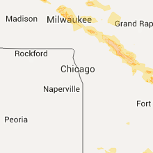
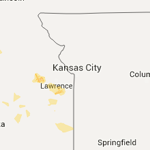
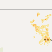
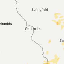
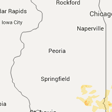
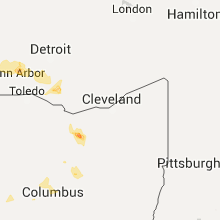
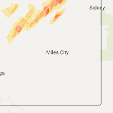
Hail Map for Wednesday, June 15, 2016

Number of Impacted Households on 6/15/2016
0
Impacted by 1" or Larger Hail
0
Impacted by 1.75" or Larger Hail
0
Impacted by 2.5" or Larger Hail
Square Miles of Populated Area Impacted on 6/15/2016
0
Impacted by 1" or Larger Hail
0
Impacted by 1.75" or Larger Hail
0
Impacted by 2.5" or Larger Hail


Cities Most Affected by Hail Storms of 6/15/2016
| Hail Size | Demographics of Zip Codes Affected | ||||||
|---|---|---|---|---|---|---|---|
| City | Count | Average | Largest | Pop Density | House Value | Income | Age |
| Clarendon, TX | 2 | 3.38 | 4.00 | 1 | $51k | $29.3k | 42.4 |
| Sedgwick, KS | 3 | 2.25 | 2.50 | 26 | $74k | $46.9k | 39.8 |
| Colwich, KS | 1 | 2.00 | 2.00 | 43 | $99k | $52.7k | 34.0 |
| Friendship, WI | 1 | 2.00 | 2.00 | 36 | $77k | $29.9k | 52.1 |
| Halstead, KS | 1 | 2.00 | 2.00 | 36 | $74k | $42.8k | 40.3 |
| Coloma, WI | 1 | 1.75 | 1.75 | 17 | $74k | $35.6k | 45.6 |
| Salina, KS | 1 | 1.75 | 1.75 | 216 | $86k | $37.0k | 37.3 |
| Silverton, TX | 1 | 1.75 | 1.75 | 1 | $31k | $30.3k | 46.2 |
| Fremont, WI | 1 | 1.75 | 1.75 | 48 | $111k | $46.3k | 47.2 |
| Batesville, AR | 1 | 1.75 | 1.75 | 83 | $67k | $31.6k | 38.7 |
| Necedah, WI | 1 | 1.75 | 1.75 | 26 | $78k | $33.2k | 44.8 |
Hail and Wind Damage Spotted on 6/15/2016
Filter by Report Type:Hail ReportsWind Reports
States Impacted
Indiana, North Carolina, Illinois, Kentucky, West Virginia, Missouri, Tennessee, South Carolina, Kansas, Wisconsin, Virginia, Texas, Ohio, New Mexico, Alabama, Arkansas, Florida, Georgia, Mississippi, Michigan, MontanaIndiana
| Local Time | Report Details |
|---|---|
| 12:35 PM EDT | Tree dow in orange county IN, 61.1 miles NW of Louisville, KY |
| 12:46 PM EDT | Tree dow in washington county IN, 54.4 miles NNW of Louisville, KY |
| 12:46 PM EDT | Trees down on powerlines on north sycamore street. the area is without powe in washington county IN, 55 miles NNW of Louisville, KY |
| 4:00 PM EDT | Four to eight large tree limbs down...including one on a house...on 71st street between binford boulevard and keystone avenue. time estimate in marion county IN, 7.2 miles NNE of Indianapolis, IN |
| 4:00 PM EDT | Four to eight large tree limbs down...including one on a house...on 71st street between binford boulevard and keystone avenue. time estimate in marion county IN, 7.2 miles NNE of Indianapolis, IN |
| 4:25 PM EDT | Trees down...minor damage to machine shed on farm. relayed by media. time estimate in daviess county IN, 63.5 miles NNE of Evansville, IN |
| 4:25 PM EDT | Trees and utility lines down around down. relayed by media. time estimate in daviess county IN, 67.2 miles NNE of Evansville, IN |
| 4:28 PM EDT | Measured with davis wind instrument...relayed by media in daviess county IN, 66.8 miles NNE of Evansville, IN |
| 4:28 PM EDT | Relayed by media in daviess county IN, 67.7 miles NNE of Evansville, IN |
| 4:35 PM EDT | Storm damage reported in hancock county IN, 14.5 miles ENE of Indianapolis, IN |
| 4:35 PM EDT | Multiple small to media tree limbs down in parking lot in marion county IN, 9.5 miles NNW of Indianapolis, IN |
| 4:54 PM EDT | Trees downed in butler tarkington are in marion county IN, 0.9 miles N of Indianapolis, IN |
| 5:00 PM EDT | Storm damage reported in marion county IN, 8.6 miles WNW of Indianapolis, IN |
| 5:03 PM EDT | Storm damage reported in marion county IN, 8.6 miles WNW of Indianapolis, IN |
| 5:05 PM EDT | Flooded road 63rd and college. fence blown dow in marion county IN, 0.9 miles N of Indianapolis, IN |
| 5:07 PM EDT | Quarter sized hail reported near Terre Haute, IN, 53.2 miles E of Mattoon, IL, mostly penny to nickel size hail but a few quarters were mixed in at crawford street and 13th street. |
| 5:07 PM EDT | Storm damage reported in marion county IN, 8.6 miles WNW of Indianapolis, IN |
| 5:11 PM EDT | Trees or tree limbs dow in rush county IN, 30.9 miles E of Indianapolis, IN |
| 5:12 PM EDT | Utility lines and trees or tree limbs down in rush county IN, 30.9 miles E of Indianapolis, IN |
| 5:18 PM EDT | Power out in parts of irvingto in marion county IN, 4.9 miles E of Indianapolis, IN |
| 5:18 PM EDT | 4-inch diameter tree limb down in henry county IN, 37.9 miles E of Indianapolis, IN |
| 5:55 PM EDT | One 10 to 12-inch diameter tree snapped off at base in marion county IN, 8.9 miles S of Indianapolis, IN |
| 6:07 PM EDT | Storm damage reported in knox county IN, 57.1 miles NNE of Evansville, IN |
| 6:15 PM EDT | Storm damage reported in greene county IN, 63.3 miles SW of Indianapolis, IN |
| 6:17 PM EDT | Two trees down...size unknow in knox county IN, 57.1 miles NNE of Evansville, IN |
| 6:25 PM EDT | Tree down in marion county IN, 9 miles NW of Indianapolis, IN |
| 6:42 PM EDT | Trees dow in dubois county IN, 49.9 miles NE of Evansville, IN |
| 6:48 PM EDT | Tree and power poll dow in dubois county IN, 44.8 miles NE of Evansville, IN |
| 6:50 PM EDT | Downed tree blocking the road near the intersection of east county road 300 north and north kellerville roa in dubois county IN, 47.3 miles NE of Evansville, IN |
| 7:08 PM EDT | Large limbs downe in ohio county IN, 23.2 miles WSW of Cincinnati, OH |
North Carolina
| Local Time | Report Details |
|---|---|
| 1:25 PM EDT | Two trees down on nine mile roa in carteret county NC, 72.8 miles ENE of Wilmington, NC |
| 3:00 PM EDT | Citn7 at cedar island ferry terminal recorded 52 kt wind gus in carteret county NC, 106.1 miles ENE of Wilmington, NC |
| 5:16 PM EDT | 1 tree down on duck pond road in linden in cumberland county NC, 40.1 miles SSW of Raleigh, NC |
| 6:12 PM EDT | One tree was reported down near the intersection of high pine church road and panther mountain roa in randolph county NC, 57.6 miles ENE of Charlotte, NC |
| 6:22 PM EDT | One tree was reported down across south walker avenue at south asheboro middle schoo in randolph county NC, 65.8 miles ENE of Charlotte, NC |
| 6:48 PM EDT | One tree was reported down near nc-highway 49 in ramseu in randolph county NC, 56.7 miles W of Raleigh, NC |
| 6:50 PM EDT | A couple of trees were reported down near the intersection of old staley road and shady grove church roa in randolph county NC, 52.7 miles W of Raleigh, NC |
| 8:08 PM EDT | 911 call center reports trees down along route 311 near the intersection with nc 174 in rockingham county NC, 53 miles SSE of Roanoke, VA |
Illinois
| Local Time | Report Details |
|---|---|
| 12:35 PM CDT | Late report- power lines and trees down near ina and southern portions of the county in jefferson county IL, 68.3 miles NNE of Cape Girardeau, MO |
| 2:30 PM CDT | Quarter sized hail reported near Arthur, IL, 15.4 miles NNW of Mattoon, IL, along county road 1900n |
| 3:02 PM CDT | Power lines dow in coles county IL, 0.8 miles W of Mattoon, IL |
| 3:02 PM CDT | Empty semi trailers blown over. numerous trees and power lines dow in coles county IL, 1.8 miles NW of Mattoon, IL |
| 3:11 PM CDT | Storm damage reported in coles county IL, 5.1 miles E of Mattoon, IL |
| 3:37 PM CDT | Quarter sized hail reported near Marshall, IL, 30.8 miles E of Mattoon, IL |
| 3:46 PM CDT | Powerlines down in clark county IL, 22.3 miles ESE of Mattoon, IL |
| 3:50 PM CDT | Trees down in clark county IL, 25.3 miles ESE of Mattoon, IL |
| 3:56 PM CDT | Power lines down on house in clark county IL, 28.3 miles ESE of Mattoon, IL |
| 3:58 PM CDT | Powerlines down in clark county IL, 37.1 miles E of Mattoon, IL |
| 4:06 PM CDT | Tree down in jasper county IL, 31.4 miles SE of Mattoon, IL |
| 4:11 PM CDT | Tree down in jasper county IL, 35.4 miles SSE of Mattoon, IL |
| 4:11 PM CDT | Storm damage reported in crawford county IL, 37.6 miles SE of Mattoon, IL |
| 4:15 PM CDT | Multiple power poles snapped. time estimate in crawford county IL, 43.2 miles ESE of Mattoon, IL |
| 4:15 PM CDT | Power lines down in jasper county IL, 38.3 miles SSE of Mattoon, IL |
| 4:17 PM CDT | Route 33 between willow hill and oblong closed due to power poles down. from idot district in jasper county IL, 39.7 miles SSE of Mattoon, IL |
| 4:17 PM CDT | Tress down in crawford county IL, 46.1 miles ESE of Mattoon, IL |
Kentucky
| Local Time | Report Details |
|---|---|
| 1:23 PM CDT | Trees snapped and uprooted along hwy 62 in 3 locations. fire rescue and law enforcement are respondin in mccracken county KY, 45.9 miles ESE of Cape Girardeau, MO |
| 1:35 PM CDT | *** 1 fatal *** delayed report. deputy sheriff reported that a tree fell onto the cab of a truck...killing the drive in graves county KY, 50.1 miles N of Mc Kenzie, TN |
| 1:45 PM CDT | Several trees down on west side of county. also a large tree limb down on east side of owensbor in daviess county KY, 24.3 miles SE of Evansville, IN |
| 2:45 PM EDT | Trees down. minor roof damage. power lines down as well. time estimate in jefferson county KY, 17.9 miles NE of Louisville, KY |
| 1:50 PM CDT | Late report. trees down along hwy 13 in henderson county KY, 12.2 miles S of Evansville, IN |
| 1:59 PM CDT | Em reports numerous trees down along roadways. heavy rain and strong winds reported with storm in marshall county KY, 50.2 miles N of Mc Kenzie, TN |
| 2:00 PM CDT | 3 foot diameter tree snappe in marshall county KY, 51.5 miles NNE of Mc Kenzie, TN |
| 2:00 PM CDT | Late report. trees down along hwy 641 just south of benton and along oak level road near the marshall/graves county lin in marshall county KY, 50.2 miles N of Mc Kenzie, TN |
| 2:05 PM CDT | Tree down at intersection of 4th and oliv in calloway county KY, 34.7 miles NNE of Mc Kenzie, TN |
| 2:10 PM CDT | Wind estimated. pea size hail reported with this stor in calloway county KY, 34.7 miles NNE of Mc Kenzie, TN |
| 3:10 PM EDT | Downed tree blocking manslick roa in jefferson county KY, 10 miles NNE of Louisville, KY |
| 2:15 PM CDT | Late report. numerous trees down. corn laid over. one tree fell across a home but no injuries reported. most damage reported along sarten road and hwy 51 sout in hickman county KY, 45.4 miles NW of Mc Kenzie, TN |
| 2:15 PM CDT | Trees down and snapped along the fort leasure trai in marshall county KY, 51.4 miles NNE of Mc Kenzie, TN |
| 2:35 PM CDT | Tree down along linton road. lost all of the traffic barrels on the new barkley bridge projec in trigg county KY, 55.6 miles NE of Mc Kenzie, TN |
| 2:39 PM CDT | Several trees down on highway 69 and at hoopie hill roa in ohio county KY, 52.1 miles ESE of Evansville, IN |
| 2:45 PM CDT | Tree down along south roa in trigg county KY, 62.4 miles NE of Mc Kenzie, TN |
| 2:45 PM CDT | Late report - tree down in drakesboro in muhlenberg county KY, 59.3 miles SSE of Evansville, IN |
| 2:45 PM CDT | Several trees down around the fulton area along hwy 307 and also near the purchase parkwa in fulton county KY, 32.9 miles NW of Mc Kenzie, TN |
| 2:46 PM CDT | Trees dow in ohio county KY, 53 miles SE of Evansville, IN |
| 2:50 PM CDT | Late report - power lines down near greenville in muhlenberg county KY, 56.9 miles SSE of Evansville, IN |
| 2:55 PM CDT | Winds estimated in christian county KY, 68.2 miles NW of Nashville, TN |
| 3:07 PM CDT | Several trees down in morgantow in butler county KY, 70.5 miles SE of Evansville, IN |
| 3:14 PM CDT | Tree down across roa in butler county KY, 66.2 miles SW of Louisville, KY |
| 3:15 PM CDT | Trees down in pembroke and hopkinsville. power outages reported in both communitie in christian county KY, 52.7 miles NW of Nashville, TN |
| 3:20 PM CDT | Power outages reported throughout the community in christian county KY, 50.2 miles NW of Nashville, TN |
| 3:25 PM CDT | Tree dow in logan county KY, 48.2 miles N of Nashville, TN |
| 3:28 PM CDT | Downed tree on a ca in logan county KY, 46.8 miles N of Nashville, TN |
| 3:38 PM CDT | Downed power lines blocking audubon driv in warren county KY, 58.8 miles NNE of Nashville, TN |
| 4:40 PM EDT | Tree dow in bullitt county KY, 2.5 miles WNW of Louisville, KY |
| 3:48 PM CDT | Tree down on henry clay smith r in simpson county KY, 39.6 miles NNE of Nashville, TN |
| 3:54 PM CDT | Trees and power lines down at sportsman lake road and at akin avenu in simpson county KY, 40.3 miles NNE of Nashville, TN |
| 6:34 PM EDT | 6 to 10 inch branches were torn from several trees on the south side of tow in kenton county KY, 1.9 miles S of Cincinnati, OH |
| 7:20 PM EDT | Large tree branch down. time estimated by rada in kenton county KY, 3.2 miles SW of Cincinnati, OH |
| 7:34 PM EDT | Storm damage reported in grant county KY, 22.7 miles SSW of Cincinnati, OH |
| 7:56 PM EDT | Trees downe in campbell county KY, 3.5 miles ESE of Cincinnati, OH |
| 8:29 PM EDT | Downed tree on a house at 104 first street and a tree blocking the roa in harrison county KY, 50.7 miles SSE of Cincinnati, OH |
| 9:05 PM EDT | Several power lines down across the count in clark county KY, 23.8 miles NNW of Irvine, KY |
| 9:08 PM EDT | Several downed trees across clark county blocking road in clark county KY, 23.5 miles NNW of Irvine, KY |
| 9:32 PM EDT | Tree down blocking stoney run rd. at phelps rd. time estimated based on rada in madison county KY, 17.8 miles NW of Irvine, KY |
| 9:43 PM EDT | 30 to 40 ft. tree down in powell county KY, 13.1 miles NE of Irvine, KY |
West Virginia
| Local Time | Report Details |
|---|---|
| 2:24 PM EDT | Tree down on cr54 in midkiff in lincoln county WV, 31.7 miles WSW of Charleston, WV |
| 2:30 PM EDT | Power lines down on sand creek road in lincoln county WV, 33 miles SW of Charleston, WV |
| 4:06 PM EDT | Tree down on granderson street in lester in raleigh county WV, 46 miles SSE of Charleston, WV |
Missouri
| Local Time | Report Details |
|---|---|
| 2:40 PM CDT | Severe thunderstorm wind gusts downed a large tree onto a mail box near lone pine resor in ozark county MO, 57.1 miles SE of Springfield, MO |
Tennessee
| Local Time | Report Details |
|---|---|
| 2:45 PM CDT | Also starting to get reports of power outage in stewart county TN, 44.9 miles ENE of Mc Kenzie, TN |
| 3:21 PM CDT | Image of a large tree limb down in the st. bethlehem area in montgomery county TN, 41.8 miles NW of Nashville, TN |
| 3:22 PM CDT | Widespread trees and power lines down across montgomery county with up to 4000 residents without powe in montgomery county TN, 41.8 miles NW of Nashville, TN |
| 3:23 PM CDT | Quarter sized hail reported near Troy, TN, 47.6 miles WNW of Mc Kenzie, TN, spotter on twiiter sent picture of quarter sized hail near samburg. |
| 3:35 PM CDT | Trees down on houses and cars at hwy 431 and capps road. time approximat in weakley county TN, 25.1 miles NW of Mc Kenzie, TN |
| 3:37 PM CDT | Image of a large tree limb downed in cumberland county TN, 64.7 miles N of Chattanooga, TN |
| 3:37 PM CDT | Image of a large tree limb downed in pleasant view in cheatham county TN, 21.3 miles NW of Nashville, TN |
| 3:39 PM CDT | Trees down on fykes grove road in robertson county TN, 27.2 miles NNW of Nashville, TN |
| 3:40 PM CDT | Trees down on highway 161 between highway 25 and highway 431 in robertson county TN, 29.4 miles NNW of Nashville, TN |
| 3:45 PM CDT | 67 mph gust measured with home equipment. time estimated based on rada in robertson county TN, 23.6 miles NNW of Nashville, TN |
| 3:45 PM CDT | Dickson herald reported scattered trees and power lines down across dickson county including a tree and power line down in burns at church and main streets. 900 custome in dickson county TN, 30.8 miles WSW of Nashville, TN |
| 3:50 PM CDT | Several trees and powerlines down throughout the county in robertson county TN, 23.6 miles NNW of Nashville, TN |
| 3:52 PM CDT | Trees down all over the ken-tenn hwy in union city and west hwy 22 and shawtown rd in obion county TN, 35.6 miles NW of Mc Kenzie, TN |
| 3:55 PM CDT | *** 1 inj *** a 3-story scaffold collapsed at a water tower construction site on morrow road. report indicates victim fell 70 fee in davidson county TN, 4.6 miles W of Nashville, TN |
| 3:55 PM CDT | Tree down on a house in sumner county TN, 32.5 miles NNE of Nashville, TN |
| 4:00 PM CDT | Damage to an awning at vanderbilt university in davidson county TN, 3 miles SW of Nashville, TN |
| 4:00 PM CDT | Tree down on rosa parks blvd near mainstream drive in davidson county TN, 2.8 miles WNW of Nashville, TN |
| 4:00 PM CDT | Tree limbs knocked down power lines which caused a fire at the nashville community cares rehab facility on hospital road in davidson county TN, 4.1 miles WNW of Nashville, TN |
| 4:00 PM CDT | 3 foot diamter tree blown down at centerville golf course... about 3 miles north of centerville. spotter also reported other trees blown down in the count in hickman county TN, 43.9 miles WSW of Nashville, TN |
| 4:02 PM CDT | Tree fell onto a house at 1327 pierce road in madison knocking down power lines and trapping a woman inside. no injurie in davidson county TN, 8.6 miles NNE of Nashville, TN |
| 4:02 PM CDT | Reports of tree limbs and trees down in the green hills area in davidson county TN, 6.1 miles SW of Nashville, TN |
| 4:03 PM CDT | Multiple trees down on cypress creek road in weakley county TN, 28.6 miles NW of Mc Kenzie, TN |
| 4:05 PM CDT | Up to 18000 power outages reported across nes service area including opry mills mall and green hills mall. nashville fire department responded to 62 calls of downed tre in davidson county TN, 0.2 miles NNW of Nashville, TN |
| 4:05 PM CDT | Video shows a tree falling onto a building in east nashville in davidson county TN, 1.6 miles E of Nashville, TN |
| 4:06 PM CDT | Small to medium size tree blown down in davidson county TN, 7.4 miles NNE of Nashville, TN |
| 4:08 PM CDT | Tree down across power line in benton county TN, 26.8 miles E of Mc Kenzie, TN |
| 4:09 PM CDT | 5 inch diameter tree limb downed in davidson county TN, 12 miles NNE of Nashville, TN |
| 4:09 PM CDT | Image of a large tree downed in davidson county TN, 4.7 miles S of Nashville, TN |
| 4:10 PM CDT | Numerous trees down in crieve hall area with some on roads in davidson county TN, 6.8 miles S of Nashville, TN |
| 4:11 PM CDT | Trees and power lines down between camden and eva. time approximate in benton county TN, 23.5 miles E of Mc Kenzie, TN |
| 4:12 PM CDT | Large tree down in donelson in davidson county TN, 6.6 miles E of Nashville, TN |
| 4:13 PM CDT | Numerous trees and limbs down in brandywine subdivision in davidson county TN, 10.3 miles ENE of Nashville, TN |
| 4:13 PM CDT | Image and several reports of tree limbs snapped in hendersonville in sumner county TN, 13.1 miles NE of Nashville, TN |
| 4:14 PM CDT | Image of a tree down at metro center in davidson county TN, 2.2 miles N of Nashville, TN |
| 4:14 PM CDT | Tree down on a house in tulip grove area of hermitage in davidson county TN, 10.4 miles ENE of Nashville, TN |
| 4:14 PM CDT | Several trees down in devonshire road area in wilson county TN, 12 miles ENE of Nashville, TN |
| 4:15 PM CDT | Tspotter report of several large trees down on grandview drive near lebanon road in mount juliet in wilson county TN, 12.2 miles ENE of Nashville, TN |
| 4:15 PM CDT | Image of a one-foot diameter tree downed in davidson county TN, 9.1 miles ENE of Nashville, TN |
| 4:15 PM CDT | A tree was split along big horn drive. numerous branches were blown down along saundersville road and a flagpole was bent on matterhorn driv in wilson county TN, 12.4 miles ENE of Nashville, TN |
| 4:17 PM CDT | Tree down on south greenhill road partially blocking the road in wilson county TN, 14.7 miles ENE of Nashville, TN |
| 4:17 PM CDT | Gallatin news reported numerous trees down across gallatin with one falling onto a truck on perrolee st in sumner county TN, 24.3 miles NE of Nashville, TN |
| 4:18 PM CDT | Image of a large tree limb snapped in sumner county TN, 23.5 miles NE of Nashville, TN |
| 4:18 PM CDT | Large maple tree down at woodlawn drive in wilson county TN, 13.5 miles ENE of Nashville, TN |
| 4:19 PM CDT | Large tree down near granbury elementary school. tree also downed power line in williamson county TN, 11 miles S of Nashville, TN |
| 4:21 PM CDT | Report of roof damage in williamson county TN, 16.5 miles S of Nashville, TN |
| 4:21 PM CDT | Trees down in the deshea creek area northeast of gallatin in sumner county TN, 28.7 miles NE of Nashville, TN |
| 4:23 PM CDT | Tree down on a house 2 miles east of highway 231/highway 25 intersection in trousdale county TN, 34.5 miles ENE of Nashville, TN |
| 4:25 PM CDT | Several small trees down and minor roof damage to a home in macon county TN, 48.3 miles ENE of Nashville, TN |
| 4:25 PM CDT | Tree down on house and power lines down on royal oaks drive in north mount juliet in wilson county TN, 15.6 miles ENE of Nashville, TN |
| 4:25 PM CDT | Trees blocking roadway on divider...natchez trace...stigall road and highway 70 and flatwood roads west of camde in benton county TN, 22.9 miles ESE of Mc Kenzie, TN |
| 4:25 PM CDT | A tree was blown down across central pike near pleasant grove rd and traffic was blocke in wilson county TN, 12.9 miles E of Nashville, TN |
| 4:25 PM CDT | Tree blocking the road at 3000 west division street in wilson county TN, 12.5 miles ENE of Nashville, TN |
| 4:28 PM CDT | Image of a large tree down in wilson county TN, 12.2 miles E of Nashville, TN |
| 4:29 PM CDT | Tree fell on a car in wilson county TN, 25.8 miles E of Nashville, TN |
| 4:29 PM CDT | Tree fell on a car at 11573 lebanon road in wilson county TN, 22.1 miles ENE of Nashville, TN |
| 4:30 PM CDT | City animal control building was damaged. extent unknow in wilson county TN, 25.8 miles E of Nashville, TN |
| 4:30 PM CDT | Several reports of trees down in smyrna in rutherford county TN, 19.4 miles SE of Nashville, TN |
| 4:30 PM CDT | Tree downed blocking weakly lane in rutherford county TN, 20.7 miles ESE of Nashville, TN |
| 4:30 PM CDT | Damage to sam houston elementary school in wilson county TN, 26.1 miles E of Nashville, TN |
| 4:31 PM CDT | Roof was blown off new city animal control building on sparta pike in wilson county TN, 27.9 miles E of Nashville, TN |
| 4:32 PM CDT | Image of a tree downed in lebanon in wilson county TN, 25.8 miles E of Nashville, TN |
| 4:37 PM CDT | A large grain bin was toppled over. time estimated based on radar in smith county TN, 41.2 miles ENE of Nashville, TN |
| 4:37 PM CDT | Tree fell onto vine baptist church at 9050 murfreesboro road in wilson county TN, 25.5 miles ESE of Nashville, TN |
| 4:40 PM CDT | Several reports of trees and power lines down throughout the county in wilson county TN, 14.7 miles ENE of Nashville, TN |
| 4:45 PM CDT | Trees and power lines down in wilson county TN, 36 miles E of Nashville, TN |
| 4:45 PM CDT | Tree fell and damaged roof and side of a house in murfreesboro in rutherford county TN, 30.9 miles SE of Nashville, TN |
| 4:48 PM CDT | Detached carport flipped and destroyed in smith county TN, 47.3 miles E of Nashville, TN |
| 4:50 PM CDT | Many trees reported down in obion count in obion county TN, 35.6 miles NW of Mc Kenzie, TN |
| 4:50 PM CDT | A few trees blown down in columbia in maury county TN, 40.7 miles SSW of Nashville, TN |
| 4:53 PM CDT | Numerous reports of trees and power lines down countywide in rutherford county TN, 30.9 miles SE of Nashville, TN |
| 4:55 PM CDT | 40-50 foot tall and 4-foot diameter tree uprooted in wilson county TN, 25.4 miles ENE of Nashville, TN |
| 4:55 PM CDT | Tree down in mount pleasant in maury county TN, 48.5 miles SSW of Nashville, TN |
| 4:56 PM CDT | Image of a large tree down in elmwood in smith county TN, 50.4 miles E of Nashville, TN |
| 5:02 PM CDT | Chicken coop blown apart and two trees also down at the house across the street in rutherford county TN, 37.8 miles SE of Nashville, TN |
| 5:13 PM CDT | Numerous trees and limbs down in brandywine subdivision in davidson county TN, 10.3 miles ENE of Nashville, TN |
| 5:13 PM CDT | Trees downed and street signs blown over in de kalb county TN, 55.5 miles ESE of Nashville, TN |
| 5:15 PM CDT | Multiple reports of trees and power lines down throughout the county in cannon county TN, 46.4 miles ESE of Nashville, TN |
| 5:18 PM CDT | Tspotter report of a tree down near baxter in putnam county TN, 63.1 miles E of Nashville, TN |
| 5:23 PM CDT | A few trees down throughout the county in marshall county TN, 49.5 miles S of Nashville, TN |
| 5:30 PM CDT | Trees were blown down with power outages. a 60 mph wind gust was measure in giles county TN, 45.8 miles NE of Florence, AL |
| 5:31 PM CDT | Tree down on lyndell bell road blocking one lane of traffic in coffee county TN, 57.5 miles WNW of Chattanooga, TN |
| 5:35 PM CDT | Tree down in yard of home near center of town in coffee county TN, 52.4 miles NW of Chattanooga, TN |
| 5:35 PM CDT | Tspotter report of tree down on ingram street in manchester in coffee county TN, 52.9 miles NW of Chattanooga, TN |
| 5:37 PM CDT | Several trees and power lines down in warren county TN, 51.7 miles NNW of Chattanooga, TN |
| 5:39 PM CDT | A few trees down throughout the county in giles county TN, 45.8 miles NE of Florence, AL |
| 5:40 PM CDT | Numerous trees down across the county in bedford county TN, 50.2 miles SSE of Nashville, TN |
| 5:40 PM CDT | A large oak tree was blown down onto a house on union hill rd. time is estimate in lawrence county TN, 26.7 miles NE of Florence, AL |
| 5:42 PM CDT | Ema reports multiple trees down in lynchbur in moore county TN, 61.6 miles WNW of Chattanooga, TN |
| 5:43 PM CDT | Several trees...power lines...and telephone wires down throughout the county in white county TN, 61.6 miles N of Chattanooga, TN |
| 5:45 PM CDT | Dozens of trees were knocked down throughout the county. several telephone poles and power lines also knocked down. power outages near the tims ford lake are in franklin county TN, 56.2 miles WNW of Chattanooga, TN |
| 5:45 PM CDT | Trees reported down on paint hollow roa in lincoln county TN, 65.4 miles SSE of Nashville, TN |
| 5:45 PM CDT | Tspotter report of a tree and power line down near east lincoln elementary school in tullahoma in coffee county TN, 55.1 miles WNW of Chattanooga, TN |
| 5:56 PM CDT | Several trees down throughout the county are blocking roadways. a few power lines were also downe in van buren county TN, 48.6 miles N of Chattanooga, TN |
| 5:57 PM CDT | Trees reported down on bellview roa in lincoln county TN, 62.3 miles ENE of Florence, AL |
| 5:57 PM CDT | Trees reported down on roa in lincoln county TN, 66.1 miles ENE of Florence, AL |
| 6:05 PM CDT | Trees down 2 inch diameter...estimated wind gusts 60 mph in lincoln county TN, 65.6 miles ENE of Florence, AL |
| 6:05 PM CDT | Trees were reported down on molino and cold springs road in lincoln county TN, 57.5 miles ENE of Florence, AL |
| 6:05 PM CDT | Trees down on blanche roa in lincoln county TN, 55.2 miles ENE of Florence, AL |
| 6:05 PM CDT | A car port was blown onto u.s. highway 64 near huntland. time estimated by rada in franklin county TN, 54.5 miles W of Chattanooga, TN |
| 6:05 PM CDT | Report via twitter of trees and power lines down in the kirkland and bellview area in lincoln county t in lincoln county TN, 61.6 miles ENE of Florence, AL |
| 6:07 PM CDT | Tons of trees down throughout the county in grundy county TN, 35.6 miles NW of Chattanooga, TN |
| 6:15 PM CDT | Trees reported down on ellis childress roa in lincoln county TN, 66.6 miles ENE of Florence, AL |
| 6:15 PM CDT | Trees were reported down on smith mill roa in lincoln county TN, 66.9 miles ENE of Florence, AL |
| 6:28 PM CDT | Several trees down near dunla in sequatchie county TN, 22.8 miles NNW of Chattanooga, TN |
| 6:39 PM CDT | A few trees down throughout the county in giles county TN, 45.8 miles NE of Florence, AL |
| 7:48 PM EDT | Several trees down across signal mountai in hamilton county TN, 6 miles NNW of Chattanooga, TN |
| 8:15 PM CDT | Trees down in shelby county TN, 15.2 miles ESE of Memphis, TN |
South Carolina
| Local Time | Report Details |
|---|---|
| 4:35 PM EDT | Report of tree down at intersection of treadway rd and sc hwy 9. time estimated by rada in marion county SC, 63.9 miles NNE of Charleston, SC |
| 5:15 PM EDT | Report of tree down blocking roadway on sc hwy 66 between sc hwy 366 and sc hwy 905. time estimated by rada in horry county SC, 58.6 miles WSW of Wilmington, NC |
| 5:35 PM EDT | Very large sign at mellow mushroom restaurant on hwy 17 in n myrtle beach blown over onto parked vehicle. no injuries. time estimated by rada in horry county SC, 49.7 miles WSW of Wilmington, NC |
Kansas
| Local Time | Report Details |
|---|---|
| 4:10 PM CDT | Quarter sized hail reported near Tipton, KS, 47.4 miles ENE of Hays, KS |
| 4:39 PM CDT | Storm damage reported in reno county KS, 39.4 miles NW of Wichita, KS |
| 4:42 PM CDT | Quarter sized hail reported near Wichita, KS, 0.3 miles NW of Wichita, KS, public report via twitter of dime to quarter sized hail at lincoln and broadway. |
| 4:53 PM CDT | Quarter sized hail reported near Wichita, KS, 0.3 miles NW of Wichita, KS, viewer report to kwch of nickel to quarter sized hail in riverside. |
| 5:01 PM CDT | Quarter sized hail reported near Halstead, KS, 23.6 miles NNW of Wichita, KS, public report via picture on twitter of quarter or slightly larger sized hail. |
| 5:09 PM CDT | Ping Pong Ball sized hail reported near Halstead, KS, 23.6 miles NNW of Wichita, KS, picture sent via twitter of ping pong ball sized hail. |
| 5:09 PM CDT | Hen Egg sized hail reported near Halstead, KS, 23.6 miles NNW of Wichita, KS, twitter picture of two inch sized hail. time is based on other reports and radar. |
| 5:12 PM CDT | Quarter sized hail reported near Valley Center, KS, 10.7 miles N of Wichita, KS, twitter report of pea to quarter sized hail. |
| 5:18 PM CDT | Quarter sized hail reported near Valley Center, KS, 10.7 miles N of Wichita, KS, kwch tweeted a picture of quarter sized hail. |
| 5:30 PM CDT | Tennis Ball sized hail reported near Sedgwick, KS, 17.3 miles NW of Wichita, KS, picture report via facebook of tennis ball sized hail. time estimated from radar. |
| 5:34 PM CDT | Quarter sized hail reported near Whitewater, KS, 20.7 miles NNE of Wichita, KS |
| 5:34 PM CDT | Quarter sized hail reported near Whitewater, KS, 21.4 miles NNE of Wichita, KS |
| 5:35 PM CDT | Golf Ball sized hail reported near Sedgwick, KS, 17.3 miles NW of Wichita, KS, twitter picture sent of golf ball sized hail. |
| 5:40 PM CDT | Quarter sized hail reported near Sedgwick, KS, 16.9 miles NNW of Wichita, KS |
| 5:42 PM CDT | Tennis Ball sized hail reported near Sedgwick, KS, 16.9 miles NNW of Wichita, KS, facebook picture of 2.5 inch sized hail. time is based on radar. |
| 5:43 PM CDT | Quarter sized hail reported near Sedgwick, KS, 15.6 miles NNW of Wichita, KS, trained spotter estimates quarter sized hail and said it has been hailing for 15 minutes. |
| 5:59 PM CDT | Quarter sized hail reported near Halstead, KS, 24.8 miles NNW of Wichita, KS |
| 5:59 PM CDT | Trained spotter reports 71 mph winds and pea to quarter sized hai in harvey county KS, 24.8 miles NNW of Wichita, KS |
| 6:07 PM CDT | Golf Ball sized hail reported near Salina, KS, 61.8 miles WSW of Manhattan, KS, law enforcement reporting golf ball sized hail near interstate 135 and old highway 40. |
| 6:16 PM CDT | Quarter sized hail reported near Garden Plain, KS, 19 miles W of Wichita, KS, twitter report of nickel to quarter sized hail. |
| 6:25 PM CDT | Hen Egg sized hail reported near Colwich, KS, 12.9 miles WNW of Wichita, KS, twitter picture of two inch sized hail. |
| 6:26 PM CDT | Quarter sized hail reported near Inman, KS, 43.8 miles NW of Wichita, KS, observer reports nickel to quarter sized hail. |
| 6:45 PM CDT | Storm damage reported in saline county KS, 65.7 miles WSW of Manhattan, KS |
| 6:45 PM CDT | Power line and pole blown dow in dickinson county KS, 35.7 miles WSW of Manhattan, KS |
| 7:01 PM CDT | Emergency manager reports power poles are down near new cambri in saline county KS, 55.8 miles WSW of Manhattan, KS |
| 7:01 PM CDT | Storm damage reported in mcpherson county KS, 50.3 miles NNW of Wichita, KS |
| 7:01 PM CDT | Quarter sized hail reported near Wichita, KS, 6.8 miles W of Wichita, KS, nws employee reports quarter sized hail which has lasted for the last 2 minutes at 21st and 119th. |
| 7:06 PM CDT | Quarter sized hail reported near Mcpherson, KS, 49.7 miles NNW of Wichita, KS |
| 7:59 PM CDT | Storm damage reported in rice county KS, 68.3 miles ESE of Hays, KS |
| 8:14 PM CDT | Quarter sized hail reported near Valley Center, KS, 10.7 miles N of Wichita, KS, twitter report of quarter sized hail. |
| 8:14 PM CDT | Quarter sized hail reported near Sedgwick, KS, 15.6 miles NNW of Wichita, KS, twitter report of quarter sized hail. |
| 8:24 PM CDT | Quarter sized hail reported near Valley Center, KS, 10.7 miles N of Wichita, KS, picture sent via twitter of quarter sized hail. |
| 8:42 PM CDT | Storm damage reported in shawnee county KS, 42.6 miles ESE of Manhattan, KS |
| 8:48 PM CDT | Quarter sized hail reported near Topeka, KS, 45 miles ESE of Manhattan, KS, mainly nickel size hail but a few quarters. |
| 8:50 PM CDT | Quarter sized hail reported near Topeka, KS, 48.2 miles E of Manhattan, KS, i 470 and gage blvd. gusts estimated at 40 mph |
| 8:52 PM CDT | Large tree down on topeka boulevard near sw 27th street. radar estimated tim in shawnee county KS, 48.2 miles E of Manhattan, KS |
| 8:55 PM CDT | Half Dollar sized hail reported near Topeka, KS, 48.2 miles E of Manhattan, KS, photo taken from social media. radar estimated time. |
| 9:00 PM CDT | Quarter sized hail reported near Sedgwick, KS, 15.6 miles NNW of Wichita, KS, twitter report of quarter sized hail. |
| 9:26 PM CDT | Quarter sized hail reported near Mount Hope, KS, 21.8 miles NW of Wichita, KS |
| 9:33 PM CDT | Storm damage reported in sedgwick county KS, 7.7 miles NE of Wichita, KS |
| 9:45 PM CDT | Retired nws employee reports 60 mph wind in sedgwick county KS, 6.7 miles NNW of Wichita, KS |
| 10:02 PM CDT | Half Dollar sized hail reported near Valley Center, KS, 10.7 miles N of Wichita, KS, twitter picture of half dollar sized hail. |
| 10:25 PM CDT | Kake meteorologist reports a 60 mph wind gus in butler county KS, 14.3 miles ENE of Wichita, KS |
| 1:15 AM CDT | Missing shingles and damage to a deck at a home in bourbon county KS, 41.5 miles E of Chanute, KS |
Wisconsin
| Local Time | Report Details |
|---|---|
| 4:35 PM CDT | Golf Ball sized hail reported near Necedah, WI, 65.3 miles ENE of La Crosse, WI, time estimated from radar. |
| 4:36 PM CDT | Quarter sized hail reported near Necedah, WI, 67.3 miles ENE of La Crosse, WI, quarter sized hail and getting larger. |
| 4:45 PM CDT | Power lines dow in adams county WI, 68.3 miles ENE of La Crosse, WI |
| 4:45 PM CDT | Quarter sized hail reported near Arkdale, WI, 68.3 miles ENE of La Crosse, WI, . |
| 4:54 PM CDT | 3 to 5 inch diameter branches snapped of in adams county WI, 69 miles ENE of La Crosse, WI |
| 4:58 PM CDT | Several trees down near petenwell lak in adams county WI, 73.9 miles ENE of La Crosse, WI |
| 4:59 PM CDT | Quarter sized hail reported near Arkdale, WI, 74.7 miles NNW of Madison, WI, . |
| 5:05 PM CDT | Hen Egg sized hail reported near Friendship, WI, 71.2 miles NNW of Madison, WI, hail size estimated... but observer stated it was likely larger. |
| 5:08 PM CDT | Half Dollar sized hail reported near Friendship, WI, 68.9 miles NNW of Madison, WI, . |
| 5:19 PM CDT | A couple trees dow in oneida county WI, 15.6 miles E of Rhinelander, WI |
| 5:25 PM CDT | Golf Ball sized hail reported near Coloma, WI, 64.5 miles N of Madison, WI |
| 5:28 PM CDT | Several large trees dow in waushara county WI, 63.6 miles N of Madison, WI |
| 5:28 PM CDT | Quarter sized hail reported near Fremont, WI, 45.6 miles WSW of Green Bay, WI |
| 5:42 PM CDT | Golf Ball sized hail reported near Fremont, WI, 40.7 miles WSW of Green Bay, WI, public report relayed by local tv media. time estimated via radar. |
| 5:53 PM CDT | Quarter sized hail reported near Hortonville, WI, 36.6 miles WSW of Green Bay, WI |
| 6:40 PM CDT | Quarter sized hail reported near Brandon, WI, 51.3 miles NE of Madison, WI, relayed via social media. |
| 7:55 PM CDT | Quarter sized hail reported near West Bend, WI, 65.4 miles ENE of Madison, WI, relayed via social media |
| 8:22 PM CDT | Ping Pong Ball sized hail reported near Mequon, WI, 74.9 miles E of Madison, WI |
| 8:23 PM CDT | Quarter sized hail reported near Mequon, WI, 72.8 miles E of Madison, WI, relayed via mping. |
Virginia
| Local Time | Report Details |
|---|---|
| 5:52 PM EDT | Public reports one tree down along route 460 in shawsville virginia backing up traffi in montgomery county VA, 17.9 miles WSW of Roanoke, VA |
| 6:11 PM EDT | 911 call center reports multiple powerlines down along dalewood avenue in roanoke cit in city of roanoke county VA, 5.1 miles WNW of Roanoke, VA |
| 6:25 PM EDT | Trained spotter reports multiple branches greater than 6 inches in diameter down along manning road in northeast roanok in city of roanoke county VA, 2.6 miles NE of Roanoke, VA |
Texas
| Local Time | Report Details |
|---|---|
| 5:12 PM CDT | Ping Pong Ball sized hail reported near Lockney, TX, 51.5 miles NNE of Lubbock, TX, time estimated from radar. delayed report by lockney fd. |
| 5:59 PM CDT | Baseball sized hail reported near Clarendon, TX, 44 miles W of Childress, TX, tennis ball to baseball size hail via social media photo. |
| 6:03 PM CDT | Grapefruit sized hail reported near Clarendon, TX, 44 miles W of Childress, TX, estimated hail size from social media photo. |
| 6:10 PM CDT | Measured by west texas mesone in yoakum county TX, 45.7 miles WSW of Lubbock, TX |
| 6:35 PM CDT | Measured by west texas mesone in hockley county TX, 21.5 miles WNW of Lubbock, TX |
| 6:55 PM CDT | Measured by the west texas mesonet. wind gusts in excess of 55 mph for over 20 minutes 650-710 p in lamb county TX, 37.5 miles NNW of Lubbock, TX |
| 7:07 PM CDT | Storm damage reported in pecos county TX, 57.2 miles SW of Odessa, TX |
| 7:20 PM CDT | Measured by the west texas mesone in castro county TX, 56.5 miles SSW of Amarillo, TX |
| 7:30 PM CDT | Measured by the west texas mesone in hale county TX, 41.4 miles NNE of Lubbock, TX |
| 7:30 PM CDT | Measured by the west texas mesone in castro county TX, 51 miles SSW of Amarillo, TX |
| 7:32 PM CDT | Measured by the west texas mesone in hale county TX, 40.5 miles NNE of Lubbock, TX |
| 7:41 PM CDT | Measured by asos at lubbock internationa in lubbock county TX, 5.7 miles NNE of Lubbock, TX |
| 7:55 PM CDT | Quarter sized hail reported near Grandfalls, TX, 45.5 miles SW of Odessa, TX |
| 8:01 PM CDT | Golf Ball sized hail reported near Silverton, TX, 59.2 miles SSE of Amarillo, TX, half inch to golfball size hail in silverton within past 10 minutes. very heavy rainfall at the moment with half inch hail. |
| 8:25 PM CDT | Measured by the west texas mesone in briscoe county TX, 48.5 miles W of Childress, TX |
| 8:25 PM CDT | Storm damage reported in martin county TX, 39.4 miles ENE of Odessa, TX |
| 8:27 PM CDT | In merrick... lasting 5 to 10 minute in martin county TX, 52.2 miles NE of Odessa, TX |
| 8:45 PM CDT | Relayed by medi in hall county TX, 41.2 miles WNW of Childress, TX |
| 9:00 PM CDT | Storm damage reported in hall county TX, 41.2 miles W of Childress, TX |
| 9:10 PM CDT | Storm damage reported in glasscock county TX, 48 miles ESE of Odessa, TX |
Ohio
| Local Time | Report Details |
|---|---|
| 6:34 PM EDT | 6 to 10 inch branches were torn from several trees on the south side of tow in miami county OH, 70.4 miles N of Cincinnati, OH |
| 6:35 PM EDT | 2 to 3 inch tree branch broken from tree. pea sized hail. reduced visibilities to less than 0.5mile in delaware county OH, 23.8 miles N of Columbus, OH |
| 6:55 PM EDT | Trees downe in butler county OH, 18.4 miles N of Cincinnati, OH |
| 7:13 PM EDT | Several six inch tree limbs broke in hamilton county OH, 8.4 miles W of Cincinnati, OH |
| 7:27 PM EDT | Trees downe in clark county OH, 50.1 miles W of Columbus, OH |
| 7:48 PM EDT | Trees downed countywid in warren county OH, 27.3 miles NE of Cincinnati, OH |
| 7:58 PM EDT | Trees down on state route 13 on the north side of tow in knox county OH, 40.5 miles NE of Columbus, OH |
| 8:00 PM EDT | Trees down on route in knox county OH, 40.5 miles NE of Columbus, OH |
| 8:04 PM EDT | Trees and power lines dow in knox county OH, 40.5 miles NE of Columbus, OH |
| 8:04 PM EDT | Tree down. time estimated by rada in franklin county OH, 9 miles ENE of Columbus, OH |
| 9:12 PM EDT | One tree down over sr 125 2 miles off us 5 in scioto county OH, 79 miles ESE of Cincinnati, OH |
| 3:21 AM EDT | Also reported a tree dow in williams county OH, 40.4 miles NE of Fort Wayne, IN |
| 6:50 AM EDT | Quarter sized hail reported near New London, OH, 47.5 miles SW of Cleveland, OH, two reports of one inch hail in new london. |
New Mexico
| Local Time | Report Details |
|---|---|
| 4:40 PM MDT | Kprz awo in roosevelt county NM, 73.1 miles SSE of Tucumcari, NM |
Alabama
| Local Time | Report Details |
|---|---|
| 5:46 PM CDT | Ema reports two trees down in green hil in lauderdale county AL, 14.6 miles NE of Florence, AL |
| 6:03 PM CDT | Trees down diameter 2 inches...wind gusts 60 mph estimated in lawrence county AL, 15.2 miles E of Florence, AL |
| 6:05 PM CDT | Ema reports wind gusts of 60mp in limestone county AL, 40.7 miles E of Florence, AL |
| 6:05 PM CDT | Spotter north of hazel green reporting wind gusts of 60mp in madison county AL, 63.7 miles E of Florence, AL |
| 6:07 PM CDT | Trees down 3 inch diameter...wind gusts 60 to 70 estimated in limestone county AL, 48.7 miles ENE of Florence, AL |
| 6:15 PM CDT | Storm damage reported in madison county AL, 54.1 miles E of Florence, AL |
| 6:15 PM CDT | Power lines down on huntsville road in lauderdale county AL, 1.6 miles ENE of Florence, AL |
| 6:17 PM CDT | Large tree down on church street in lauderdale county AL, 22 miles E of Florence, AL |
| 6:18 PM CDT | Large tree down in driveway near jeff road and fords chapel road in madison county AL, 52.8 miles E of Florence, AL |
| 6:20 PM CDT | Large tree limbs down on capshaw road in madison county AL, 53.1 miles E of Florence, AL |
| 6:23 PM CDT | Power lines down along highway 79 going north toward hyto in jackson county AL, 48.8 miles WSW of Chattanooga, TN |
| 6:29 PM CDT | County road 150 power lines down in lawrence county AL, 22.7 miles ESE of Florence, AL |
| 6:30 PM CDT | Power lines down at winter park apartments in madison county AL, 61.7 miles E of Florence, AL |
| 6:30 PM CDT | Power lines down at winter park apartments in madison county AL, 61.7 miles E of Florence, AL |
| 6:30 PM CDT | Large tree split damaged two cars in madison county AL, 68 miles E of Florence, AL |
| 6:35 PM CDT | Report via twitter of multiple power poles down along patton roa in madison county AL, 60.1 miles E of Florence, AL |
| 6:35 PM CDT | Power lines down on highway 277 in jackson county AL, 24.4 miles WSW of Chattanooga, TN |
| 6:38 PM CDT | Trees and power lines down across county road 45... county road 75 and stevenson par in jackson county AL, 32.5 miles WSW of Chattanooga, TN |
| 6:39 PM CDT | Tree limb fell on roof near uah college in madison county AL, 61.9 miles E of Florence, AL |
| 6:40 PM CDT | County road 150 power lines down in lawrence county AL, 22.7 miles ESE of Florence, AL |
| 6:40 PM CDT | Roof blown off winter park apartments in madison county AL, 61.7 miles E of Florence, AL |
| 6:43 PM CDT | Tree reported blown down on rose lan in marshall county AL, 59.1 miles NNE of Birmingham, AL |
| 6:52 PM CDT | Large tree on power lines at kyle street and college street in jackson county AL, 48.5 miles WSW of Chattanooga, TN |
| 6:53 PM CDT | Tree limbs down at somerville and 8th street in morgan county AL, 35.8 miles ESE of Florence, AL |
| 7:10 PM CDT | Tree down on matt morrow road near the intersection of highway 231. tree is blocking the roa in marshall county AL, 62.4 miles NNE of Birmingham, AL |
| 7:12 PM CDT | Tree reported blown down on new friendship road in the union grove communit in marshall county AL, 62.3 miles NNE of Birmingham, AL |
| 7:14 PM CDT | Roof blown off a storage building and a tree has fallen on a vehicl in dekalb county AL, 31.5 miles SW of Chattanooga, TN |
| 7:16 PM CDT | Trees and powerlines down along county road 608 in fort payn in dekalb county AL, 40.2 miles SSW of Chattanooga, TN |
| 7:16 PM CDT | Trees down on county road 2 in dekalb county AL, 45.2 miles SSW of Chattanooga, TN |
| 7:18 PM CDT | Trees down in valley head near the tutwiler ga in dekalb county AL, 38.2 miles SSW of Chattanooga, TN |
| 7:25 PM CDT | A gust to 60 mph was reported between skirum and geraldine on highway 22 in dekalb county AL, 62.6 miles SW of Chattanooga, TN |
| 7:34 PM CDT | Tree down on horton-nixon roa in marshall county AL, 55.6 miles NNE of Birmingham, AL |
| 7:38 PM CDT | Large tree down on mt. olive dr at the intersection of section road. tree is blocking the roa in marshall county AL, 58.9 miles NNE of Birmingham, AL |
| 7:44 PM CDT | Tree down on county road 22 and 797 in kirks grove communit in cherokee county AL, 59.6 miles S of Chattanooga, TN |
| 7:44 PM CDT | Tree reported down across the road at county road 144 and 44 in cedar bluf in cherokee county AL, 57.5 miles SSW of Chattanooga, TN |
| 7:44 PM CDT | Emergency manager reported a tree down on a powerline on county road 47 in tuckers chape in cherokee county AL, 55.8 miles SSW of Chattanooga, TN |
| 7:45 PM CDT | Trees down on power lines on old jordan roa in marshall county AL, 52 miles NE of Birmingham, AL |
| 7:48 PM CDT | Tree down on county road 22 and 797 in kirks grove communit in cherokee county AL, 59.6 miles S of Chattanooga, TN |
| 7:48 PM CDT | Tree reported down across the road at county road 144 and 44 in cedar bluf in cherokee county AL, 57.5 miles SSW of Chattanooga, TN |
| 8:00 PM CDT | One tree reported dow in blount county AL, 36.4 miles NNE of Birmingham, AL |
| 8:12 PM CDT | Tree down along i-65 northbound with one lane blocke in blount county AL, 24.8 miles N of Birmingham, AL |
Arkansas
| Local Time | Report Details |
|---|---|
| 6:15 PM CDT | Quarter sized hail reported near Batesville, AR, 79 miles NNE of Little Rock, AR, law enforcement reported quarter size hail. |
| 6:23 PM CDT | Quarter sized hail reported near Paragould, AR, 72.6 miles NNW of Memphis, TN |
| 6:40 PM CDT | Law enforcement reported several trees down at many locations around the county...with downed trees blocking road in jackson county AR, 75 miles WNW of Memphis, TN |
| 6:50 PM CDT | A tree was downed on the southeast side of batesville. there was also roof damage three miles south of town on mchue roa in independence county AR, 78.3 miles NNE of Little Rock, AR |
| 6:50 PM CDT | Golf Ball sized hail reported near Batesville, AR, 77.2 miles NNE of Little Rock, AR, public reported golf ball size hail south of batesville. wind gusts were also estimated to be near 60 mph. |
| 7:22 PM CDT | Storm damage reported in mississippi county AR, 26.7 miles NNW of Memphis, TN |
Florida
| Local Time | Report Details |
|---|---|
| 8:24 PM EDT | Part of the tree fell down from wind damage from a thunderstorm in palm beach county FL, 46.3 miles N of Miami, FL |
Georgia
| Local Time | Report Details |
|---|---|
| 8:45 PM EDT | 911 call center received numerous reports of trees down across western chattooga...mainly near lyerly...menlo...and summervill in chattooga county GA, 38.4 miles S of Chattanooga, TN |
| 9:15 PM EDT | Cherokee county em reports numerous power outages across the county. power lines are down on charles cox rd near batesville r in cherokee county GA, 31 miles N of Atlanta, GA |
| 9:20 PM EDT | 911 call center received report of a tree down on hwy 293 in kingston in bartow county GA, 46.7 miles NW of Atlanta, GA |
| 9:20 PM EDT | 911 call center received reports of several trees down around adairsville...one on manning mill way and another on gaines rd in bartow county GA, 51.4 miles SSE of Chattanooga, TN |
| 9:30 PM EDT | 911 call center received reports of numerous trees down across eastern floyd county...particularly near rom in floyd county GA, 54.6 miles S of Chattanooga, TN |
Mississippi
| Local Time | Report Details |
|---|---|
| 8:25 PM CDT | Trees and power lines dow in marshall county MS, 27.6 miles ESE of Memphis, TN |
Michigan
| Local Time | Report Details |
|---|---|
| 10:50 PM EDT | Measured on boat anemometer at great lakes marina in muskegon county MI, 35.9 miles WNW of Grand Rapids, MI |
| 10:51 PM EDT | Storm damage reported in muskegon county MI, 32 miles WNW of Grand Rapids, MI |
| 11:12 PM EDT | Many 6-12 inch diameter trees down alongside shettler rd east of us-31. in muskegon county MI, 30.6 miles WNW of Grand Rapids, MI |
| 11:18 PM EDT | 9 inch trees down and localized water over the road at w sherman blvd and 9th stree in muskegon county MI, 33.8 miles WNW of Grand Rapids, MI |
| 11:27 PM EDT | Two branches down. biggest is 7-8 inches in diameter off a healthy tre in kent county MI, 4.5 miles NNW of Grand Rapids, MI |
| 12:07 AM EDT | Quarter sized hail reported near South Haven, MI, 49.6 miles SW of Grand Rapids, MI, . |
| 12:07 AM EDT | Storm damage reported in van buren county MI, 49.6 miles SW of Grand Rapids, MI |
| 12:25 AM EDT | Quarter sized hail reported near Breedsville, MI, 47.1 miles SSW of Grand Rapids, MI, . |
| 1:25 AM EDT | Trees and power lines dow in st. joseph county MI, 67 miles S of Grand Rapids, MI |
| 1:25 AM EDT | Quarter sized hail reported near Mendon, MI, 67 miles S of Grand Rapids, MI, . |
| 1:35 AM EDT | Trees and power lines dow in st. joseph county MI, 63.1 miles NNW of Fort Wayne, IN |
| 1:50 AM EDT | Trees and power lines dow in st. joseph county MI, 54.7 miles NNW of Fort Wayne, IN |
| 4:15 AM EDT | Quarter sized hail reported near Willis, MI, 59.1 miles S of Flint, MI |
Montana
| Local Time | Report Details |
|---|---|
| 12:01 AM MDT | Quarter sized hail reported near Frazer, MT, 29.1 miles ESE of Glasgow, MT |
| 1:03 AM MDT | Quarter sized hail reported near Wolf Point, MT, 46.7 miles E of Glasgow, MT |
| 1:40 AM MDT | Gust measured at the poplar raws in roosevelt county MT, 66.7 miles E of Glasgow, MT |
| 1:45 AM MDT | Quarter sized hail reported near Nashua, MT, 13.6 miles ESE of Glasgow, MT |
Connect with Interactive Hail Maps