

Hail Map for Wednesday, June 14, 2017

Number of Impacted Households on 6/14/2017
0
Impacted by 1" or Larger Hail
0
Impacted by 1.75" or Larger Hail
0
Impacted by 2.5" or Larger Hail
Square Miles of Populated Area Impacted on 6/14/2017
0
Impacted by 1" or Larger Hail
0
Impacted by 1.75" or Larger Hail
0
Impacted by 2.5" or Larger Hail


Cities Most Affected by Hail Storms of 6/14/2017
| Hail Size | Demographics of Zip Codes Affected | ||||||
|---|---|---|---|---|---|---|---|
| City | Count | Average | Largest | Pop Density | House Value | Income | Age |
| Odessa, TX | 5 | 3.15 | 4.25 | 862 | $74k | $40.5k | 34.2 |
| Midland, TX | 1 | 2.75 | 2.75 | 26 | $72k | $36.9k | 33.4 |
| Colorado City, TX | 1 | 2.50 | 2.50 | 10 | $33k | $25.5k | 35.0 |
| Knott, TX | 1 | 1.75 | 1.75 | 4 | $80k | $24.7k | 42.8 |
| Dubuque, IA | 1 | 1.75 | 1.75 | 1555 | $83k | $34.3k | 35.8 |
| Girard, TX | 1 | 1.75 | 1.75 | 1 | $41k | $21.9k | 51.0 |
| Big Spring, TX | 1 | 1.75 | 1.75 | 32 | $39k | $30.5k | 38.4 |
Hail and Wind Damage Spotted on 6/14/2017
Filter by Report Type:Hail ReportsWind Reports
States Impacted
Nebraska, Minnesota, Ohio, Illinois, Missouri, Wisconsin, Tennessee, Indiana, West Virginia, Georgia, Iowa, Kentucky, Florida, North Carolina, Virginia, Michigan, Mississippi, Texas, Kansas, OklahomaNebraska
| Local Time | Report Details |
|---|---|
| 7:24 AM CDT | Storm damage reported in otoe county NE, 47.8 miles S of Omaha, NE |
Minnesota
| Local Time | Report Details |
|---|---|
| 12:06 PM CDT | A few trees and tree branches down near highway 5 west of victori in carver county MN, 22.4 miles WSW of Minneapolis, MN |
Ohio
| Local Time | Report Details |
|---|---|
| 1:10 PM EDT | Tree split in half. time estimated by rada in montgomery county OH, 41.7 miles NNE of Cincinnati, OH |
| 4:11 PM EDT | Pea size hail in lorain county OH, 35.4 miles WSW of Cleveland, OH |
Illinois
| Local Time | Report Details |
|---|---|
| 12:33 PM CDT | Quarter sized hail reported near Belvidere, IL, 62.6 miles SSE of Madison, WI |
| 12:46 PM CDT | Large tree limbs and branches down in madison county IL, 23.6 miles N of Saint Louis, MO |
| 12:50 PM CDT | Quarter sized hail reported near Belvidere, IL, 62.6 miles SSE of Madison, WI |
| 12:52 PM CDT | Quarter sized hail reported near Belvidere, IL, 61.8 miles SSE of Madison, WI, quarter size hail near state st. |
| 12:52 PM CDT | Trees blown down. time estimated by rada in madison county IL, 20.9 miles N of Saint Louis, MO |
| 1:00 PM CDT | Quarter sized hail reported near Belvidere, IL, 62.2 miles SSE of Madison, WI, 1 inch hail reported near the william grady pool. |
| 1:01 PM CDT | Quarter sized hail reported near Belvidere, IL, 62.6 miles SSE of Madison, WI, 1 inch hail reported near north state street. |
| 1:03 PM CDT | Half Dollar sized hail reported near Belvidere, IL, 62.6 miles SSE of Madison, WI, near state st. |
| 1:09 PM CDT | Limbs were reported down. time of the event was estimted using rada in jo daviess county IL, 72.8 miles SW of Madison, WI |
| 1:15 PM CDT | Downed trees and power lines. time estimated by rada in macoupin county IL, 35.3 miles NE of Saint Louis, MO |
| 1:21 PM CDT | Numerous limbs were reported down with some limbs down on powerline in jo daviess county IL, 69.6 miles SW of Madison, WI |
| 1:30 PM CDT | Limbs were reported down in apple river canyon. the time of the event was estimated using rada in jo daviess county IL, 53.3 miles SW of Madison, WI |
| 1:35 PM CDT | Foot wide limb was reported down in warren. the time of the event was estimated using rada in jo daviess county IL, 50.6 miles SW of Madison, WI |
| 1:45 PM CDT | Multiple trees down near woodstock and wonder lake. tree blocking road at banford and queen anne in woodstock and on thompson north of route 120 in wonder lak in mchenry county IL, 50.4 miles NW of Chicago, IL |
| 2:08 PM CDT | Quarter sized hail reported near Orion, IL, 65.7 miles NW of Peoria, IL, nickel to quarter hail in the sunny hill estates. report via social media and the time of the event was estimated by radar. |
| 2:20 PM CDT | Large limbs and trees blown down in town in schuyler county IL, 64.2 miles ESE of Kahoka, MO |
| 2:48 PM CDT | Tree damage in the area in shelby county IL, 20.6 miles SW of Mattoon, IL |
| 2:51 PM CDT | Quarter sized hail reported near Geneseo, IL, 58.3 miles NNW of Peoria, IL |
| 2:54 PM CDT | Reports of power lines down behind mr. ts liquors ... 812 w. rollins r in lake county IL, 41.3 miles NW of Chicago, IL |
| 2:55 PM CDT | Quarter sized hail reported near Gilman, IL, 77.9 miles SSW of Chicago, IL |
| 2:55 PM CDT | Damage to shed. attic vent blown off house...tree branches blown dow in shelby county IL, 15.9 miles SW of Mattoon, IL |
| 2:55 PM CDT | Large tree snapped in iroquois county IL, 75.6 miles SSW of Chicago, IL |
| 2:57 PM CDT | Quarter sized hail reported near Fairview, IL, 31.8 miles W of Peoria, IL |
| 3:00 PM CDT | Tree and wires down near bonner rd. and madison av in lake county IL, 36.9 miles NW of Chicago, IL |
| 3:07 PM CDT | Quarter sized hail reported near Mundelein, IL, 30.1 miles NW of Chicago, IL |
| 3:09 PM CDT | Storm damage reported in knox county IL, 22.4 miles WNW of Peoria, IL |
| 3:11 PM CDT | Storm damage reported in knox county IL, 21.2 miles W of Peoria, IL |
| 3:18 PM CDT | 18 to 24 inch diameter tree blown dow in peoria county IL, 21.6 miles WNW of Peoria, IL |
| 3:27 PM CDT | Tree blown down on house...ambulance has been dispatched to the hous in stark county IL, 27.1 miles NNW of Peoria, IL |
| 3:30 PM CDT | Storm damage reported in peoria county IL, 11.7 miles W of Peoria, IL |
| 3:38 PM CDT | 10 inch tree limbs blown down at westport roa in peoria county IL, 3.5 miles NNW of Peoria, IL |
| 3:38 PM CDT | Large tree snapped off near base on grandview drive in peoria county IL, 4.1 miles NNE of Peoria, IL |
| 3:39 PM CDT | Several block area with tree limbs and power lines down in peoria county IL, 4.1 miles NNE of Peoria, IL |
| 3:42 PM CDT | Numerous trees blown down in peoria county IL, 10.6 miles NNE of Peoria, IL |
| 3:45 PM CDT | Lots of trees down over roads...most large trees were hollow. location...hwy 26 from county line to 3 miles south in marshall county IL, 17.8 miles NNE of Peoria, IL |
| 3:45 PM CDT | 8 inch tree limb blown down in peoria county IL, 15.9 miles NNE of Peoria, IL |
| 3:45 PM CDT | Lots of trees down over roads...most large trees were hollow. location...hwy 26 from county line to 3 miles south in woodford county IL, 16.6 miles NNE of Peoria, IL |
| 3:57 PM CDT | Time estimated from radar. trees and power lines dow in bureau county IL, 47.9 miles N of Peoria, IL |
| 3:59 PM CDT | Time estimated from radar. trees and power lines dow in bureau county IL, 42.9 miles NNE of Peoria, IL |
| 4:00 PM CDT | Time estimated from radar. trees and power line dow in bureau county IL, 49 miles NNE of Peoria, IL |
| 4:00 PM CDT | Half Dollar sized hail reported near Tiskilwa, IL, 41.5 miles N of Peoria, IL, corrected report for location. via social media picture. time approximated. |
| 4:00 PM CDT | Several large trees blown over around harrison st near ackerman park... south of central s in cook county IL, 12.8 miles NNW of Chicago, IL |
| 4:00 PM CDT | Numerous trees blown down in woodford county IL, 19.1 miles NE of Peoria, IL |
| 4:00 PM CDT | Numerous trees blown down in woodford county IL, 13.7 miles ENE of Peoria, IL |
| 4:04 PM CDT | Half Dollar sized hail reported near New Bedford, IL, 56.9 miles N of Peoria, IL, via social media picture. |
| 4:06 PM CDT | Time estimated from radar. trees and power lines dow in bureau county IL, 60 miles NNE of Peoria, IL |
| 4:07 PM CDT | Spotter reported large tree down near the intersecton of us 34 and il 89 south of la moille. report was relayed by nws lo in bureau county IL, 57.4 miles NNE of Peoria, IL |
| 4:08 PM CDT | Reports of mutliple trees down along with power lines. power is out in town. time of the event was estimated using rada in bureau county IL, 48.5 miles NNE of Peoria, IL |
| 4:10 PM CDT | Multiple tres down in ladd. time of the event was estimated using rada in bureau county IL, 51.4 miles NNE of Peoria, IL |
| 4:14 PM CDT | Time estimated from radar. trees and power lines dow in bureau county IL, 50.8 miles NNE of Peoria, IL |
| 4:24 PM CDT | 2 barns destroyed in la salle county IL, 41.1 miles NE of Peoria, IL |
| 4:30 PM CDT | Time estimated. 60mph winds and multiple large trees down in la salle county IL, 49 miles NE of Peoria, IL |
| 4:30 PM CDT | Streator fire department reporting strong straight line winds causing over 30 reports of trees dow in la salle county IL, 49.5 miles NE of Peoria, IL |
| 4:30 PM CDT | Numerous tree limbs blown down...concrete silo destorye in mclean county IL, 48.7 miles ESE of Peoria, IL |
| 4:34 PM CDT | Several reports of tree damage across the sandwich/lake holiday area in la salle county IL, 56.1 miles WSW of Chicago, IL |
| 4:34 PM CDT | Report of power lines down and several poles blow over along e chicago rd near sandwich... il in de kalb county IL, 53.4 miles WSW of Chicago, IL |
| 4:35 PM CDT | Numerous tree branches blown down in tow in mclean county IL, 49.9 miles ESE of Peoria, IL |
| 4:39 PM CDT | Semi blown over 1 west of seneca exit on i-80 in la salle county IL, 65.3 miles NE of Peoria, IL |
| 4:40 PM CDT | 40 to 50 foot tall oak tree uprooted in la salle county IL, 49 miles NE of Peoria, IL |
| 4:40 PM CDT | Several large trees were blown over onto n 96th street... south of fowle in adams county IL, 38.9 miles SE of Kahoka, MO |
| 4:45 PM CDT | 2 block area in morris with widespread tree damage... trees blown down... and shingles off roofs. delayed report... estimated time was 445 p in grundy county IL, 54.4 miles SW of Chicago, IL |
| 4:50 PM CDT | Many power lines down as well as tree damage in de kalb county IL, 54.5 miles WSW of Chicago, IL |
| 4:50 PM CDT | Large tree limb blown down on road near bellflowe in mclean county IL, 59.8 miles N of Mattoon, IL |
| 4:53 PM CDT | 72mph wind gust accompanied by nickel size hail in la salle county IL, 56.9 miles WSW of Chicago, IL |
| 4:55 PM CDT | Multiple trees down on homes in de kalb county IL, 56.9 miles WSW of Chicago, IL |
| 5:03 PM CDT | Quarter sized hail reported near Barry, IL, 57 miles SE of Kahoka, MO |
| 5:05 PM CDT | Small maple tree down on the west side of jolie in will county IL, 35.1 miles SW of Chicago, IL |
| 5:05 PM CDT | Roof damage to evanston hospita in cook county IL, 13.1 miles N of Chicago, IL |
| 5:08 PM CDT | Several reports of wind damage to trees across the evanston and wilmette area in cook county IL, 11.8 miles NNW of Chicago, IL |
| 5:08 PM CDT | Around one-half dozen large tree limbs snapped off. limbs were around six inches in diamete in adams county IL, 48.6 miles SSE of Kahoka, MO |
| 5:09 PM CDT | Trampoline thrown over garage and two fences destroyed in de kalb county IL, 55.5 miles WSW of Chicago, IL |
| 5:12 PM CDT | Tree branch 7 inches in diameter down at 24 daniel lewis d in will county IL, 34.3 miles SSW of Chicago, IL |
| 5:13 PM CDT | Quarter sized hail reported near Hoopeston, IL, 77.8 miles NNE of Mattoon, IL, 40 to 50 mph wind gusts also seen |
| 5:20 PM CDT | Quarter sized hail reported near New Lenox, IL, 29.5 miles SW of Chicago, IL |
| 5:21 PM CDT | Large tree limb blown dow in champaign county IL, 64 miles NNE of Mattoon, IL |
| 6:15 PM CDT | Storm damage reported in morgan county IL, 74.6 miles SSW of Peoria, IL |
| 6:45 PM CDT | Large tree blown down. relayed by wand-t in menard county IL, 49.1 miles SSW of Peoria, IL |
| 6:46 PM CDT | Numerous trees and power lines/poles down throughout the are in pike county IL, 63.1 miles SSE of Kahoka, MO |
| 7:00 PM CDT | 6 to 8 inch tree limb blown down. near cherry and as in sangamon county IL, 63 miles S of Peoria, IL |
| 7:00 PM CDT | 6 to 8 inch tree limb blown down. near cherry and ash. corrected locatio in sangamon county IL, 63.2 miles S of Peoria, IL |
| 7:18 PM CDT | Numerous tree and power lines/poles down throughout the are in pike county IL, 64.4 miles NNW of Saint Louis, MO |
| 7:46 PM CDT | Numerous trees and power lines/poles down throughout the are in pike county IL, 63.1 miles SSE of Kahoka, MO |
| 7:48 PM CDT | Tree fell on car. time of event is based on radar estimate in greene county IL, 49.4 miles NNW of Saint Louis, MO |
| 7:50 PM CDT | Power lines down. time based on radar estimat in greene county IL, 47.7 miles NNW of Saint Louis, MO |
| 8:44 PM CDT | Multiple power lines down in litchfiel in montgomery county IL, 47.9 miles NE of Saint Louis, MO |
Missouri
| Local Time | Report Details |
|---|---|
| 12:35 PM CDT | Storm damage reported in st. louis county MO, 11.6 miles NW of Saint Louis, MO |
| 12:35 PM CDT | Roofing material thrown from northwest plaza into parking lot. photograph from facebook repor in st. louis county MO, 12.9 miles WNW of Saint Louis, MO |
| 12:37 PM CDT | 69 mph wind gust measured at boeing facility near intersection of james s. mcdonnell blvd and lindbergh blv in st. louis county MO, 13 miles NW of Saint Louis, MO |
| 12:38 PM CDT | Large limbs down... some on power lines causing sparks and arcing. quarter-size hail also observed. winds estimated up to 70 mp in st. louis county MO, 10.4 miles NW of Saint Louis, MO |
| 12:38 PM CDT | A large tree was blown over hitting two houses and causing moderate roof damage to bot in st. louis county MO, 10.8 miles NW of Saint Louis, MO |
| 12:45 PM CDT | Storm damage reported in st. louis county MO, 13 miles NW of Saint Louis, MO |
| 3:49 PM CDT | Large tree limb dow in lewis county MO, 23.3 miles SSW of Kahoka, MO |
| 4:30 PM CDT | Trees and power lines dow in clark county MO, 1 miles E of Kahoka, MO |
| 5:23 PM CDT | Very large tree limb broken off of a tree in tow in shelby county MO, 40.6 miles SSW of Kahoka, MO |
| 6:03 PM CDT | Large tree blown onto county road 27 in marion county MO, 49.6 miles S of Kahoka, MO |
| 6:07 PM CDT | Several trees blown down onto u.s. highway 61/24 south of palmyr in marion county MO, 47.5 miles SSE of Kahoka, MO |
| 8:20 PM CDT | Quarter sized hail reported near Center, MO, 57.8 miles NE of Columbia, MO |
| 1:36 AM CDT | Estimated 3 to 4 inch tree branch blown down along with an older building. winds at kmhl were 46 mph around that tim in saline county MO, 48.2 miles WNW of Columbia, MO |
| 2:05 AM CDT | Trees down blocking roads in several locations including tipton... clarksburg... and california. strong winds were with large scale thunderstorm outflow boundary... and in moniteau county MO, 31.8 miles SW of Columbia, MO |
Wisconsin
| Local Time | Report Details |
|---|---|
| 12:53 PM CDT | Tree dow in vernon county WI, 36.3 miles SE of La Crosse, WI |
| 1:00 PM CDT | Tree down on a township road a just south of albany. time est from rada in green county WI, 26.5 miles S of Madison, WI |
| 1:03 PM CDT | Tree dow in vernon county WI, 32 miles ESE of La Crosse, WI |
| 1:40 PM CDT | Trees and power lines dow in juneau county WI, 49.3 miles E of La Crosse, WI |
| 1:45 PM CDT | Trees and power lines dow in juneau county WI, 59.1 miles E of La Crosse, WI |
| 1:45 PM CDT | Ping Pong Ball sized hail reported near La Valle, WI, 50.9 miles NW of Madison, WI, relayed via social media. |
| 1:45 PM CDT | Power lines knocked down near shullsburg. tree damage as wel in lafayette county WI, 55.1 miles SW of Madison, WI |
| 1:50 PM CDT | Reports just started coming in about numerous trees down all across the nw portion of the count in sauk county WI, 44.5 miles NW of Madison, WI |
| 1:54 PM CDT | Trees and power lines dow in juneau county WI, 55.3 miles E of La Crosse, WI |
| 1:55 PM CDT | Recorded at reedsburg municipal airport...corrected for tim in sauk county WI, 43.5 miles NW of Madison, WI |
| 1:58 PM CDT | 3 8" diameter trees down between county rd a and b in sauk county WI, 37.3 miles NNW of Madison, WI |
| 2:02 PM CDT | Recorded at reedsburg municipal airpor in sauk county WI, 43.5 miles NW of Madison, WI |
| 2:15 PM CDT | Numerous trees down scattered across the count in columbia county WI, 33.1 miles N of Madison, WI |
| 2:15 PM CDT | Many large trees down. several reports of roof damage. time estimated from rada in columbia county WI, 33.6 miles N of Madison, WI |
| 2:16 PM CDT | Dozens of trees down between verona and bellevill in dane county WI, 12 miles SW of Madison, WI |
| 2:16 PM CDT | Multiple trees and branches down in lawrence w in marquette county WI, 57.2 miles N of Madison, WI |
| 2:22 PM CDT | Tree damage in paol in dane county WI, 12 miles SW of Madison, WI |
| 2:25 PM CDT | Numerous trees down scattered across the count in marquette county WI, 49.6 miles N of Madison, WI |
| 2:26 PM CDT | Quarter sized hail reported near Edgerton, WI, 22.9 miles SE of Madison, WI |
| 2:26 PM CDT | Facebook report relayed via lo in dane county WI, 22.9 miles SE of Madison, WI |
| 2:30 PM CDT | Barn reported blown down. time estimated via rada in waushara county WI, 64.7 miles N of Madison, WI |
| 2:30 PM CDT | Numerous reports of trees down in western dane count in dane county WI, 13.2 miles WSW of Madison, WI |
| 2:30 PM CDT | Tree dow in adams county WI, 76 miles N of Madison, WI |
| 2:38 PM CDT | Storm damage reported in waushara county WI, 68.4 miles N of Madison, WI |
| 2:39 PM CDT | Wind damage in neshkoro. power out in tow in marquette county WI, 62.6 miles N of Madison, WI |
| 2:40 PM CDT | Trees down in central waushara count in waushara county WI, 64.8 miles WSW of Green Bay, WI |
| 2:41 PM CDT | A few trees dow in green lake county WI, 55.8 miles NNE of Madison, WI |
| 2:50 PM CDT | Storm damage reported in waushara county WI, 65.6 miles WSW of Green Bay, WI |
| 2:55 PM CDT | Trees down on the southeast shore of lake emil in dodge county WI, 43.5 miles NNE of Madison, WI |
| 2:58 PM CDT | Storm damage reported in dodge county WI, 37.4 miles ENE of Madison, WI |
| 2:58 PM CDT | Large tree down and sign bent on hwy 26 just north of hwy 60 interchang in dodge county WI, 37.8 miles ENE of Madison, WI |
| 3:05 PM CDT | Storm damage reported in waupaca county WI, 53.3 miles WSW of Green Bay, WI |
| 3:05 PM CDT | A few trees dow in winnebago county WI, 54.3 miles SW of Green Bay, WI |
| 3:05 PM CDT | Tree down on power line in fond du lac county WI, 55.3 miles NNE of Madison, WI |
| 3:09 PM CDT | Storm damage reported in waupaca county WI, 55.5 miles W of Green Bay, WI |
| 3:10 PM CDT | Large trees on houses and power lines across the city in waupaca county WI, 54.4 miles W of Green Bay, WI |
| 3:13 PM CDT | A few trees dow in winnebago county WI, 47.3 miles SW of Green Bay, WI |
| 3:15 PM CDT | Small tree limbs down. 50 mph gusts in winnebago county WI, 42.6 miles SW of Green Bay, WI |
| 3:25 PM CDT | Trees dow in fond du lac county WI, 59.7 miles NE of Madison, WI |
| 3:25 PM CDT | Many trees dow in winnebago county WI, 30.7 miles SW of Green Bay, WI |
| 3:30 PM CDT | Trees and power lines dow in outagamie county WI, 28.7 miles WSW of Green Bay, WI |
| 3:30 PM CDT | Estimated 55 to 60 mph winds. large trees down on south and east side of cit in outagamie county WI, 26 miles SW of Green Bay, WI |
| 3:30 PM CDT | Storm damage reported in outagamie county WI, 28.3 miles W of Green Bay, WI |
| 3:30 PM CDT | Roof torn off milking parlor. time estimated from rada in fond du lac county WI, 43.6 miles SSW of Green Bay, WI |
| 3:32 PM CDT | Storm damage reported in calumet county WI, 27.5 miles SW of Green Bay, WI |
| 3:32 PM CDT | Time of event is an estimat in calumet county WI, 26.9 miles SSW of Green Bay, WI |
| 3:35 PM CDT | Large trees down around appleton. time estimate in outagamie county WI, 26 miles SW of Green Bay, WI |
| 3:40 PM CDT | Tree damage reported through the county... but worst in the southwest portion near the town of mitchel in sheboygan county WI, 59.7 miles S of Green Bay, WI |
| 3:45 PM CDT | Large tree limbs down. estimated 75mph win in shawano county WI, 34 miles WNW of Green Bay, WI |
| 3:45 PM CDT | Tree fell onto power lines in osceol in fond du lac county WI, 60.3 miles S of Green Bay, WI |
| 3:52 PM CDT | Several power poles dow in sheboygan county WI, 54.1 miles S of Green Bay, WI |
| 3:52 PM CDT | Numerous trees dow in oconto county WI, 14 miles NW of Green Bay, WI |
| 3:58 PM CDT | Trees dow in sheboygan county WI, 52.7 miles S of Green Bay, WI |
| 3:58 PM CDT | Tractor trailer overturned by strong wind in sheboygan county WI, 52.1 miles S of Green Bay, WI |
| 4:04 PM CDT | 4 to 5 inch tree limbs broken off and tossed 100 to 150 feet. report from uw-green ba in brown county WI, 4.6 miles ENE of Green Bay, WI |
| 4:05 PM CDT | Numerous trees dow in oconto county WI, 13.7 miles N of Green Bay, WI |
| 4:09 PM CDT | Storm damage reported in brown county WI, 14.9 miles NW of Green Bay, WI |
| 4:15 PM CDT | Several trees down in manitowoc county WI, 34.6 miles SSE of Green Bay, WI |
| 4:40 PM CDT | Tree limbs blown dow in sheboygan county WI, 65.8 miles S of Green Bay, WI |
| 5:00 PM CDT | Damage reported across the count in door county WI, 38 miles NE of Green Bay, WI |
Tennessee
| Local Time | Report Details |
|---|---|
| 2:00 PM EDT | Has had 3 calls reporting trees down... does not have locations at this time in campbell county TN, 30.6 miles NNW of Knoxville, TN |
Indiana
| Local Time | Report Details |
|---|---|
| 2:10 PM EDT | 4-5 inch diameter limbs down near fairview in switzerland county IN, 33.9 miles WSW of Cincinnati, OH |
| 6:25 PM EDT | One large tree dow in marshall county IN, 61.9 miles W of Fort Wayne, IN |
| 7:03 PM EDT | Several trees and power lines downe in grant county IN, 54.2 miles NNE of Indianapolis, IN |
West Virginia
| Local Time | Report Details |
|---|---|
| 2:45 PM EDT | A few trees down north of petersbur in grant county WV, 38.9 miles ENE of Elkins, WV |
| 5:45 PM EDT | A couple of trees down just southeast of keyse in mineral county WV, 57.7 miles NE of Elkins, WV |
Georgia
| Local Time | Report Details |
|---|---|
| 2:48 PM EDT | One tree down on a hom in cherokee county GA, 41 miles N of Atlanta, GA |
| 6:15 PM EDT | Two trees down near sims bridge rd and amber ln in banks county GA, 59.4 miles SW of Greenville, SC |
| 6:43 PM EDT | Several trees down near mile marker 15 on us hwy 76 in gilmer county GA, 54.8 miles ESE of Chattanooga, TN |
Iowa
| Local Time | Report Details |
|---|---|
| 1:55 PM CDT | Very strong winds with many playgrounds in town destroye in des moines county IA, 49.8 miles NE of Kahoka, MO |
| 2:00 PM CDT | Estimated winds in des moines county IA, 49.8 miles NE of Kahoka, MO |
| 4:46 PM CDT | Quarter sized hail reported near Farmington, IA, 11.5 miles NNE of Kahoka, MO |
| 6:09 PM CDT | Quarter sized hail reported near Dubuque, IA, 61.6 miles NE of Cedar Rapids, IA, heavy rain and quarter hail. |
| 6:11 PM CDT | Quarter sized hail reported near Dubuque, IA, 62.5 miles NE of Cedar Rapids, IA, lots of small hail... and a few quarters |
| 6:12 PM CDT | Golf Ball sized hail reported near Dubuque, IA, 61.6 miles NE of Cedar Rapids, IA |
| 6:12 PM CDT | Quarter sized hail reported near Dubuque, IA, 62.1 miles NE of Cedar Rapids, IA, dime to quarter size hail. |
| 6:12 PM CDT | Quarter sized hail reported near Dubuque, IA, 62.5 miles NE of Cedar Rapids, IA |
| 6:12 PM CDT | Quarter sized hail reported near Dubuque, IA, 60 miles NE of Cedar Rapids, IA |
| 6:15 PM CDT | Quarter sized hail reported near Dubuque, IA, 61.6 miles NE of Cedar Rapids, IA, 1 to 1.125 inch diameter hail. |
Kentucky
| Local Time | Report Details |
|---|---|
| 3:25 PM EDT | A tree was reported down on dry branch roa in wolfe county KY, 30.2 miles ENE of Irvine, KY |
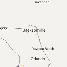
Florida
| Local Time | Report Details |
|---|---|
| 3:45 PM EDT | Porch roof blown off mobile home on hines dr in yeehaw junction. time estimated by radar. report relayed from osceola county emergency managemen in osceola county FL, 50.2 miles NW of Port Saint Lucie, FL |
| 5:24 PM EDT | Multiple trees and power lines down. time of event determined with rada in marion county FL, 73 miles NW of Orlando, FL |
North Carolina
| Local Time | Report Details |
|---|---|
| 4:42 PM EDT | Trees down on house and town hall. time estimated by radar and another report of a partial tree down in the area around 445 p in cumberland county NC, 53.5 miles S of Raleigh, NC |
| 7:30 PM EDT | Large limbs down blocking a portion of nc 53 near kelly. time estimated based off rada in bladen county NC, 33.9 miles NW of Wilmington, NC |
| 8:06 PM EDT | Trees down near stokes county lin in rockingham county NC, 61 miles S of Roanoke, VA |
| 8:45 PM EDT | Trees were reported down at the intersection of carlson dairy road and horse pen creek roa in guilford county NC, 73.8 miles WNW of Raleigh, NC |
| 8:51 PM EDT | Trees were reported down near the intersection of willoughby blvd and redford d in guilford county NC, 68.9 miles WNW of Raleigh, NC |
| 9:00 PM EDT | Trees were reported down near the intersection of immanuel road and south holden roa in guilford county NC, 69.8 miles WNW of Raleigh, NC |
| 9:02 PM EDT | Trees were reported down near the intersection of mobile street and randleman roa in guilford county NC, 67.2 miles WNW of Raleigh, NC |
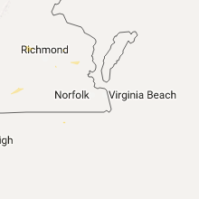
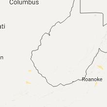
Virginia
| Local Time | Report Details |
|---|---|
| 5:00 PM EDT | Several large tree limbs down along monticello avenue near ironbound roa in james city county VA, 51.9 miles ESE of Richmond, VA |
| 6:20 PM EDT | Time is radar estimated. several trees and tree limbs downed along barger street... near intersection of battlefield and military hwy in chesapeak in city of chesapeake county VA, 11.7 miles W of Virginia Beach, VA |
| 6:30 PM EDT | Tree down on chalk level r in pittsylvania county VA, 43.8 miles SE of Roanoke, VA |
| 6:30 PM EDT | Tree down on chalk level r in pittsylvania county VA, 43.8 miles SE of Roanoke, VA |
| 6:45 PM EDT | Tree down on halifax rd. time radar estimate in pittsylvania county VA, 45.9 miles SE of Roanoke, VA |
Michigan
| Local Time | Report Details |
|---|---|
| 4:54 PM CDT | Power out in far southeast menominee. gust of 46mph at nearby marine observation platform mnmm in menominee county MI, 45.3 miles NNE of Green Bay, WI |
| 7:30 PM EDT | Trees down on power lin in grand traverse county MI, 9.6 miles W of Traverse City, MI |
| 7:58 PM EDT | Several trees reported down near the corner of hoxie and lautner r in leelanau county MI, 6.5 miles WNW of Traverse City, MI |
| 11:05 PM EDT | Midland county central dispatch reported some wires down in colema in midland county MI, 68.9 miles NW of Flint, MI |
Mississippi
| Local Time | Report Details |
|---|---|
| 5:55 PM CDT | Report via social media - picture of a tree down on steelman roa in lamar county MS, 84.2 miles SSE of Jackson, MS |
Texas
| Local Time | Report Details |
|---|---|
| 6:38 PM CDT | Quarter sized hail reported near Odessa, TX, 3.9 miles W of Odessa, TX |
| 6:44 PM CDT | Ping Pong Ball sized hail reported near Odessa, TX, 0.7 miles SSE of Odessa, TX |
| 6:46 PM CDT | Ping Pong Ball sized hail reported near Odessa, TX, 0.3 miles E of Odessa, TX, reported on 8th street in odessa |
| 6:53 PM CDT | Grapefruit sized hail reported near Odessa, TX, 7.1 miles ENE of Odessa, TX, hail left dents in cars and broke windsheilds. also caused damage to house shingles and windows. |
| 6:54 PM CDT | Baseball sized hail reported near Odessa, TX, 5.4 miles ENE of Odessa, TX |
| 6:57 PM CDT | Grapefruit sized hail reported near Odessa, TX, 7 miles NE of Odessa, TX, at the intersection of faudree rd and hwy 191. |
| 6:58 PM CDT | Hen Egg sized hail reported near Odessa, TX, 2.1 miles N of Odessa, TX |
| 6:58 PM CDT | Storm damage reported in ector county TX, 5 miles N of Odessa, TX |
| 7:02 PM CDT | Baseball sized hail reported near Odessa, TX, 8 miles ENE of Odessa, TX, at intersection of county rd 122 and 1308 |
| 7:02 PM CDT | Quarter sized hail reported near Midland, TX, 16.8 miles NE of Odessa, TX, at intersection of wadley and loop 250 |
| 7:07 PM CDT | Baseball sized hail reported near Midland, TX, 12.4 miles NE of Odessa, TX, ping pong to baseball size hail reported at intersection of county rd 1275 and hwy 191 |
| 7:08 PM CDT | Ping Pong Ball sized hail reported near Midland, TX, 12.5 miles ENE of Odessa, TX, half dollar to ping pong ball size hail at wfo midland. |
| 7:20 PM CDT | Ping Pong Ball sized hail reported near Midland, TX, 17.1 miles ENE of Odessa, TX |
| 7:24 PM CDT | Quarter sized hail reported near Midland, TX, 18.6 miles NE of Odessa, TX, near intersection of midland and wadley |
| 7:35 PM CDT | Tennis Ball sized hail reported near Colorado City, TX, 77.7 miles W of Abilene, TX |
| 7:38 PM CDT | Midland airpark reported a gust of 50 kt in midland county TX, 20.8 miles NE of Odessa, TX |
| 7:41 PM CDT | Storm damage reported in martin county TX, 38.9 miles NNE of Odessa, TX |
| 7:55 PM CDT | Golf Ball sized hail reported near Girard, TX, 70.9 miles ESE of Lubbock, TX, reported by the kent county sherriffs office. |
| 8:00 PM CDT | Spotter reported in northern mitchell count in mitchell county TX, 74.1 miles W of Abilene, TX |
| 8:04 PM CDT | Golf Ball sized hail reported near Knott, TX, 57.4 miles NE of Odessa, TX |
| 8:20 PM CDT | Golf Ball sized hail reported near Big Spring, TX, 64.6 miles NE of Odessa, TX, at intersection of route 1584 and 846. |
Kansas
| Local Time | Report Details |
|---|---|
| 8:39 PM CDT | Quarter sized hail reported near Douglass, KS, 20.8 miles SE of Wichita, KS |
| 9:53 PM CDT | Quarter sized hail reported near Rose Hill, KS, 11.5 miles ESE of Wichita, KS |
| 10:24 PM CDT | Quarter sized hail reported near Derby, KS, 10.3 miles SSE of Wichita, KS, quarter sized hail reported at 63rd street south and rock road. |
| 10:26 PM CDT | Half Dollar sized hail reported near Derby, KS, 10.3 miles SSE of Wichita, KS, public report via twitter of half dollar sized hail. |
| 10:30 PM CDT | Quarter sized hail reported near Rose Hill, KS, 13.9 miles SE of Wichita, KS |
| 10:40 PM CDT | Quarter sized hail reported near Wichita, KS, 5.7 miles SSE of Wichita, KS, quarter sized hail at 47th street south and clifton. there is also minor street flooding. |
Oklahoma
| Local Time | Report Details |
|---|---|
| 8:42 PM CDT | Quarter sized hail reported near Clinton, OK, 67.4 miles SSE of Woodward, OK, relayed by koco tv. |
| 8:44 PM CDT | Quarter sized hail reported near Clinton, OK, 67.4 miles SSE of Woodward, OK |
| 8:47 PM CDT | Quarter sized hail reported near Clinton, OK, 68.7 miles SSE of Woodward, OK, near lucky star casino. |
Connect with Interactive Hail Maps