

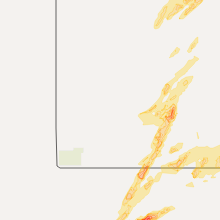
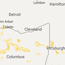
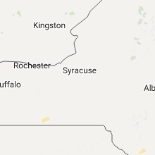
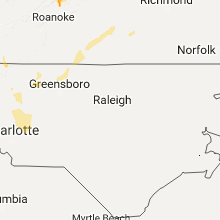
Hail Map for Tuesday, June 13, 2017

Number of Impacted Households on 6/13/2017
0
Impacted by 1" or Larger Hail
0
Impacted by 1.75" or Larger Hail
0
Impacted by 2.5" or Larger Hail
Square Miles of Populated Area Impacted on 6/13/2017
0
Impacted by 1" or Larger Hail
0
Impacted by 1.75" or Larger Hail
0
Impacted by 2.5" or Larger Hail


Cities Most Affected by Hail Storms of 6/13/2017
| Hail Size | Demographics of Zip Codes Affected | ||||||
|---|---|---|---|---|---|---|---|
| City | Count | Average | Largest | Pop Density | House Value | Income | Age |
| Canadian, TX | 5 | 2.35 | 2.75 | 3 | $57k | $35.4k | 35.6 |
| Grand Island, NE | 3 | 2.00 | 2.50 | 313 | $82k | $36.5k | 35.1 |
| Hastings, NE | 3 | 1.83 | 2.00 | 184 | $78k | $36.9k | 37.0 |
| Beaver, OK | 3 | 1.83 | 2.00 | 2 | $58k | $38.0k | 41.8 |
| Juniata, NE | 2 | 2.63 | 2.75 | 17 | $92k | $38.4k | 40.0 |
| Butte, NE | 2 | 1.88 | 2.00 | 3 | $24k | $25.0k | 47.5 |
| Holstein, NE | 1 | 2.50 | 2.50 | 3 | $44k | $42.2k | 40.8 |
| Atkinson, NE | 1 | 2.50 | 2.50 | 2 | $52k | $30.6k | 47.1 |
| Arnett, OK | 1 | 2.50 | 2.50 | 1 | $30k | $28.2k | 45.5 |
| Vinson, OK | 1 | 2.50 | 2.50 | 1 | $20k | $41.8k | 57.1 |
| Jetmore, KS | 1 | 2.00 | 2.00 | 2 | $48k | $34.5k | 43.8 |
| Redfield, SD | 1 | 2.00 | 2.00 | 10 | $41k | $30.8k | 45.0 |
| Hedley, TX | 1 | 2.00 | 2.00 | 1 | $19k | $31.1k | 43.4 |
| Fargo, OK | 1 | 2.00 | 2.00 | 2 | $51k | $31.0k | 43.0 |
| Ashland, KS | 1 | 1.75 | 1.75 | 0 | $37k | $34.7k | 44.3 |
| Long Pine, NE | 1 | 1.75 | 1.75 | 1 | $30k | $25.2k | 44.3 |
| Agra, KS | 1 | 1.75 | 1.75 | 3 | $23k | $27.9k | 48.6 |
| Higgins, TX | 1 | 1.75 | 1.75 | 0 | $28k | $28.9k | 48.4 |
| Stuart, NE | 1 | 1.75 | 1.75 | 2 | $53k | $30.7k | 47.1 |
| Mobeetie, TX | 1 | 1.75 | 1.75 | 2 | $33k | $33.8k | 44.5 |
| Miami, TX | 1 | 1.75 | 1.75 | 1 | $48k | $38.1k | 40.5 |
| Dimock, SD | 1 | 1.75 | 1.75 | 5 | $52k | $38.8k | 41.9 |
| Newport, NE | 1 | 1.75 | 1.75 | 1 | $15k | $32.7k | 50.8 |
| Booker, TX | 1 | 1.75 | 1.75 | 2 | $46k | $33.2k | 31.5 |
| Anselmo, NE | 1 | 1.75 | 1.75 | 1 | $33k | $32.0k | 45.5 |
Hail and Wind Damage Spotted on 6/13/2017
Filter by Report Type:Hail ReportsWind Reports
States Impacted
South Dakota, Ohio, North Dakota, Minnesota, Indiana, West Virginia, Kentucky, New York, North Carolina, Virginia, Illinois, South Carolina, Pennsylvania, Nebraska, Massachusetts, Texas, Mississippi, Oklahoma, Kansas, Montana, New Jersey, Iowa, WisconsinSouth Dakota
| Local Time | Report Details |
|---|---|
| 7:13 AM CDT | Quarter sized hail reported near Watertown, SD, 71.3 miles W of Montevideo, MN, pea to quarter size hail. |
| 3:45 PM CDT | Ping Pong Ball sized hail reported near Burke, SD, 59.6 miles NNW of Oneill, NE |
| 3:50 PM CDT | Quarter sized hail reported near Miller, SD, 56.8 miles SSW of Aberdeen, SD |
| 4:30 PM CDT | Ping Pong Ball sized hail reported near Rockham, SD, 42.3 miles SSW of Aberdeen, SD |
| 4:45 PM CDT | Hen Egg sized hail reported near Redfield, SD, 41.7 miles SSW of Aberdeen, SD |
| 5:14 PM CDT | Quarter sized hail reported near Fort Thompson, SD, 49.5 miles ESE of Pierre, SD |
| 5:19 PM CDT | Ping Pong Ball sized hail reported near Platte, SD, 65.1 miles N of Oneill, NE |
| 5:20 PM CDT | Tree limbs dow in spink county SD, 21.6 miles SSE of Aberdeen, SD |
| 5:25 PM CDT | Power pole snapped. radar estimated tim in spink county SD, 21.6 miles SSE of Aberdeen, SD |
| 5:26 PM CDT | Quarter sized hail reported near Platte, SD, 62.6 miles N of Oneill, NE |
| 5:30 PM CDT | Storm damage reported in spink county SD, 20.7 miles S of Aberdeen, SD |
| 5:31 PM CDT | Quarter sized hail reported near Harrison, SD, 69.2 miles N of Oneill, NE |
| 5:52 PM CDT | Tree down. (report via social media in sanborn county SD, 84.7 miles WNW of Sioux Falls, SD |
| 5:56 PM CDT | Quarter sized hail reported near Pickstown, SD, 42.7 miles N of Oneill, NE |
| 5:59 PM CDT | Quarter sized hail reported near Plankinton, SD, 86.9 miles W of Sioux Falls, SD, also 50 to 60 mph winds. |
| 6:07 PM CDT | Quarter sized hail reported near Lake Andes, SD, 48.8 miles N of Oneill, NE |
| 6:18 PM CDT | Blew off previously damaged barn roof. time estimated from rada in beadle county SD, 70.6 miles SSE of Aberdeen, SD |
| 6:20 PM CDT | Flag pole down and shingles blown off barn roo in beadle county SD, 80.3 miles SSE of Aberdeen, SD |
| 6:20 PM CDT | Multiple trees downed within tow in beadle county SD, 78.5 miles SSE of Aberdeen, SD |
| 6:20 PM CDT | Power lines downe in beadle county SD, 83.1 miles NW of Sioux Falls, SD |
| 6:23 PM CDT | Quarter sized hail reported near Mount Vernon, SD, 77.7 miles W of Sioux Falls, SD |
| 6:32 PM CDT | Storm damage reported in beadle county SD, 76.8 miles SSE of Aberdeen, SD |
| 6:34 PM CDT | Golf Ball sized hail reported near Dimock, SD, 73.4 miles W of Sioux Falls, SD |
| 6:35 PM CDT | Storm damage reported in hutchinson county SD, 64.1 miles W of Sioux Falls, SD |
| 6:42 PM CDT | Quarter sized hail reported near Mitchell, SD, 68.5 miles W of Sioux Falls, SD |
| 6:42 PM CDT | Ping Pong Ball sized hail reported near Mitchell, SD, 71.3 miles W of Sioux Falls, SD |
| 6:58 PM CDT | Shed roof removed... several trees down. radar estimated tim in clark county SD, 54.5 miles SE of Aberdeen, SD |
| 6:58 PM CDT | Recorded by a full mobile mesonet. radar estimated tim in clark county SD, 55 miles SE of Aberdeen, SD |
| 7:05 PM CDT | Storm damage reported in clark county SD, 58.8 miles SE of Aberdeen, SD |
| 7:12 PM CDT | Quarter sized hail reported near Tripp, SD, 63.5 miles NNE of Oneill, NE |
| 7:18 PM CDT | Large trees uprooted. radar estimated tim in codington county SD, 55.3 miles ESE of Aberdeen, SD |
| 7:25 PM CDT | 60 mp in codington county SD, 62.8 miles ESE of Aberdeen, SD |
| 7:31 PM CDT | Radar estimated tim in day county SD, 43.5 miles E of Aberdeen, SD |
| 7:31 PM CDT | Several power poles down. time estimated via rada in day county SD, 41.6 miles E of Aberdeen, SD |
| 7:32 PM CDT | Powerlines down in webster. time estimated via rada in day county SD, 47.8 miles E of Aberdeen, SD |
| 7:33 PM CDT | At least 65 mph estimate in day county SD, 54.4 miles ESE of Aberdeen, SD |
| 7:34 PM CDT | Three power poles down. time estimated via rada in day county SD, 45.8 miles E of Aberdeen, SD |
| 7:35 PM CDT | Dairy barn partially destroyed. time estimated via rada in day county SD, 55.5 miles E of Aberdeen, SD |
| 7:35 PM CDT | Storm damage reported in day county SD, 48.5 miles ESE of Aberdeen, SD |
| 7:37 PM CDT | A lot of damage throughout town...including trees uprooted and on houses. power outages across day county. time estimated via rada in day county SD, 57.9 miles E of Aberdeen, SD |
| 7:46 PM CDT | Storm damage reported in turner county SD, 32.8 miles W of Sioux Falls, SD |
| 7:50 PM CDT | Storm damage reported in day county SD, 54 miles E of Aberdeen, SD |
| 8:05 PM CDT | Time estimate in marshall county SD, 55.5 miles ENE of Aberdeen, SD |
| 8:10 PM CDT | Multiple trees down... electrical lines down. possible fires started due to electrical lines dow in grant county SD, 48.8 miles WNW of Montevideo, MN |
| 8:14 PM CDT | Storm damage reported in roberts county SD, 71.8 miles SSW of Fargo, ND |
| 8:20 PM CDT | Storm damage reported in roberts county SD, 69.8 miles S of Fargo, ND |
| 8:20 PM CDT | Two cabins destroyed... one by wind and the other by a large felled tree. radar estimated time. estimated locatio in roberts county SD, 73.4 miles NW of Montevideo, MN |
| 8:22 PM CDT | Quarter sized hail reported near Hurley, SD, 25.7 miles SW of Sioux Falls, SD |
| 8:22 PM CDT | Quarter sized hail reported near Parker, SD, 20.6 miles WSW of Sioux Falls, SD |
| 8:24 PM CDT | Quarter sized hail reported near Humboldt, SD, 18 miles W of Sioux Falls, SD |
| 8:28 PM CDT | 12-16" trees snapped. possible tornado damage. radar estimated tim in roberts county SD, 66.2 miles S of Fargo, ND |
| 8:36 PM CDT | Half Dollar sized hail reported near Parker, SD, 22.9 miles WSW of Sioux Falls, SD, relayed via turner county em. |
| 8:40 PM CDT | Ping Pong Ball sized hail reported near Parker, SD, 22 miles WSW of Sioux Falls, SD |
| 8:40 PM CDT | Storm damage reported in minnehaha county SD, 11.7 miles WNW of Sioux Falls, SD |
| 8:57 PM CDT | Storm damage reported in turner county SD, 18.4 miles SW of Sioux Falls, SD |
| 9:05 PM CDT | 65 to 75 estimate in minnehaha county SD, 7.2 miles N of Sioux Falls, SD |
| 9:07 PM CDT | Quarter sized hail reported near Sioux Falls, SD, 8 miles W of Sioux Falls, SD |
| 9:10 PM CDT | Roof torn off of mobile hom in minnehaha county SD, 3 miles W of Sioux Falls, SD |
| 9:13 PM CDT | Estimated at nws offic in minnehaha county SD, 3.1 miles N of Sioux Falls, SD |
| 9:15 PM CDT | Via sdsu mesonet beresford sit in clay county SD, 35.2 miles SSW of Sioux Falls, SD |
| 9:15 PM CDT | Large tree uproote in minnehaha county SD, 3.1 miles SW of Sioux Falls, SD |
| 9:16 PM CDT | Storm damage reported in lincoln county SD, 8.2 miles SW of Sioux Falls, SD |
| 9:21 PM CDT | Quarter sized hail reported near Sioux Falls, SD, 4.9 miles SSW of Sioux Falls, SD, hail just ended. |
| 9:30 PM CDT | Report via social medi in union county SD, 32.2 miles S of Sioux Falls, SD |
Ohio
| Local Time | Report Details |
|---|---|
| 10:11 AM EDT | One tree dow in franklin county OH, 4.2 miles WSW of Columbus, OH |
| 10:15 AM EDT | Tree blown onto mobile home on volney ave. time estimated by rada in franklin county OH, 4.7 miles W of Columbus, OH |
| 11:50 AM EDT | Small trees snapped off about 3 feet from the ground and large branches snapped off of oak trees. time estimated by rada in highland county OH, 40.8 miles E of Cincinnati, OH |
| 12:29 PM EDT | Quarter sized hail reported near Oxford, OH, 30.3 miles NNW of Cincinnati, OH |
| 12:31 PM EDT | Wires down on riggs road. time estimated by rada in butler county OH, 31.8 miles NNW of Cincinnati, OH |
| 12:38 PM EDT | Wires down on mercedes drive. time estimated by rada in butler county OH, 21.8 miles N of Cincinnati, OH |
| 12:54 PM EDT | Trees down at the intersection of taywood and westbrook rd. time estimated from rada in montgomery county OH, 51.2 miles NNE of Cincinnati, OH |
| 1:20 PM EDT | Trees down along salem avenue. time estimated from rada in montgomery county OH, 49.7 miles NNE of Cincinnati, OH |
| 1:20 PM EDT | Several large branches down. video posted on social medi in montgomery county OH, 53.1 miles NNE of Cincinnati, OH |
| 1:22 PM EDT | Large tree split in half on marylew lane. time estimated by rada in montgomery county OH, 52.9 miles NNE of Cincinnati, OH |
| 1:42 PM EDT | Tree down on woodcliff dr. time estimated from rada in miami county OH, 62.2 miles W of Columbus, OH |
| 2:17 PM EDT | Quarter sized hail reported near Tippecanoe, OH, 69.2 miles W of Pittsburgh, PA, hail at least the size of a quarter along norris road |
| 2:56 PM EDT | Half Dollar sized hail reported near East Canton, OH, 53.7 miles SSE of Cleveland, OH |
| 3:03 PM EDT | Several telephone poles and trees reported down in the troy township are in richland county OH, 54.1 miles NNE of Columbus, OH |
| 3:18 PM EDT | Ping Pong Ball sized hail reported near Louisville, OH, 50.7 miles SSE of Cleveland, OH |
| 3:40 PM EDT | Multiple trees down in knox county. apple valley rd. danville amity road... beacon rd and jonathan driv in knox county OH, 51.5 miles NE of Columbus, OH |
| 3:45 PM EDT | Several large trees down near indian mill on route 47 in wyandot county OH, 62.2 miles NNW of Columbus, OH |
| 4:35 PM EDT | Multiple large tree limbs down in the green springs area. state route 101 and state 778 in seneca county OH, 80.4 miles N of Columbus, OH |
| 4:50 PM EDT | Several reports of trees and powerlines down in the cardington area. also reports of trees down near iberia in morrow county OH, 37.6 miles N of Columbus, OH |
| 5:10 PM EDT | Trees snapped... a few uprooted. no details on size or health provide in allen county OH, 52.5 miles ESE of Fort Wayne, IN |
| 5:16 PM EDT | Quarter sized hail reported near Defiance, OH, 41 miles ENE of Fort Wayne, IN, pea up through quarter-sized hail. |
| 5:30 PM EDT | Light pole snapped in half on east second stree in defiance county OH, 41.5 miles ENE of Fort Wayne, IN |
| 5:35 PM EDT | Power poles downed on hire road. pea sized hail also observe in defiance county OH, 42.3 miles ENE of Fort Wayne, IN |
| 6:05 PM EDT | Poles... powerlines and some tree branches near benton ridge in hancock county OH, 69.6 miles E of Fort Wayne, IN |
| 7:09 PM EDT | Trees and power lines down. time estimated in auglaize county OH, 49.6 miles SE of Fort Wayne, IN |
| 7:11 PM EDT | Trees and powerlines down throughout western part of auglaize county... including in st. marys. time estimated by rada in auglaize county OH, 52.4 miles SE of Fort Wayne, IN |
| 7:18 PM EDT | Tree down across road near intersection of sr 31 and county road 190. time estimated by rada in hardin county OH, 51.5 miles NW of Columbus, OH |
| 7:20 PM EDT | Several trees down and powerlines down north of grand lake in eastern part of county. time estimated by rada in mercer county OH, 47.5 miles SE of Fort Wayne, IN |
| 7:20 PM EDT | Several large trees and limbs down at northmoor golf course. sheet metal roofing partially removed from structure. time estimated by rada in mercer county OH, 48.7 miles SE of Fort Wayne, IN |
| 7:30 PM EDT | Quarter sized hail reported near Gibsonburg, OH, 88.8 miles W of Cleveland, OH |
| 7:41 PM EDT | Several trees downed in botkins area. time estimated by rada in shelby county OH, 63.8 miles SE of Fort Wayne, IN |
| 7:55 PM EDT | Several trees downed in jackson center area. time estimated by rada in shelby county OH, 64 miles WNW of Columbus, OH |
| 8:11 PM EDT | Tree down along county road 21. time estimated by rada in logan county OH, 58.2 miles WNW of Columbus, OH |
| 8:25 PM EDT | Tree down along county road 11. time estimated by rada in logan county OH, 51.4 miles WNW of Columbus, OH |
| 8:44 PM EDT | 2 trees down and damage to barn sidin in shelby county OH, 65.2 miles SE of Fort Wayne, IN |
| 8:48 PM EDT | Large branch on wire. time estimated from rada in union county OH, 27.7 miles NW of Columbus, OH |
North Dakota
| Local Time | Report Details |
|---|---|
| 9:55 AM CDT | Storm damage reported in walsh county ND, 71.3 miles ENE of Devils Lake, ND |
| 6:20 PM CDT | Quarter sized hail reported near Kintyre, ND, 52.3 miles SE of Bismarck, ND, hail lasted about 2 minutes. |
| 7:35 PM CDT | Half Dollar sized hail reported near Cogswell, ND, 49.6 miles NE of Aberdeen, SD, hail and heavy rain. |
| 8:15 PM CDT | A few large 4-6 inch diamter tree limbs broken dow in ransom county ND, 57.7 miles SW of Fargo, ND |
| 8:30 PM CDT | Unspecified damages at the dakota magic casino. trees blown down in the area. time estimated based on rada in richland county ND, 64.7 miles S of Fargo, ND |
| 8:30 PM CDT | Quarter sized hail reported near Enderlin, ND, 42.1 miles WSW of Fargo, ND |
| 8:35 PM CDT | Peak winds measured at the sheyenne raws station... sngn8. time estimated from rada in ransom county ND, 38.4 miles SW of Fargo, ND |
| 8:54 PM CDT | A few 3 to 4 inch branches broken down. reported via social medi in cass county ND, 5.6 miles W of Fargo, ND |
| 9:00 PM CDT | Stop sign bent over. reported via social medi in richland county ND, 20.5 miles S of Fargo, ND |
| 9:04 PM CDT | Very strong winds for a minute or mor in cass county ND, 5 miles SW of Fargo, ND |
| 9:07 PM CDT | Severe wind gusts for several minute in cass county ND, 4.1 miles NW of Fargo, ND |
| 9:13 PM CDT | Peak winds measured at an rwis statio in richland county ND, 41.9 miles S of Fargo, ND |
| 9:13 PM CDT | Peak winds measured at a personal weather statio in cass county ND, 28.5 miles NW of Fargo, ND |
| 9:15 PM CDT | Peak winds estimated to 70 mph downtown. some street flooding bginnin in cass county ND, 1.8 miles W of Fargo, ND |
| 9:28 PM CDT | Storm damage reported in cass county ND, 15.4 miles NNW of Fargo, ND |
| 9:30 PM CDT | Large tree blown down in argusvill in cass county ND, 14.2 miles NNW of Fargo, ND |
Minnesota
| Local Time | Report Details |
|---|---|
| 10:06 AM CDT | Quarter sized hail reported near Crosby, MN, 80.7 miles SSE of Bemidji, MN |
| 10:18 AM CDT | Peak winds measured at an ndawn station between warren and tabo in polk county MN, 70.4 miles SW of Roseau, MN |
| 2:00 PM CDT | Three-inch diameter limbs broken off trees. two trees of 8 to 10 inch diameter had tops broken of in lake of the woods county MN, 37.7 miles E of Roseau, MN |
| 3:35 PM CDT | Quarter sized hail reported near Mahnomen, MN, 39.9 miles WSW of Bemidji, MN, very heavy rain and dime to quarter sized hail. |
| 3:35 PM CDT | Quarter sized hail reported near Lengby, MN, 37 miles W of Bemidji, MN, very heavy rain and dime to quarter sized hail. |
| 3:45 PM CDT | Half Dollar sized hail reported near Lengby, MN, 35.2 miles W of Bemidji, MN, a few nickel to half dollar hail in very heavy rain. |
| 4:06 PM CDT | Quarter sized hail reported near Bemidji, MN, 10.8 miles N of Bemidji, MN, along irvine ave. |
| 6:45 PM CDT | Ping Pong Ball sized hail reported near Hancock, MN, 38 miles N of Montevideo, MN |
| 7:00 PM CDT | Trees dow in stevens county MN, 42.8 miles N of Montevideo, MN |
| 7:05 PM CDT | Quarter sized hail reported near Nashua, MN, 61.7 miles SSE of Fargo, ND, a few dime to quarter sized hail and brief heavy rain. |
| 7:22 PM CDT | Half Dollar sized hail reported near Donnelly, MN, 52.9 miles NNW of Montevideo, MN, photo submitted via facebook. |
| 7:35 PM CDT | Quarter sized hail reported near Kent, MN, 32.2 miles SSE of Fargo, ND, a few dime to quarter sized hail. |
| 8:20 PM CDT | Time estimated by rada in big stone county MN, 55.1 miles NW of Montevideo, MN |
| 8:20 PM CDT | Multiple trees snapped... multiple large branches down... and electrical lines dow in big stone county MN, 42.7 miles NW of Montevideo, MN |
| 8:20 PM CDT | 13 miles ne of ortonville. wind caved in the sides of two grain bins. wind estimate 70+ mp in big stone county MN, 42.6 miles NW of Montevideo, MN |
| 8:23 PM CDT | Time estimate in big stone county MN, 37.1 miles NW of Montevideo, MN |
| 8:29 PM CDT | Multiple trees snapped and uprooted in clinto in big stone county MN, 49.8 miles NW of Montevideo, MN |
| 8:35 PM CDT | Storm damage reported in big stone county MN, 56.4 miles NW of Montevideo, MN |
| 8:40 PM CDT | Half Dollar sized hail reported near Campbell, MN, 57.2 miles SSE of Fargo, ND |
| 8:47 PM CDT | Trees and power-lines dow in stevens county MN, 45.8 miles NNW of Montevideo, MN |
| 8:55 PM CDT | Estimated wind gusts with large 18 inch diameter trees blown down. small shed blown dow in wilkin county MN, 44.9 miles SSE of Fargo, ND |
| 9:02 PM CDT | Reported via social medi in wilkin county MN, 49.4 miles SSE of Fargo, ND |
| 9:05 PM CDT | Estimated wind gusts with large 18 inch diameter trees blown dow in wilkin county MN, 44.9 miles SSE of Fargo, ND |
| 9:10 PM CDT | Peak winds measured at an rwis statio in clay county MN, 6.3 miles ESE of Fargo, ND |
| 9:12 PM CDT | Four tractor-trailer rigs were blown over on i-94 near rothsay. rothsay rwis power outage occurred at about this tim in wilkin county MN, 36.5 miles SE of Fargo, ND |
| 9:14 PM CDT | Peak winds measured at the fergus falls airpor in otter tail county MN, 54.9 miles SE of Fargo, ND |
| 9:20 PM CDT | Tree limbs down around town. some minor street flooding beginnin in otter tail county MN, 53.3 miles SE of Fargo, ND |
| 9:22 PM CDT | Branches & tree limbs dow in douglas county MN, 69.4 miles N of Montevideo, MN |
| 9:29 PM CDT | Some tree limbs broken dow in otter tail county MN, 78.1 miles SE of Fargo, ND |
| 9:35 PM CDT | Peak winds measured at an rwis statio in becker county MN, 31.8 miles E of Fargo, ND |
| 9:35 PM CDT | Peak winds measured at an rwis statio in clay county MN, 6.3 miles ESE of Fargo, ND |
| 9:45 PM CDT | Gust via beaver creek mndot rwi in rock county MN, 18.2 miles ENE of Sioux Falls, SD |
| 9:55 PM CDT | Ping Pong Ball sized hail reported near Bigfork, MN, 67.2 miles S of International Falls, MN, time estimated from radar. |
| 9:55 PM CDT | A large tree was down along the highwa in becker county MN, 48.8 miles E of Fargo, ND |
| 10:16 PM CDT | Social media report via personal weather statio in lyon county MN, 34.8 miles S of Montevideo, MN |
| 10:24 PM CDT | Quarter sized hail reported near Adrian, MN, 37.7 miles E of Sioux Falls, SD, social media report with picture. |
| 10:55 PM CDT | Measured via mndot rwi in cottonwood county MN, 67 miles SSE of Montevideo, MN |
| 11:24 PM CDT | Crow wing county sheriff took a report of a tree that was downed and took down a powerline. time estimated from rada in crow wing county MN, 62 miles SE of Bemidji, MN |
| 12:02 AM CDT | Co rd. 10 closed between co rd 30 and waconia parkway due to downed power lin in carver county MN, 28.4 miles WSW of Minneapolis, MN |
| 12:05 AM CDT | Mesonet station mn022... new germany 1n in carver county MN, 35.9 miles W of Minneapolis, MN |
| 12:22 AM CDT | Measured at flying cloud airpor in hennepin county MN, 14.4 miles SW of Minneapolis, MN |
| 12:30 AM CDT | Roof blown off of a pole shed building. time of damage is estimate in scott county MN, 23 miles SSW of Minneapolis, MN |
| 12:40 AM CDT | Hwy 3 closed by downed power line in dakota county MN, 24.1 miles SSE of Minneapolis, MN |
| 12:40 AM CDT | Hwy 3 closed by downed power line in dakota county MN, 24.1 miles SSE of Minneapolis, MN |
| 12:45 AM CDT | 5" diameter tree snappe in ramsey county MN, 6.3 miles SE of Minneapolis, MN |
| 1:10 AM CDT | Storm damage reported in chisago county MN, 45.5 miles NNE of Minneapolis, MN |
Indiana
| Local Time | Report Details |
|---|---|
| 11:21 AM EDT | Trees down. time estimated based on rada in dearborn county IN, 20.4 miles WNW of Cincinnati, OH |
| 11:55 AM EDT | Barn damaged and several trees down along whiteland road. likely microburst. reported by bam w in johnson county IN, 15.9 miles S of Indianapolis, IN |
| 11:55 AM EDT | Home sustained minor shingle damag in johnson county IN, 14.5 miles S of Indianapolis, IN |
| 1:47 PM EDT | Quarter sized hail reported near Zionsville, IN, 14.2 miles NNW of Indianapolis, IN, at the zionsville town hall. |
| 2:00 PM EDT | Quarter sized hail reported near Elkhart, IN, 61.3 miles NW of Fort Wayne, IN, pea to quarter sized hail observed. |
| 2:34 PM EDT | Estimated 50-60 mph wind gust. no report of damage yet... too hard to tell with ongoing stor in elkhart county IN, 51.9 miles NW of Fort Wayne, IN |
| 4:15 PM EDT | Correction for location: small to medium sized trees down with fencing at old 27. cattle got loose as a result of damage but are now containe in de kalb county IN, 31.5 miles N of Fort Wayne, IN |
| 4:15 PM EDT | Small to medium sized trees down with fencing at old 27.. cattle got loose as a result of damage but are now containe in steuben county IN, 31.7 miles N of Fort Wayne, IN |
| 5:35 PM EDT | Reports of multiple trees down in south whitley area. large... healthy trees. winds estimated at 50-60 mph and nickle sized hail also observed at sr 14 and cr 70 in kosciusko county IN, 31.4 miles W of Fort Wayne, IN |
| 5:42 PM EDT | Tree damage on w river road. trees were large and health in whitley county IN, 29.3 miles W of Fort Wayne, IN |
| 5:42 PM EDT | Tree damage reported at river rd & cr s 950 in whitley county IN, 29.8 miles W of Fort Wayne, IN |
| 5:43 PM EDT | Power lines downed on w 700 s between 850w and 900 in whitley county IN, 29.3 miles W of Fort Wayne, IN |
| 5:49 PM EDT | Tree damage on 500 s just west of sr 5. trees were large and health in whitley county IN, 27.7 miles W of Fort Wayne, IN |
| 6:00 PM CDT | Half Dollar sized hail reported near Valparaiso, IN, 41.1 miles SE of Chicago, IL |
| 6:07 PM CDT | Quarter sized hail reported near Valparaiso, IN, 41.1 miles SE of Chicago, IL |
West Virginia
| Local Time | Report Details |
|---|---|
| 11:25 AM EDT | Ham radio operator reports downed trees along stanaford rd. with arcing power lines. time est. from radar in raleigh county WV, 45.8 miles SE of Charleston, WV |
| 2:10 PM EDT | Tree down on burch ridge but doubtful to have been caused by severe wind in marshall county WV, 62.7 miles SW of Pittsburgh, PA |
| 2:16 PM EDT | Tree down on middle grave creek road in marshall county WV, 49.7 miles SW of Pittsburgh, PA |
| 2:17 PM EDT | Limbs reported down along route 250 in marshall county WV, 49.3 miles SW of Pittsburgh, PA |
| 2:59 PM EDT | Multiple trees down around the keystone area in marion county WV, 49.3 miles NNW of Elkins, WV |
Kentucky
| Local Time | Report Details |
|---|---|
| 1:42 PM EDT | One large tree limb down. time estimated by rada in grant county KY, 32.2 miles S of Cincinnati, OH |
| 5:40 PM EDT | A few trees were reported down. event time estimated from rada in leslie county KY, 49.9 miles SE of Irvine, KY |
| 5:55 PM EDT | A tree was reorted down along u.s. hwy 42 in leslie county KY, 56.3 miles SE of Irvine, KY |
| 6:05 PM EDT | 2 trees were downe in harlan county KY, 62.5 miles WNW of Bristol, TN |
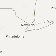
New York
| Local Time | Report Details |
|---|---|
| 2:08 PM EDT | Tree on home in dutchess county NY, 65.8 miles S of Schenectady, NY |
| 2:09 PM EDT | Tree and wires down in dutchess county NY, 65.8 miles S of Schenectady, NY |
| 2:15 PM EDT | Multiple trees down along browning roa in dutchess county NY, 68 miles S of Schenectady, NY |
| 2:25 PM EDT | Tree and wires down near hahns fams on salt pt. turnpike in dutchess county NY, 70.2 miles S of Schenectady, NY |
| 2:29 PM EDT | Tree and wires down in roadway in dutchess county NY, 70 miles S of Schenectady, NY |
| 3:09 PM EDT | Tree and wires dow in dutchess county NY, 65.1 miles N of Brooklyn, NY |
| 3:10 PM EDT | Tree and wires in roadway in dutchess county NY, 65.2 miles N of Brooklyn, NY |
| 3:30 PM EDT | Large tree limbs down in dutchess county NY, 63.8 miles NNE of Brooklyn, NY |
| 4:17 PM EDT | Downed tree on intersection of route 312 and route 2 in putnam county NY, 55.2 miles NNE of Brooklyn, NY |
| 4:41 PM EDT | Campers damaged by flying picnic table. golf cart overturne in columbia county NY, 51.8 miles SSE of Schenectady, NY |
| 7:00 PM EDT | Numerous trees down across tow in orange county NY, 45.7 miles NNW of Brooklyn, NY |
| 7:03 PM EDT | Numerous trees down around tow in orange county NY, 46 miles N of Brooklyn, NY |
| 7:08 PM EDT | Quarter sized hail reported near Monroe, NY, 44.5 miles NNW of Brooklyn, NY, dime to quarter size hail measured from monroe to south blooming grove |
| 7:53 PM EDT | Tree down on mountain farm road and west lake roa in orange county NY, 36.9 miles NNW of Brooklyn, NY |
North Carolina
| Local Time | Report Details |
|---|---|
| 2:10 PM EDT | Trees down in the vicinity of laurel par in henderson county NC, 33.7 miles NNE of Greenville, SC |
| 3:09 PM EDT | Tree dow in yadkin county NC, 66.7 miles N of Charlotte, NC |
| 3:10 PM EDT | Large tree down... along with small wood fenc in yadkin county NC, 66.7 miles N of Charlotte, NC |
| 3:12 PM EDT | Trres and powerlines dow in caldwell county NC, 53.2 miles NW of Charlotte, NC |
| 3:15 PM EDT | Tree down on sawmills school r in caldwell county NC, 54.3 miles NW of Charlotte, NC |
| 3:15 PM EDT | Quarter sized hail reported near Spruce Pine, NC, 47.1 miles S of Bristol, TN, 1 inch hail reported in spruce pine |
| 3:20 PM EDT | Numerous large trees down blocking dry ponds rd and 321a in caldwell county NC, 53.4 miles NW of Charlotte, NC |
| 3:30 PM EDT | Trees down in kin in stokes county NC, 72.2 miles SSW of Roanoke, VA |
| 3:30 PM EDT | Several trees down. dime sized hail reported near the hosipta in stokes county NC, 61.8 miles SSW of Roanoke, VA |
| 3:35 PM EDT | Trees down near intersection of blue creek road and navajo wa in caldwell county NC, 60.5 miles SE of Bristol, TN |
| 3:42 PM EDT | Tree down blocking rod in hamptonville. relayed via twitter from wfmy. time radar estimate in yadkin county NC, 61.9 miles N of Charlotte, NC |
| 3:45 PM EDT | Trees down 3110 18th street ne hickor in catawba county NC, 45.3 miles NW of Charlotte, NC |
| 3:51 PM EDT | Trees and power lines down at intersection of i-40 and fairgrove church road. i-40 reported to be shut down at this poin in catawba county NC, 40.6 miles NW of Charlotte, NC |
| 4:00 PM EDT | Power lines down at exit 128 and i40 in catawba county NC, 40.6 miles NW of Charlotte, NC |
| 4:00 PM EDT | Quarter sized hail reported near Conover, NC, 41 miles NW of Charlotte, NC, quarter size hail reported along highway 70 near hickory motor speedway. |
| 4:05 PM EDT | Trees down 3110 18th street ne hickor in catawba county NC, 45.3 miles NW of Charlotte, NC |
| 4:05 PM EDT | Trees down 1515 4th street sw in conover in catawba county NC, 40.6 miles NW of Charlotte, NC |
| 4:12 PM EDT | 2 trres down on rock springs roa in iredell county NC, 52.7 miles N of Charlotte, NC |
| 4:13 PM EDT | Trees and power lines down along tomin mills roa in iredell county NC, 48.1 miles N of Charlotte, NC |
| 4:13 PM EDT | Also 0.5 inch hail and heavy rai in iredell county NC, 52.6 miles N of Charlotte, NC |
| 4:17 PM EDT | Power lines down at emmanual church road and east nc highway 1 in catawba county NC, 37.9 miles NNW of Charlotte, NC |
| 4:20 PM EDT | A tree was reported down on power lines... resulting in a fir in guilford county NC, 71.2 miles S of Roanoke, VA |
| 4:27 PM EDT | A few trees were blown down on the propert in davie county NC, 50.8 miles N of Charlotte, NC |
| 4:27 PM EDT | Ping Pong Ball sized hail reported near Harmony, NC, 50.8 miles N of Charlotte, NC, up to 1.5 inch hail. |
| 4:30 PM EDT | A few large limbs down and pea sized hai in cleveland county NC, 37.5 miles W of Charlotte, NC |
| 4:30 PM EDT | Trees down on county line road west of statesvill in alexander county NC, 43.7 miles NNW of Charlotte, NC |
| 4:35 PM EDT | Trees down on silver welch roa in mcdowell county NC, 58.1 miles NNE of Greenville, SC |
| 4:37 PM EDT | 8 to 10 trees blown over or uprooted on salem church road and a house with roof damage on silvers welch road. other damage to a tractor and small building damage in mcdowell county NC, 58.2 miles NNE of Greenville, SC |
| 4:48 PM EDT | Guilford county 911 received report of tree down across road at oakridge meadows in greensbor in guilford county NC, 73.8 miles WNW of Raleigh, NC |
| 5:00 PM EDT | Trees and power lines down mill bridge road and weaver roa in rowan county NC, 30.9 miles NNE of Charlotte, NC |
| 5:03 PM EDT | Guilford county 911 received report of tree down across road at kirkpatrick place in greensbor in guilford county NC, 68.9 miles WNW of Raleigh, NC |
| 5:03 PM EDT | Guilford county 911 received report of tree down across road on pineburr rd in greensbor in guilford county NC, 70.7 miles WNW of Raleigh, NC |
| 5:06 PM EDT | Tree blown over and a street sign blown dow in mecklenburg county NC, 6 miles NNE of Charlotte, NC |
| 5:08 PM EDT | Public reported a downed tree at the intersection of miller rd. and w. church st. (nc 152) in china grov in rowan county NC, 28.6 miles NNE of Charlotte, NC |
| 5:21 PM EDT | Trees down blocking road... west church street at west ketchie street in the town of china grov in rowan county NC, 28 miles NNE of Charlotte, NC |
| 5:30 PM EDT | A few large limbs down and pea sized hai in cleveland county NC, 37.5 miles W of Charlotte, NC |
| 5:45 PM EDT | At least 2 trees down in the area with one tree falling on highway 25 blocking traffi in henderson county NC, 32.6 miles NNE of Greenville, SC |
| 5:55 PM EDT | Tree down on memory lan in cabarrus county NC, 18.7 miles ENE of Charlotte, NC |
| 6:15 PM EDT | Large tree and power lines down on glade valley roa in alleghany county NC, 70.4 miles E of Bristol, TN |
| 6:20 PM EDT | Tree down on blackberry trai in cabarrus county NC, 14.5 miles NNE of Charlotte, NC |
| 6:20 PM EDT | Tree on power lines on falmouth rd. time estimate in mecklenburg county NC, 3.8 miles E of Charlotte, NC |
| 6:30 PM EDT | Tree down near intersection of caldwell rd and tom query r in cabarrus county NC, 11.2 miles ENE of Charlotte, NC |
Virginia
| Local Time | Report Details |
|---|---|
| 2:42 PM EDT | Tree down on wayne st ne. time radar estimate in city of roanoke county VA, 1.4 miles NNE of Roanoke, VA |
| 2:42 PM EDT | Tree down on dale ave. time radar estimate in city of roanoke county VA, 1.7 miles E of Roanoke, VA |
| 2:42 PM EDT | Tree down on riverland rd se. time radar estimate in city of roanoke county VA, 1.6 miles SSE of Roanoke, VA |
| 2:48 PM EDT | Quarter sized hail reported near Roanoke, VA, 2.4 miles SSE of Roanoke, VA |
| 2:54 PM EDT | Two trees down near intersection of botetourt rd and gala loop r in botetourt county VA, 29.7 miles NNE of Roanoke, VA |
| 2:54 PM EDT | Quarter sized hail reported near Eagle Rock, VA, 29.7 miles NNE of Roanoke, VA |
| 5:54 PM EDT | One tree down over beals rd. time radar estimate in halifax county VA, 53.4 miles ESE of Roanoke, VA |
Illinois
| Local Time | Report Details |
|---|---|
| 2:30 PM CDT | Quarter sized hail reported near Monroe Center, IL, 68 miles SSE of Madison, WI |
| 3:52 PM CDT | Quarter sized hail reported near Plainfield, IL, 34.5 miles WSW of Chicago, IL, also estimated 40-45 mph winds. near 127th and van dyke rd. |
| 4:00 PM CDT | Quarter sized hail reported near Plainfield, IL, 33.5 miles WSW of Chicago, IL |
South Carolina
| Local Time | Report Details |
|---|---|
| 3:40 PM EDT | Quarter sized hail reported near Lyman, SC, 28.5 miles ENE of Greenville, SC, quarter size hail reported in lyman |
| 4:20 PM EDT | Several trees dow in cherokee county SC, 48.3 miles ENE of Greenville, SC |
| 5:40 PM EDT | Several trees down along wren school road just southeast of wren high schoo in anderson county SC, 8.4 miles SSE of Greenville, SC |
| 6:15 PM EDT | County sheriffs office reports trees down on hester store roa in pickens county SC, 5.9 miles NE of Greenville, SC |
Pennsylvania
| Local Time | Report Details |
|---|---|
| 4:05 PM EDT | Quarter sized hail reported near Ellwood City, PA, 35.8 miles NNW of Pittsburgh, PA |
| 4:10 PM EDT | Numerous trees and wires down in beaver county PA, 22.2 miles NNW of Pittsburgh, PA |
| 4:11 PM EDT | Quarter sized hail reported near New Brighton, PA, 24.2 miles NNW of Pittsburgh, PA |
| 4:11 PM EDT | Branches snapped off trees in beaver county PA, 24.2 miles NNW of Pittsburgh, PA |
| 4:34 PM EDT | Trees down in beaver county PA, 20.1 miles NNW of Pittsburgh, PA |
| 4:35 PM EDT | Trees down in irwin in westmoreland county PA, 17.4 miles ESE of Pittsburgh, PA |
| 4:50 PM EDT | Tree down blocking roadway in westmoreland county PA, 24.7 miles E of Pittsburgh, PA |
| 4:54 PM EDT | Quarter sized hail reported near Pittsburgh, PA, 7.1 miles SE of Pittsburgh, PA |
| 4:59 PM EDT | Ping Pong Ball sized hail reported near Homestead, PA, 5.3 miles SE of Pittsburgh, PA, hail of varied sizes including partially-melted stones just under the size of golfballs |
| 5:07 PM EDT | Quarter sized hail reported near Pittsburgh, PA, 7.1 miles SE of Pittsburgh, PA |
| 5:14 PM EDT | Quarter sized hail reported near Homestead, PA, 6.1 miles ESE of Pittsburgh, PA |
| 5:28 PM EDT | Multiple transformers on fire...trees dow in allegheny county PA, 10.4 miles SE of Pittsburgh, PA |
| 5:51 PM EDT | 4 trees down across roadways in patton along route 3 in cambria county PA, 43.3 miles WSW of State College, PA |
| 8:22 PM EDT | Tree and pole down in williamspor in lycoming county PA, 53.7 miles NE of State College, PA |
Nebraska
| Local Time | Report Details |
|---|---|
| 3:52 PM CDT | Quarter sized hail reported near Elsmere, NE, 43.7 miles SSE of Valentine, NE |
| 4:07 PM CDT | Golf Ball sized hail reported near Anselmo, NE, 57.6 miles NE of North Platte, NE, hail just tapering off lasted for about 10 minutes. |
| 4:17 PM CDT | Ping Pong Ball sized hail reported near Mills, NE, 47.1 miles NW of Oneill, NE, hail latest approximately 10 minutes |
| 4:35 PM CDT | Golf Ball sized hail reported near Long Pine, NE, 53.1 miles SE of Valentine, NE, hail fell for 20 minutes |
| 4:36 PM CDT | Half Dollar sized hail reported near Brewster, NE, 72.1 miles WSW of Oneill, NE |
| 4:59 PM CDT | Golf Ball sized hail reported near Newport, NE, 36.3 miles WNW of Oneill, NE, has been hailing for 10 minutes |
| 5:15 PM CDT | Tennis Ball sized hail reported near Atkinson, NE, 26.3 miles NW of Oneill, NE |
| 5:28 PM CDT | Golf Ball sized hail reported near Stuart, NE, 29.1 miles NW of Oneill, NE, has been hailing for about 15 min |
| 5:40 PM CDT | Quarter sized hail reported near Stuart, NE, 29.2 miles W of Oneill, NE |
| 5:43 PM CDT | Golf Ball sized hail reported near Butte, NE, 32.9 miles NNW of Oneill, NE |
| 5:59 PM CDT | Ping Pong Ball sized hail reported near Atkinson, NE, 19.5 miles NW of Oneill, NE |
| 6:15 PM CDT | Hen Egg sized hail reported near Butte, NE, 31.2 miles NNW of Oneill, NE, relayed report via spotternetwork.org. the time of the report is estimated by radar. |
| 6:25 PM CDT | Half Dollar sized hail reported near Spencer, NE, 29.4 miles N of Oneill, NE, this report is relayed via spotternetwork.org. |
| 6:30 PM CDT | Quarter sized hail reported near Lynch, NE, 30.4 miles NNE of Oneill, NE |
| 6:32 PM CDT | Quarter sized hail reported near Holstein, NE, 34.9 miles SSW of Grand Island, NE |
| 6:33 PM CDT | Quarter sized hail reported near Lynch, NE, 30.4 miles NNE of Oneill, NE |
| 6:39 PM CDT | Tennis Ball sized hail reported near Holstein, NE, 32.9 miles SSW of Grand Island, NE |
| 6:40 PM CDT | Golf Ball sized hail reported near Grand Island, NE, 0.4 miles N of Grand Island, NE, emergency manager reports hail up to golf ball size. |
| 6:44 PM CDT | Golf Ball sized hail reported near Grand Island, NE, 1.7 miles N of Grand Island, NE, quarter to golf ball size hail. |
| 6:44 PM CDT | Tennis Ball sized hail reported near Grand Island, NE, 2 miles NNW of Grand Island, NE, photo on twitter. |
| 6:48 PM CDT | Quarter sized hail reported near Grand Island, NE, 3.1 miles S of Grand Island, NE |
| 6:52 PM CDT | Quarter sized hail reported near Grand Island, NE, 0.6 miles NW of Grand Island, NE, public reports quarter size hail at ryder park. |
| 6:54 PM CDT | Estimated winds at 60 mph in blade in webster county NE, 43.3 miles SSW of Grand Island, NE |
| 7:00 PM CDT | Half Dollar sized hail reported near Bladen, NE, 46.1 miles SSW of Grand Island, NE, trained spotter reports half dollar size hail 4 miles east of campbell. |
| 7:15 PM CDT | Quarter sized hail reported near Bladen, NE, 43.3 miles SSW of Grand Island, NE, also 50 mph wind gusts. |
| 7:17 PM CDT | Quarter sized hail reported near Juniata, NE, 27.4 miles SSW of Grand Island, NE, report and photo from social media. |
| 7:19 PM CDT | Golf Ball sized hail reported near Hastings, NE, 27.1 miles S of Grand Island, NE, golf ball size hail reported near southern hills golf course. |
| 7:19 PM CDT | Hen Egg sized hail reported near Hastings, NE, 27.1 miles S of Grand Island, NE |
| 7:22 PM CDT | Tennis Ball sized hail reported near Juniata, NE, 23.3 miles SSW of Grand Island, NE, public report of tennis ball size hail in the westbrook area. |
| 7:25 PM CDT | Baseball sized hail reported near Juniata, NE, 26.7 miles SSW of Grand Island, NE |
| 7:26 PM CDT | Half Dollar sized hail reported near Hastings, NE, 24.6 miles S of Grand Island, NE |
| 7:28 PM CDT | Quarter sized hail reported near Hastings, NE, 22.6 miles S of Grand Island, NE |
| 7:29 PM CDT | Quarter sized hail reported near Hastings, NE, 19.8 miles S of Grand Island, NE |
| 7:30 PM CDT | Half Dollar sized hail reported near Hastings, NE, 19.1 miles S of Grand Island, NE, ongoing at this time. |
| 7:31 PM CDT | Golf Ball sized hail reported near Hastings, NE, 25.3 miles S of Grand Island, NE |
| 7:32 PM CDT | Ping Pong Ball sized hail reported near Hastings, NE, 19.8 miles S of Grand Island, NE, at lochland country club. |
| 7:33 PM CDT | Half Dollar sized hail reported near Hastings, NE, 23.1 miles S of Grand Island, NE, spotter network report. |
| 7:37 PM CDT | Spotter network repor in hamilton county NE, 27.8 miles ENE of Grand Island, NE |
| 7:37 PM CDT | Hordville fire department reports large tree branches down in tow in hamilton county NE, 25.8 miles ENE of Grand Island, NE |
| 7:40 PM CDT | Quarter sized hail reported near Trumbull, NE, 17.3 miles SSE of Grand Island, NE, quarter size hail reported in trumbull. |
| 7:45 PM CDT | Storm damage reported in adams county NE, 35.5 miles S of Grand Island, NE |
| 7:46 PM CDT | Gustnado also reporte in clay county NE, 30.4 miles SSE of Grand Island, NE |
| 7:48 PM CDT | Storm damage reported in polk county NE, 38.7 miles ENE of Grand Island, NE |
| 7:49 PM CDT | Ping Pong Ball sized hail reported near Madison, NE, 74.9 miles SE of Oneill, NE, hail larger than half dollars |
| 7:51 PM CDT | Large gustnadoes crossed highway 39...2-3 inch diameter winds being blown aroun in polk county NE, 40.3 miles ENE of Grand Island, NE |
| 7:52 PM CDT | Quarter sized hail reported near Saint Edward, NE, 51.1 miles NNE of Grand Island, NE, also estimated 40 to 50 mph winds. |
| 7:54 PM CDT | Via personal weather station website in platte county NE, 68.9 miles NE of Grand Island, NE |
| 7:55 PM CDT | 70 to 80 mph wind in polk county NE, 43 miles ENE of Grand Island, NE |
| 8:00 PM CDT | Thunderstorm wind damage. tree limbs down in osceola... up to 12 inches in diamete in polk county NE, 44.9 miles ENE of Grand Island, NE |
| 8:10 PM CDT | Storm damage reported in hamilton county NE, 26.7 miles E of Grand Island, NE |
| 8:10 PM CDT | Storm damage reported in york county NE, 27.7 miles E of Grand Island, NE |
| 8:10 PM CDT | Storm damage reported in platte county NE, 60.7 miles NE of Grand Island, NE |
| 8:11 PM CDT | Storm damage reported in platte county NE, 61.9 miles NE of Grand Island, NE |
| 8:12 PM CDT | Storm damage reported in madison county NE, 72.1 miles NE of Grand Island, NE |
| 8:13 PM CDT | Via personal weather station website in platte county NE, 61.9 miles NE of Grand Island, NE |
| 8:14 PM CDT | Storm damage reported in platte county NE, 61.9 miles NE of Grand Island, NE |
| 8:15 PM CDT | 58 mph wind gust at aurora airpor in hamilton county NE, 17.8 miles E of Grand Island, NE |
| 8:15 PM CDT | Large tree limb dow in polk county NE, 44.9 miles ENE of Grand Island, NE |
| 8:17 PM CDT | Pkwnd 73 mph at 822 p in york county NE, 27.9 miles E of Grand Island, NE |
| 8:17 PM CDT | Several reports of 60 mph winds in columbus. two inch limbs dow in platte county NE, 61.9 miles NE of Grand Island, NE |
| 8:20 PM CDT | Storm damage reported in platte county NE, 61.9 miles NE of Grand Island, NE |
| 8:20 PM CDT | Large tree down and power outages in platte county NE, 68.9 miles NE of Grand Island, NE |
| 8:21 PM CDT | Storm damage reported in butler county NE, 64.1 miles ENE of Grand Island, NE |
| 8:24 PM CDT | Storm damage reported in platte county NE, 64.3 miles NE of Grand Island, NE |
| 8:26 PM CDT | Storm damage reported in madison county NE, 69.6 miles ESE of Oneill, NE |
| 8:30 PM CDT | Public report on facebook of roof blown off a shed on the east side of shelby. time estimated from radar. storm chaser also reported tree branches up to 6 inches dow in polk county NE, 51.2 miles ENE of Grand Island, NE |
| 8:42 PM CDT | Storm damage reported in butler county NE, 56.3 miles ENE of Grand Island, NE |
| 8:43 PM CDT | Storm damage reported in wayne county NE, 84.7 miles E of Oneill, NE |
| 8:47 PM CDT | Ping Pong Ball sized hail reported near Red Cloud, NE, 58.4 miles S of Grand Island, NE |
| 9:00 PM CDT | Quarter sized hail reported near Pender, NE, 70.9 miles NW of Omaha, NE |
| 9:05 PM CDT | Quarter sized hail reported near Rising City, NE, 57.5 miles ENE of Grand Island, NE |
| 9:13 PM CDT | Quarter sized hail reported near Riverton, NE, 62.3 miles SSW of Grand Island, NE, hail up to quarter size ending at 913 pm... lasted approximately 5 mins. |
| 9:17 PM CDT | Multiple reports of tree branches down around south sioux cit in dakota county NE, 62.9 miles W of Storm Lake, IA |
| 9:18 PM CDT | Ping Pong Ball sized hail reported near Lawrence, NE, 44 miles S of Grand Island, NE, hail ongoing at this time. |
| 9:24 PM CDT | Quarter sized hail reported near Ulysses, NE, 60.4 miles E of Grand Island, NE, relayed by bulter county emergency management. |
| 9:25 PM CDT | 50 to 60 mph wind gusts and pea size hai in nuckolls county NE, 46.5 miles S of Grand Island, NE |
| 9:32 PM CDT | Quarter sized hail reported near Deweese, NE, 40.4 miles SSE of Grand Island, NE, trained spotter reported hail to the size of quarters. |
| 9:40 PM CDT | Quarter sized hail reported near Red Cloud, NE, 63.5 miles S of Grand Island, NE, hail up to the size of quarters. |
| 9:42 PM CDT | 60 mph winds and dime to nickel size hai in clay county NE, 36.1 miles SE of Grand Island, NE |
| 9:44 PM CDT | Quarter sized hail reported near Clay Center, NE, 31.8 miles SSE of Grand Island, NE |
| 9:50 PM CDT | No visibilit in clay county NE, 41.5 miles SSE of Grand Island, NE |
| 9:52 PM CDT | Quarter sized hail reported near Fairfield, NE, 36.1 miles SSE of Grand Island, NE |
| 9:57 PM CDT | Hail to the size of dimes as wel in webster county NE, 57.6 miles S of Grand Island, NE |
| 10:05 PM CDT | Storm damage reported in nuckolls county NE, 54.3 miles S of Grand Island, NE |
| 10:20 PM CDT | Emergency manager reported wind gust estimated at 60 mph and tree damage that took down 3 healthy trees. no structural damag in clay county NE, 42.9 miles SSE of Grand Island, NE |
| 10:30 PM CDT | Report of a house damaged by winds or a possible brief tornad in seward county NE, 55.2 miles E of Grand Island, NE |
| 11:00 PM CDT | Lots of tree damage and limbs down. most of town without power. roof damage to at least one buildin in butler county NE, 61.9 miles W of Omaha, NE |
| 11:05 PM CDT | Via monitoring storm chaser streaming vide in seward county NE, 65 miles E of Grand Island, NE |
| 12:08 AM CDT | Ping Pong Ball sized hail reported near Valley, NE, 22.2 miles W of Omaha, NE, mostly up to 0.5 inch hail...but one stone measured 1.5 inches diameter. |
Massachusetts
| Local Time | Report Details |
|---|---|
| 5:17 PM EDT | Tree and wires down on sherman st in middlesex county MA, 41.2 miles NNE of Providence, RI |
| 5:18 PM EDT | Trees and wires down on sherman street in middlesex county MA, 41.2 miles NNE of Providence, RI |
| 5:19 PM EDT | Large tree down on linden ave in middlesex county MA, 42.2 miles NNE of Providence, RI |
| 5:22 PM EDT | Storm damage reported in middlesex county MA, 40.5 miles NNE of Providence, RI |
| 5:22 PM EDT | Tree down on harvard street in middlesex county MA, 41.2 miles NNE of Providence, RI |
| 5:22 PM EDT | Tree down on george street at main in middlesex county MA, 44 miles NNE of Providence, RI |
| 5:22 PM EDT | Tree down on george street at main in middlesex county MA, 44 miles NNE of Providence, RI |
| 5:23 PM EDT | Large tree down on sherman at rindge st in middlesex county MA, 41.2 miles NNE of Providence, RI |
| 5:23 PM EDT | Large tree down on sherman at rindge st in middlesex county MA, 41.2 miles NNE of Providence, RI |
| 5:25 PM EDT | Large tree limb down on vassal lane in middlesex county MA, 41.2 miles NNE of Providence, RI |
| 5:25 PM EDT | Tree and wires down on pleasant street in middlesex county MA, 44 miles NNE of Providence, RI |
| 5:25 PM EDT | Tree and wires down on pleasant street in middlesex county MA, 44 miles NNE of Providence, RI |
| 5:26 PM EDT | Several wires down on buckingham street in middlesex county MA, 41.2 miles NNE of Providence, RI |
| 5:27 PM EDT | Several trees uprooted in middlesex county MA, 43.5 miles NNE of Providence, RI |
| 5:28 PM EDT | Cedar and highland streets trees and wires down in middlesex county MA, 42.2 miles NNE of Providence, RI |
| 5:28 PM EDT | Cedar and highland streets trees and wires down in middlesex county MA, 42.2 miles NNE of Providence, RI |
| 5:28 PM EDT | Cedar and highland streets trees and wires down in middlesex county MA, 42.2 miles NNE of Providence, RI |
| 5:29 PM EDT | Tree and wires down on bow street in middlesex county MA, 44 miles NNE of Providence, RI |
| 5:30 PM EDT | Wires and tree down on a car on peal street in middlesex county MA, 41.2 miles NNE of Providence, RI |
| 5:30 PM EDT | Tree down on sanger street in middlesex county MA, 44 miles NNE of Providence, RI |
| 5:30 PM EDT | Tree down on sanger street in middlesex county MA, 44 miles NNE of Providence, RI |
| 5:30 PM EDT | Tree down on park street in middlesex county MA, 42.2 miles NNE of Providence, RI |
| 5:33 PM EDT | Large tree branch down in suffolk county MA, 38.5 miles NNE of Providence, RI |
| 5:53 PM EDT | Wires down on deerfield street and east squantum street in norfolk county MA, 36.5 miles NE of Providence, RI |
| 5:53 PM EDT | Wires down on deerfield street and east squantum street in norfolk county MA, 36.5 miles NE of Providence, RI |
| 5:57 PM EDT | Tree branch down near a school in norfolk county MA, 36.5 miles NE of Providence, RI |
| 5:58 PM EDT | 20 foot branch down on touraine avenue in plymouth county MA, 42.1 miles NE of Providence, RI |
| 5:58 PM EDT | 20 foot branch down on touraine avenue in plymouth county MA, 42.1 miles NE of Providence, RI |
| 6:05 PM EDT | Large tree down on green street in norfolk county MA, 35.7 miles NE of Providence, RI |
| 6:10 PM EDT | Large tree limb down on lincoln street in plymouth county MA, 39.3 miles NE of Providence, RI |
| 6:10 PM EDT | Large tree limb down on lincoln street in plymouth county MA, 39.3 miles NE of Providence, RI |
| 6:15 PM EDT | Tree down blocking beechwood street in norfolk county MA, 42.2 miles NE of Providence, RI |
| 6:15 PM EDT | Tree down blocking beechwood street in norfolk county MA, 42.2 miles NE of Providence, RI |
| 6:15 PM EDT | Tree down blocking beechwood street in norfolk county MA, 42.2 miles NE of Providence, RI |
| 6:30 PM EDT | Large tree limb down on wires on curtis street in plymouth county MA, 43.3 miles NE of Providence, RI |
| 6:30 PM EDT | Large tree limb down on wires on curtis street in plymouth county MA, 43.3 miles NE of Providence, RI |
| 6:38 PM EDT | Tree down on ferry street in plymouth county MA, 40.6 miles ENE of Providence, RI |
Texas
| Local Time | Report Details |
|---|---|
| 4:31 PM CDT | Quarter sized hail reported near Pampa, TX, 50.2 miles ENE of Amarillo, TX, quarter size hail reported on state highway 152 west of pampa. |
| 5:10 PM CDT | Quarter sized hail reported near Groom, TX, 41 miles E of Amarillo, TX |
| 5:25 PM CDT | Golf Ball sized hail reported near Miami, TX, 76.2 miles ENE of Amarillo, TX |
| 5:30 PM CDT | Ping Pong Ball sized hail reported near Perryton, TX, 68.1 miles W of Woodward, OK, ping pong ball sized hail reported 10 miles east of perryton. |
| 5:36 PM CDT | Quarter sized hail reported near Clarendon, TX, 44.5 miles WNW of Childress, TX, fell for approximately 7 minutes. |
| 5:45 PM CDT | Ping Pong Ball sized hail reported near Clarendon, TX, 44.5 miles WNW of Childress, TX |
| 5:45 PM CDT | Golf Ball sized hail reported near Booker, TX, 63.6 miles W of Woodward, OK |
| 5:55 PM CDT | Hen Egg sized hail reported near Canadian, TX, 65.7 miles WSW of Woodward, OK |
| 5:55 PM CDT | Tennis Ball sized hail reported near Canadian, TX, 65.7 miles WSW of Woodward, OK, tennis ball sized hail reported at 555 pm . |
| 5:58 PM CDT | Quarter sized hail reported near Canadian, TX, 63.3 miles SW of Woodward, OK, quarter sized hail reported just east of canadian. |
| 5:58 PM CDT | Baseball sized hail reported near Canadian, TX, 65.1 miles WSW of Woodward, OK |
| 6:19 PM CDT | Ping Pong Ball sized hail reported near Hedley, TX, 33.6 miles NW of Childress, TX |
| 6:19 PM CDT | Ping Pong Ball sized hail reported near Hedley, TX, 34.9 miles NW of Childress, TX |
| 6:24 PM CDT | Golf Ball sized hail reported near Canadian, TX, 54.6 miles WSW of Woodward, OK |
| 6:25 PM CDT | Storm damage reported in hall county TX, 27.6 miles NW of Childress, TX |
| 6:25 PM CDT | Hen Egg sized hail reported near Hedley, TX, 33.6 miles NW of Childress, TX |
| 6:41 PM CDT | Baseball sized hail reported near Canadian, TX, 44.1 miles SW of Woodward, OK |
| 6:46 PM CDT | Golf Ball sized hail reported near Higgins, TX, 41.3 miles WSW of Woodward, OK |
| 7:00 PM CDT | Quarter sized hail reported near Wellington, TX, 28.3 miles N of Childress, TX |
| 7:30 PM CDT | Quarter sized hail reported near Fort Stockton, TX, 47.2 miles NE of Alpine, TX |
| 7:40 PM CDT | Ping Pong Ball sized hail reported near Lamesa, TX, 62.9 miles S of Lubbock, TX, 3 miles south of hwy 180 on fm 178. |
| 7:45 PM CDT | Storm damage reported in dawson county TX, 61 miles S of Lubbock, TX |
| 8:43 PM CDT | Golf Ball sized hail reported near Mobeetie, TX, 77 miles N of Childress, TX |
Mississippi
| Local Time | Report Details |
|---|---|
| 4:35 PM CDT | A few trees fell across roads in the forest road... freedom road... and norton road area. time estimated from rada in jones county MS, 83.4 miles ESE of Jackson, MS |
Oklahoma
| Local Time | Report Details |
|---|---|
| 5:50 PM CDT | Golf Ball sized hail reported near Beaver, OK, 62.1 miles W of Woodward, OK |
| 5:54 PM CDT | Hen Egg sized hail reported near Beaver, OK, 60.6 miles W of Woodward, OK |
| 6:06 PM CDT | Golf Ball sized hail reported near Beaver, OK, 55 miles WNW of Woodward, OK |
| 7:14 PM CDT | Half Dollar sized hail reported near Laverne, OK, 47 miles WNW of Woodward, OK |
| 7:15 PM CDT | Quarter sized hail reported near Arnett, OK, 30.6 miles SW of Woodward, OK |
| 7:20 PM CDT | Half Dollar sized hail reported near Laverne, OK, 44.8 miles WNW of Woodward, OK |
| 7:22 PM CDT | Ping Pong Ball sized hail reported near Laverne, OK, 41.6 miles WNW of Woodward, OK |
| 7:30 PM CDT | Tennis Ball sized hail reported near Arnett, OK, 24.6 miles SW of Woodward, OK, relayed from koco tv. |
| 7:36 PM CDT | Half Dollar sized hail reported near Gage, OK, 17.2 miles SW of Woodward, OK, relayed from koco tv. |
| 7:39 PM CDT | Hen Egg sized hail reported near Fargo, OK, 18.7 miles SW of Woodward, OK, measured 2.25 in. |
| 7:45 PM CDT | Tennis Ball sized hail reported near Vinson, OK, 36.2 miles NNE of Childress, TX, relayed from koco tv. |
| 1:30 AM CDT | Storm damage reported in blaine county OK, 62.7 miles SE of Woodward, OK |
Kansas
| Local Time | Report Details |
|---|---|
| 5:58 PM CDT | Half Dollar sized hail reported near Hays, KS, 7.3 miles NE of Hays, KS |
| 6:04 PM CDT | 2 semi tractor trailers were blown over west of town on i-7 in russell county KS, 25 miles E of Hays, KS |
| 6:04 PM CDT | Storm damage reported in russell county KS, 27.6 miles E of Hays, KS |
| 6:22 PM CDT | Quarter sized hail reported near Natoma, KS, 27.4 miles NE of Hays, KS, quarter size hail in natoma. |
| 6:45 PM CDT | Quarter sized hail reported near Dodge City, KS, 47.9 miles ESE of Garden City, KS |
| 6:47 PM CDT | Quarter sized hail reported near Dodge City, KS, 47.9 miles ESE of Garden City, KS, reported by former nws employee. |
| 6:47 PM CDT | Half Dollar sized hail reported near Dodge City, KS, 48.3 miles ESE of Garden City, KS, mostly quarters with some half dollar. |
| 6:53 PM CDT | Quarter sized hail reported near Ashland, KS, 59 miles NNW of Woodward, OK |
| 6:54 PM CDT | Half Dollar sized hail reported near Dodge City, KS, 46.8 miles ESE of Garden City, KS, via social media. |
| 7:04 PM CDT | Golf Ball sized hail reported near Agra, KS, 63.1 miles N of Hays, KS |
| 7:08 PM CDT | Quarter sized hail reported near Minneola, KS, 63.2 miles ESE of Garden City, KS |
| 7:16 PM CDT | Storm damage reported in ford county KS, 57.1 miles ESE of Garden City, KS |
| 7:19 PM CDT | Half Dollar sized hail reported near Ford, KS, 65.8 miles ESE of Garden City, KS, report was slightly larger than quarters. |
| 7:21 PM CDT | Storm damage reported in ford county KS, 74.3 miles ESE of Garden City, KS |
| 7:40 PM CDT | Quarter sized hail reported near Dodge City, KS, 51.4 miles ESE of Garden City, KS |
| 7:43 PM CDT | Quarter sized hail reported near Offerle, KS, 68.7 miles S of Hays, KS |
| 8:00 PM CDT | Quarter sized hail reported near Logan, KS, 56.4 miles N of Hays, KS |
| 8:00 PM CDT | Quarter sized hail reported near Jetmore, KS, 46.1 miles E of Garden City, KS |
| 8:05 PM CDT | Hen Egg sized hail reported near Jetmore, KS, 54.3 miles E of Garden City, KS, this was a social media report with photo of the hail stone. |
| 8:21 PM CDT | Quarter sized hail reported near Phillipsburg, KS, 60.6 miles N of Hays, KS, heavy rain and hail to the size of quarters. |
| 8:26 PM CDT | Golf Ball sized hail reported near Ashland, KS, 56.1 miles NNW of Woodward, OK, photo via twitter. |
| 8:35 PM CDT | Half Dollar sized hail reported near Bison, KS, 25.2 miles SSE of Hays, KS, report via twitter. |
| 9:00 PM CDT | Ping Pong Ball sized hail reported near Athol, KS, 72.3 miles NNE of Hays, KS |
| 9:22 PM CDT | Quarter sized hail reported near Lenora, KS, 51.5 miles NNW of Hays, KS, graham county sheriff reports quarter sized hail. |
| 9:34 PM CDT | Reports of 3-4 in. diameter tree limbs dow in lincoln county KS, 64.7 miles E of Hays, KS |
| 9:40 PM CDT | Just north of sylvan grove on k-1 in lincoln county KS, 51.9 miles ENE of Hays, KS |
| 1:20 AM CDT | Asos station p28... medicine lodge asos sit in barber county KS, 72.4 miles WSW of Wichita, KS |
| 4:50 AM CDT | Storm damage reported in coffey county KS, 45.2 miles NNW of Chanute, KS |
| 5:45 AM CDT | Delayed report from social media... tree dow in johnson county KS, 28.1 miles SSW of Kansas City, MO |
Montana
| Local Time | Report Details |
|---|---|
| 5:18 PM MDT | Quarter sized hail reported near Richey, MT, 79.7 miles WSW of Williston, ND |
New Jersey
| Local Time | Report Details |
|---|---|
| 8:50 PM EDT | Downed tree on state highway 23 north of state highway 94 intersection. time estimated by rada in sussex county NJ, 44.6 miles NW of Brooklyn, NY |
Iowa
| Local Time | Report Details |
|---|---|
| 9:12 PM CDT | Storm damage reported in woodbury county IA, 63 miles WSW of Storm Lake, IA |
| 9:15 PM CDT | Storm damage reported in woodbury county IA, 59.5 miles WSW of Storm Lake, IA |
| 9:25 PM CDT | Storm damage reported in woodbury county IA, 47.5 miles WSW of Storm Lake, IA |
| 9:28 PM CDT | From cwop station wb0wn in woodbury county IA, 61.4 miles W of Storm Lake, IA |
| 9:34 PM CDT | Trees down in le mars. relayed via trained spotter on social media. time estimated from rada in plymouth county IA, 50.3 miles WNW of Storm Lake, IA |
| 9:43 PM CDT | Trees down in remsen. relayed via trained spotter on social media. time estimated from rada in plymouth county IA, 40.7 miles WNW of Storm Lake, IA |
| 10:00 PM CDT | Tree split in cherokee. report via social medi in cherokee county IA, 19.1 miles WNW of Storm Lake, IA |
| 10:14 PM CDT | Storm damage reported in o'brien county IA, 50.5 miles ESE of Sioux Falls, SD |
| 2:36 AM CDT | Roof ripped off morton buildin in hancock county IA, 30.5 miles W of Mason City, IA |
| 4:18 AM CDT | Power poles down near highway s45 and mckimber street west of knoxvill in marion county IA, 29.3 miles SE of Des Moines, IA |
| 4:20 AM CDT | One medium sized tree branch down in the backyar in tama county IA, 43.5 miles WNW of Cedar Rapids, IA |
| 5:40 AM CDT | Small tree limbs dow in linn county IA, 2.3 miles E of Cedar Rapids, IA |
| 5:50 AM CDT | Semi blown over on highway 13 from thunderstorm outflow winds. time estimated from rada in linn county IA, 8.2 miles NE of Cedar Rapids, IA |
| 6:00 AM CDT | 8 to 10 inch diameter tree snapped from base. time estimate in linn county IA, 2.6 miles NNE of Cedar Rapids, IA |
Wisconsin
| Local Time | Report Details |
|---|---|
| 1:50 AM CDT | Raws site mrzw3. time estimated from rada in washburn county WI, 45.1 miles S of Duluth, MN |
Connect with Interactive Hail Maps