

Hail Map for Tuesday, June 2, 2015

Number of Impacted Households on 6/2/2015
0
Impacted by 1" or Larger Hail
0
Impacted by 1.75" or Larger Hail
0
Impacted by 2.5" or Larger Hail
Square Miles of Populated Area Impacted on 6/2/2015
0
Impacted by 1" or Larger Hail
0
Impacted by 1.75" or Larger Hail
0
Impacted by 2.5" or Larger Hail


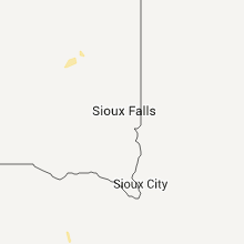


Cities Most Affected by Hail Storms of 6/2/2015
| Hail Size | Demographics of Zip Codes Affected | ||||||
|---|---|---|---|---|---|---|---|
| City | Count | Average | Largest | Pop Density | House Value | Income | Age |
| Pingree, ND | 2 | 2.63 | 3.00 | 1 | $20k | $40.7k | 48.1 |
| Glen Ullin, ND | 2 | 1.88 | 2.00 | 1 | $34k | $28.6k | 51.0 |
| Rapid City, SD | 2 | 1.75 | 1.75 | 111 | $119k | $47.4k | 44.3 |
| Bayard, NE | 1 | 2.50 | 2.50 | 5 | $52k | $30.8k | 43.5 |
| Lamoure, ND | 1 | 2.25 | 2.25 | 5 | $40k | $32.3k | 44.8 |
| Fullerton, ND | 1 | 2.25 | 2.25 | 2 | $38k | $29.6k | 43.4 |
| Brooks, MN | 1 | 2.00 | 2.00 | 4 | $29k | $31.0k | 46.0 |
| Merriman, NE | 1 | 1.75 | 1.75 | 0 | $30k | $26.6k | 47.3 |
| Cannon Ball, ND | 1 | 1.75 | 1.75 | 2 | $25k | $19.3k | 22.0 |
| Solen, ND | 1 | 1.75 | 1.75 | 1 | $32k | $35.9k | 41.4 |
| Rushville, NE | 1 | 1.75 | 1.75 | 1 | $43k | $28.7k | 42.9 |
| Linton, ND | 1 | 1.75 | 1.75 | 2 | $43k | $26.4k | 50.6 |
| Kaycee, WY | 1 | 1.75 | 1.75 | 0 | $67k | $35.9k | 44.4 |
Hail and Wind Damage Spotted on 6/2/2015
Filter by Report Type:Hail ReportsWind Reports
States Impacted
North Dakota, South Carolina, North Carolina, Tennessee, Georgia, Florida, South Dakota, Nebraska, Wyoming, MinnesotaNorth Dakota
| Local Time | Report Details |
|---|---|
| 8:54 AM MDT | Thunderstorm wind gust in mercer county ND, 68 miles WNW of Bismarck, ND |
| 2:46 PM CDT | Quarter sized hail reported near Cannon Ball, ND, 37.6 miles S of Bismarck, ND, hail lasted around 10 minutes and heavy rain also reported |
| 2:30 PM MDT | Half Dollar sized hail reported near Taylor, ND, 81.5 miles W of Bismarck, ND, hail lasted about 5 minutes |
| 4:05 PM CDT | Quarter sized hail reported near Strasburg, ND, 55.2 miles SSE of Bismarck, ND, hail up to quarter size lasted 5 minutes. |
| 4:07 PM CDT | Quarter sized hail reported near Strasburg, ND, 54.1 miles SSE of Bismarck, ND |
| 4:25 PM CDT | Half Dollar sized hail reported near Hebron, ND, 60.6 miles W of Bismarck, ND, reported via social media |
| 4:39 PM CDT | Quarter sized hail reported near Hebron, ND, 55.4 miles W of Bismarck, ND |
| 4:45 PM CDT | Golf Ball sized hail reported near Glen Ullin, ND, 49.9 miles W of Bismarck, ND, hailing at time of observation |
| 4:45 PM CDT | Hen Egg sized hail reported near Glen Ullin, ND, 49.9 miles W of Bismarck, ND |
| 5:12 PM CDT | Half Dollar sized hail reported near Almont, ND, 34.6 miles W of Bismarck, ND, hail lasted 10 minutes. |
| 6:10 PM CDT | Ping Pong Ball sized hail reported near Solen, ND, 22.5 miles SSW of Bismarck, ND, hail lasted 5 minutes |
| 6:42 PM CDT | Golf Ball sized hail reported near Solen, ND, 28.7 miles S of Bismarck, ND, hailing at time of observation. |
| 7:00 PM CDT | Golf Ball sized hail reported near Linton, ND, 36.1 miles SSE of Bismarck, ND, hail lasted 15 minutes. |
| 7:00 PM CDT | Golf Ball sized hail reported near Cannon Ball, ND, 37.6 miles S of Bismarck, ND, hail lasted for 10 minutes |
| 7:05 PM CDT | Tea Cup sized hail reported near Pingree, ND, 66.3 miles S of Devils Lake, ND, passed on through social media |
| 7:10 PM CDT | Hen Egg sized hail reported near Pingree, ND, 65.8 miles S of Devils Lake, ND |
| 7:25 PM CDT | Half Dollar sized hail reported near Fullerton, ND, 56.8 miles N of Aberdeen, SD, hailing at time of observation |
| 7:30 PM CDT | Hen Egg sized hail reported near Fullerton, ND, 56.8 miles N of Aberdeen, SD |
| 7:47 PM CDT | Hen Egg sized hail reported near Lamoure, ND, 62.4 miles N of Aberdeen, SD, report passed on via social media |
| 7:51 PM CDT | Quarter sized hail reported near Lamoure, ND, 62.9 miles N of Aberdeen, SD, hailing at time of observation |
South Carolina
| Local Time | Report Details |
|---|---|
| 2:15 PM EDT | Tree down on house with power lines down. another tree down at springs and hill st. from york county s in york county SC, 15.8 miles SSW of Charlotte, NC |
| 4:35 PM EDT | Law enforcement called in with trees down near mile marker 2 on interstate 9 in jasper county SC, 11.8 miles N of Savannah, GA |
| 5:45 PM EDT | Quarter sized hail reported near Wellford, SC, 30.8 miles ENE of Greenville, SC |
| 6:00 PM EDT | Wind caused roof damage to 6 businesses at a walmart anchored shopping center in boiling spring in spartanburg county SC, 37.8 miles ENE of Greenville, SC |
North Carolina
| Local Time | Report Details |
|---|---|
| 2:31 PM EDT | 2 trees down along rugby roa in henderson county NC, 40.3 miles N of Greenville, SC |
| 2:42 PM EDT | At least 2 power lines down in the area as storm passed over. a spotter nearby reported very strong wind that blew down lots of small limbs and twig in mecklenburg county NC, 9.2 miles S of Charlotte, NC |
| 4:55 PM EDT | Trees down around candor... time estimated by radar in montgomery county NC, 62.2 miles E of Charlotte, NC |
| 6:11 PM EDT | Quarter sized hail reported near Stony Point, NC, 39.7 miles NNW of Charlotte, NC |
| 6:35 PM EDT | Trees down at cameron hill rd. and hillmon grove r in harnett county NC, 46.6 miles SW of Raleigh, NC |
| 6:50 PM EDT | Trees down on nursery road in harnett county NC, 43.8 miles SSW of Raleigh, NC |
| 7:20 PM EDT | Many trees down in mocksville with a few on house in davie county NC, 49.3 miles NNE of Charlotte, NC |
| 7:35 PM EDT | One tree fell on power lines along cornatzer road. they had a little pea sized hail but it was very brie in davie county NC, 52.8 miles NNE of Charlotte, NC |
| 7:49 PM EDT | Tree down on puritan lane... time estimated by radar in forsyth county NC, 61.8 miles NNE of Charlotte, NC |
| 7:50 PM EDT | Three trees down on hampton rd. near old byerly r in davidson county NC, 57.5 miles NNE of Charlotte, NC |
| 8:25 PM EDT | Trees down on fox meadow l in forsyth county NC, 67.1 miles NNE of Charlotte, NC |
| 9:27 PM EDT | Tree down on east academy street... time estimated by radar in randolph county NC, 65 miles W of Raleigh, NC |
Tennessee
| Local Time | Report Details |
|---|---|
| 3:00 PM EDT | Quarter sized hail reported near Georgetown, TN, 26 miles NE of Chattanooga, TN, nickel to quarter sized hail reported by public at georgetown post office. hail was large enough to damage vehicles. |
| 5:10 PM EDT | Quarter sized hail reported near Sevierville, TN, 20.1 miles SE of Knoxville, TN |
| 5:36 PM EDT | Quarter sized hail reported near Walland, TN, 16.9 miles SSE of Knoxville, TN |
| 5:38 PM EDT | Quarter sized hail reported near Pigeon Forge, TN, 23.4 miles ESE of Knoxville, TN |
| 5:45 PM EDT | Ping Pong Ball sized hail reported near Gatlinburg, TN, 29.3 miles SE of Knoxville, TN |
| 5:45 PM EDT | Trees knocked down from convective thunderstorm downburst winds in gatlinbur in sevier county TN, 29.3 miles SE of Knoxville, TN |
| 6:25 PM EDT | Ping Pong Ball sized hail reported near Gatlinburg, TN, 29.3 miles SE of Knoxville, TN |
Georgia
| Local Time | Report Details |
|---|---|
| 4:00 PM EDT | Quarter sized hail reported near Savannah, GA, 9.2 miles WSW of Savannah, GA |
| 4:04 PM EDT | Very large tree blown down at the entrance to the southbridge neighborhood. tree blocking the road. time estimated based on rada in chatham county GA, 9 miles WSW of Savannah, GA |
| 5:03 PM EDT | Quarter sized hail reported near Chatsworth, GA, 33.3 miles ESE of Chattanooga, TN, dime to quarter sized hail fell for about 5 minutes at bp gas station. cars pulled in under the awning. |
Florida
| Local Time | Report Details |
|---|---|
| 4:35 PM EDT | Metal roof blown off structure. vehicle damaged by fallen tree. power pole blown down. 2 light poles blown dow in clay county FL, 16.3 miles SSW of Jacksonville, FL |
South Dakota
| Local Time | Report Details |
|---|---|
| 4:30 PM MDT | Half Dollar sized hail reported near Rapid City, SD, 6.8 miles SW of Rapid City, SD |
| 4:30 PM MDT | Golf Ball sized hail reported near Rapid City, SD, 6.8 miles SW of Rapid City, SD |
| 4:32 PM MDT | Golf Ball sized hail reported near Rapid City, SD, 7.7 miles SW of Rapid City, SD |
| 4:36 PM MDT | Quarter sized hail reported near Rapid City, SD, 4.2 miles S of Rapid City, SD |
| 7:15 PM MDT | Storm damage reported in bennett county SD, 62.2 miles WNW of Valentine, NE |
| 7:15 PM MDT | Storm damage reported in bennett county SD, 63.8 miles WNW of Valentine, NE |
| 9:00 PM CDT | Storm damage reported in todd county SD, 42.9 miles NW of Valentine, NE |
| 10:08 PM MDT | Storm damage reported in pennington county SD, 1.3 miles SE of Rapid City, SD |
| 10:50 PM MDT | Storm damage reported in pennington county SD, 36.4 miles E of Rapid City, SD |
| 10:50 PM MDT | Storm damage reported in pennington county SD, 36.4 miles E of Rapid City, SD |
| 11:53 PM MDT | Storm damage reported in haakon county SD, 65.9 miles WSW of Pierre, SD |
| 12:30 AM MDT | Storm damage reported in jackson county SD, 49.4 miles SW of Pierre, SD |
| 12:30 AM MDT | Storm damage reported in haakon county SD, 44 miles WSW of Pierre, SD |
Nebraska
| Local Time | Report Details |
|---|---|
| 4:39 PM MDT | Storm damage reported in dawes county NE, 58.6 miles NNE of Scottsbluff, NE |
| 5:35 PM MDT | 60+ mph winds. lost power. power still ou in dawes county NE, 53 miles NE of Scottsbluff, NE |
| 5:35 PM MDT | Golf Ball sized hail reported near Rushville, NE, 85.1 miles NE of Scottsbluff, NE |
| 5:50 PM MDT | Golf Ball sized hail reported near Merriman, NE, 58.3 miles W of Valentine, NE |
| 5:55 PM MDT | Ping Pong Ball sized hail reported near Rushville, NE, 84.6 miles NE of Scottsbluff, NE, relayed via social media |
| 6:20 PM MDT | Quarter sized hail reported near Minatare, NE, 9.1 miles ESE of Scottsbluff, NE |
| 6:35 PM MDT | Tennis Ball sized hail reported near Bayard, NE, 18.2 miles ESE of Scottsbluff, NE, large hail reported north of bayard at this moment. |
| 7:25 PM MDT | Quarter sized hail reported near Ashby, NE, 87.2 miles SW of Valentine, NE |
| 7:38 PM MDT | Quarter sized hail reported near Hyannis, NE, 82.1 miles SW of Valentine, NE |
| 7:50 PM MDT | Storm damage reported in cherry county NE, 75.5 miles SW of Valentine, NE |
| 8:18 PM MDT | Storm damage reported in grant county NE, 73.1 miles NNW of North Platte, NE |
| 8:19 PM MDT | Storm damage reported in grant county NE, 72.6 miles NNW of North Platte, NE |
| 8:28 PM MDT | Quarter sized hail reported near Hyannis, NE, 64.2 miles NW of North Platte, NE |
| 9:36 PM CDT | Storm damage reported in cherry county NE, 0.3 miles S of Valentine, NE |
| 8:41 PM MDT | Quarter sized hail reported near Hyannis, NE, 66 miles NW of North Platte, NE |
| 9:18 PM MDT | Quarter sized hail reported near Arthur, NE, 56.1 miles NW of North Platte, NE |
Wyoming
| Local Time | Report Details |
|---|---|
| 5:50 PM MDT | Quarter sized hail reported near Kaycee, WY, 58.8 miles N of Casper, WY |
| 5:50 PM MDT | Ping Pong Ball sized hail reported near Kaycee, WY, 61.4 miles NNW of Casper, WY |
| 6:01 PM MDT | Ping Pong Ball sized hail reported near Kaycee, WY, 61.4 miles NNW of Casper, WY, reported hail slightly smaller than golf ball. also posted picture to facebook. |
| 6:01 PM MDT | Golf Ball sized hail reported near Kaycee, WY, 58.4 miles N of Casper, WY |
| 7:35 PM MDT | Storm damage reported in campbell county WY, 26 miles NNE of Gillette, WY |
| 8:25 PM MDT | 62 mph wind gusts from 825 to 830 p in crook county WY, 43.4 miles E of Gillette, WY |
Minnesota
| Local Time | Report Details |
|---|---|
| 9:45 PM CDT | Quarter sized hail reported near Perley, MN, 21 miles N of Fargo, ND, via social media |
| 10:30 PM CDT | Hen Egg sized hail reported near Brooks, MN, 57.5 miles WNW of Bemidji, MN, relayed via social media |
| 10:40 PM CDT | Ping Pong Ball sized hail reported near Oklee, MN, 54.4 miles NW of Bemidji, MN, relayed via social media |
Connect with Interactive Hail Maps