

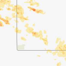
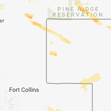
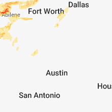
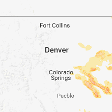
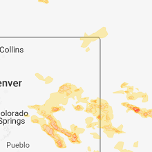
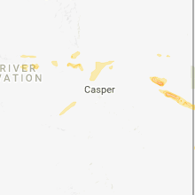
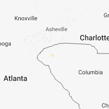
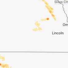
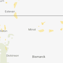
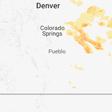
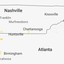
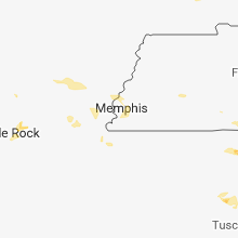
Hail Map for Saturday, June 23, 2018

Number of Impacted Households on 6/23/2018
0
Impacted by 1" or Larger Hail
0
Impacted by 1.75" or Larger Hail
0
Impacted by 2.5" or Larger Hail
Square Miles of Populated Area Impacted on 6/23/2018
0
Impacted by 1" or Larger Hail
0
Impacted by 1.75" or Larger Hail
0
Impacted by 2.5" or Larger Hail

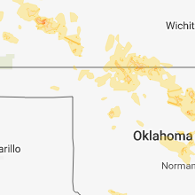


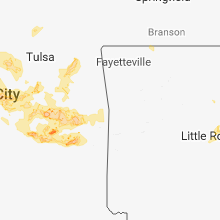
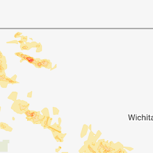

Cities Most Affected by Hail Storms of 6/23/2018
| Hail Size | Demographics of Zip Codes Affected | ||||||
|---|---|---|---|---|---|---|---|
| City | Count | Average | Largest | Pop Density | House Value | Income | Age |
| Colorado City, TX | 4 | 2.38 | 2.75 | 10 | $33k | $25.5k | 35.0 |
| Colby, KS | 3 | 1.83 | 2.00 | 13 | $79k | $37.3k | 35.7 |
| Frederick, OK | 2 | 1.88 | 2.00 | 13 | $28k | $23.3k | 39.5 |
| Ulysses, KS | 1 | 2.75 | 2.75 | 11 | $79k | $39.7k | 32.8 |
| Tipton, OK | 1 | 2.00 | 2.00 | 3 | $34k | $25.2k | 43.0 |
| Chouteau, OK | 1 | 2.00 | 2.00 | 40 | $66k | $30.4k | 40.3 |
| Grainfield, KS | 1 | 1.75 | 1.75 | 1 | $38k | $32.4k | 46.6 |
| Kit Carson, CO | 1 | 1.75 | 1.75 | 0 | $45k | $28.1k | 42.2 |
| Hoskins, NE | 1 | 1.75 | 1.75 | 8 | $72k | $34.3k | 39.2 |
| Weskan, KS | 1 | 1.75 | 1.75 | 1 | $52k | $32.9k | 34.3 |
| Randolph, NE | 1 | 1.75 | 1.75 | 7 | $47k | $30.8k | 46.4 |
| Roscoe, TX | 1 | 1.75 | 1.75 | 3 | $35k | $26.2k | 40.1 |
| Lexington, NE | 1 | 1.75 | 1.75 | 46 | $64k | $38.3k | 30.8 |
| Holliday, TX | 1 | 1.75 | 1.75 | 3 | $52k | $34.3k | 43.3 |
| Loraine, TX | 1 | 1.75 | 1.75 | 5 | $23k | $22.6k | 41.0 |
| Rotan, TX | 1 | 1.75 | 1.75 | 5 | $31k | $24.2k | 45.7 |
| Stratton, CO | 1 | 1.75 | 1.75 | 2 | $77k | $35.0k | 37.2 |
Hail and Wind Damage Spotted on 6/23/2018
Filter by Report Type:Hail ReportsWind Reports
States Impacted
Tennessee, Mississippi, Alabama, Kansas, Georgia, South Carolina, Virginia, Idaho, North Carolina, Colorado, Wyoming, Nebraska, Maryland, Texas, Oklahoma, Illinois, South DakotaTennessee
| Local Time | Report Details |
|---|---|
| 8:07 AM CDT | Picture on social media of large trees uprooted and a power pole snapped in whitehaven. time of event is radar estimate in shelby county TN, 9 miles S of Memphis, TN |
| 8:13 AM CDT | The integrated terminal weather system at the memphis international airport reported a wind gust of 65 mp in shelby county TN, 8.2 miles SSE of Memphis, TN |
| 8:15 AM CDT | Multiple fallen trees reported by law enforcement in germantown. time of event is radar estimate in shelby county TN, 15.2 miles ESE of Memphis, TN |
| 8:30 AM CDT | Picture on social media of multiple trees down in collierville. time of event is radar estimate in shelby county TN, 21.8 miles ESE of Memphis, TN |
| 10:42 AM CDT | Report of several trees down in colinwood on 7th avenue. time is estimated via rada in wayne county TN, 26.4 miles N of Florence, AL |
| 10:54 AM CDT | Trees down in iron city and st. joseph. time is estimated from rada in lawrence county TN, 16.7 miles NNE of Florence, AL |
| 10:54 AM CDT | Trees and powerlines down at st. joseph's trailer park on us-4 in lawrence county TN, 18.4 miles NNE of Florence, AL |
| 11:00 AM CDT | Several reports of trees down in loretto. in and around union hill road. also power outages being reported in lorett in lawrence county TN, 23.4 miles NE of Florence, AL |
| 11:06 AM CDT | Report of a person trapped in a structure due to down trees on johnson lake roa in lawrence county TN, 25.5 miles NE of Florence, AL |
| 11:14 AM CDT | Several large trees down in the minor hill area. time is estimated via rada in giles county TN, 33.1 miles ENE of Florence, AL |
| 12:50 PM CDT | Widespread wind damage to trees across the count in marion county TN, 18.2 miles W of Chattanooga, TN |
| 2:12 PM EDT | Trees down on a few houses in a small area on maplewood drive. possible microburs in hamilton county TN, 11.6 miles ESE of Chattanooga, TN |
| 2:15 PM EDT | A few trees were down across the count in hamilton county TN, 3.2 miles ENE of Chattanooga, TN |
| 1:15 PM CDT | Downed trees blocking roadways at four places across the count in sequatchie county TN, 22.8 miles NNW of Chattanooga, TN |
| 2:40 PM EDT | Numerous trees down...some damaging structures... some blocking road in bradley county TN, 26.5 miles ENE of Chattanooga, TN |
| 3:05 PM EDT | Several trees down around the are in mcminn county TN, 41.4 miles NE of Chattanooga, TN |
| 3:15 PM EDT | Trees dow in mcminn county TN, 49.1 miles SW of Knoxville, TN |
| 3:15 PM EDT | Trees dow in monroe county TN, 46 miles SSW of Knoxville, TN |
Mississippi
| Local Time | Report Details |
|---|---|
| 8:30 AM CDT | Large tree limbs down just south of collierville. time of event is radar estimate in marshall county MS, 24 miles ESE of Memphis, TN |
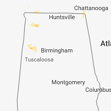
Alabama
| Local Time | Report Details |
|---|---|
| 8:58 AM CDT | 2 trees uprooted (one took down the other) along virginia drive in hueytown. time estimated from rada in jefferson county AL, 14.4 miles WSW of Birmingham, AL |
| 10:33 AM CDT | Trees and power lines down near the 4500 block on highway 15 in lauderdale county AL, 5.5 miles N of Florence, AL |
| 11:04 AM CDT | Large tree down across nuclear plant roa in limestone county AL, 37.1 miles E of Florence, AL |
| 5:34 PM CDT | Tree down along blue rd near littlevill in colbert county AL, 11.2 miles S of Florence, AL |
| 5:35 PM CDT | Half Dollar sized hail reported near Tuscumbia, AL, 12.6 miles S of Florence, AL, half-dollar sized hail... covering the yard near the corner of huckleberry hills lane and douglas road. |
| 5:40 PM CDT | Quarter sized hail reported near Tuscumbia, AL, 15.3 miles S of Florence, AL, quarter-sized hail along the colbert/franklin county line. location approximate. |
| 7:35 PM CDT | Couple trees down near the crossville area. time estimated from rada in lamar county AL, 52.4 miles ENE of Starkville, MS |
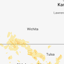
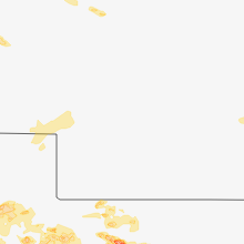
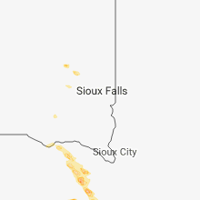
Kansas
| Local Time | Report Details |
|---|---|
| 10:58 AM CDT | Winds were estimated from 65 to 70 mp in ford county KS, 46.8 miles ESE of Garden City, KS |
| 3:26 PM CDT | Hen Egg sized hail reported near Colby, KS, 0.6 miles SSW of Colby, KS, relayed via social media. |
| 3:30 PM CDT | Half Dollar sized hail reported near Colby, KS, 0.6 miles SSW of Colby, KS, relayed via social media. |
| 3:30 PM CDT | Golf Ball sized hail reported near Colby, KS, 8.5 miles WSW of Colby, KS, relayed via social media. |
| 3:35 PM CDT | Quarter sized hail reported near Colby, KS, 0.8 miles ENE of Colby, KS, relayed via social media. |
| 4:04 PM CDT | Golf Ball sized hail reported near Colby, KS, 9 miles SE of Colby, KS, at least golf ball size hail. hard to tell largest size because some of stones breaking as they hit. |
| 4:34 PM CDT | Half Dollar sized hail reported near Oakley, KS, 13.2 miles SE of Colby, KS |
| 4:39 PM CDT | Quarter sized hail reported near Atwood, KS, 28.5 miles N of Colby, KS |
| 5:15 PM CDT | Quarter sized hail reported near Grinnell, KS, 23.1 miles ESE of Colby, KS, pea to quarter size hail fell for roughly 5 minutes. ground covered. |
| 5:36 PM CDT | Quarter sized hail reported near Atwood, KS, 36.7 miles NNW of Colby, KS |
| 5:36 PM CDT | Quarter sized hail reported near Garden City, KS, 8.8 miles ESE of Garden City, KS |
| 6:00 PM CDT | Golf Ball sized hail reported near Grainfield, KS, 30 miles ESE of Colby, KS, time estimated. |
| 6:04 PM MDT | Mesonet station c6099... 9 sse sharon spring in wallace county KS, 55.1 miles SW of Colby, KS |
| 9:40 PM CDT | Mesonet station e1393... 3 sse dighto in lane county KS, 39.2 miles NE of Garden City, KS |
| 10:39 PM CDT | Storm damage reported in ford county KS, 47.9 miles ESE of Garden City, KS |
| 10:55 PM CDT | Baseball sized hail reported near Ulysses, KS, 44 miles SW of Garden City, KS |
| 10:57 PM CDT | Asos station ddc... dodge city regional airpor in ford county KS, 51.2 miles ESE of Garden City, KS |
| 10:58 PM CDT | Corrects previous tstm wnd gst report from 2 wnw dodge city. winds were estimated from 65 to 70 mp in ford county KS, 46.8 miles ESE of Garden City, KS |
| 11:05 PM CDT | Asos station ddc... dodge city regional airpor in ford county KS, 51.2 miles ESE of Garden City, KS |
| 11:50 PM MDT | Golf Ball sized hail reported near Weskan, KS, 61.6 miles SW of Colby, KS, quarter to golf ball size hail. the duration of the hail event was 20 minutes. |
| 1:16 AM CDT | Asos station p28... medicine lodge asos sit in barber county KS, 72.4 miles WSW of Wichita, KS |
| 1:08 AM MDT | Quarter sized hail reported near Weskan, KS, 56.7 miles WSW of Colby, KS, pea to quarter size hail. |
| 1:21 AM MDT | Quarter sized hail reported near Goodland, KS, 37.1 miles W of Colby, KS |
| 1:27 AM MDT | Quarter sized hail reported near Goodland, KS, 36.4 miles WSW of Colby, KS, nickel to quarter size hail. |
| 5:25 AM CDT | Quarter sized hail reported near Garden City, KS, 2.5 miles NNE of Garden City, KS |
Georgia
| Local Time | Report Details |
|---|---|
| 1:48 PM EDT | 911 call center reporting caller counted approx 6 trees down along burkhalter gap r in dade county GA, 13.8 miles SW of Chattanooga, TN |
| 1:48 PM EDT | Ga 511 reporting a tree down on sunset rd blocking all lanes of traffic... near ga 13 in dade county GA, 18.4 miles SW of Chattanooga, TN |
| 1:48 PM EDT | Trees are down all over dade county... including 3 large trees down along n sunset dr in trenton in dade county GA, 16.7 miles SW of Chattanooga, TN |
| 1:50 PM EDT | Report of a tree down on creek rd in dade county GA, 13.2 miles SW of Chattanooga, TN |
| 2:05 PM EDT | Trees and power lines down at the intersection of alexander bridge rd and lafayette r in catoosa county GA, 7.9 miles SSE of Chattanooga, TN |
| 2:15 PM EDT | Two trees reported down on three notch rd near the intersection with battlefield pkw in catoosa county GA, 11.3 miles SE of Chattanooga, TN |
| 2:16 PM EDT | Tree and power lines reported down at the intersection of lafayette rd and logan r in whitfield county GA, 23.1 miles SSE of Chattanooga, TN |
| 2:18 PM EDT | Tree and power lines reported down at the intersection of crow valley rd and ashtod woods wa in whitfield county GA, 24.4 miles SE of Chattanooga, TN |
| 2:20 PM EDT | Tree and power lines reported down at the intersection of suffolk way and palomino d in whitfield county GA, 21.6 miles ESE of Chattanooga, TN |
| 2:34 PM EDT | Large tree reported down at the intersection of stinsonville rd and captain kell d in bibb county GA, 73.5 miles SE of Atlanta, GA |
| 3:11 PM EDT | Multiple trees and power lines reported down on maxwell rd in the cherry log creek area. winds estimated at 60 mp in gilmer county GA, 55.9 miles ESE of Chattanooga, TN |
| 3:35 PM EDT | Multiple trees reported down in the vogel state park area along hwy 12 in union county GA, 75.2 miles W of Greenville, SC |
| 3:45 PM EDT | Tree reported down at the intersection of hwy 129 and nottely dam r in union county GA, 69.4 miles S of Knoxville, TN |
| 3:45 PM EDT | Small dock on lake chatuge in hiawassee was lifted into the air and flipped ove in towns county GA, 66.4 miles W of Greenville, SC |
| 3:50 PM EDT | Reports via social media of the storm flipping a small dock on lake chatuge in hiawasse in towns county GA, 66.4 miles W of Greenville, SC |
| 4:15 PM EDT | County officials report numerous trees and power lines down across the count in rabun county GA, 45.6 miles W of Greenville, SC |
South Carolina
| Local Time | Report Details |
|---|---|
| 2:40 PM EDT | Numerous trees down...some damaging structures... some blocking road in greenville county SC, 17 miles NNE of Greenville, SC |
| 3:18 PM EDT | Tree down in roadway on old sudlow lake road near the intersection of richland road. time estimated based on rada in aiken county SC, 5.1 miles NE of Augusta, GA |
| 4:32 PM EDT | Tree down in ridge spring. local utility company reporting approximately 180 customers without powe in saluda county SC, 31.4 miles NE of Augusta, GA |
| 4:40 PM EDT | Numerous trees and power lines blown down between walhalla and sale in oconee county SC, 22 miles W of Greenville, SC |
| 5:10 PM EDT | County reports numerous trees and power lines blown down across the eastern half of the count in pickens county SC, 2.3 miles NNE of Greenville, SC |
| 5:25 PM EDT | Tree down on a ca in pickens county SC, 16.5 miles N of Greenville, SC |
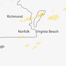
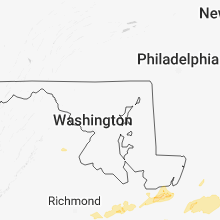
Virginia
| Local Time | Report Details |
|---|---|
| 2:45 PM EDT | Quarter sized hail reported near Deltaville, VA, 57.5 miles NNW of Virginia Beach, VA, report via twitter. |
| 4:11 PM EDT | Mesonet station e9295... 1 wsw chincoteagu in accomack county VA, 32.2 miles SSW of Ocean City, MD |
| 5:09 PM EDT | Tree down at the intersection of rixeyville road and colvin roa in culpeper county VA, 80.5 miles N of Richmond, VA |
| 5:22 PM EDT | Tree down at the 15...000 block of beau ridge driv in prince william county VA, 60.6 miles SW of Baltimore, MD |
| 6:01 PM EDT | Tree down at dumfries road and counselor roa in prince william county VA, 62.4 miles SW of Baltimore, MD |
| 6:03 PM EDT | Tree down at the 13000 block of den hollow court roa in prince william county VA, 62 miles SW of Baltimore, MD |
| 6:05 PM EDT | Tree down at the 13000 block of den hollow court roa in prince william county VA, 62 miles SW of Baltimore, MD |
| 6:22 PM EDT | Tree down at the 15000 block of beau ridge driv in prince william county VA, 60.6 miles SW of Baltimore, MD |
Idaho
| Local Time | Report Details |
|---|---|
| 1:15 PM MDT | Quarter sized hail reported near Idaho Falls, ID, 4.5 miles SW of Idaho Falls, ID, reported via social media - along i-15 5 miles south of idaho falls. |
North Carolina
| Local Time | Report Details |
|---|---|
| 3:27 PM EDT | Numerous reports of downed trees and powerlines around mile marker 4 on us 64 in murph in cherokee county NC, 60.3 miles S of Knoxville, TN |
| 3:30 PM EDT | Numerous trees down across the count in cherokee county NC, 60.3 miles S of Knoxville, TN |
| 3:47 PM EDT | A couple trees blown down across hwy 28 near stecoa in graham county NC, 42.6 miles SSE of Knoxville, TN |
| 3:50 PM EDT | Clay county 911 call center reported numerous trees down across the count in clay county NC, 63 miles S of Knoxville, TN |
| 4:20 PM EDT | Public reports top snapped off of large oak tre in macon county NC, 46.7 miles WNW of Greenville, SC |
| 4:35 PM EDT | County reports widespread trees and power lines blown down from savannah toward cashier in jackson county NC, 46.6 miles NW of Greenville, SC |
| 7:27 PM EDT | Time is radar estimated. tree downed onto power lines at backwoods roa in currituck county NC, 17.3 miles SW of Virginia Beach, VA |
Colorado
| Local Time | Report Details |
|---|---|
| 3:20 PM MDT | Ping Pong Ball sized hail reported near Hugo, CO, 76.9 miles NE of Pueblo, CO |
| 3:43 PM MDT | Half Dollar sized hail reported near Burlington, CO, 59.4 miles SSE of Yuma, CO, relayed via social media. hail covering the ground from pea to half dollar size. |
| 4:15 PM MDT | Golf Ball sized hail reported near Stratton, CO, 56.2 miles S of Yuma, CO, ***update... up the size to golf ball due to reporter sending in pictures with divots that est to be golf ball size*** this corrects previous hail report. facebook repo |
| 4:15 PM MDT | Half Dollar sized hail reported near Stratton, CO, 56.2 miles S of Yuma, CO, facebook report received of measured half dollar hail. the reporter said they just got home about an hour after the storm passed so does not know the actual size the ha |
| 4:20 PM MDT | Ping Pong Ball sized hail reported near Hugo, CO, 78.2 miles ENE of Pueblo, CO |
| 4:22 PM MDT | Ping Pong Ball sized hail reported near Burlington, CO, 64.6 miles SSE of Yuma, CO |
| 5:09 PM MDT | Golf Ball sized hail reported near Kit Carson, CO, 92.3 miles ENE of Pueblo, CO |
| 5:36 PM MDT | Quarter sized hail reported near Hugo, CO, 65.8 miles ENE of Pueblo, CO |
| 5:45 PM MDT | Quarter sized hail reported near Karval, CO, 65.9 miles ENE of Pueblo, CO |
| 6:10 PM MDT | Quarter sized hail reported near Eads, CO, 95.7 miles E of Pueblo, CO |
| 9:00 PM MDT | Storm damage reported in sedgwick county CO, 50 miles NNE of Yuma, CO |
Wyoming
| Local Time | Report Details |
|---|---|
| 4:20 PM MDT | Quarter sized hail reported near Midwest, WY, 38.7 miles N of Casper, WY, nickel to quarter sized hail fell in midwest with accumulations one inch deep. |
Nebraska
| Local Time | Report Details |
|---|---|
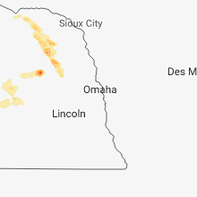
| 5:48 PM CDT | Quarter sized hail reported near Carroll, NE, 75.7 miles E of Oneill, NE, nickel to quarter size hail. |
| 5:58 PM CDT | Quarter sized hail reported near Wayne, NE, 80.1 miles E of Oneill, NE |
| 5:59 PM CDT | Golf Ball sized hail reported near Randolph, NE, 66.7 miles ESE of Oneill, NE |
| 6:00 PM CDT | Golf Ball sized hail reported near Hoskins, NE, 70.5 miles ESE of Oneill, NE |
| 6:10 PM MDT | Quarter sized hail reported near Gering, NE, 0.8 miles S of Scottsbluff, NE |
| 6:10 PM MDT | Quarter sized hail reported near Scottsbluff, NE, 1 miles WNW of Scottsbluff, NE |
| 6:14 PM MDT | Half inch hail along with very heavy rainfall and strong winds. hail lasted til 618 p in scotts bluff county NE, 2 miles WNW of Scottsbluff, NE |
| 7:20 PM CDT | Ping Pong Ball sized hail reported near Howells, NE, 70 miles NW of Omaha, NE |
| 7:28 PM CDT | Half Dollar sized hail reported near Howells, NE, 70 miles NW of Omaha, NE |
| 6:45 PM MDT | 50 to 60 mph wind in morrill county NE, 23.4 miles ESE of Scottsbluff, NE |
| 6:53 PM MDT | 60-65 mph wind gusts in bridgeport. minor tree damage reporte in morrill county NE, 32 miles ESE of Scottsbluff, NE |
| 7:14 PM MDT | Estimated 60 to 70 mph winds north of dalton. power flashes along highway 385 in morrill count in morrill county NE, 45.8 miles SE of Scottsbluff, NE |
| 8:20 PM CDT | Golf Ball sized hail reported near Lexington, NE, 58.5 miles ESE of North Platte, NE |
| 7:30 PM MDT | Lisco1 upr sit in morrill county NE, 55.3 miles ESE of Scottsbluff, NE |
| 9:17 PM MDT | Storm damage reported in keith county NE, 47 miles W of North Platte, NE |
| 9:34 PM MDT | Storm damage reported in keith county NE, 38.8 miles W of North Platte, NE |
Maryland
| Local Time | Report Details |
|---|---|
| 7:45 PM EDT | Several trees down along baptist church roa in st. marys county MD, 59.7 miles S of Baltimore, MD |
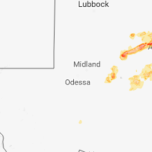
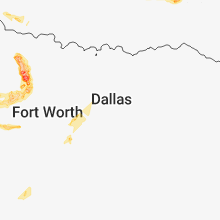
Texas
| Local Time | Report Details |
|---|---|
| 7:25 PM CDT | Golf Ball sized hail reported near Colorado City, TX, 70.9 miles W of Abilene, TX, fm 2836 |
| 7:43 PM CDT | Golf Ball sized hail reported near Loraine, TX, 55.5 miles W of Abilene, TX |
| 7:47 PM CDT | Golf Ball sized hail reported near Roscoe, TX, 46.9 miles W of Abilene, TX |
| 8:16 PM CDT | Baseball sized hail reported near Colorado City, TX, 65.5 miles W of Abilene, TX |
| 8:18 PM CDT | Tennis Ball sized hail reported near Colorado City, TX, 65.5 miles W of Abilene, TX, east 2nd st. |
| 8:20 PM CDT | Tennis Ball sized hail reported near Colorado City, TX, 65.5 miles W of Abilene, TX, east 2nd st. |
| 8:45 PM CDT | Storm damage reported in tom green county TX, 76.4 miles SW of Abilene, TX |
| 8:55 PM CDT | Storm damage reported in tom green county TX, 79.4 miles SW of Abilene, TX |
| 8:56 PM CDT | Golf Ball sized hail reported near Rotan, TX, 63.1 miles WNW of Abilene, TX |
| 9:13 PM CDT | Storm damage reported in tom green county TX, 80.6 miles SSW of Abilene, TX |
| 9:55 PM CDT | Golf Ball sized hail reported near Holliday, TX, 23 miles SW of Wichita Falls, TX |
| 9:57 PM CDT | Quarter sized hail reported near Holliday, TX, 20.8 miles SW of Wichita Falls, TX |
| 11:02 PM CDT | Ping Pong Ball sized hail reported near Olney, TX, 39.4 miles SSW of Wichita Falls, TX, ping pong ball hail near olney |
| 11:05 PM CDT | Storm damage reported in throckmorton county TX, 55.8 miles NE of Abilene, TX |
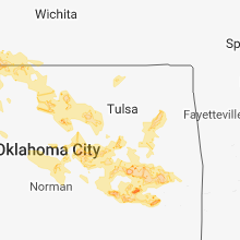
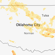
Oklahoma
| Local Time | Report Details |
|---|---|
| 8:10 PM CDT | Ping Pong Ball sized hail reported near Tipton, OK, 55.5 miles NW of Wichita Falls, TX |
| 8:20 PM CDT | Hen Egg sized hail reported near Tipton, OK, 53.1 miles NW of Wichita Falls, TX |
| 8:34 PM CDT | Golf Ball sized hail reported near Frederick, OK, 46.5 miles NNW of Wichita Falls, TX |
| 9:25 PM CDT | Hen Egg sized hail reported near Frederick, OK, 41.1 miles NNW of Wichita Falls, TX |
| 9:30 PM CDT | Half Dollar sized hail reported near Loveland, OK, 36.1 miles NNW of Wichita Falls, TX |
| 11:50 PM CDT | Half Dollar sized hail reported near Okemah, OK, 48.2 miles SSW of Tulsa, OK |
| 1:45 AM CDT | Hen Egg sized hail reported near Chouteau, OK, 38.8 miles E of Tulsa, OK |
| 1:48 AM CDT | Ping Pong Ball sized hail reported near Chouteau, OK, 36.6 miles E of Tulsa, OK, relayed from a viewer in chouteau |
| 1:55 AM CDT | Storm damage reported in woods county OK, 47.4 miles ENE of Woodward, OK |
| 2:45 AM CDT | Powerlines down in garfield county OK, 65.8 miles NNW of Oklahoma City, OK |
| 2:50 AM CDT | Storm damage reported in garfield county OK, 63.5 miles NNW of Oklahoma City, OK |
| 2:50 AM CDT | Storm damage reported in garfield county OK, 63.5 miles NNW of Oklahoma City, OK |
| 2:55 AM CDT | Powerlines down in garfield county OK, 59.1 miles NNW of Oklahoma City, OK |
| 3:05 AM CDT | Storm damage reported in garfield county OK, 66.7 miles N of Oklahoma City, OK |
| 4:11 AM CDT | Half Dollar sized hail reported near Krebs, OK, 44.1 miles NNE of Atoka, OK |
| 5:00 AM CDT | Reported by the oklahoma mesone in okfuskee county OK, 51.7 miles SSW of Tulsa, OK |
| 5:24 AM CDT | Storm damage reported in muskogee county OK, 33.9 miles SE of Tulsa, OK |
| 5:34 AM CDT | Half Dollar sized hail reported near Mcalester, OK, 34.2 miles NNE of Atoka, OK |
| 5:45 AM CDT | Storm damage reported in mcintosh county OK, 52.4 miles SE of Tulsa, OK |
| 5:55 AM CDT | Large tree limbs down. at least 8 inches in diameter. one report near 5th street and washington avenu in pittsburg county OK, 42.7 miles NNE of Atoka, OK |
| 5:56 AM CDT | Storm damage reported in pittsburg county OK, 40 miles NNE of Atoka, OK |
| 6:36 AM CDT | Storm damage reported in sequoyah county OK, 21.1 miles NW of Fort Smith, AR |
Illinois
| Local Time | Report Details |
|---|---|
| 8:30 PM CDT | Large tree limbs down blocking intersection of highway 145 and country club road...in addition to rosebud and commer road in massac county IL, 47.7 miles E of Cape Girardeau, MO |
South Dakota
| Local Time | Report Details |
|---|---|
| 8:30 PM CDT | Half Dollar sized hail reported near Salem, SD, 42.2 miles WNW of Sioux Falls, SD |
Connect with Interactive Hail Maps