

Hail Map for Friday, June 25, 2021

Number of Impacted Households on 6/25/2021
0
Impacted by 1" or Larger Hail
0
Impacted by 1.75" or Larger Hail
0
Impacted by 2.5" or Larger Hail
Square Miles of Populated Area Impacted on 6/25/2021
0
Impacted by 1" or Larger Hail
0
Impacted by 1.75" or Larger Hail
0
Impacted by 2.5" or Larger Hail


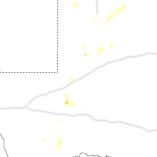


Cities Most Affected by Hail Storms of 6/25/2021
| Hail Size | Demographics of Zip Codes Affected | ||||||
|---|---|---|---|---|---|---|---|
| City | Count | Average | Largest | Pop Density | House Value | Income | Age |
| Campo, CO | 1 | 2.75 | 2.75 | 0 | $22k | $24.6k | 51.3 |
| Hugoton, KS | 1 | 2.75 | 2.75 | 8 | $81k | $43.0k | 34.5 |
| Clarendon, TX | 1 | 2.00 | 2.00 | 1 | $51k | $29.3k | 42.4 |
| Colby, KS | 1 | 1.75 | 1.75 | 13 | $79k | $37.3k | 35.7 |
Hail and Wind Damage Spotted on 6/25/2021
Filter by Report Type:Hail ReportsWind Reports
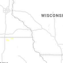
States Impacted
Kansas, Nebraska, Colorado, Texas, Oklahoma, Missouri, Indiana, New Mexico, IllinoisKansas
| Local Time | Report Details |
|---|---|
| 1:00 PM CDT | Viewer called into kake to report two utility poles were down along with several tree limbs of unknown size. time is based on rada in sedgwick county KS, 7.7 miles NE of Wichita, KS |
| 1:51 PM CDT | Storm damage reported in butler county KS, 36.7 miles NE of Wichita, KS |
| 2:25 PM CDT | Dispatch reported a semi roll over. time is estimated from rada in chase county KS, 56.9 miles S of Manhattan, KS |
| 3:27 PM CDT | Delayed report on i-3 in lyon county KS, 55.8 miles NNW of Chanute, KS |
| 3:29 PM CDT | Quarter sized hail reported near , , 42.1 miles WSW of Kansas City, MO, relayed by em. |
| 3:31 PM CDT | 3 inch tree limbs down. radar estimated tim in douglas county KS, 40 miles WSW of Kansas City, MO |
| 3:50 PM CDT | Quarter sized hail reported near Shawnee, KS, 10.5 miles WSW of Kansas City, MO |
| 3:51 PM CDT | Storm damage reported in shawnee county KS, 50.6 miles E of Manhattan, KS |
| 4:03 PM CDT | Quarter sized hail reported near Kansas City, KS, 7.9 miles WSW of Kansas City, MO |
| 4:30 PM CDT | Tree limb down in ottawa. time estimated from radar. relayed from sheriff offic in franklin county KS, 51.2 miles SW of Kansas City, MO |
| 4:54 PM CDT | Quarter sized hail reported near Elkhart, KS, 81.4 miles SW of Garden City, KS, quarter size hail reported. |
| 4:55 PM CDT | Mesonet station cw8810 elkhar in morton county KS, 88 miles SW of Garden City, KS |
| 5:00 PM CDT | A few stop signs blown down... 1 to 2 inch diameter branches blown down. street flooding between hillsboro and goesse in marion county KS, 38.8 miles N of Wichita, KS |
| 5:01 PM CDT | Quarter sized hail reported near Elkhart, KS, 81.4 miles SW of Garden City, KS, corrects previous hail report from 3 s wilburton. quarter size hail reported. |
| 5:30 PM CDT | Quarter sized hail reported near Elkhart, KS, 87.7 miles SW of Garden City, KS, quarter size hail reported near the state line. |
| 5:36 PM CDT | 8 inch diameter tree limbs down and 40-foot tall tree down. street signs blown ove in harvey county KS, 32.3 miles N of Wichita, KS |
| 5:40 PM CDT | Baseball sized hail reported near Hugoton, KS, 71.7 miles SSW of Garden City, KS, baseball size hail reported... damage to tractor windows in the field. |
| 5:58 PM CDT | 70 mph wind gust reporte in comanche county KS, 63.1 miles N of Woodward, OK |
| 6:05 PM CDT | Storm damage reported in franklin county KS, 52.8 miles N of Chanute, KS |
| 6:15 PM CDT | Awos station khqg hugoto in stevens county KS, 61.5 miles SSW of Garden City, KS |
| 6:20 PM CDT | Ping Pong Ball sized hail reported near Haviland, KS, 76.9 miles N of Woodward, OK, ping pong ball size hail and gusty winds reported. |
| 6:23 PM CDT | Occasional gusts up to 60 mph. report was 2 miles e of k-15 on the marion/harvey co. lin in marion county KS, 34.9 miles NNE of Wichita, KS |
| 6:28 PM CDT | Asos station kp28 medicine lodg in barber county KS, 72.4 miles WSW of Wichita, KS |
| 6:30 PM CDT | 60 mph wind gusts reported by e in pratt county KS, 85.8 miles NNE of Woodward, OK |
| 6:30 PM CDT | Report of gas lines torn and school roof blown of in seward county KS, 64.2 miles S of Garden City, KS |
| 6:32 PM CDT | Social media repor in meade county KS, 60.2 miles SSE of Garden City, KS |
| 6:33 PM CDT | Spotter estimates 50 to 60 mph wind gusts. no damage reporte in cheyenne county KS, 36 miles WNW of Colby, KS |
| 6:36 PM CDT | 3 inch limbs dow in seward county KS, 64.2 miles S of Garden City, KS |
| 6:39 PM CDT | Quarter sized hail reported near Newton, KS, 35.4 miles N of Wichita, KS, intersection of k-15 and 90th. |
| 6:40 PM CDT | Mesonet station up407 0.6 sw hayne (upr in seward county KS, 60 miles S of Garden City, KS |
| 6:42 PM CDT | Corrects previous tstm wnd gst report from meade state park. social media repor in meade county KS, 60.2 miles SSE of Garden City, KS |
| 6:45 PM CDT | Quarter sized hail reported near Liberal, KS, 64.2 miles S of Garden City, KS, quarter size hail... winds over 60 mph... and power out on social media. |
| 6:54 PM CDT | Roof torn off machine she in harvey county KS, 28.6 miles N of Wichita, KS |
| 6:55 PM CDT | Tree fell down in newton on residenc in harvey county KS, 25 miles N of Wichita, KS |
| 7:10 PM CDT | Mesonet station up313 2.1 w minneola (upr in clark county KS, 58.5 miles SE of Garden City, KS |
| 7:11 PM CDT | Storm damage reported in kingman county KS, 42.5 miles W of Wichita, KS |
| 7:14 PM CDT | Multiple power poles dow in harvey county KS, 24.5 miles N of Wichita, KS |
| 7:14 PM CDT | Storm damage reported in harvey county KS, 26.5 miles N of Wichita, KS |
| 7:15 PM CDT | Golf Ball sized hail reported near Colby, KS, 13.3 miles N of Colby, KS, delayed report from public or storm spotter. |
| 7:15 PM CDT | Wind was described as at least 60 mp in rawlins county KS, 13.3 miles N of Colby, KS |
| 7:15 PM CDT | Delayed report. roofs blown off sheds... large trees down... and power lines down. sporadic reports of this kind of damage across kingman count in kingman county KS, 42 miles W of Wichita, KS |
| 7:17 PM CDT | Spotter reported gusts of at least 60 mp in kingman county KS, 43.6 miles W of Wichita, KS |
| 7:22 PM CDT | Quarter sized hail reported near Minneola, KS, 58.5 miles SE of Garden City, KS, quarter inch reported on highway. |
| 7:30 PM CDT | A cargo van box that had been on the ground for a few years blew over just north of sylvia. a 12 inch diameter tree limb broke just north of the city as well. multiple in reno county KS, 61.7 miles WNW of Wichita, KS |
| 7:30 PM CDT | Multiple powerlines down. multiple trees down and uprooted. local street flooding. multiple railroad crossbars broken off at crossings. this damage occurred near newton in harvey county KS, 29.3 miles N of Wichita, KS |
| 7:39 PM CDT | Extensive tree damage in downtown newton. multiple trees on home in harvey county KS, 25 miles N of Wichita, KS |
| 7:39 PM CDT | Measured at the newton airpor in harvey county KS, 25.9 miles N of Wichita, KS |
| 7:39 PM CDT | Multiple buildings with lost siding. multiple trees fallen on vehicle in harvey county KS, 25.7 miles N of Wichita, KS |
| 7:39 PM CDT | Delayed report. partial roof removal of newton school district bus bar in harvey county KS, 24.3 miles N of Wichita, KS |
| 7:40 PM CDT | Report via twitte in sedgwick county KS, 24.1 miles W of Wichita, KS |
| 8:00 PM CDT | City without powe in reno county KS, 28.4 miles WNW of Wichita, KS |
| 8:00 PM CDT | *** 1 inj *** delayed report. spotter relayed report of severe damage to a mobile home and a couple of cars... including a possible injury. time estimated based on rada in reno county KS, 23.3 miles WNW of Wichita, KS |
| 8:04 PM CDT | Storm damage reported in sheridan county KS, 25.9 miles ENE of Colby, KS |
| 8:05 PM CDT | Measured on home weather statio in sedgwick county KS, 6.7 miles NNW of Wichita, KS |
| 8:12 PM CDT | Frequent gusts of 58 to 65 mph occurring at this tim in mcpherson county KS, 49.1 miles NNW of Wichita, KS |
| 8:53 PM CDT | Report replayed via kwch meteorologis in butler county KS, 12.5 miles ENE of Wichita, KS |
| 8:55 PM CDT | Emergency manager reported 60 mph winds with power outages in the city of bento in butler county KS, 14.6 miles ENE of Wichita, KS |
| 9:17 PM CDT | 61 mph wind gust measured at the salina airpor in saline county KS, 64.4 miles WSW of Manhattan, KS |
| 9:18 PM CDT | Storm damage reported in mcpherson county KS, 63.9 miles NNW of Wichita, KS |
| 9:34 PM CDT | Storm damage reported in dickinson county KS, 51.7 miles SW of Manhattan, KS |
| 9:36 PM CDT | Quarter sized hail reported near Plainville, KS, 24.1 miles N of Hays, KS, report from twitter. |
| 10:03 PM CDT | Delayed report. large tree down blocking hwy 160 near ne 40th. time estimated based on rada in harper county KS, 44.8 miles SW of Wichita, KS |
| 10:47 PM CDT | Personal weather statio in mitchell county KS, 62.7 miles ENE of Hays, KS |
Nebraska
| Local Time | Report Details |
|---|---|
| 2:55 PM CDT | Half Dollar sized hail reported near Trenton, NE, 55.6 miles N of Colby, KS, quarter to half dollar size hail reported. possible crop damage also reported. |
| 3:41 PM CDT | Quarter sized hail reported near Mc Cook, NE, 57.3 miles NNE of Colby, KS, hail ranged from half inch to quarter in size. |
| 4:11 PM CDT | Quarter sized hail reported near Hazard, NE, 39.8 miles WNW of Grand Island, NE, spotter network report. time estimated from radar. |
| 5:50 PM CDT | Storm damage reported in garfield county NE, 44.9 miles SSW of Oneill, NE |
| 7:28 PM CDT | Report from mping: 1-inch tree limbs broken; shingles blown of in merrick county NE, 21.9 miles NE of Grand Island, NE |
Colorado
| Local Time | Report Details |
|---|---|
| 2:00 PM MDT | Quarter sized hail reported near Boulder, CO, 27.1 miles NW of Denver, CO |
| 2:20 PM MDT | Baseball sized hail reported near Campo, CO, 111.7 miles SW of Garden City, KS, multiple commuters traveling south of springfield reported baseball sized hail. |
| 2:30 PM MDT | Ping Pong Ball sized hail reported near Campo, CO, 113 miles SW of Garden City, KS |
| 4:15 PM MDT | Third hand report from a ranch hand. at least 65 mph wind gust estimated. no damage reporte in cheyenne county CO, 85.5 miles S of Yuma, CO |
Texas
| Local Time | Report Details |
|---|---|
| 3:48 PM CDT | Tree down in the roa in lipscomb county TX, 43.1 miles WSW of Woodward, OK |
| 4:10 PM CDT | Seminole mesonet reported 70 mph wind gus in gaines county TX, 63.3 miles NNW of Odessa, TX |
| 4:30 PM CDT | West texas mesonet station 15 nnw amarill in potter county TX, 15.6 miles NNW of Amarillo, TX |
| 5:03 PM CDT | West texas mesonet station fritch 1wn in moore county TX, 32.8 miles NNE of Amarillo, TX |
| 5:09 PM CDT | West texas mesonet station canadian 6 in hemphill county TX, 60.7 miles SW of Woodward, OK |
| 5:26 PM CDT | Asos station kbgd borger (asos in hutchinson county TX, 41.9 miles NE of Amarillo, TX |
| 5:58 PM CDT | Storm damage reported in swisher county TX, 32.2 miles S of Amarillo, TX |
| 6:01 PM CDT | Persimmon gap mesonet measured a wind gust of 65 mp in brewster county TX, 56.2 miles SSE of Alpine, TX |
| 6:27 PM CDT | Ping Pong Ball sized hail reported near Higgins, TX, 51.7 miles WSW of Woodward, OK, sporadic 1 to 1.5 inch hail stones approximatly 4 miles south of lipscomb. |
| 6:39 PM CDT | 73 mph measured gust at the west texas mesonet site at lake mcclella in gray county TX, 52.9 miles E of Amarillo, TX |
| 6:48 PM CDT | Storm damage reported in swisher county TX, 42.8 miles SSE of Amarillo, TX |
| 7:00 PM CDT | Tarzan mesonet measured a wind gust of 69 mp in martin county TX, 38.9 miles NNE of Odessa, TX |
| 7:02 PM CDT | West texas mesonet statio in hemphill county TX, 61.1 miles SW of Woodward, OK |
| 7:25 PM CDT | West texas mesonet statio in gray county TX, 59 miles NNW of Childress, TX |
| 7:40 PM CDT | Storm damage reported in dickens county TX, 49.1 miles ENE of Lubbock, TX |
| 7:59 PM CDT | Gail mesonet measured a wind gust of 58 mph in borden county TX, 62.7 miles SSE of Lubbock, TX |
| 9:36 PM CDT | Hen Egg sized hail reported near Clarendon, TX, 51.8 miles NW of Childress, TX |
| 11:35 PM CDT | Storm damage reported in gray county TX, 59 miles NNW of Childress, TX |
| 11:49 PM CDT | Storm damage reported in gray county TX, 52.9 miles E of Amarillo, TX |
| 12:08 AM CDT | Three semi trucks blown over at mile marker 140 on i-4 in gray county TX, 59.9 miles NNW of Childress, TX |
| 12:15 AM CDT | Storm damage reported in gray county TX, 59 miles NNW of Childress, TX |
| 12:47 AM CDT | West texas mesonet in swisher county TX, 42.8 miles SSE of Amarillo, TX |
| 1:07 AM CDT | West texas mesonet in swisher county TX, 42.8 miles SSE of Amarillo, TX |
| 1:35 AM CDT | West texas mesonet in briscoe county TX, 48.5 miles W of Childress, TX |
Oklahoma
| Local Time | Report Details |
|---|---|
| 4:55 PM CDT | 5 inch tree limb dow in harper county OK, 25 miles N of Woodward, OK |
| 5:27 PM CDT | Relay via mpin in roger mills county OK, 52.3 miles SW of Woodward, OK |
| 5:30 PM CDT | Oklahoma mesonet statio in texas county OK, 87 miles SW of Garden City, KS |
| 5:35 PM CDT | Oklahoma mesonet statio in texas county OK, 87 miles SW of Garden City, KS |
| 6:05 PM CDT | Damage to metal grain bin in texas county OK, 83.5 miles SSW of Garden City, KS |
| 6:10 PM CDT | 18 wheeler trucks blown over between optima and hooke in texas county OK, 83.2 miles SSW of Garden City, KS |
| 6:18 PM CDT | Emergency management reports 18 wheelers blown of the road sw of tyron in texas county OK, 75.3 miles SSW of Garden City, KS |
| 6:21 PM CDT | 70 knot winds recorded at hooker meesone in texas county OK, 78.7 miles SSW of Garden City, KS |
| 7:20 PM CDT | Oklahoma mesonet statio in beaver county OK, 67.8 miles WNW of Woodward, OK |
| 1:30 AM CDT | Storm damage reported in beckham county OK, 75.4 miles S of Woodward, OK |
| 1:35 AM CDT | Storm damage reported in beckham county OK, 75.4 miles S of Woodward, OK |
| 1:45 AM CDT | Clinton-sherman asos in washita county OK, 74.9 miles S of Woodward, OK |
| 1:50 AM CDT | Storm damage reported in washita county OK, 73.2 miles SSE of Woodward, OK |
| 1:53 AM CDT | Storm damage reported in washita county OK, 74.9 miles S of Woodward, OK |
Missouri
| Local Time | Report Details |
|---|---|
| 5:23 PM CDT | Corrects time of previous tstm wnd dmg report from 4 ssw columbia. power lines dow in boone county MO, 4.4 miles S of Columbia, MO |
| 5:28 PM CDT | Power lines dow in boone county MO, 2.4 miles SSW of Columbia, MO |
| 5:32 PM CDT | Tree down at the intersection of washington ave. and dysart s in boone county MO, 0.6 miles NNE of Columbia, MO |
| 5:35 PM CDT | Tree down into a mobile home with structural damag in boone county MO, 2.7 miles ENE of Columbia, MO |
| 5:35 PM CDT | Power lines dow in boone county MO, 4.4 miles S of Columbia, MO |
| 5:37 PM CDT | Tree fell down on mobile hom in boone county MO, 2.9 miles E of Columbia, MO |
| 5:40 PM CDT | Tree down blocking exit ram in boone county MO, 3.5 miles NE of Columbia, MO |
Indiana
| Local Time | Report Details |
|---|---|
| 8:15 PM EDT | Time and location estimated from radar. possible tornad in tippecanoe county IN, 54.2 miles NNW of Indianapolis, IN |
New Mexico
| Local Time | Report Details |
|---|---|
| 8:08 PM MDT | Ktcc aso in quay county NM, 6.9 miles ENE of Tucumcari, NM |
Illinois
| Local Time | Report Details |
|---|---|
| 10:08 PM CDT | Asos station kdec decatur a in macon county IL, 34.9 miles NW of Mattoon, IL |
Connect with Interactive Hail Maps