

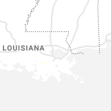
Hail Map for Friday, June 3, 2022

Number of Impacted Households on 6/3/2022
0
Impacted by 1" or Larger Hail
0
Impacted by 1.75" or Larger Hail
0
Impacted by 2.5" or Larger Hail
Square Miles of Populated Area Impacted on 6/3/2022
0
Impacted by 1" or Larger Hail
0
Impacted by 1.75" or Larger Hail
0
Impacted by 2.5" or Larger Hail


Cities Most Affected by Hail Storms of 6/3/2022
| Hail Size | Demographics of Zip Codes Affected | ||||||
|---|---|---|---|---|---|---|---|
| City | Count | Average | Largest | Pop Density | House Value | Income | Age |
| Lancaster, SC | 2 | 1.75 | 1.75 | 162 | $76k | $33.9k | 39.0 |
| Carlsbad, NM | 1 | 2.00 | 2.00 | 16 | $65k | $32.8k | 38.4 |
| Yeso, NM | 1 | 1.75 | 1.75 | 0 | $875k | $19.8k | 49.3 |
Hail and Wind Damage Spotted on 6/3/2022
Filter by Report Type:Hail ReportsWind Reports
States Impacted
South Carolina, North Carolina, Washington, New Mexico, Alabama, Florida, Wyoming, Montana, Georgia, Colorado, Texas, NebraskaSouth Carolina
| Local Time | Report Details |
|---|---|
| 1:55 PM EDT | Sc highway patrol reported a tree down blocking the roadway on blacks dr near the intersection with rolling green circle. time estimated from rada in greenville county SC, 18.3 miles E of Greenville, SC |
| 1:56 PM EDT | Social media video of a large tree limb on power lin in greenville county SC, 15.2 miles ENE of Greenville, SC |
| 2:28 PM EDT | Quarter sized hail reported near Simpsonville, SC, 21.1 miles E of Greenville, SC |
| 2:30 PM EDT | Sc highway patrol reported a tree in roadway at the intersection of trammel rd and sc 146. time estimated from rada in spartanburg county SC, 26.9 miles E of Greenville, SC |
| 2:40 PM EDT | York county emergency management reported a tree fell on a roof on propst rd. time estimated from rada in york county SC, 30.7 miles WSW of Charlotte, NC |
| 2:45 PM EDT | York county emergency management reported multiple trees down on s beersheba rd. time estimated from rada in york county SC, 30.4 miles WSW of Charlotte, NC |
| 2:50 PM EDT | York county emergency management reported multiple trees down on cedar grove rd. time estimated from rada in york county SC, 29.4 miles WSW of Charlotte, NC |
| 2:50 PM EDT | Sc highway patrol reported a tree in roadway near the intersection of us 221 on hobbysville rd. time estimated from rada in spartanburg county SC, 34.7 miles E of Greenville, SC |
| 2:55 PM EDT | York county emergency management reported multiple trees down blocking the intersection of black hwy and windy hill rd. time estimated from rada in york county SC, 28.9 miles WSW of Charlotte, NC |
| 3:00 PM EDT | York county emergency management reported multiple trees down on powerlines on liberty st in york. time estimated from rada in york county SC, 28 miles WSW of Charlotte, NC |
| 3:00 PM EDT | York county emergency management reported multiple trees down on california rd near york. time estimated from rada in york county SC, 28.8 miles SW of Charlotte, NC |
| 3:05 PM EDT | Broadcast media reported a large tree snapped into multiple pieces in pauline. time estimated from rada in spartanburg county SC, 41.5 miles E of Greenville, SC |
| 3:05 PM EDT | Resident on murph rd reported dozens of trees down across their property... with several blocking the driveway. several large trees were uprooted and several more trees in spartanburg county SC, 40.4 miles E of Greenville, SC |
| 3:10 PM EDT | Sc highway patrol reported a tree blocking all lanes at the intersection of sc 215 and west rd. time estimated from rada in spartanburg county SC, 43.8 miles E of Greenville, SC |
| 3:15 PM EDT | York county emergency management reported multiple trees down on daves rd near mcconnells. time estimated from rada in york county SC, 30.2 miles SW of Charlotte, NC |
| 3:20 PM EDT | Broadcast media reported a large tree fell on two parked cars in a residential driveway in the crossing neighborhood. time estimated from rada in york county SC, 23.3 miles SW of Charlotte, NC |
| 3:30 PM EDT | York county emergency management reported multiple trees down near the marshall rd and dalene ave intersection. time estimated from rada in york county SC, 27 miles SSW of Charlotte, NC |
| 3:50 PM EDT | York county emergency management reported multiple trees down near the intersection of hall spencer rd and collins rd. time estimated from rada in york county SC, 27.7 miles SSW of Charlotte, NC |
| 3:50 PM EDT | Sc highway patrol reported a tree in roadway at the intersection of hillside church rd and bowater pass. time estimated from rada in greenville county SC, 26.4 miles SE of Greenville, SC |
| 3:55 PM EDT | York county emergency management reported multiple trees down at the 4600 block of curenton ferry rd. time estimated from rada in york county SC, 25.4 miles S of Charlotte, NC |
| 4:00 PM EDT | Tree in the road along reservation r in york county SC, 25.3 miles S of Charlotte, NC |
| 4:10 PM EDT | Sc highway patrol reported a tree in roadway at the intersection of sc 14 and nehemiah dr. time estimated from rada in laurens county SC, 35 miles ESE of Greenville, SC |
| 4:15 PM EDT | Quarter sized hail reported near Huger, SC, 17.1 miles E of Charleston, SC, broadcast media relayed via social media a picture of quarter sized hail which fell in thomas corner in berkeley county. time was estimated from radar data. |
| 4:25 PM EDT | Several trees down by highway 5 and riverside roa in lancaster county SC, 25.7 miles S of Charlotte, NC |
| 4:27 PM EDT | Golf Ball sized hail reported near Lancaster, SC, 26.4 miles S of Charlotte, NC, also very strong winds... but no estimate on speed. |
| 4:30 PM EDT | Golf Ball sized hail reported near Lancaster, SC, 31.7 miles S of Charlotte, NC, half dollar to golf ball sized hail. lots of trees down and power poles snapped in the vicinity as well. pictures forwarded on social media. time estimated from radar. |
| 4:34 PM EDT | Quarter sized hail reported near Lancaster, SC, 29.4 miles S of Charlotte, NC |
| 4:40 PM EDT | Estimated 60 mph wind gus in lancaster county SC, 34.6 miles SSE of Charlotte, NC |
| 4:46 PM EDT | Large number of trees down in many portions of northern lancaster count in lancaster county SC, 34.2 miles S of Charlotte, NC |
| 5:07 PM EDT | Sc state highway patrol reported a tree down along u.s. route 321 south of tarboro road. time was estimated from radar dat in jasper county SC, 31.1 miles N of Savannah, GA |
| 5:10 PM EDT | Sc state highway patrol reported a tree down in the roadway along interstate 95 near mile marker 28. time was estimated from radar dat in jasper county SC, 35.7 miles NNE of Savannah, GA |
| 5:10 PM EDT | Two broken power poles on west elizabeth street in jefferson. winds estimated of 50-60 mph. picture of damage received through social medi in chesterfield county SC, 46.9 miles SSE of Charlotte, NC |
| 5:11 PM EDT | Uprooted pine tree at e. elizabeth street and douglass stree in chesterfield county SC, 47.2 miles SSE of Charlotte, NC |
| 5:15 PM EDT | Sc state highway patrol reported a tree down in the roadway along nuna rock road. time was estimated from radar dat in jasper county SC, 38.1 miles NNE of Savannah, GA |
| 5:24 PM EDT | Sc state highway patrol reported a tree down in the roadway at the intersection of castle hall road and old sheldon church road. time was estimated from radar dat in beaufort county SC, 43.8 miles NNE of Savannah, GA |
| 5:25 PM EDT | 1 inch hail reported and tree limbs down. power out for a short tim in hampton county SC, 44.9 miles NNE of Savannah, GA |
| 5:25 PM EDT | Quarter sized hail reported near Yemassee, SC, 44.9 miles NNE of Savannah, GA, public reported quarter sized hail and tree limbs down just north of yemassee. time was estimated from report and from radar data. |
| 5:27 PM EDT | Sc state highway patrol reported a tree down in the roadway at the intersection of hendersonville highway and jonesville avenue. time was estimated from radar dat in colleton county SC, 47.9 miles NNE of Savannah, GA |
| 5:27 PM EDT | Sc state highway patrol reported a tree down in the roadway at the intersection of u.s. routes 21 and 17a. time was estimated from radar dat in colleton county SC, 47.2 miles NNE of Savannah, GA |
| 5:57 PM EDT | Tree down blocking the roadway. time estimated from rada in sumter county SC, 59.6 miles NNW of Charleston, SC |
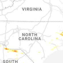
North Carolina
| Local Time | Report Details |
|---|---|
| 2:25 PM EDT | Several trees blown down. pickup truck blown over. crops damaged. railroad bed road was closed for a time due to tree damage. possible tornado. time estimated based on in washington county NC, 77.8 miles SSW of Virginia Beach, VA |
| 3:05 PM EDT | A few trees down in jamesville. near swinson road and grey farm road. time estimated by rada in martin county NC, 76.6 miles SW of Virginia Beach, VA |
| 4:20 PM EDT | Resident on dapple ridge rd reported dime-size hail and multiple utility poles down. time estimated from rada in union county NC, 26.5 miles S of Charlotte, NC |
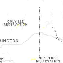
Washington
| Local Time | Report Details |
|---|---|
| 1:25 PM PDT | Colville tribe reports debris on road near the intersection of sr 21 and silver creek rd. not impeding trave in ferry county WA, 44.9 miles ESE of Omak, WA |
New Mexico
| Local Time | Report Details |
|---|---|
| 2:55 PM MDT | Quarter sized hail reported near Hope, NM, 46.8 miles SW of Roswell, NM, quarter size hail along u.s. 82. |
| 5:18 PM MDT | Quarter sized hail reported near Lakewood, NM, 56.2 miles S of Roswell, NM |
| 5:36 PM MDT | Golf Ball sized hail reported near Yeso, NM, 71.6 miles SW of Tucumcari, NM |
| 5:49 PM MDT | Golf Ball sized hail reported near , , 74.8 miles SE of Roswell, NM |
| 6:05 PM MDT | Mesonet station mlcn5 mills 4 wsw (mills canyon in harding county NM, 68.8 miles NNW of Tucumcari, NM |
| 6:38 PM MDT | Hen Egg sized hail reported near Carlsbad, NM, 79.4 miles S of Roswell, NM, report from mping: hen egg (2.00 in.). |
Alabama
| Local Time | Report Details |
|---|---|
| 3:57 PM CDT | Tree down along county road 112 near mount zion churc in dale county AL, 84.1 miles NE of Miramar Beach, FL |
Florida
| Local Time | Report Details |
|---|---|
| 4:10 PM CDT | Fire department relayed a report of several trees down near the intersection of poverty creek road and county road 39 in okaloosa county FL, 29.5 miles N of Miramar Beach, FL |
| 4:35 PM CDT | Wind damage to a home on beaver dam rd. trees down... plus small hail reporte in walton county FL, 27.7 miles N of Miramar Beach, FL |
| 6:25 PM CDT | 911 call center reported a tree down on river stree in calhoun county FL, 45.3 miles W of Tallahassee, FL |
Wyoming
| Local Time | Report Details |
|---|---|
| 3:26 PM MDT | Quarter sized hail reported near Pine Bluffs, WY, 51.6 miles SSW of Scottsbluff, NE |
| 8:05 PM MDT | Quarter sized hail reported near Midwest, WY, 38.7 miles N of Casper, WY, a trained spotter reported quarter size hail. there are also numerous reports on nickel size hail around midwest and edgerton. |
Montana
| Local Time | Report Details |
|---|---|
| 4:04 PM MDT | Mesonet station ylwm8 yellow mule raws. time estimated. gust occurred sometime during the previous hour. station elevation: 9200 f in gallatin county MT, 38.6 miles SSW of Bozeman, MT |
| 7:45 PM MDT | Storm damage reported in yellowstone county MT, 38.2 miles NNE of Billings, MT |
Georgia
| Local Time | Report Details |
|---|---|
| 6:29 PM EDT | Delayed report. tree down over railroad tracks near the intersection of hopkins break rd and hwy 2 in wayne county GA, 56 miles SW of Savannah, GA |
| 8:20 PM EDT | Tree down on watauga road in decatur county GA, 24.8 miles NNW of Tallahassee, FL |
Colorado
| Local Time | Report Details |
|---|---|
| 5:01 PM MDT | Half Dollar sized hail reported near Kim, CO, 96.1 miles SE of Pueblo, CO, storm chaser reported via spotter network. |
| 5:12 PM MDT | Quarter sized hail reported near Las Animas, CO, 75.9 miles E of Pueblo, CO |
| 5:22 PM MDT | Quarter sized hail reported near Las Animas, CO, 77 miles E of Pueblo, CO |
| 5:30 PM MDT | Ping Pong Ball sized hail reported near Sterling, CO, 38.5 miles NNW of Yuma, CO |
| 5:33 PM MDT | Quarter sized hail reported near Kit Carson, CO, 98.6 miles S of Yuma, CO, dispatch relayed a report of heavy rain with hail up to the size of quarters around mile marker 129 on highway 287. |
| 5:53 PM MDT | Quarter sized hail reported near Bethune, CO, 53.7 miles SSE of Yuma, CO, spotter reported hail beginning with pea... increasing to a few quarters in size. hail is now back down to pea with heavy rain falling. |
| 6:03 PM MDT | Mesonet station ew7755 akro in washington county CO, 25.4 miles W of Yuma, CO |
| 6:25 PM MDT | Dispatch relayed a report of near zero visibility in rain with estimated 60 to 70 mph wind gust in cheyenne county CO, 83.4 miles SW of Colby, KS |
| 6:37 PM MDT | Quarter sized hail reported near Vernon, CO, 23.2 miles SE of Yuma, CO, reported hail growing from pea to quarter sized. still falling as of the call. |
| 6:37 PM MDT | Reported 60 mph gust on personal statio in yuma county CO, 23.2 miles SE of Yuma, CO |
| 7:17 PM MDT | Site welp farm in yuma county CO, 25.1 miles ESE of Yuma, CO |
| 7:34 PM MDT | Mesonet station co047 385n220 idali in yuma county CO, 35.4 miles SE of Yuma, CO |
| 7:44 PM MDT | Site 385n21956rws1se in yuma county CO, 36.2 miles SE of Yuma, CO |
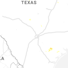
Texas
| Local Time | Report Details |
|---|---|
| 7:39 PM CDT | Spotter reported multiple large trees snapped near fm 883. small hail was also reporte in goliad county TX, 53.5 miles NNW of Corpus Christi, TX |
| 8:09 PM CDT | Asos station kdht dalhart (asos in hartley county TX, 69 miles NW of Amarillo, TX |
| 8:09 PM CDT | Storm damage reported in sherman county TX, 81.2 miles NNW of Amarillo, TX |
| 8:12 PM CDT | Quarter sized hail reported near , , 105.6 miles W of Odessa, TX |
| 9:01 PM CDT | Storm damage reported in winkler county TX, 48.1 miles W of Odessa, TX |
| 10:20 PM CDT | At the crane mesone in crane county TX, 29.6 miles S of Odessa, TX |
| 2:50 AM CDT | Del rio aso in val verde county TX, 2.2 miles WNW of Del Rio, TX |
| 5:22 AM CDT | 60 mph gust measured by the asos located at burnet municipal airpor in burnet county TX, 40 miles SW of Killeen, TX |
Nebraska
| Local Time | Report Details |
|---|---|
| 7:08 PM MDT | Half Dollar sized hail reported near Imperial, NE, 56.7 miles ENE of Yuma, CO |
| 10:02 PM CDT | Ping Pong Ball sized hail reported near Stapleton, NE, 13.8 miles NNE of North Platte, NE |
Connect with Interactive Hail Maps