

Hail Map for Sunday, March 3, 2019

Number of Impacted Households on 3/3/2019
0
Impacted by 1" or Larger Hail
0
Impacted by 1.75" or Larger Hail
0
Impacted by 2.5" or Larger Hail
Square Miles of Populated Area Impacted on 3/3/2019
0
Impacted by 1" or Larger Hail
0
Impacted by 1.75" or Larger Hail
0
Impacted by 2.5" or Larger Hail


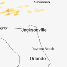
Cities Most Affected by Hail Storms of 3/3/2019
| Hail Size | Demographics of Zip Codes Affected | ||||||
|---|---|---|---|---|---|---|---|
| City | Count | Average | Largest | Pop Density | House Value | Income | Age |
| Macon, GA | 1 | 2.00 | 2.00 | 297 | $107k | $51.9k | 39.8 |
| Fitzgerald, GA | 1 | 1.75 | 1.75 | 66 | $61k | $27.4k | 37.3 |
| Byron, GA | 1 | 1.75 | 1.75 | 263 | $99k | $47.2k | 37.5 |
| Rebecca, GA | 1 | 1.75 | 1.75 | 10 | $61k | $31.9k | 41.0 |
Hail and Wind Damage Spotted on 3/3/2019
Filter by Report Type:Hail ReportsWind Reports
Mississippi
| Local Time | Report Details |
|---|---|
| 10:55 AM CST | A tree downed on power lines across hickory avenu in jasper county MS, 76.6 miles ESE of Jackson, MS |
| 11:28 AM CST | Tree down & partially blocking tuckers crossing rd near ellzey r in jones county MS, 78.4 miles SE of Jackson, MS |
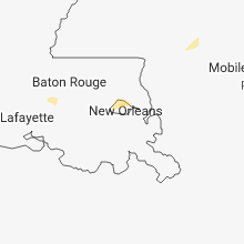
Louisiana
| Local Time | Report Details |
|---|---|
| 12:10 PM CST | Quarter sized hail reported near Grosse Tete, LA, 36.9 miles ENE of Lafayette, LA |
Florida
| Local Time | Report Details |
|---|---|
| 12:53 PM CST | Tree down in pittma in holmes county FL, 50.5 miles NE of Miramar Beach, FL |
| 4:15 PM CST | Scattered trees down in the northern part of walton count in walton county FL, 43 miles NNE of Miramar Beach, FL |
| 4:36 PM CST | 61 mph wind gust reported on eglin af in okaloosa county FL, 17 miles NNW of Miramar Beach, FL |
| 4:40 PM CST | All i-10 eastbound lanes closed near mm 83 due to downed tree in walton county FL, 26 miles NNE of Miramar Beach, FL |
| 4:43 PM CST | Bob sikes road near highway 331 closed with trees over the road. debris near walmar in walton county FL, 25.7 miles NNE of Miramar Beach, FL |
| 4:45 PM CST | Power line down in est in holmes county FL, 59.4 miles NE of Miramar Beach, FL |
| 5:20 PM CST | Tree down in the bonifay are in holmes county FL, 49.6 miles NE of Miramar Beach, FL |
| 5:30 PM CST | Report of a power line down on rex circl in washington county FL, 55.7 miles ENE of Miramar Beach, FL |
| 5:32 PM CST | Ecp... northwest florida - international aprt reported 62 mph wind in bay county FL, 33.5 miles E of Miramar Beach, FL |
| 5:34 PM CST | Powerlines... power poles... and trees down on alford road near the jackson county lin in washington county FL, 57.1 miles ENE of Miramar Beach, FL |
| 5:41 PM CST | At least 3 homes with significant damage near brock and syfrett road in jackson county FL, 62.6 miles ENE of Miramar Beach, FL |
| 6:00 PM CST | Photo of trees down in the altha are in calhoun county FL, 51.5 miles W of Tallahassee, FL |
| 6:15 PM CST | Trees and power lines reported down throughout calhoun count in calhoun county FL, 47.8 miles W of Tallahassee, FL |
| 7:18 PM EST | Power line down in bristo in liberty county FL, 41.8 miles W of Tallahassee, FL |
| 7:45 PM EST | Tree down in hosfor in liberty county FL, 31.2 miles W of Tallahassee, FL |
| 8:20 PM EST | Trees and power lines down on mahan d in leon county FL, 10.8 miles ENE of Tallahassee, FL |
| 8:30 PM EST | Fallen trees or limbs resulted in a power outage. report via duke energy websit in jefferson county FL, 18.6 miles ENE of Tallahassee, FL |
| 8:30 PM EST | Fallen trees or limbs resulted in a power outag in wakulla county FL, 13.8 miles S of Tallahassee, FL |
| 8:40 PM EST | Down trees and power poles reported near the walmart in crawfordville... f in wakulla county FL, 15.9 miles SSW of Tallahassee, FL |
| 8:40 PM EST | Tree down on woodville highwa in wakulla county FL, 14.1 miles SSE of Tallahassee, FL |
| 9:20 PM EST | Fallen trees or limbs resulted in a power outag in taylor county FL, 43.9 miles ESE of Tallahassee, FL |
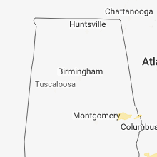
Alabama
| Local Time | Report Details |
|---|---|
| 12:57 PM CST | Storm spotter reports several trees and powerlines down across hwy 17 five miles south of chatom... al. possible tornado damage. time estimated by rada in washington county AL, 51.9 miles NNW of Mobile, AL |
| 1:25 PM CST | Trees down along cr 19 north of autaugavill in autauga county AL, 49.1 miles NE of Camden, AL |
| 1:27 PM CST | Trees down along cr 45 nw of autaugavill in autauga county AL, 47.3 miles NE of Camden, AL |
| 1:45 PM CST | Tree blocking road at walker springs road near overstreet grocer in clarke county AL, 44.2 miles SSW of Camden, AL |
| 2:35 PM CST | Damage reported to homes and multiple trees down near steiner store road and spring creek rd northeast of greenville... al. possible tornado. time estimated by rada in butler county AL, 49 miles E of Camden, AL |
| 2:39 PM CST | Damage reported to trees and structures near the vicinity of bowden road. possible tornado. time estimated from rada in crenshaw county AL, 52 miles E of Camden, AL |
| 2:40 PM CST | Damage reported to trees and structures near the vicinity of white road. possible tornado. time estimated from rada in crenshaw county AL, 52 miles E of Camden, AL |
| 2:43 PM CST | Several trees and treetops down nw of atmore... al along jack springs rd. time estimated by rada in escambia county AL, 40.9 miles NE of Mobile, AL |
| 3:20 PM CST | Bullock county ema reports numerous trees down near the blues stand and perote communities. time estimated by radar. possible tornado damag in bullock county AL, 44.8 miles SSW of Auburn, AL |
| 3:35 PM CST | Several trees down along open pond rd with one falling on a car. time estimated by rada in covington county AL, 51.5 miles N of Miramar Beach, FL |
| 4:26 PM CST | Corrects previous tstm wnd dmg report from 1 se newton. power pole down on hartford street in dale county. corrected time of even in dale county AL, 79.6 miles NE of Miramar Beach, FL |
| 4:55 PM CST | Multiple trees and powerlines down with trees on houses reporte in geneva county AL, 66.8 miles NE of Miramar Beach, FL |
| 5:13 PM CST | Power pole down on hartford street in dale count in dale county AL, 79.6 miles NE of Miramar Beach, FL |
| 5:30 PM CST | Trees down near 10808 east county road in houston county AL, 65.3 miles NW of Tallahassee, FL |
Georgia
| Local Time | Report Details |
|---|---|
| 2:55 PM EST | Quarter sized hail reported near Ashburn, GA, 49.2 miles WNW of Douglas, GA, quarter size hail reported in ashburn georgia. |
| 2:55 PM EST | Power lines down at the 400 block of philema roa in dougherty county GA, 77.1 miles W of Douglas, GA |
| 3:10 PM EST | Golf Ball sized hail reported near Rebecca, GA, 43.6 miles WNW of Douglas, GA, golf ball sized hail reported sw of rebecca. quarter and golf ball size hail covered and accumulated on highway 112. |
| 3:10 PM EST | Quarter sized hail reported near Blakely, GA, 75.7 miles NNW of Tallahassee, FL, quarter size hail at the 911 center at the early county sheriffs office. |
| 3:25 PM EST | Golf Ball sized hail reported near Byron, GA, 80.4 miles SSE of Atlanta, GA, ham radio report of golf ball sized hail north of byron |
| 3:30 PM EST | Hen Egg sized hail reported near Macon, GA, 84.9 miles SSE of Atlanta, GA, em reports 2 inch hail at bibb-macon regional airport |
| 3:39 PM EST | Quarter sized hail reported near Portal, GA, 58.4 miles WNW of Savannah, GA, a picture on facebook was relayed by the broadcast media of hail up to the size of quarters in portal. |
| 3:43 PM EST | Trees down across ga highway 1 blocking the highwa in harris county GA, 36.6 miles ENE of Auburn, AL |
| 3:44 PM EST | Reports of a fallen tree on a house near payne... bibb county on morgan dr in bibb county GA, 74.3 miles SSE of Atlanta, GA |
| 3:50 PM EST | Trees down across ga highway 85 blocking the highwa in harris county GA, 43 miles E of Auburn, AL |
| 4:04 PM EST | Golf Ball sized hail reported near Fitzgerald, GA, 34.6 miles WNW of Douglas, GA, golf ball sized hail reported. |
| 4:10 PM EST | Ping Pong Ball sized hail reported near Chula, GA, 41.4 miles W of Douglas, GA, accumulated quarter to ping pong size hail on interstate 75 between exits 67 and 69. hail accumulated up to an inch on the side of a road. |
| 4:10 PM EST | Quarter sized hail reported near Ocilla, GA, 31.5 miles W of Douglas, GA, quarter size hail reported in the pleasure lake area. |
| 4:30 PM EST | Quarter sized hail reported near Sylvania, GA, 47.8 miles NNW of Savannah, GA, screven 911 center reported quarter size hail near poor robin rd. and hwy 24. |
| 4:32 PM EST | Power poles snapped and tractor trailer tipped over in median of highway 82 near enigma. quarter size hail reported as wel in berrien county GA, 29.1 miles WSW of Douglas, GA |
| 4:34 PM EST | Quarter sized hail reported near Alapaha, GA, 24.2 miles WSW of Douglas, GA, tree down blocking 129 n and quarter size hail. |
| 4:47 PM EST | Screven 911 center reported a tree down at beaver dam road and rolling roa in screven county GA, 47.5 miles SSE of Augusta, GA |
| 4:50 PM EST | Quarter sized hail reported near Ashburn, GA, 49.2 miles WNW of Douglas, GA, quarter size hail in ashburn georgia. |
| 5:02 PM EST | Quarter sized hail reported near Douglas, GA, 3.1 miles NNW of Douglas, GA, media relayed a photo on social media of quarter size hail in douglas... ga at coffee high school. time estimated by radar. |
| 5:02 PM EST | Quarter sized hail reported near Douglas, GA, 0.3 miles N of Douglas, GA, media relayed a photo on social media of quarter size hail in douglas... ga. time estimated by radar. |
| 5:15 PM EST | Damage to a barn along highway 27 sout in quitman county GA, 55.2 miles SSE of Auburn, AL |
| 5:17 PM EST | Quarter sized hail reported near Reidsville, GA, 59.2 miles W of Savannah, GA, tattnall county 911 call center reported that hail the size of quarters fell at the office. |
| 5:30 PM EST | Tree down in ben hill county. exact location not availabl in ben hill county GA, 29.3 miles NW of Douglas, GA |
| 5:50 PM EST | Trees down along highway 3 in clay county GA, 74.5 miles SSE of Auburn, AL |
| 5:50 PM EST | Trees down on washington rd near knob hill farm rd. trees also down on gibbs rd... and conifer trail. roof and shingle damage in berkley hills subdivision. possible tor in columbia county GA, 13.9 miles WNW of Augusta, GA |
| 5:57 PM EST | Power line down around forrester drive and roundtre in terrell county GA, 83.6 miles SE of Auburn, AL |
| 6:00 PM EST | Trees down along highway 2 in clay county GA, 82.2 miles NNW of Tallahassee, FL |
| 6:11 PM EST | 911 call center reported a tree down on highway 15 by red oak roa in appling county GA, 33.7 miles ENE of Douglas, GA |
| 6:16 PM EST | 911 call center reported a tree down on state road 169 near bethesda road blocking the south bound lane. time estimated by rada in wayne county GA, 55.1 miles ENE of Douglas, GA |
| 6:28 PM EST | 2 trees reported down in lear in calhoun county GA, 73.6 miles N of Tallahassee, FL |
| 6:57 PM EST | Multiple trees down near the intersection of barrington ferry road and u.s. 1 in liberty county GA, 30.1 miles SW of Savannah, GA |
| 7:00 PM EST | Trees and power lines down on bur lane roa in seminole county GA, 52.7 miles NW of Tallahassee, FL |
| 7:02 PM EST | *** 1 inj *** multiple vehicular accidents due to storm debris... between mile markers 70 and 73 on i-95. damage included a truck that was hit by storm damage debris. in liberty county GA, 31.6 miles SW of Savannah, GA |
| 7:08 PM EST | Power lines down along whites bridge road. possible tornad in miller county GA, 49.5 miles NNW of Tallahassee, FL |
| 7:09 PM EST | Trees and powerlines down reported on kings road and islands highway on colonels islan in liberty county GA, 27.9 miles SSW of Savannah, GA |
| 7:12 PM EST | Trees and power lines down along south spring creek road. possible tornad in decatur county GA, 39.5 miles NW of Tallahassee, FL |
| 7:20 PM EST | Tree down resulting in a power outage along river oaks driv in decatur county GA, 36.6 miles NW of Tallahassee, FL |
| 7:43 PM EST | Couple of trees down in the omega are in tift county GA, 45.2 miles WSW of Douglas, GA |
South Carolina
| Local Time | Report Details |
|---|---|
| 4:56 PM EST | South carolina highway patrol reported a tree down on old orangeburg road near goodwill roa in hampton county SC, 49.4 miles NNW of Savannah, GA |
| 6:15 PM EST | County em reported a large number of trees down. one home destroyed on woodlawn road in the merriweather distric in edgefield county SC, 9.8 miles NNW of Augusta, GA |
| 6:56 PM EST | Social media report with photos of extensive damage to a gas station in sportsmans corner off martintown rd. multiple gas pumps knocked over with large tree limbs damag in edgefield county SC, 9.6 miles NNW of Augusta, GA |
| 6:59 PM EST | Damage to a roof and fence on maple ridge court. possible tornado. time estimated based on rada in lexington county SC, 49.8 miles NE of Augusta, GA |
| 7:00 PM EST | Power lines downed at robbie rd and muddy springs road. time estimated by radar. possible tornad in lexington county SC, 50.3 miles NE of Augusta, GA |
| 7:05 PM EST | Tree down on a home on westwood dr. time estimated by radar. possible tornad in lexington county SC, 54.3 miles NE of Augusta, GA |
| 7:18 PM EST | Many power lines reported down along with heavy damage along saluda river rd. time estimated by radar. possible tornad in richland county SC, 63.6 miles NE of Augusta, GA |
| 7:18 PM EST | Richland fire reported a collapsed structure on skyland dr. a tree fell through the house. time estimated by radar. possible tornad in richland county SC, 64.1 miles NE of Augusta, GA |
| 7:19 PM EST | Trees down on a vehicle in the 2400 block of lincoln street. possible tornad in richland county SC, 65 miles NE of Augusta, GA |
| 7:20 PM EST | Public reported top twisted from a pine tree and other trees damaged on janna cour in lexington county SC, 56.9 miles NE of Augusta, GA |
| 8:16 PM EST | Columbia pd reported an uprooted tree fell and damaged a home at the 1100 block of price avenue. time estimated based on rada in richland county SC, 65.5 miles NE of Augusta, GA |
Virginia
| Local Time | Report Details |
|---|---|
| 10:05 PM EST | Mesonet station xbbt... third islan in anz632 county VA, 19.7 miles N of Virginia Beach, VA |
Connect with Interactive Hail Maps