

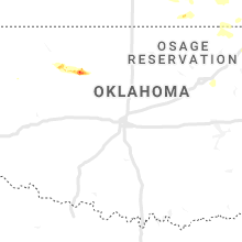
Hail Map for Thursday, May 14, 2020

Number of Impacted Households on 5/14/2020
0
Impacted by 1" or Larger Hail
0
Impacted by 1.75" or Larger Hail
0
Impacted by 2.5" or Larger Hail
Square Miles of Populated Area Impacted on 5/14/2020
0
Impacted by 1" or Larger Hail
0
Impacted by 1.75" or Larger Hail
0
Impacted by 2.5" or Larger Hail


Cities Most Affected by Hail Storms of 5/14/2020
| Hail Size | Demographics of Zip Codes Affected | ||||||
|---|---|---|---|---|---|---|---|
| City | Count | Average | Largest | Pop Density | House Value | Income | Age |
| New Virginia, IA | 3 | 2.50 | 3.00 | 17 | $76k | $42.6k | 43.8 |
| Council Grove, KS | 2 | 1.75 | 1.75 | 12 | $55k | $31.9k | 48.5 |
| Arnett, OK | 1 | 2.50 | 2.50 | 1 | $30k | $28.2k | 45.5 |
| Springfield, MO | 1 | 2.00 | 2.00 | 639 | $191k | $72.5k | 47.0 |
| Fairview, OK | 1 | 1.75 | 1.75 | 10 | $52k | $30.5k | 44.8 |
| Abilene, KS | 1 | 1.75 | 1.75 | 32 | $69k | $37.1k | 42.0 |
| Ozark, MO | 1 | 1.75 | 1.75 | 300 | $99k | $38.6k | 34.6 |
Hail and Wind Damage Spotted on 5/14/2020
Filter by Report Type:Hail ReportsWind Reports
Indiana
| Local Time | Report Details |
|---|---|
| 11:47 AM EDT | Quarter sized hail reported near Leesburg, IN, 39.9 miles WNW of Fort Wayne, IN |
| 11:49 AM EDT | Quarter sized hail reported near Syracuse, IN, 37 miles WNW of Fort Wayne, IN |
Ohio
| Local Time | Report Details |
|---|---|
| 3:45 PM EDT | Approximately one mile track of damage that included two 3ft diameter trees snapped... shingles blown off home... and several limbs snappe in van wert county OH, 32.1 miles ESE of Fort Wayne, IN |
| 4:05 PM EDT | Broken branches on the west side of columbus grov in putnam county OH, 55.4 miles E of Fort Wayne, IN |
| 4:19 PM EDT | Several tree limbs downed in versailles. time estimated by rada in darke county OH, 67.4 miles SSE of Fort Wayne, IN |
| 4:34 PM EDT | Corrects previous non-tstm wnd gst report from 2 sw findlay. asos station kfdy findla in hancock county OH, 74.8 miles E of Fort Wayne, IN |
| 4:35 PM EDT | Several trees downed in the piqua area as well as in newberry township... some of which caused street obstructions. time estimated by rada in miami county OH, 67.4 miles WNW of Columbus, OH |
| 4:41 PM EDT | Several trees downed throughout sidney. time estimated by rada in shelby county OH, 65.3 miles WNW of Columbus, OH |
| 4:42 PM EDT | Corrected time. several trees reported down around tiffi in seneca county OH, 81.5 miles WSW of Cleveland, OH |
| 4:43 PM EDT | Several trees down on house in hancock county OH, 82.5 miles E of Fort Wayne, IN |
| 5:03 PM EDT | Tree down along dialton rd. time estimated by rada in champaign county OH, 50.2 miles W of Columbus, OH |
| 5:10 PM EDT | Tree downed in urbana along rte 54. time estimated by rada in champaign county OH, 40.9 miles WNW of Columbus, OH |
| 5:10 PM EDT | Several large tree limbs downed in concord township. time estimated by rada in champaign county OH, 42.1 miles WNW of Columbus, OH |
| 5:11 PM EDT | Tree fell onto portion of a house along e. ward street. time estimated by rada in champaign county OH, 40.4 miles WNW of Columbus, OH |
| 5:18 PM EDT | Several limbs downed on the north side of springfield. time estimated by rada in clark county OH, 42.9 miles W of Columbus, OH |
| 5:24 PM EDT | Several tress down and siding ripped off of a few houses. a garage door was blown i in erie county OH, 57.5 miles W of Cleveland, OH |
| 5:37 PM EDT | Down power lines and pole in huron county OH, 52.3 miles WSW of Cleveland, OH |
| 5:42 PM EDT | Quarter sized hail reported near Marion, OH, 43.7 miles N of Columbus, OH, quarter (1.00 in.). |
| 5:42 PM EDT | Several trees reported down around tiffi in seneca county OH, 81.5 miles WSW of Cleveland, OH |
| 5:47 PM EDT | Several trees downed in the plain city area. time estimated by rada in union county OH, 17.5 miles NW of Columbus, OH |
| 6:00 PM EDT | Couple trees reported down northeast part of morrow count in morrow county OH, 49.6 miles NNE of Columbus, OH |
| 6:11 PM EDT | Several reports of trees dow in richland county OH, 59.4 miles NNE of Columbus, OH |
| 6:14 PM EDT | Large tree downed onto vehicle near intersection of thompson rd. and preserve crossing blvd. time estimated by rada in franklin county OH, 10.6 miles NE of Columbus, OH |
Missouri
| Local Time | Report Details |
|---|---|
| 3:17 PM CDT | Ping Pong Ball sized hail reported near Rogersville, MO, 7.6 miles SE of Springfield, MO, largest hail stones of 1 to 1.5 inches. |
| 3:17 PM CDT | Hen Egg sized hail reported near Springfield, MO, 7.3 miles SSE of Springfield, MO, photo of hail larger than golf balls at highland springs golf course. time estimated from radar. |
| 3:18 PM CDT | Golf Ball sized hail reported near Ozark, MO, 8.2 miles SSE of Springfield, MO, public report of golf ball sized hail at evans road and highway 65. |
| 3:27 PM CDT | Quarter sized hail reported near Springfield, MO, 6.4 miles SSE of Springfield, MO |
| 3:30 PM CDT | Quarter sized hail reported near Springfield, MO, 5.3 miles SE of Springfield, MO |
| 4:06 PM CDT | Quarter sized hail reported near Springfield, MO, 7.3 miles NNW of Springfield, MO |
| 4:19 PM CDT | Quarter sized hail reported near Springfield, MO, 7.3 miles NNW of Springfield, MO, report from mping: quarter (1.00 in.). |
| 5:07 PM CDT | Quarter sized hail reported near Seymour, MO, 30.2 miles E of Springfield, MO, nickel to quarter size hail. |
| 5:55 PM CDT | Tree limbs and power lines down in av in douglas county MO, 39.2 miles ESE of Springfield, MO |
| 6:59 PM CDT | Quarter sized hail reported near Brookfield, MO, 70.3 miles NW of Columbia, MO, relayed from facebook. |
| 7:05 PM CDT | Half Dollar sized hail reported near Meadville, MO, 77.6 miles NW of Columbia, MO, from meadville fire dept. |
| 9:06 PM CDT | Ping Pong Ball sized hail reported near Maryville, MO, 84.6 miles SE of Omaha, NE |
| 10:52 PM CDT | Also reported quarter sized hail with the win in adair county MO, 56.9 miles W of Kahoka, MO |
| 10:52 PM CDT | Quarter sized hail reported near Green Castle, MO, 56.9 miles W of Kahoka, MO, also reported wind of 70 mph. |
Iowa
| Local Time | Report Details |
|---|---|
| 4:18 PM CDT | Golf Ball sized hail reported near New Virginia, IA, 29.1 miles SSW of Des Moines, IA |
| 4:19 PM CDT | Half Dollar sized hail reported near New Virginia, IA, 28.2 miles SSW of Des Moines, IA |
| 4:22 PM CDT | Baseball sized hail reported near New Virginia, IA, 28.9 miles SSW of Des Moines, IA, delayed report and time estimated by radar. report via woi-dt weather and social media. |
| 4:24 PM CDT | Quarter sized hail reported near New Virginia, IA, 26.2 miles S of Des Moines, IA, 1.5 miles northwest of medora... iowa. |
| 4:30 PM CDT | Tea Cup sized hail reported near New Virginia, IA, 28.9 miles SSW of Des Moines, IA |
| 4:35 PM CDT | Half Dollar sized hail reported near Indianola, IA, 27.6 miles S of Des Moines, IA |
| 5:00 PM CDT | Quarter sized hail reported near Milo, IA, 22.6 miles SSE of Des Moines, IA |
| 5:13 PM CDT | Quarter sized hail reported near Indianola, IA, 27.7 miles S of Des Moines, IA, report from mping: quarter (1.00 in.). |
| 5:55 PM CDT | Multiple large trees limbs down along highway g62 or pierce drive about 3 miles east of pershin in marion county IA, 41 miles ESE of Des Moines, IA |
| 6:35 PM CDT | Report from mping: 3-inch tree limbs broken; power poles broke in mahaska county IA, 65 miles ESE of Des Moines, IA |
| 7:01 PM CDT | Trees and power lines down. machine shed blown into road. time estimated based on rada in keokuk county IA, 59.5 miles SW of Cedar Rapids, IA |
| 7:05 PM CDT | Large buildings damaged. power lines and trees down. time estimate in keokuk county IA, 57.2 miles SW of Cedar Rapids, IA |
| 7:09 PM CDT | Quarter sized hail reported near Kirkville, IA, 64.9 miles NW of Kahoka, MO |
| 7:09 PM CDT | Quarter sized hail reported near Sigourney, IA, 56.4 miles SSW of Cedar Rapids, IA, report from mping: quarter (1.00 in.). |
| 7:30 PM CDT | 4 inch diameter branch down. spotter estimated winds from the rfd to be near 75 mph. time estimate in keokuk county IA, 54.8 miles NNW of Kahoka, MO |
| 8:05 PM CDT | 5 inch limb down. some ditches are filling up and some streets have 2 inches of water on them. time estimate in washington county IA, 52 miles N of Kahoka, MO |
| 8:13 PM CDT | Several large tree limbs dow in henry county IA, 45.1 miles NNE of Kahoka, MO |
| 8:18 PM CDT | Storm damage reported in washington county IA, 53.4 miles S of Cedar Rapids, IA |
| 9:42 PM CDT | Storm damage reported in des moines county IA, 40.1 miles NE of Kahoka, MO |
Kansas
| Local Time | Report Details |
|---|---|
| 5:56 PM CDT | Quarter sized hail reported near Emporia, KS, 56.3 miles SSE of Manhattan, KS, via kvoe radio. |
| 6:05 PM CDT | Quarter sized hail reported near Emporia, KS, 55.9 miles SSE of Manhattan, KS, relayed via kvoe radio. |
| 7:53 PM CDT | Golf Ball sized hail reported near Abilene, KS, 44 miles SW of Manhattan, KS, mostly quarter-size hail... one golf ball size. time estimated from radar. |
| 8:07 PM CDT | Golf Ball sized hail reported near Council Grove, KS, 40 miles S of Manhattan, KS |
| 8:07 PM CDT | Half Dollar sized hail reported near Abilene, KS, 41.1 miles SW of Manhattan, KS, mostly quarter-size hail... some half-dollar. lasted about 3-4 minutes. |
| 9:38 PM CDT | Quarter sized hail reported near Council Grove, KS, 33.9 miles S of Manhattan, KS |
| 9:54 PM CDT | Golf Ball sized hail reported near Council Grove, KS, 33.2 miles S of Manhattan, KS |
| 9:57 PM CDT | Quarter sized hail reported near Americus, KS, 48.9 miles SSE of Manhattan, KS |
| 10:00 PM CDT | Quarter sized hail reported near Reading, KS, 45.8 miles SE of Manhattan, KS, report from mping: quarter (1.00 in.). |
| 10:18 PM CDT | Quarter sized hail reported near Cottonwood Falls, KS, 55.8 miles S of Manhattan, KS, lots of hail. mainly quarters |
| 10:40 PM CDT | Storm damage reported in coffey county KS, 50.2 miles N of Chanute, KS |
| 12:20 AM CDT | Quarter sized hail reported near Le Roy, KS, 30.6 miles NNW of Chanute, KS, hail covering the ground from pea to quarter size. |
| 1:15 AM CDT | Quarter sized hail reported near Rose Hill, KS, 15.2 miles ESE of Wichita, KS, corrected for location. |
| 1:15 AM CDT | Quarter sized hail reported near Rose Hill, KS, 15.2 miles SE of Wichita, KS |
| 1:26 AM CDT | Quarter sized hail reported near Rose Hill, KS, 13.9 miles SE of Wichita, KS |
| 1:30 AM CDT | Quarter sized hail reported near Iola, KS, 17.3 miles N of Chanute, KS, north side of town. |
| 1:36 AM CDT | Storm damage reported in allen county KS, 15.6 miles NNE of Chanute, KS |
| 2:24 AM CDT | Storm damage reported in elk county KS, 46.7 miles WSW of Chanute, KS |
| 5:31 AM CDT | Quarter sized hail reported near Thayer, KS, 19.6 miles S of Chanute, KS, along highway 169. |
Louisiana
| Local Time | Report Details |
|---|---|
| 6:55 PM CDT | Tree reported blown down onto the frontage road at the intersection of interstate 55 and louisiana highway 2 in tangipahoa county LA, 40.6 miles NW of New Orleans, LA |
Oklahoma
| Local Time | Report Details |
|---|---|
| 8:12 PM CDT | Quarter sized hail reported near Waynoka, OK, 24.5 miles E of Woodward, OK |
| 9:09 PM CDT | Quarter sized hail reported near Arnett, OK, 27.6 miles SW of Woodward, OK |
| 9:20 PM CDT | Half Dollar sized hail reported near Waynoka, OK, 34.9 miles E of Woodward, OK |
| 9:27 PM CDT | Tennis Ball sized hail reported near Arnett, OK, 22 miles SW of Woodward, OK |
| 11:50 PM CDT | Quarter sized hail reported near Fairview, OK, 52.5 miles ESE of Woodward, OK |
| 12:00 AM CDT | Golf Ball sized hail reported near Fairview, OK, 54.7 miles ESE of Woodward, OK |
Illinois
| Local Time | Report Details |
|---|---|
| 9:13 PM CDT | Quarter sized hail reported near Roseville, IL, 56.9 miles W of Peoria, IL |
| 9:45 PM CDT | Corrects previous tstm wnd dmg report from burgess. several power outages near and southeast of burges in mercer county IL, 62.4 miles WNW of Peoria, IL |
| 10:10 PM CDT | Trees and power lines downed just west of momence along river road. report relayed via ham operator. time estimated via rada in kankakee county IL, 50.1 miles S of Chicago, IL |
| 10:15 PM CDT | Trained spotter reports power poles damaged northeast of momence. report relayed via ham radio operator. time estimated by rada in kankakee county IL, 47.2 miles S of Chicago, IL |
| 10:18 PM CDT | Roof blown off a barn... also reported tree damage north of the location. possible tornado damage. time estimated from rada in henry county IL, 51.6 miles NNW of Peoria, IL |
| 10:23 PM CDT | Several power poles down. time estimate in knox county IL, 45.2 miles WNW of Peoria, IL |
| 10:27 PM CDT | Several power poles down. time estimate in knox county IL, 43.3 miles W of Peoria, IL |
| 10:55 PM CDT | Large tree branch fell on a hous in peoria county IL, 18.4 miles NW of Peoria, IL |
| 11:06 PM CDT | Township outbuilding damage in peoria county IL, 14.6 miles NNW of Peoria, IL |
| 11:10 PM CDT | Lee county emergency management reports tree damage in woodhaven area near sublette. time estimated by rada in lee county IL, 67.8 miles NNE of Peoria, IL |
| 11:18 PM CDT | Part of roof uplifted in tow in lee county IL, 68 miles NNE of Peoria, IL |
| 11:35 PM CDT | Photo shared via social media of tree damage just north of leland. time estimated by rada in la salle county IL, 62.8 miles WSW of Chicago, IL |
| 11:35 PM CDT | Adds to previous tstm wnd dmg report from paw paw. numerous trees downed in town including along chicago road... chapman street... and maple street. time estimated via in lee county IL, 70.9 miles W of Chicago, IL |
| 11:41 PM CDT | Several power outages near and southeast of burges in mercer county IL, 62.4 miles WNW of Peoria, IL |
| 11:50 PM CDT | Large tree snappe in de kalb county IL, 62.1 miles WSW of Chicago, IL |
| 11:55 PM CDT | Trees and power lines downed. time estimated per rada in de kalb county IL, 56.9 miles W of Chicago, IL |
| 12:00 AM CDT | Corrects previous report incorrectly listed as flood report. photo shared via social media of tree damage north of hinckley. time estimated via rada in de kalb county IL, 52.7 miles W of Chicago, IL |
| 12:06 AM CDT | Large branches of a few trees snappe in de kalb county IL, 52.6 miles W of Chicago, IL |
| 12:25 AM CDT | Asos station karr sugar grove - aurora arp in kane county IL, 44.5 miles W of Chicago, IL |
Colorado
| Local Time | Report Details |
|---|---|
| 11:05 PM MDT | Quarter sized hail reported near Kim, CO, 78.3 miles SE of Pueblo, CO |
Connect with Interactive Hail Maps