

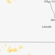
Hail Map for Thursday, May 24, 2018

Number of Impacted Households on 5/24/2018
0
Impacted by 1" or Larger Hail
0
Impacted by 1.75" or Larger Hail
0
Impacted by 2.5" or Larger Hail
Square Miles of Populated Area Impacted on 5/24/2018
0
Impacted by 1" or Larger Hail
0
Impacted by 1.75" or Larger Hail
0
Impacted by 2.5" or Larger Hail


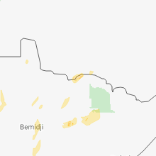


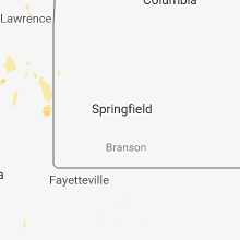


Cities Most Affected by Hail Storms of 5/24/2018
| Hail Size | Demographics of Zip Codes Affected | ||||||
|---|---|---|---|---|---|---|---|
| City | Count | Average | Largest | Pop Density | House Value | Income | Age |
Hail and Wind Damage Spotted on 5/24/2018
Filter by Report Type:Hail ReportsWind Reports
States Impacted
North Dakota, Kansas, Minnesota, Mississippi, South Dakota, Texas, Colorado, NebraskaNorth Dakota
| Local Time | Report Details |
|---|---|
| 8:42 AM CDT | Quarter sized hail reported near Langdon, ND, 63.5 miles NNE of Devils Lake, ND, pictures shared by local news show accumulated quarter sized hail. time estimated from radar. |
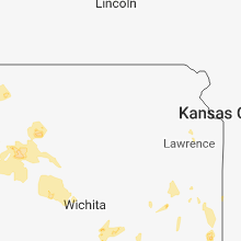
Kansas
| Local Time | Report Details |
|---|---|
| 3:15 PM CDT | Numerous branches and one large tree down. standalone carport and trampoline launche in butler county KS, 17.8 miles E of Wichita, KS |
| 5:15 PM MDT | Storm chaser is also a spotter. he reported near zero visibility in blowing dust as the gust front went through weska in wallace county KS, 61.6 miles SW of Colby, KS |
| 5:36 PM MDT | Quarter sized hail reported near Sharon Springs, KS, 50.7 miles SW of Colby, KS |
| 5:39 PM MDT | Quarter sized hail reported near Sharon Springs, KS, 51.6 miles SW of Colby, KS |
| 6:45 PM CDT | Half Dollar sized hail reported near Winona, KS, 29.4 miles SSW of Colby, KS |
| 5:45 PM MDT | Storm damage reported in greeley county KS, 60.2 miles NW of Garden City, KS |
| 6:49 PM CDT | Quarter sized hail reported near Winona, KS, 28.5 miles SSW of Colby, KS |
| 6:55 PM CDT | Quarter sized hail reported near Wallace, KS, 31.1 miles SW of Colby, KS |
| 6:58 PM CDT | Storm damage reported in thomas county KS, 11.9 miles ENE of Colby, KS |
| 7:28 PM CDT | Quarter sized hail reported near Manter, KS, 66.3 miles WSW of Garden City, KS, ground is covered with hail... some nickle size... however most looks like at least quarter size. |
| 7:58 PM CDT | Quarter sized hail reported near Manter, KS, 61.1 miles WSW of Garden City, KS |
| 9:24 PM CDT | Quarter sized hail reported near Hill City, KS, 44.3 miles NW of Hays, KS |
| 9:54 PM CDT | Quarter sized hail reported near Stockton, KS, 37 miles N of Hays, KS, nickel to quarter size hail ongoing at webster state park. |
Minnesota
| Local Time | Report Details |
|---|---|
| 4:05 PM CDT | Tree down. report courtesy of wcco. time estimate in renville county MN, 27 miles ESE of Montevideo, MN |
| 6:18 PM CDT | Trees and power lines dow in mcleod county MN, 45.8 miles WSW of Minneapolis, MN |
| 6:30 PM CDT | Power lines dow in carver county MN, 35.7 miles WSW of Minneapolis, MN |
| 6:35 PM CDT | Glencoe airport gusted to 61 mp in mcleod county MN, 42.8 miles WSW of Minneapolis, MN |
| 6:50 PM CDT | Power lines dow in carver county MN, 27.5 miles WSW of Minneapolis, MN |
| 6:50 PM CDT | Trees and power lines down. power pole down on a ca in carver county MN, 28.7 miles W of Minneapolis, MN |
| 7:10 PM CDT | Trees down along highway 1 in scott county MN, 14.1 miles SSW of Minneapolis, MN |
| 7:15 PM CDT | Trees down. time estimate in hennepin county MN, 13.2 miles NW of Minneapolis, MN |
| 7:25 PM CDT | Large pole shed damage in pope county MN, 37.9 miles N of Montevideo, MN |
| 7:25 PM CDT | Tree dow in carver county MN, 28.7 miles W of Minneapolis, MN |
| 7:30 PM CDT | Tree limbs down near 40th and nicollet in south minneapoli in hennepin county MN, 3.5 miles SSW of Minneapolis, MN |
| 7:38 PM CDT | Storm damage reported in hennepin county MN, 7 miles SSE of Minneapolis, MN |
| 7:44 PM CDT | Quarter sized hail reported near Minneapolis, MN, 1.8 miles ESE of Minneapolis, MN, 1 inch hail cedar riverside neighborhood. |
| 7:45 PM CDT | Several trees uprooted... at least six power poles down on the north side of highway 13... near washburn av in dakota county MN, 14 miles S of Minneapolis, MN |
| 7:58 PM CDT | Trees and power lines down. time estimate in rice county MN, 47.6 miles S of Minneapolis, MN |
| 7:58 PM CDT | Trees down in wells township. time estimate in rice county MN, 46.3 miles S of Minneapolis, MN |
| 8:00 PM CDT | Trees and power lines dow in washington county MN, 15.9 miles ENE of Minneapolis, MN |
| 8:35 PM CDT | Storm damage reported in pope county MN, 52 miles NNE of Montevideo, MN |
| 8:50 PM CDT | Roof blown off shed... landing on a road in the northern edge of denniso in goodhue county MN, 40.8 miles SSE of Minneapolis, MN |
| 9:00 PM CDT | Power line down. time estimate in douglas county MN, 69.2 miles NNE of Montevideo, MN |
| 9:05 PM CDT | Tree dow in goodhue county MN, 36.8 miles SSE of Minneapolis, MN |
| 9:05 PM CDT | Quarter sized hail reported near Crookston, MN, 62.3 miles N of Fargo, ND |
| 9:41 PM CDT | Quarter sized hail reported near Crookston, MN, 62.6 miles N of Fargo, ND |
| 10:10 PM CDT | Storm damage reported in pennington county MN, 54.2 miles SSW of Roseau, MN |
Mississippi
| Local Time | Report Details |
|---|---|
| 4:10 PM CDT | Six trees and some power lines were down. there was also some small hai in lowndes county MS, 23.5 miles E of Starkville, MS |
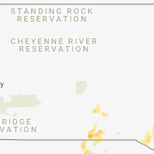
South Dakota
| Local Time | Report Details |
|---|---|
| 5:02 PM CDT | Half Dollar sized hail reported near Dante, SD, 41.2 miles NE of Oneill, NE, hail covered the ground. |
| 5:22 PM CDT | Quarter sized hail reported near Scotland, SD, 59.5 miles WSW of Sioux Falls, SD |
| 5:35 PM CDT | Quarter sized hail reported near Hamill, SD, 59.7 miles SSE of Pierre, SD |
| 6:58 PM CDT | Quarter sized hail reported near Gregory, SD, 66.9 miles NE of Valentine, NE, time estimated off radar. |
| 7:50 PM CDT | Ping Pong Ball sized hail reported near Winner, SD, 30.9 miles ENE of Valentine, NE |
| 7:50 PM CDT | Ping Pong Ball sized hail reported near Winner, SD, 33.3 miles ENE of Valentine, NE |
| 8:10 PM CDT | Quarter sized hail reported near Colome, SD, 46.8 miles ENE of Valentine, NE |
Texas
| Local Time | Report Details |
|---|---|
| 6:00 PM CDT | Power pole blown down... and signs shattered and blown down due to strong winds and hai in brewster county TX, 0.3 miles WNW of Alpine, TX |
| 6:15 PM CDT | Quarter sized hail reported near , , 56.6 miles NNW of Alpine, TX, at chevron gas station. lasted approximately 20 minutes. |
| 9:06 PM CDT | The abilene police dept. reported a utility pole down... in the buttonwillow area of abilen in taylor county TX, 0.7 miles E of Abilene, TX |
Colorado
| Local Time | Report Details |
|---|---|
| 5:27 PM MDT | Quarter sized hail reported near Bethune, CO, 58.7 miles SSE of Yuma, CO, hail reported 3 miles west and 1 and half mile south of hwy 24. |
| 6:25 PM MDT | Quarter sized hail reported near Bethune, CO, 50.8 miles SSE of Yuma, CO |
Nebraska
| Local Time | Report Details |
|---|---|
| 8:00 PM CDT | Quarter sized hail reported near Wood Lake, NE, 18 miles ESE of Valentine, NE, hail up to quarter size. |
Connect with Interactive Hail Maps