

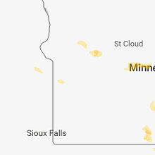
Hail Map for Friday, May 25, 2018

Number of Impacted Households on 5/25/2018
0
Impacted by 1" or Larger Hail
0
Impacted by 1.75" or Larger Hail
0
Impacted by 2.5" or Larger Hail
Square Miles of Populated Area Impacted on 5/25/2018
0
Impacted by 1" or Larger Hail
0
Impacted by 1.75" or Larger Hail
0
Impacted by 2.5" or Larger Hail


Cities Most Affected by Hail Storms of 5/25/2018
| Hail Size | Demographics of Zip Codes Affected | ||||||
|---|---|---|---|---|---|---|---|
| City | Count | Average | Largest | Pop Density | House Value | Income | Age |
| De Leon, TX | 1 | 4.25 | 4.25 | 25 | $40k | $25.8k | 43.2 |
| Huxley, IA | 2 | 1.88 | 2.00 | 174 | $121k | $50.6k | 32.5 |
| Comanche, TX | 1 | 2.75 | 2.75 | 16 | $45k | $29.4k | 43.0 |
| Caldwell, ID | 1 | 2.00 | 2.00 | 123 | $115k | $39.6k | 34.9 |
| Ames, IA | 1 | 1.75 | 1.75 | 500 | $125k | $37.5k | 30.2 |
| Conger, MN | 1 | 1.75 | 1.75 | 0 | $45k | $35.6k | 35.5 |
| Alden, MN | 1 | 1.75 | 1.75 | 16 | $72k | $42.4k | 44.7 |
| New Meadows, ID | 1 | 1.75 | 1.75 | 3 | $116k | $29.9k | 48.6 |
| Eleva, WI | 1 | 1.75 | 1.75 | 31 | $88k | $42.0k | 41.8 |
| Melba, ID | 1 | 1.75 | 1.75 | 20 | $115k | $33.5k | 37.1 |
| Santo, TX | 1 | 1.75 | 1.75 | 10 | $43k | $38.2k | 43.1 |
| Gordon, TX | 1 | 1.75 | 1.75 | 6 | $55k | $35.9k | 51.7 |
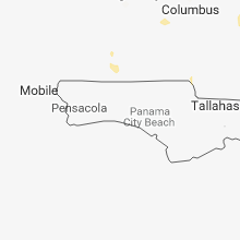
Hail and Wind Damage Spotted on 5/25/2018
Filter by Report Type:Hail ReportsWind Reports
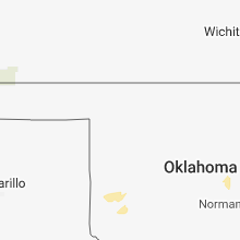
States Impacted
Oklahoma, Texas, Nevada, Mississippi, Louisiana, Oregon, Minnesota, Wisconsin, Arkansas, South Dakota, Tennessee, Missouri, Georgia, Iowa, North Dakota, IdahoOklahoma
| Local Time | Report Details |
|---|---|
| 11:00 AM CDT | Marena sit in payne county OK, 43.5 miles NNE of Oklahoma City, OK |
| 4:57 PM CDT | Quarter sized hail reported near Earlsboro, OK, 42.9 miles ESE of Oklahoma City, OK |
| 8:40 PM CDT | Half Dollar sized hail reported near Sayre, OK, 60.4 miles NE of Childress, TX |
| 9:15 PM CDT | Quarter sized hail reported near Mangum, OK, 43.4 miles NE of Childress, TX, dime to quarter hail in reed. |
Texas
| Local Time | Report Details |
|---|---|
| 1:20 PM CDT | Power poles down near hwy 380 and 2 miles west of 75 in mckinney in collin county TX, 30.8 miles NNE of Dallas, TX |
| 3:15 PM CDT | Tree uproote in smith county TX, 81.4 miles NNW of Lufkin, TX |
| 5:05 PM CDT | Golf Ball sized hail reported near Santo, TX, 85.9 miles W of Dallas, TX, east side of lake palo pinto |
| 5:15 PM CDT | Quarter sized hail reported near Gordon, TX, 84.2 miles E of Abilene, TX |
| 5:15 PM CDT | Golf Ball sized hail reported near Gordon, TX, 85 miles E of Abilene, TX, wind shields broken out of cars on the west end of lake palo lake near the marina. |
| 5:18 PM CDT | Quarter sized hail reported near Gordon, TX, 80.4 miles E of Abilene, TX |
| 5:45 PM CDT | Quarter sized hail reported near Stephenville, TX, 81.9 miles E of Abilene, TX, at cr121 and cr116 |
| 5:50 PM CDT | Storm damage reported in hardeman county TX, 16.7 miles ESE of Childress, TX |
| 6:39 PM CDT | Grapefruit sized hail reported near De Leon, TX, 72.1 miles ESE of Abilene, TX, baseball with some softball size hail on hwy 16 4 miles north of de leon |
| 7:20 PM CDT | Baseball sized hail reported near Comanche, TX, 75.4 miles NW of Killeen, TX, baseball size hail reported 1 ssw comanche |
| 7:24 PM CDT | Quarter sized hail reported near Canadian, TX, 77 miles SW of Woodward, OK, storm chaser reported quarter size hail via spotter network. |
| 7:30 PM CDT | Quarter sized hail reported near Canadian, TX, 77 miles SW of Woodward, OK, report received via twitter. |
| 7:33 PM CDT | Half Dollar sized hail reported near Mobeetie, TX, 77.8 miles SW of Woodward, OK, report received via twitter. |
| 7:45 PM CDT | Half Dollar sized hail reported near Mobeetie, TX, 78.4 miles N of Childress, TX, report received via spotter network. |
| 7:51 PM CDT | Half Dollar sized hail reported near Mobeetie, TX, 78.5 miles N of Childress, TX, half dollar size received via spotter network. |
| 8:09 PM CDT | Quarter sized hail reported near Zephyr, TX, 73.8 miles WNW of Killeen, TX, tons of pea size hail with 3 inch drifts. |
| 8:10 PM CDT | Brownwood pd reported power lines... trees down and power poles down across brownwood and earl in brown county TX, 67.4 miles SE of Abilene, TX |
| 8:11 PM CDT | Tree damage in zephy in brown county TX, 73.8 miles WNW of Killeen, TX |
| 8:50 PM CDT | Emergency manager reported uprooted trees in richland springs and winds estimated at 80 to 90 mph between 850 and 9p in san saba county TX, 72.6 miles W of Killeen, TX |
| 8:51 PM CDT | Damaging thunderstorm winds knocking down power poles in richland springs. winds were reported to be very stron in san saba county TX, 72.6 miles W of Killeen, TX |
| 9:03 PM CDT | Storm damage reported in jones county TX, 34 miles N of Abilene, TX |
| 9:55 PM CDT | Quarter sized hail reported near Mason, TX, 89.7 miles WSW of Killeen, TX, hail fell between 0955 and 0959 pm and it covered the ground. |
| 10:11 PM CDT | Law enforcement officials reported tractor trailers were blown over on top car in callahan county TX, 14.5 miles ESE of Abilene, TX |
| 10:11 PM CDT | Law enforcement officials reported tractor trailers were blown over on top car in callahan county TX, 11.4 miles E of Abilene, TX |
Nevada
| Local Time | Report Details |
|---|---|
| 11:37 AM PDT | The black rock playa raws sensor reported a thunderstorm wind gust of 61 mp in pershing county NV, 78.1 miles W of Winnemucca, NV |
Mississippi
| Local Time | Report Details |
|---|---|
| 1:48 PM CDT | Corrects previous tstm wnd dmg report from satartia. tree down and a fence damaged. cattle escape in yazoo county MS, 33.1 miles NW of Jackson, MS |
| 2:46 PM CDT | Trees dow in warren county MS, 31.3 miles WNW of Jackson, MS |
| 2:48 PM CDT | Tree down and a fence damaged. cattle escape in yazoo county MS, 33.1 miles NW of Jackson, MS |
| 3:18 PM CDT | Tree down on s frontage r in hinds county MS, 10.3 miles WNW of Jackson, MS |
| 5:00 PM CDT | Natchez trace electric power reported 3 trees downed in the vicinity of eupor in webster county MS, 26.9 miles W of Starkville, MS |
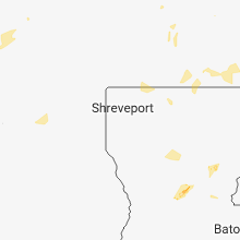
Louisiana
| Local Time | Report Details |
|---|---|
| 2:52 PM CDT | Microburst winds observed at barksdale afb with peak gust of 54 kts recorded on airfield sensor. large tree limbs... some over 5 inches in diameter... were snappe in bossier county LA, 4.5 miles E of Shreveport, LA |
| 6:00 PM CDT | Large tree down on a house in downtown culle in webster county LA, 35.8 miles NNE of Shreveport, LA |
| 6:00 PM CDT | Trees reported down across parts of springhil in webster county LA, 37.8 miles NNE of Shreveport, LA |
Oregon
| Local Time | Report Details |
|---|---|
| 1:00 PM PDT | Quarter sized hail reported near Fields, OR, 85.3 miles NNW of Winnemucca, NV, social media report. hail occured around 2 pm mdt just north of denio... nv on the idaho side. |
| 2:00 PM PDT | Quarter sized hail reported near Fields, OR, 85.3 miles NNW of Winnemucca, NV, social media report. hail occured around 3 pm pdt just north of denio... nv on the idaho side. |
| 4:10 PM PDT | Trees and powerlines down. parts of town without powe in harney county OR, 0.4 miles NW of Burns, OR |
| 8:29 PM PDT | Quarter sized hail reported near Imnaha, OR, 42.7 miles SW of Grangeville, ID |
Minnesota
| Local Time | Report Details |
|---|---|
| 3:30 PM CDT | Ping Pong Ball sized hail reported near Alden, MN, 42.7 miles NNW of Mason City, IA |
| 3:36 PM CDT | Quarter sized hail reported near Lewiston, MN, 33 miles WNW of La Crosse, WI |
| 4:00 PM CDT | Golf Ball sized hail reported near Alden, MN, 40.1 miles NNW of Mason City, IA, reported via twitter... time estimated. |
| 4:00 PM CDT | Golf Ball sized hail reported near Conger, MN, 36 miles NNW of Mason City, IA, reported via twitter. |
| 4:45 PM CDT | Quarter sized hail reported near Osseo, MN, 18.8 miles NW of Minneapolis, MN |
| 4:45 PM CDT | Quarter sized hail reported near Saint Michael, MN, 25.1 miles NW of Minneapolis, MN |
| 5:00 PM CDT | Tree fell on car near 75th and fernbroo in hennepin county MN, 12.2 miles NW of Minneapolis, MN |
| 8:31 PM CDT | Rochester international airport official observatio in olmsted county MN, 62.7 miles W of La Crosse, WI |
Wisconsin
| Local Time | Report Details |
|---|---|
| 3:31 PM CDT | Golf Ball sized hail reported near Eleva, WI, 54.1 miles NNW of La Crosse, WI |
| 5:00 PM CDT | Quarter sized hail reported near Stanley, WI, 80.7 miles N of La Crosse, WI, two separate phone calls from the public. |
| 5:00 PM CDT | Quarter sized hail reported near Deer Park, WI, 50.8 miles ENE of Minneapolis, MN, reported via facebook. |
| 6:05 PM CDT | Few trees and a power line dow in st. croix county WI, 39.1 miles ENE of Minneapolis, MN |
| 6:19 PM CDT | Quarter sized hail reported near Hayward, WI, 64.3 miles SSE of Duluth, MN |
| 7:05 PM CDT | Several reports of trees and power lines down between ferryville and lynxville. time estimated from radar... but damage likely occurred between 6:55 pm and 7:15 p in crawford county WI, 33.7 miles SSE of La Crosse, WI |
| 7:10 PM CDT | Tree down on county hwy o in marinette county WI, 66.4 miles E of Rhinelander, WI |
| 7:15 PM CDT | Tree down... partially on roa in dunn county WI, 65 miles ESE of Minneapolis, MN |
| 7:15 PM CDT | Tree down on trailer hom in dunn county WI, 66.6 miles E of Minneapolis, MN |
| 7:24 PM CDT | Trees down on power line near falling rock r in crawford county WI, 48.8 miles S of La Crosse, WI |
| 7:28 PM CDT | Trees reported down near the village of eastma in crawford county WI, 46.5 miles SSE of La Crosse, WI |
| 7:40 PM CDT | Tree down... partially on roa in eau claire county WI, 72.3 miles NNW of La Crosse, WI |
| 7:53 PM CDT | Storm damage reported in crawford county WI, 53.3 miles SSE of La Crosse, WI |
Arkansas
| Local Time | Report Details |
|---|---|
| 3:33 PM CDT | Numerous tree limbs down ranging from 3 inch to 6 inch in diameter. radar time estimate in franklin county AR, 26.5 miles ENE of Fort Smith, AR |
| 5:39 PM CDT | Tree down on a house in montrose from sub-severe wind gust. picture received via social medi in ashley county AR, 43.3 miles NNE of Bastrop, LA |
South Dakota
| Local Time | Report Details |
|---|---|
| 2:45 PM MDT | Quarter sized hail reported near Fairburn, SD, 28.9 miles SSE of Rapid City, SD, mostly dime size a few to quarter size |
| 5:01 PM CDT | Quarter sized hail reported near Freeman, SD, 39.6 miles WSW of Sioux Falls, SD |
Tennessee
| Local Time | Report Details |
|---|---|
| 4:12 PM CDT | A few trees down near highway 231 in walterhill. one house was damaged by a large tre in rutherford county TN, 26.5 miles ESE of Nashville, TN |
Missouri
| Local Time | Report Details |
|---|---|
| 4:30 PM CDT | This storm broke our neighbors huge... gorgeous tree in half =( also blew our patio furniture and bbq across the field. busted lattice doors off our porch as well as ou in greene county MO, 8.2 miles SE of Springfield, MO |
| 5:42 PM CDT | Corrects previous tstm wnd dmg report from 1 nnw bradleyville. reports of large limbs and power lines down near hwy 125 and skyline roa in taney county MO, 35.2 miles SE of Springfield, MO |
| 5:42 PM CDT | Corrects previous tstm wnd dmg report from 1 nnw bradleyville. reports of large limbs and power lines down near hwy 125 and skyline roa in taney county MO, 35.2 miles SE of Springfield, MO |
| 6:20 PM CDT | High winds with branches falling in thornfield. 3-4 inches in diamete in ozark county MO, 49 miles SE of Springfield, MO |
| 6:20 PM CDT | Corrects previous tstm wnd dmg report from 1 nnw bradleyville for location and time. reports of large limbs and power lines down near hwy 125 and skyline road. location in taney county MO, 35.2 miles SE of Springfield, MO |
| 6:25 PM CDT | Large limbs and power lines down near hwy 125 skyline r in christian county MO, 32.8 miles SE of Springfield, MO |
| 6:40 PM CDT | Norwood fire chief reporting some trees down app 1 east of norwood on cherokee rd. largest one app 18 inch base. fire chief reports trees laying to the south. time esti in wright county MO, 50.2 miles E of Springfield, MO |
Georgia
| Local Time | Report Details |
|---|---|
| 6:30 PM EDT | Two trees were blown down onto power lines on hwy 57 two miles west of wrightsvill in johnson county GA, 67.9 miles SW of Augusta, GA |
Iowa
| Local Time | Report Details |
|---|---|
| 6:12 PM CDT | Quarter sized hail reported near Ames, IA, 32.5 miles N of Des Moines, IA, amateur radio reported quarter hail. |
| 6:15 PM CDT | Quarter sized hail reported near Ames, IA, 31.8 miles N of Des Moines, IA, trained spotter reported quarter hail. |
| 6:18 PM CDT | Half Dollar sized hail reported near Ames, IA, 31.8 miles N of Des Moines, IA, public relayed picture of half dollar to ping pong ball sized hail in north ames. came via text message picture. |
| 6:31 PM CDT | Ames municipal recorded a 61 mph wind gus in story county IA, 27.6 miles N of Des Moines, IA |
| 6:44 PM CDT | Numerous reports of trees down across northern allamakee county the past 10-15 minute in allamakee county IA, 31.3 miles S of La Crosse, WI |
| 6:44 PM CDT | Golf Ball sized hail reported near Ames, IA, 27 miles N of Des Moines, IA, public reported estimated golf ball sized hail along i-35 south of ames. report via text message. |
| 6:53 PM CDT | Ping Pong Ball sized hail reported near Cambridge, IA, 21.8 miles N of Des Moines, IA, trained spotter reported ping pong ball sized hail at the time of the report... and ongoing. |
| 6:55 PM CDT | Hen Egg sized hail reported near Huxley, IA, 21.4 miles N of Des Moines, IA, public reported large hail in huxley... via social media/twitter. |
| 6:57 PM CDT | Golf Ball sized hail reported near Huxley, IA, 21.4 miles N of Des Moines, IA, law enforcement relayed spotter reports of up to golf ball sized hail in huxley. |
| 7:04 PM CDT | Numerous reports of additional trees down across central and southern allamakee count in allamakee county IA, 39.2 miles SSW of La Crosse, WI |
| 7:38 PM CDT | Quarter sized hail reported near Marshalltown, IA, 50.7 miles NE of Des Moines, IA, time estimated from radar. via social media. |
| 7:43 PM CDT | Quarter sized hail reported near Marshalltown, IA, 47.2 miles NE of Des Moines, IA, trained spotter reported quarter sized hail in nw marshalltown. ongoing at the time of the call. |
| 8:04 PM CDT | Quarter sized hail reported near Oelwein, IA, 50.2 miles NNW of Cedar Rapids, IA, pea to quarter size hail. |
| 8:10 PM CDT | Trees dow in dubuque county IA, 61.8 miles NE of Cedar Rapids, IA |
| 8:37 PM CDT | Tree 1 foot in diameter snapped in the wood in dubuque county IA, 62.1 miles NE of Cedar Rapids, IA |
| 1:16 AM CDT | Spotter network report of 60 mph wind in linn county IA, 3.1 miles NNE of Cedar Rapids, IA |
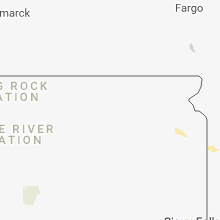
North Dakota
| Local Time | Report Details |
|---|---|
| 6:49 PM CDT | Ndawn site gust measurement arising from small cell in vicinit in cass county ND, 39.1 miles NW of Fargo, ND |
Idaho
| Local Time | Report Details |
|---|---|
| 7:10 PM MDT | Golf Ball sized hail reported near Melba, ID, 29 miles WSW of Boise, ID, golf ball sized hail reported via social media. |
| 7:24 PM MDT | Quarter sized hail reported near Marsing, ID, 31.2 miles W of Boise, ID, one inch hail measured in marsing via social media. |
| 7:35 PM MDT | Half Dollar sized hail reported near Caldwell, ID, 24.5 miles W of Boise, ID, half dollar size hail just north of lake lowell |
| 7:42 PM MDT | Hen Egg sized hail reported near Caldwell, ID, 24.5 miles W of Boise, ID, measured 2 inch hail. |
| 7:48 PM MDT | Golf Ball sized hail reported near New Meadows, ID, 65.1 miles S of Grangeville, ID, spotter reported golf ball sized hail in new meadows. |
Connect with Interactive Hail Maps