

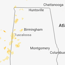
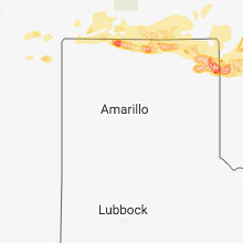
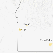
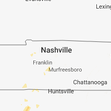
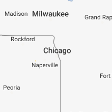
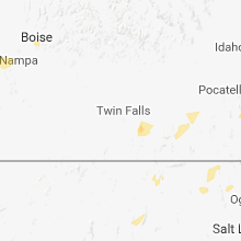
Hail Map for Wednesday, May 30, 2018

Number of Impacted Households on 5/30/2018
0
Impacted by 1" or Larger Hail
0
Impacted by 1.75" or Larger Hail
0
Impacted by 2.5" or Larger Hail
Square Miles of Populated Area Impacted on 5/30/2018
0
Impacted by 1" or Larger Hail
0
Impacted by 1.75" or Larger Hail
0
Impacted by 2.5" or Larger Hail


Cities Most Affected by Hail Storms of 5/30/2018
| Hail Size | Demographics of Zip Codes Affected | ||||||
|---|---|---|---|---|---|---|---|
| City | Count | Average | Largest | Pop Density | House Value | Income | Age |
| Arnett, OK | 3 | 1.75 | 1.75 | 1 | $30k | $28.2k | 45.5 |
| Higgins, TX | 2 | 2.13 | 2.50 | 0 | $28k | $28.9k | 48.4 |
| Lipscomb, TX | 2 | 1.88 | 2.00 | 1 | $29k | $24.4k | 58.8 |
| Texhoma, OK | 1 | 2.00 | 2.00 | 1 | $49k | $38.8k | 36.2 |
Hail and Wind Damage Spotted on 5/30/2018
Filter by Report Type:Hail ReportsWind Reports
States Impacted
Mississippi, Ohio, Indiana, Kentucky, West Virginia, Alabama, Colorado, Michigan, Tennessee, New Mexico, Oklahoma, Idaho, Texas, Kansas, Minnesota, Utah, North Dakota, MontanaMississippi
| Local Time | Report Details |
|---|---|
| 1:10 PM CDT | Several houses damaged including a trailer with siding ripped off. power lines also dow in sunflower county MS, 95.3 miles N of Jackson, MS |
| 3:02 PM CDT | Multiple trees down in the furrs community. widespread power outage in pontotoc county MS, 52.8 miles N of Starkville, MS |
| 3:14 PM CDT | Multiple trees down across both hwy 430 and hwy 17 near black haw in carroll county MS, 69.8 miles W of Starkville, MS |
| 3:19 PM CDT | Roof off of a hom in lee county MS, 63.4 miles N of Starkville, MS |
| 3:42 PM CDT | Tree damage at the ponotoc country clu in pontotoc county MS, 55.2 miles NNW of Starkville, MS |
| 3:50 PM CDT | Large tree down at the piney grove area of bay springs lak in tishomingo county MS, 37.2 miles WSW of Florence, AL |
| 3:51 PM CDT | Tree down on a she in itawamba county MS, 55.7 miles SW of Florence, AL |
| 3:56 PM CDT | Multiple trees down around tishoming in tishomingo county MS, 33.5 miles WSW of Florence, AL |
| 4:05 PM CDT | Tree down across rushing roa in scott county MS, 31.7 miles E of Jackson, MS |
| 4:30 PM CDT | Tree down causing substation outage on industrial park r in oktibbeha county MS, 2.4 miles SW of Starkville, MS |
| 4:47 PM CDT | Tree down on power line in oktibbeha county MS, 1 miles WNW of Starkville, MS |
| 4:47 PM CDT | Damage caused by fallen tree at academy village apartment in oktibbeha county MS, 1.8 miles SSW of Starkville, MS |
| 4:57 PM CDT | Multiple trees down in the clayton village area including curtis chapel road and hickory driv in oktibbeha county MS, 7.1 miles E of Starkville, MS |
| 5:50 PM CDT | Em reports trees down on hwy 18 and 118 near harmon in clarke county MS, 83.9 miles ESE of Jackson, MS |
| 6:25 PM CDT | Quarter sized hail reported near Collinsville, MS, 62.6 miles S of Starkville, MS, em reports quarter sized hail on newton county martin rd. |
| 6:30 PM CDT | Ping Pong Ball sized hail reported near Meridian, MS, 74.5 miles S of Starkville, MS, em and social media reports of hail. |
| 7:52 PM CDT | Quarter sized hail reported near Senatobia, MS, 36.8 miles S of Memphis, TN, nickel to quarter sized hail fell around the fire station. |
| 7:58 PM CDT | Quarter sized hail reported near Senatobia, MS, 36.8 miles S of Memphis, TN, hail in senatobia. |
| 9:10 PM CDT | A tree fell on a house along roberts st... trapping two people. both were unharme in jones county MS, 74 miles SE of Jackson, MS |
| 9:35 PM CDT | Multiple trees downed around jones count in jones county MS, 75.1 miles SE of Jackson, MS |
Ohio
| Local Time | Report Details |
|---|---|
| 3:14 PM EDT | Tree down due to thunderstorm winds. time estimated from radar in warren county OH, 25.1 miles NE of Cincinnati, OH |
| 3:14 PM EDT | Tree down due to thunderstorm winds in deerfield townshi in warren county OH, 19.1 miles NE of Cincinnati, OH |
| 3:19 PM EDT | Tree down in turtle creek township east of lebanon. time estimated from rada in warren county OH, 30.2 miles NE of Cincinnati, OH |
| 3:40 PM EDT | Large branches were downe in montgomery county OH, 44.1 miles NNE of Cincinnati, OH |
| 3:47 PM EDT | Tree downe in greene county OH, 54.4 miles NNE of Cincinnati, OH |
| 4:13 PM EDT | Tree downe in clark county OH, 40.4 miles W of Columbus, OH |
| 5:33 PM EDT | Two trees down at the 103/107 and 103/105 crossroads. time of damage is radar estimate in wyandot county OH, 70.4 miles NNW of Columbus, OH |
| 5:40 PM EDT | More than a few trees down in the area. one tree down on a power line in chester township between chester and sumne in meigs county OH, 52.3 miles NNW of Charleston, WV |
| 5:40 PM EDT | A few trees dow in athens county OH, 53.8 miles SE of Columbus, OH |
| 5:45 PM EDT | Rotted tree fell onto van... reported via twitte in seneca county OH, 86.1 miles NNW of Columbus, OH |
| 6:02 PM EDT | Power pole snapped with lines down on the roadwa in henry county OH, 59.9 miles ENE of Fort Wayne, IN |
| 6:05 PM EDT | Very large tree branch down at sugar ridge and hilt just north of bowling green. reported via twitte in wood county OH, 80.3 miles ENE of Fort Wayne, IN |
| 6:29 PM EDT | Power lines down at route 14 and 10 in sandusky county OH, 88.9 miles W of Cleveland, OH |
| 6:44 PM EDT | Very large tree branch at 287th and 114th in point place fell on power lines. time is radar estimate in lucas county OH, 90.3 miles S of Flint, MI |
| 6:46 PM EDT | Estimated wind gusts of 60 mph reported via twitte in lucas county OH, 90.3 miles W of Cleveland, OH |
Indiana
| Local Time | Report Details |
|---|---|
| 3:20 PM EDT | Report of a tree down on sr 18 just east of the sr 1 intersection. blocking part of sr 1 in jay county IN, 36.4 miles S of Fort Wayne, IN |
| 4:15 PM EDT | 1-2 ft diameter tree limb downed. limb appears health in allen county IN, 10.1 miles SSE of Fort Wayne, IN |
| 4:20 PM EDT | 1-2 ft diameter limb downed on cook rd. tree partially rotte in allen county IN, 7.4 miles NW of Fort Wayne, IN |
| 5:00 PM EDT | Tree downed near 5900 s on 455 e. no information on the size or health of the tre in lagrange county IN, 35.7 miles NNW of Fort Wayne, IN |
| 5:00 PM EDT | Tree downed on cr 600 s-west of sr 9. no information on the size or health of the tre in lagrange county IN, 36.3 miles NNW of Fort Wayne, IN |
| 5:10 PM EDT | Tree downed in the area of 1800 n on 075 e. no information on the size or health of the tre in lagrange county IN, 44.1 miles NNW of Fort Wayne, IN |
| 5:15 PM EDT | Tree downed near 1250 w on 450 n. no information on the size or health of the tre in lagrange county IN, 46 miles NNW of Fort Wayne, IN |
| 5:15 PM EDT | Tree downed near 100 w on 400 n. no information on the size or health of the tre in lagrange county IN, 46.4 miles NNW of Fort Wayne, IN |
| 5:20 PM EDT | 1 ft diameter tree uprooted. blocking road in housing addition at litchfield rd and orchard ct. time estimated by radar. no information on health of the tre in allen county IN, 5.2 miles NE of Fort Wayne, IN |
Kentucky
| Local Time | Report Details |
|---|---|
| 4:25 PM EDT | Kroger sign blown over...time estimated from rada in greenup county KY, 58.6 miles W of Charleston, WV |
West Virginia
| Local Time | Report Details |
|---|---|
| 4:50 PM EDT | Large tree branch about 30 feet long was blown down hanging in the road. estimated wind speed of 50mph was reported by nws employe in kanawha county WV, 10 miles WNW of Charleston, WV |
Alabama
| Local Time | Report Details |
|---|---|
| 4:45 PM CDT | Trees down on county road 36... time estimated from rada in franklin county AL, 24.2 miles SSW of Florence, AL |
| 4:45 PM CDT | Trees down on welch cemetery rd... time estimated from rada in franklin county AL, 25.7 miles SSW of Florence, AL |
| 4:53 PM CDT | Large tree across hwy 172 just southeast of hodges along with numerous small branche in franklin county AL, 35.9 miles SSW of Florence, AL |
| 4:54 PM CDT | Trees down on county road 46... time estimated from rada in franklin county AL, 23.4 miles SSW of Florence, AL |
| 6:36 PM CDT | Tree fell on a powerline on harvest road in east limestone c in limestone county AL, 48.7 miles E of Florence, AL |
| 6:44 PM CDT | Grape arbor that was concreted into the ground was blown over. time estimated from rada in madison county AL, 56.7 miles E of Florence, AL |
Colorado
| Local Time | Report Details |
|---|---|
| 3:55 PM MDT | Quarter sized hail reported near Larkspur, CO, 40.5 miles SSE of Denver, CO |
| 4:23 PM MDT | Quarter sized hail reported near Elbert, CO, 51.4 miles SSE of Denver, CO, quarter size hail fell 4:20 to 4:25 pm. delayed report called in by spotter at 6:20 pm. |
| 5:21 PM MDT | Quarter sized hail reported near Jamestown, CO, 32.3 miles NW of Denver, CO |
Michigan
| Local Time | Report Details |
|---|---|
| 6:07 PM EDT | Multiple trees down in lenawee county MI, 69.6 miles NE of Fort Wayne, IN |
| 6:12 PM EDT | Multiple trees down in lenawee county MI, 77.5 miles NE of Fort Wayne, IN |
| 6:28 PM EDT | Several trees down in lenawee county MI, 64.1 miles NE of Fort Wayne, IN |
| 6:52 PM EDT | 1.5 foot diameter and partially rotted tree limb down. winds estimated 50 mph by spotter. time estimated by radar. corrects previous tstm wnd dmg repor in montcalm county MI, 30.2 miles NNE of Grand Rapids, MI |
| 6:52 PM EDT | 1.5 foot diameter and partially rotted tree limb down. winds estimated 50 mph by spotter. time estimated by radar. corrects previous tstm wnd dmg repor in montcalm county MI, 30.2 miles NNE of Grand Rapids, MI |
| 7:05 PM EDT | Multiple power lines down in monroe county MI, 76.8 miles SSE of Flint, MI |
| 7:58 PM EDT | Tree down across road in livingston county MI, 31.9 miles SW of Flint, MI |
| 8:30 PM EDT | Tree down on roadway in genesee county MI, 14.5 miles SW of Flint, MI |
| 8:50 PM EDT | Delayed report of multiple downed trees throughout shiawassee count in shiawassee county MI, 17.6 miles W of Flint, MI |
| 9:00 PM EDT | Tree down across roadway in genesee county MI, 10.2 miles WNW of Flint, MI |
Tennessee
| Local Time | Report Details |
|---|---|
| 5:12 PM CDT | Received reports of several trees down on power lines in david crockett state park... and trees down in the city. time estimated from rada in lawrence county TN, 36.4 miles NNE of Florence, AL |
New Mexico
| Local Time | Report Details |
|---|---|
| 5:09 PM MDT | Quarter sized hail reported near , , 76.8 miles NNE of Tucumcari, NM, spotter reported 1 inch hail found on road after approximately 15 minutes of melting |
Oklahoma
| Local Time | Report Details |
|---|---|
| 6:47 PM CDT | Quarter sized hail reported near Boise City, OK, 112 miles NNW of Amarillo, TX, quarter sized hail reported just west of boise city. |
| 7:21 PM CDT | Quarter sized hail reported near Boise City, OK, 94.1 miles NNW of Amarillo, TX, trained spotter measured 1.2 inch maximum hail size. |
| 7:40 PM CDT | Eva mesonet reported 60 mph wind gus in texas county OK, 98.5 miles SW of Garden City, KS |
| 8:02 PM CDT | Hen Egg sized hail reported near Texhoma, OK, 86.4 miles N of Amarillo, TX, two inch diameter hail near the intersection of fm 119 and county road d. |
| 8:15 PM CDT | Spotter measured estimated 60 mph wind gus in texas county OK, 94.3 miles SSW of Garden City, KS |
| 9:15 PM CDT | Quarter sized hail reported near Boise City, OK, 111.6 miles NNW of Amarillo, TX |
| 9:22 PM CDT | Quarter sized hail reported near Boise City, OK, 111.8 miles NNW of Amarillo, TX, quarter sized hail in boise city. |
| 9:40 PM CDT | 59 mph wind gust reported at beaver mesone in beaver county OK, 67.8 miles WNW of Woodward, OK |
| 10:05 PM CDT | Ping Pong Ball sized hail reported near Boise City, OK, 107.3 miles NNW of Amarillo, TX, ping pong ball sized hail southeast of boise city. |
| 10:25 PM CDT | Golf Ball sized hail reported near Arnett, OK, 29 miles SW of Woodward, OK, hwy 60 on east side of arnett |
| 10:35 PM CDT | Golf Ball sized hail reported near Arnett, OK, 24 miles SSW of Woodward, OK, on hwy 60 |
| 10:50 PM CDT | Quarter sized hail reported near Guymon, OK, 93.9 miles SSW of Garden City, KS, one inch diameter hail fell near guymon. |
| 10:55 PM CDT | Storm damage reported in woodward county OK, 5.6 miles W of Woodward, OK |
| 10:55 PM CDT | Carport and two sheds destroyed. roof blown off mobile home on the west side of town. timed based on rada in woodward county OK, 13.4 miles NW of Woodward, OK |
| 10:55 PM CDT | Power lines and pole down in sharon. powerlines down in ft. supply as well in woodward county OK, 11.1 miles SSE of Woodward, OK |
| 10:55 PM CDT | Quarter sized hail reported near Guymon, OK, 94.3 miles SSW of Garden City, KS, picture via social media showed quarter sized hail. |
| 10:56 PM CDT | Storm damage reported in woodward county OK, 0.6 miles ESE of Woodward, OK |
| 11:07 PM CDT | Tree... power pole... and several tree limbs blown dow in woodward county OK, 10.5 miles E of Woodward, OK |
| 11:14 PM CDT | Storm damage reported in dewey county OK, 20.3 miles SSE of Woodward, OK |
| 11:19 PM CDT | Wind direction from the northwes in woodward county OK, 1.7 miles ENE of Woodward, OK |
| 11:30 PM CDT | Wind direction west-northwest in woodward county OK, 26.1 miles SE of Woodward, OK |
| 11:45 PM CDT | Storm damage reported in woods county OK, 42.3 miles ENE of Woodward, OK |
| 12:15 AM CDT | Storm damage reported in logan county OK, 43.5 miles N of Oklahoma City, OK |
| 12:15 AM CDT | Storm damage reported in kay county OK, 64.6 miles S of Wichita, KS |
| 12:22 AM CDT | Golf Ball sized hail reported near Arnett, OK, 33.1 miles SW of Woodward, OK, along hwy 283 |
| 12:30 AM CDT | Storm damage reported in logan county OK, 28.7 miles NNE of Oklahoma City, OK |
| 12:40 AM CDT | Storm damage reported in garfield county OK, 65.4 miles N of Oklahoma City, OK |
| 12:45 AM CDT | Storm damage reported in garfield county OK, 65.4 miles N of Oklahoma City, OK |
| 1:30 AM CDT | Storm damage reported in logan county OK, 28.7 miles NNE of Oklahoma City, OK |
| 1:40 AM CDT | Four inch diameter tree limb blown off live maple tre in oklahoma county OK, 12.5 miles N of Oklahoma City, OK |
| 1:55 AM CDT | Storm damage reported in payne county OK, 45.3 miles NE of Oklahoma City, OK |
| 3:17 AM CDT | Large tree down in rogers county OK, 13.9 miles ENE of Tulsa, OK |
Idaho
| Local Time | Report Details |
|---|---|
| 6:00 PM MDT | Half Dollar sized hail reported near Oakley, ID, 26.1 miles SE of Twin Falls, ID, social media picture of half dollar sized hail 6 miles south of murtaugh. |
| 6:00 PM MDT | Half Dollar sized hail reported near Murtaugh, ID, 18.7 miles ESE of Twin Falls, ID, reported via social media. |
Texas
| Local Time | Report Details |
|---|---|
| 7:21 PM CDT | Quarter sized hail reported near Kerrick, TX, 92 miles NNW of Amarillo, TX |
| 7:58 PM CDT | Two semi-trailers likely blown down due to winds. damage is along highway 54... just northeast of county road 1 in sherman county TX, 84.4 miles N of Amarillo, TX |
| 8:44 PM CDT | Half Dollar sized hail reported near Gruver, TX, 82 miles NNE of Amarillo, TX, half dollar sized hail north of gruver. |
| 8:45 PM CDT | Half Dollar sized hail reported near Gruver, TX, 82.3 miles NNE of Amarillo, TX, 1.25 inch diameter hail reported approximately 6 miles north-northeast of gruver. |
| 8:50 PM CDT | Ping Pong Ball sized hail reported near Gruver, TX, 83 miles NNE of Amarillo, TX, half dollar to ping pong ball sized hail fell near the intersection of highway 136 and fm 2535 |
| 9:02 PM CDT | Storm chaser reports a downed power line along highway 15 northeast of spearma in hansford county TX, 81.2 miles NNE of Amarillo, TX |
| 9:07 PM CDT | Ping Pong Ball sized hail reported near Spearman, TX, 84.5 miles NNE of Amarillo, TX, ping pong ball sized hail northeast of gruver. |
| 9:16 PM CDT | Snapped power line approximately 3 to 4 miles southwest of perryton... along highway 1 in ochiltree county TX, 82.1 miles W of Woodward, OK |
| 9:36 PM CDT | After report of wind damage east northeast of lipscom in lipscomb county TX, 48.1 miles WSW of Woodward, OK |
| 9:55 PM CDT | Hen Egg sized hail reported near Lipscomb, TX, 55.4 miles WSW of Woodward, OK, local media posted on social media a picture of large hail about 2 inches in diameter. |
| 10:07 PM CDT | Golf Ball sized hail reported near Lipscomb, TX, 50.6 miles WSW of Woodward, OK |
| 10:15 PM CDT | Large tree limbs across highway 213 just west of 1454 required crews to remov in lipscomb county TX, 45.2 miles WSW of Woodward, OK |
| 10:25 PM CDT | Tennis Ball sized hail reported near Higgins, TX, 41.3 miles WSW of Woodward, OK, all windows blown out on north side of home. |
| 11:25 PM CDT | Golf Ball sized hail reported near Higgins, TX, 41.3 miles WSW of Woodward, OK |
Kansas
| Local Time | Report Details |
|---|---|
| 6:40 PM MDT | Estimated wind gust to 60 mph. blowing dust also observed with visibility briefly falling to a quarter mil in sherman county KS, 32.2 miles WNW of Colby, KS |
| 8:23 PM CDT | Mesonet station kuls... 1 nw ulysse in grant county KS, 37.3 miles SW of Garden City, KS |
| 11:47 PM CDT | Asos station p28... medicine lodge asos sit in barber county KS, 72.4 miles WSW of Wichita, KS |
| 12:12 AM CDT | Quarter sized hail reported near Zenda, KS, 54.6 miles WSW of Wichita, KS |
| 12:12 AM CDT | 55 to 60 mph winds knocked down several small tree branche in kingman county KS, 54.6 miles WSW of Wichita, KS |
| 12:16 AM CDT | 70 mph winds knocked down several large branche in kingman county KS, 54 miles WSW of Wichita, KS |
| 12:24 AM CDT | Storm damage reported in harper county KS, 47 miles SW of Wichita, KS |
| 12:26 AM CDT | Power outages also reporte in harper county KS, 47.4 miles SW of Wichita, KS |
| 12:30 AM CDT | Storm damage reported in harper county KS, 47.4 miles SW of Wichita, KS |
| 12:40 AM CDT | Storm damage reported in harper county KS, 53.2 miles SW of Wichita, KS |
| 1:03 AM CDT | Storm damage reported in sumner county KS, 34.7 miles SSW of Wichita, KS |
| 1:21 AM CDT | Storm damage reported in sedgwick county KS, 15.7 miles SW of Wichita, KS |
| 1:28 AM CDT | Storm damage reported in cowley county KS, 45.5 miles SSE of Wichita, KS |
| 1:32 AM CDT | Storm damage reported in sedgwick county KS, 6.2 miles WNW of Wichita, KS |
| 1:33 AM CDT | Storm damage reported in sedgwick county KS, 0.6 miles SSE of Wichita, KS |
| 1:38 AM CDT | Storm damage reported in cowley county KS, 48.6 miles SSE of Wichita, KS |
| 1:40 AM CDT | Large tree limbs downed near 32nd and amidon. delayed report. time estimated from rada in sedgwick county KS, 4.1 miles NNW of Wichita, KS |
| 1:45 AM CDT | Storm damage reported in sedgwick county KS, 6.2 miles WNW of Wichita, KS |
| 1:48 AM CDT | Storm damage reported in sedgwick county KS, 0.3 miles NW of Wichita, KS |
| 4:17 AM CDT | Mesonet station f0828... 2 sse fort scot in bourbon county KS, 42 miles ENE of Chanute, KS |
Minnesota
| Local Time | Report Details |
|---|---|
| 7:45 PM CDT | Shed damage with roof blown off... tin blown into tree... and tin blown half mile away. time estimate in fillmore county MN, 51.6 miles WSW of La Crosse, WI |
Utah
| Local Time | Report Details |
|---|---|
| 7:35 PM MDT | Salt flats - 4265 f in tooele county UT, 76.8 miles WSW of Salt Lake City, UT |
| 7:55 PM MDT | Camel back mountain - 5077 f in tooele county UT, 71.3 miles SW of Salt Lake City, UT |
| 7:55 PM MDT | Target r - 4311 f in tooele county UT, 83.7 miles WSW of Salt Lake City, UT |
| 8:20 PM MDT | Storm damage reported in tooele county UT, 18.2 miles W of Salt Lake City, UT |
North Dakota
| Local Time | Report Details |
|---|---|
| 10:05 PM CDT | Half Dollar sized hail reported near Zahl, ND, 35.7 miles N of Williston, ND, half dollar size hail. |
Montana
| Local Time | Report Details |
|---|---|
| 9:49 PM MDT | Jdn asos in garfield county MT, 61.8 miles SSW of Glasgow, MT |
| 10:10 PM MDT | Storm damage reported in valley county MT, 0.4 miles NNW of Glasgow, MT |
| 10:11 PM MDT | Ggw asos in valley county MT, 0.4 miles NNW of Glasgow, MT |
Connect with Interactive Hail Maps