

Hail Map for Tuesday, May 29, 2018

Number of Impacted Households on 5/29/2018
0
Impacted by 1" or Larger Hail
0
Impacted by 1.75" or Larger Hail
0
Impacted by 2.5" or Larger Hail
Square Miles of Populated Area Impacted on 5/29/2018
0
Impacted by 1" or Larger Hail
0
Impacted by 1.75" or Larger Hail
0
Impacted by 2.5" or Larger Hail


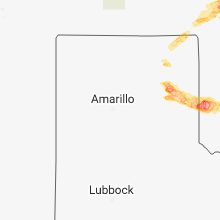


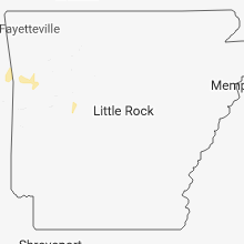
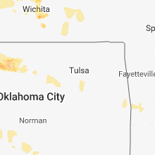
Cities Most Affected by Hail Storms of 5/29/2018
| Hail Size | Demographics of Zip Codes Affected | ||||||
|---|---|---|---|---|---|---|---|
| City | Count | Average | Largest | Pop Density | House Value | Income | Age |
| Freedom, OK | 5 | 2.10 | 2.50 | 1 | $45k | $32.6k | 47.0 |
| Wheeler, TX | 3 | 2.92 | 3.00 | 2 | $42k | $32.9k | 35.1 |
| Erick, OK | 3 | 2.84 | 3.26 | 1 | $25k | $23.4k | 41.7 |
| Dodge City, KS | 3 | 2.83 | 4.00 | 82 | $71k | $37.6k | 29.5 |
| Ford, KS | 2 | 2.75 | 2.75 | 2 | $32k | $35.2k | 40.9 |
| Wichita, KS | 3 | 1.83 | 2.00 | 2381 | $118k | $50.3k | 35.4 |
| Waynoka, OK | 2 | 2.38 | 2.50 | 4 | $26k | $23.7k | 45.2 |
| Mcpherson, KS | 2 | 2.13 | 2.50 | 67 | $86k | $42.0k | 39.9 |
| Greensburg, KS | 2 | 2.00 | 2.00 | 5 | $49k | $30.8k | 45.4 |
| Ellsworth, KS | 2 | 1.88 | 2.00 | 13 | $48k | $37.4k | 39.8 |
| Coldwater, KS | 2 | 1.88 | 2.00 | 1 | $34k | $29.5k | 47.1 |
| Minneola, KS | 2 | 1.88 | 2.00 | 1 | $52k | $33.0k | 42.5 |
| Joes, CO | 2 | 1.75 | 1.75 | 1 | $10k | $40.4k | 45.6 |
| Sayre, OK | 2 | 1.75 | 1.75 | 11 | $33k | $25.8k | 35.6 |
| Protection, KS | 1 | 2.75 | 2.75 | 1 | $25k | $29.5k | 46.8 |
| Miami, TX | 1 | 2.75 | 2.75 | 1 | $48k | $38.1k | 40.5 |
| Sebeka, MN | 1 | 2.00 | 2.00 | 10 | $47k | $31.7k | 42.3 |
| Bucklin, KS | 1 | 2.00 | 2.00 | 1 | $53k | $40.4k | 38.7 |
| Mobeetie, TX | 1 | 2.00 | 2.00 | 2 | $33k | $33.8k | 44.5 |
| Jetmore, KS | 1 | 2.00 | 2.00 | 2 | $48k | $34.5k | 43.8 |
| Byron, MN | 1 | 2.00 | 2.00 | 96 | $119k | $58.1k | 36.6 |
| Buffalo, OK | 1 | 1.75 | 1.75 | 1 | $37k | $32.5k | 41.4 |
| Enid, OK | 1 | 1.75 | 1.75 | 170 | $39k | $26.6k | 33.1 |
| Offerle, KS | 1 | 1.75 | 1.75 | 4 | $32k | $40.3k | 45.9 |
| Booker, TX | 1 | 1.75 | 1.75 | 2 | $46k | $33.2k | 31.5 |
| Spearville, KS | 1 | 1.75 | 1.75 | 3 | $66k | $40.3k | 41.7 |
| Ellinwood, KS | 1 | 1.75 | 1.75 | 15 | $47k | $30.8k | 44.3 |
| Lahoma, OK | 1 | 1.75 | 1.75 | 25 | $55k | $36.5k | 40.6 |
| Alexandria, MN | 1 | 1.75 | 1.75 | 169 | $112k | $38.8k | 43.1 |
| Aline, OK | 1 | 1.75 | 1.75 | 3 | $24k | $31.7k | 48.7 |
| Cache, OK | 1 | 1.75 | 1.75 | 49 | $68k | $36.7k | 36.3 |
| Laverne, OK | 1 | 1.75 | 1.75 | 1 | $40k | $34.0k | 40.0 |
| Hayfield, MN | 1 | 1.75 | 1.75 | 22 | $87k | $45.3k | 38.5 |
| Ringwood, OK | 1 | 1.75 | 1.75 | 10 | $50k | $30.6k | 38.6 |
Hail and Wind Damage Spotted on 5/29/2018
Filter by Report Type:Hail ReportsWind Reports
States Impacted
Minnesota, Nebraska, Ohio, Kansas, Iowa, Tennessee, Oklahoma, South Carolina, Texas, South Dakota, Colorado, Wisconsin, Indiana, Florida, MissouriMinnesota
| Local Time | Report Details |
|---|---|
| 1:32 PM CDT | Quarter sized hail reported near Vesta, MN, 31.1 miles SSE of Montevideo, MN |
| 1:45 PM CDT | Quarter sized hail reported near Hayfield, MN, 59.5 miles NNE of Mason City, IA |
| 2:04 PM CDT | Quarter sized hail reported near West Concord, MN, 61.1 miles SSE of Minneapolis, MN |
| 2:05 PM CDT | Quarter sized hail reported near Echo, MN, 27.2 miles SSE of Montevideo, MN |
| 2:07 PM CDT | Quarter sized hail reported near West Concord, MN, 61.1 miles SSE of Minneapolis, MN |
| 2:10 PM CDT | Golf Ball sized hail reported near Hayfield, MN, 59.5 miles NNE of Mason City, IA, hail grew in size from dime sized to quarter sized to golf ball last few minutes |
| 2:12 PM CDT | Hen Egg sized hail reported near Byron, MN, 60.7 miles NNE of Mason City, IA, via kaal television |
| 2:19 PM CDT | Quarter sized hail reported near Byron, MN, 67 miles NNE of Mason City, IA |
| 2:25 PM CDT | Hen Egg sized hail reported near Sebeka, MN, 58.7 miles S of Bemidji, MN, social media post showing multiple large hail stones around 2 - 2.25 inches. |
| 2:30 PM CDT | Quarter sized hail reported near Hayfield, MN, 54.3 miles NNE of Mason City, IA |
| 2:30 PM CDT | Golf Ball sized hail reported near Alexandria, MN, 68.1 miles NNE of Montevideo, MN, near lake geneva. |
| 2:30 PM CDT | Ping Pong Ball sized hail reported near Hayfield, MN, 54.3 miles NNE of Mason City, IA |
| 2:35 PM CDT | Quarter sized hail reported near Saint Paul, MN, 12.8 miles SSE of Minneapolis, MN, photograph relayed through broadcast media via social media. |
| 2:35 PM CDT | Quarter sized hail reported near Carlos, MN, 78 miles NNE of Montevideo, MN, photograph relayed through social media. |
| 2:40 PM CDT | Quarter sized hail reported near Saint Paul, MN, 12.8 miles SSE of Minneapolis, MN, photograph relayed through social media... 13 solid minutes of pea to quarter sized hail in central eagan. |
| 2:40 PM CDT | Quarter sized hail reported near Saint Paul, MN, 11.7 miles SSE of Minneapolis, MN, photograph relayed through social media. |
| 2:58 PM CDT | Quarter sized hail reported near Rochester, MN, 65.4 miles WNW of La Crosse, WI |
| 3:02 PM CDT | Power pole snapped in wadena county MN, 69.6 miles S of Bemidji, MN |
| 3:03 PM CDT | Reported at hwy 19 and cr-3... gibbon... mn semi turned over on sid in sibley county MN, 66.6 miles WSW of Minneapolis, MN |
| 3:08 PM CDT | Ping Pong Ball sized hail reported near Menahga, MN, 52.1 miles S of Bemidji, MN, picture of hail on facebook |
| 3:08 PM CDT | Via spotter network in hubbard county MN, 38.9 miles S of Bemidji, MN |
| 3:15 PM CDT | Multiple trees uprooted across town. largest estimated around 18-20" in diameter. large branches down on houses. damage concentrated downtown & on the south side of tow in mcleod county MN, 54.6 miles W of Minneapolis, MN |
| 3:15 PM CDT | Several trees and large branches down... including one on a vehicl in mcleod county MN, 55.6 miles W of Minneapolis, MN |
| 3:15 PM CDT | Quarter sized hail reported near Hutchinson, MN, 54.6 miles W of Minneapolis, MN, dime to quarter sized reported. |
| 3:15 PM CDT | Awos station hcd... hutchinson a in mcleod county MN, 55.3 miles W of Minneapolis, MN |
| 3:25 PM CDT | Quarter sized hail reported near Browerville, MN, 91.8 miles NNE of Montevideo, MN, mostly nickels... but a few quarters. |
| 3:26 PM CDT | Quarter sized hail reported near Saint Francis, MN, 29.7 miles NNW of Minneapolis, MN |
| 3:35 PM CDT | Quarter sized hail reported near Glencoe, MN, 50 miles WSW of Minneapolis, MN |
| 3:36 PM CDT | Quarter sized hail reported near Laporte, MN, 24.5 miles SSE of Bemidji, MN, penny to quarter sized hail covered the ground |
| 3:38 PM CDT | Quarter sized hail reported near Park Rapids, MN, 38.9 miles S of Bemidji, MN, hail began as nickel sized... increased to quarter sized. |
| 3:40 PM CDT | Half Dollar sized hail reported near Isanti, MN, 34.2 miles N of Minneapolis, MN |
| 4:05 PM CDT | Strong downburst. blew sheet metal pieces off she in kanabec county MN, 59.7 miles N of Minneapolis, MN |
| 4:05 PM CDT | Trees and power lines dow in isanti county MN, 38.4 miles N of Minneapolis, MN |
| 4:18 PM CDT | Reported at hwy 212 and hilton... glencoe... mn 8 inch diameter tree branch down. 10 to 12 foot diameter tree snapped off at 12 feet up. small branches burning on power in mcleod county MN, 47.6 miles WSW of Minneapolis, MN |
| 4:28 PM CDT | Storm damage reported in stearns county MN, 55.3 miles NW of Minneapolis, MN |
| 4:40 PM CDT | *** 3 inj *** updates previous tstm wnd dmg report from geneva. numerous power lines down. turkey barn destroyed. a camper trailer damage in freeborn county MN, 46.6 miles N of Mason City, IA |
| 4:40 PM CDT | Multiple small trees snapped across town. around 4-6" diameter. time estimated from rada in morrison county MN, 80.2 miles NNW of Minneapolis, MN |
| 4:50 PM CDT | Quarter sized hail reported near Pierz, MN, 81.9 miles NNW of Minneapolis, MN, reported at hwy 25... pierz... mn. |
| 4:50 PM CDT | Reported at hwy 25... pierz... m in morrison county MN, 81.9 miles NNW of Minneapolis, MN |
| 5:15 PM CDT | Downed trees. some were 10" in diamete in itasca county MN, 61.1 miles ESE of Bemidji, MN |
| 5:25 PM CDT | 14 inch diamter maple tree blown down. also pea size hai in itasca county MN, 60.9 miles ESE of Bemidji, MN |
| 5:32 PM CDT | Half Dollar sized hail reported near Redlake, MN, 28.9 miles NNW of Bemidji, MN |
| 5:35 PM CDT | Uprooted small tree in aitkin county MN, 51.7 miles W of Duluth, MN |
| 6:45 PM CDT | Three trees snapped- up to 4 inches in diamete in st. louis county MN, 58.5 miles NNW of Duluth, MN |
| 7:00 PM CDT | 5 downed large tree in st. louis county MN, 59.6 miles N of Duluth, MN |
| 7:00 PM CDT | 5 downed large tree in st. louis county MN, 59.6 miles N of Duluth, MN |
| 7:00 PM CDT | Corrects previous tstm wnd dmg report from 2 e biwabik. corrects previous tstm wnd dmg report from 1 ese embarrass. 5 downed large trees. one tree was 1 ft across and o in st. louis county MN, 53 miles N of Duluth, MN |
| 7:05 PM CDT | Several trees down and numerous branches dow in st. louis county MN, 60.4 miles N of Duluth, MN |
| 7:14 PM CDT | Downed tree and gusty wind in st. louis county MN, 51.7 miles N of Duluth, MN |
| 7:30 PM CDT | Reports of several large trees down and some power lines dow in st. louis county MN, 78.4 miles N of Duluth, MN |
Nebraska
| Local Time | Report Details |
|---|---|
| 1:52 PM CDT | Tree branch down approximately 3 inches in diamete in saunders county NE, 23.2 miles WSW of Omaha, NE |
| 2:20 PM CDT | Estimated 50-60mph wind gusts with nickle sized hai in saunders county NE, 29.9 miles WNW of Omaha, NE |
| 2:38 PM CDT | Quarter sized hail reported near Mc Cook, NE, 57.3 miles NNE of Colby, KS, spotter reported an estimated hail size of dime to quarter sized hail 3 miles south of mccook. |
| 3:26 PM CDT | Public estimated 60 mph or stronger with small hai in johnson county NE, 62.7 miles SSW of Omaha, NE |
| 3:35 PM MDT | Quarter sized hail reported near Ogallala, NE, 51.5 miles W of North Platte, NE |
| 4:05 PM MDT | Quarter sized hail reported near Ogallala, NE, 53.7 miles W of North Platte, NE |
| 8:37 PM CDT | Storm damage reported in thayer county NE, 76.5 miles SE of Grand Island, NE |
Ohio
| Local Time | Report Details |
|---|---|
| 3:43 PM EDT | Report of two trees downed... one on a house and another in the street. no information on the size/health of the tree in williams county OH, 49.7 miles NE of Fort Wayne, IN |
Kansas
| Local Time | Report Details |
|---|---|
| 2:45 PM CDT | Storm damage reported in riley county KS, 20.3 miles NNW of Manhattan, KS |
| 2:55 PM CDT | Quarter sized hail reported near Randolph, KS, 20.3 miles NNW of Manhattan, KS, mostly pea sized hail... but up to quarters. 60 mph wind gusts also reported at the onset of this storm. |
| 3:50 PM CDT | Quarter sized hail reported near Wichita, KS, 4.7 miles E of Wichita, KS |
| 3:51 PM CDT | Storm damage reported in sedgwick county KS, 5.8 miles E of Wichita, KS |
| 3:51 PM CDT | Ping Pong Ball sized hail reported near Wichita, KS, 5.8 miles E of Wichita, KS |
| 3:54 PM CDT | Golf Ball sized hail reported near Wichita, KS, 4.2 miles E of Wichita, KS |
| 3:54 PM CDT | Hen Egg sized hail reported near Wichita, KS, 6.1 miles ESE of Wichita, KS |
| 3:56 PM CDT | Ping Pong Ball sized hail reported near Wichita, KS, 5.3 miles E of Wichita, KS, report of windows broken out of cars. |
| 4:00 PM CDT | Golf Ball sized hail reported near Wichita, KS, 5.7 miles ENE of Wichita, KS |
| 4:05 PM CDT | Quarter sized hail reported near Ashland, KS, 41.1 miles NNW of Woodward, OK |
| 4:18 PM CDT | Quarter sized hail reported near Andover, KS, 10.7 miles E of Wichita, KS |
| 4:20 PM CDT | Half Dollar sized hail reported near Andover, KS, 10.7 miles E of Wichita, KS |
| 4:24 PM CDT | Hen Egg sized hail reported near Jetmore, KS, 38 miles E of Garden City, KS, 2 inch hail phone call. |
| 4:42 PM CDT | Shed roof blown off and strewn over about a 3/4 mile area; a fertilizer tank was blown over; tractor window was blown out (photos of all of this was located on social m in ford county KS, 67.9 miles ESE of Garden City, KS |
| 4:42 PM CDT | Approximately 10 power lines/poles snappe in ford county KS, 67.8 miles ESE of Garden City, KS |
| 4:50 PM CDT | Ping Pong Ball sized hail reported near Hanston, KS, 47.8 miles SSW of Hays, KS, 1.5 inch hail paul bamberger. |
| 5:00 PM CDT | Golf Ball sized hail reported near Dodge City, KS, 40.1 miles ESE of Garden City, KS, golf ball hail 102 rd/hwy 50. |
| 5:02 PM CDT | Half Dollar sized hail reported near Dodge City, KS, 52.5 miles ESE of Garden City, KS, half dollar hail. |
| 5:10 PM CDT | Ping Pong Ball sized hail reported near Coldwater, KS, 42 miles N of Woodward, OK, ping pong size hail. |
| 5:12 PM CDT | Hen Egg sized hail reported near Coldwater, KS, 42 miles N of Woodward, OK, 2 inch hail. |
| 5:15 PM CDT | Golf Ball sized hail reported near Spearville, KS, 66.3 miles ESE of Garden City, KS, golf ball size. |
| 5:16 PM CDT | Ping Pong Ball sized hail reported near Spearville, KS, 70.2 miles ESE of Garden City, KS, ping pong hail. |
| 5:17 PM CDT | Report of large tree down via social medi in mcpherson county KS, 63.7 miles NNW of Wichita, KS |
| 5:20 PM CDT | Quarter sized hail reported near Kinsley, KS, 58.1 miles SSW of Hays, KS, quarter size hail. |
| 5:20 PM CDT | Half Dollar sized hail reported near Kinsley, KS, 58.2 miles SSW of Hays, KS, half dollar hail. |
| 5:28 PM CDT | Quarter sized hail reported near Plainville, KS, 22 miles N of Hays, KS |
| 5:31 PM CDT | Quarter sized hail reported near Plainville, KS, 24.8 miles N of Hays, KS, twitter picture of hail. largest estimated to be quarters. |
| 5:32 PM CDT | Golf Ball sized hail reported near Offerle, KS, 70.3 miles E of Garden City, KS |
| 5:33 PM CDT | Ping Pong Ball sized hail reported near Plainville, KS, 25.4 miles NNE of Hays, KS, delayed report. time estimated from radar. |
| 5:35 PM CDT | Baseball sized hail reported near Dodge City, KS, 59 miles ESE of Garden City, KS |
| 5:38 PM CDT | Ping Pong Ball sized hail reported near Plainville, KS, 24.8 miles N of Hays, KS |
| 5:38 PM CDT | Grapefruit sized hail reported near Dodge City, KS, 59 miles ESE of Garden City, KS |
| 5:50 PM CDT | Golf Ball sized hail reported near Minneola, KS, 62.7 miles ESE of Garden City, KS, golf ball hail. |
| 5:55 PM CDT | Ping Pong Ball sized hail reported near Ford, KS, 68.4 miles ESE of Garden City, KS, ping pong size. |
| 6:00 PM CDT | Golf Ball sized hail reported near Coldwater, KS, 39.3 miles N of Woodward, OK, golf ball hail. |
| 6:00 PM CDT | Baseball sized hail reported near Ford, KS, 65.5 miles ESE of Garden City, KS, baseball size hail. |
| 6:00 PM CDT | Baseball sized hail reported near Ford, KS, 68.4 miles ESE of Garden City, KS, baseball size hail. |
| 6:06 PM CDT | Quarter sized hail reported near Ellinwood, KS, 53.4 miles SE of Hays, KS |
| 6:10 PM CDT | Hen Egg sized hail reported near Bucklin, KS, 73.9 miles ESE of Garden City, KS, 2 inch hail. |
| 6:11 PM CDT | Golf Ball sized hail reported near Ellinwood, KS, 53.8 miles SE of Hays, KS |
| 6:15 PM CDT | Quarter sized hail reported near Lewis, KS, 74.6 miles S of Hays, KS, quarter size hail. |
| 6:15 PM CDT | Half Dollar sized hail reported near Great Bend, KS, 50.1 miles SE of Hays, KS |
| 6:15 PM CDT | Ping Pong Ball sized hail reported near Minneola, KS, 60.7 miles SE of Garden City, KS, ping pong size by public on road via social media. |
| 6:15 PM CDT | Hen Egg sized hail reported near Minneola, KS, 61.1 miles SE of Garden City, KS, 2 inch hail by public on road. |
| 6:30 PM CDT | Hen Egg sized hail reported near Greensburg, KS, 81.3 miles N of Woodward, OK, 2 inch hail public report. |
| 6:31 PM CDT | Golf Ball sized hail reported near Ellsworth, KS, 65.5 miles E of Hays, KS |
| 6:33 PM CDT | Hen Egg sized hail reported near Ellsworth, KS, 65.5 miles E of Hays, KS |
| 6:35 PM CDT | Quarter sized hail reported near Ellis, KS, 10.3 miles WNW of Hays, KS, quarter size hail. |
| 6:40 PM CDT | Estimated 60 mph gust on north side of town. also had quarter size hail a few minutes late in osborne county KS, 51.9 miles NE of Hays, KS |
| 6:44 PM CDT | Quarter sized hail reported near Osborne, KS, 51.9 miles NE of Hays, KS |
| 6:45 PM CDT | Hen Egg sized hail reported near Greensburg, KS, 81.3 miles N of Woodward, OK, corrects previous hail report from 1 w greensburg. 2 inch hail public report. |
| 6:48 PM CDT | Half Dollar sized hail reported near Macksville, KS, 74.2 miles SSE of Hays, KS, half dollar. |
| 6:49 PM CDT | Quarter sized hail reported near Hutchinson, KS, 41.5 miles NW of Wichita, KS |
| 6:55 PM CDT | Ping Pong Ball sized hail reported near Portis, KS, 57.1 miles NE of Hays, KS, hail up to walnut size...most smaller. spotter network report. |
| 6:56 PM CDT | Golf Ball sized hail reported near Mcpherson, KS, 44.4 miles NNW of Wichita, KS |
| 6:57 PM CDT | Quarter sized hail reported near Udall, KS, 20.7 miles SE of Wichita, KS |
| 6:58 PM CDT | Quarter sized hail reported near Mcpherson, KS, 48 miles NNW of Wichita, KS |
| 7:00 PM CDT | Ping Pong Ball sized hail reported near Hays, KS, 5.4 miles WNW of Hays, KS, emergency manager confirmed ping ping size hail. |
| 7:00 PM CDT | A 14" to 16" tree was snapped and several other branches broken from other trees. time estimated from rada in johnson county KS, 7.9 miles S of Kansas City, MO |
| 7:06 PM CDT | Tennis Ball sized hail reported near Mcpherson, KS, 49.9 miles NNW of Wichita, KS, golf ball to baseball size hail. |
| 7:13 PM CDT | Quarter sized hail reported near Cawker City, KS, 65.5 miles NE of Hays, KS, dime to quarter size hail. |
| 7:13 PM CDT | Downed power lines just east of cawker cit in mitchell county KS, 65.9 miles NE of Hays, KS |
| 7:18 PM CDT | Quarter sized hail reported near Beloit, KS, 78.4 miles WNW of Manhattan, KS, estimated 45mph sustained winds as well. |
| 7:20 PM CDT | Baseball sized hail reported near Protection, KS, 42.7 miles N of Woodward, OK, baseball size hail. |
| 7:25 PM CDT | Mesonet station up423... 2 wsw langdo in reno county KS, 57.6 miles W of Wichita, KS |
| 7:30 PM CDT | 8 inch diameter tree uprooted in sylvi in reno county KS, 61.2 miles WNW of Wichita, KS |
| 7:33 PM CDT | Storm damage reported in reno county KS, 50.4 miles WNW of Wichita, KS |
| 7:34 PM CDT | Storm damage reported in reno county KS, 52.4 miles W of Wichita, KS |
| 7:46 PM CDT | Storm damage reported in reno county KS, 51.2 miles WNW of Wichita, KS |
| 7:55 PM CDT | Storm damage reported in mcpherson county KS, 44.3 miles NNW of Wichita, KS |
| 8:04 PM CDT | Awos station ewk... newton-city-county airpor in harvey county KS, 25.9 miles N of Wichita, KS |
| 8:22 PM CDT | Delayed report of power lines down and a few transformers damaged. at least one tree was uprooted with several... large broken tree limbs across town. time estimated ra in republic county KS, 72.2 miles NW of Manhattan, KS |
| 8:23 PM CDT | Davis weatherlink sit in republic county KS, 68 miles NW of Manhattan, KS |
| 8:25 PM CDT | Widespread tree limbs down in belleville-- diameter of limbs unknow in republic county KS, 72.2 miles NW of Manhattan, KS |
| 8:30 PM CDT | Storm damage reported in republic county KS, 75.6 miles NW of Manhattan, KS |
Iowa
| Local Time | Report Details |
|---|---|
| 3:32 PM CDT | 6 to 7 inch diameter tree branches down near downtow in sioux county IA, 50.1 miles SE of Sioux Falls, SD |
| 3:35 PM CDT | Storm damage reported in shelby county IA, 38.2 miles NE of Omaha, NE |
| 3:48 PM CDT | Social media picture of big tree limbs at least 3 inches in diameter if not greate in story county IA, 30.9 miles NNE of Des Moines, IA |
| 3:55 PM CDT | Winds estimated at 60 mph or stronger at the golf course. hail up to dime siz in pottawattamie county IA, 19.9 miles NE of Omaha, NE |
| 4:10 PM CDT | Via social media. 4" tree limb down. tree rotten in the center. several displaced garbage cans as wel in story county IA, 31.1 miles N of Des Moines, IA |
| 4:19 PM CDT | Strong winds blew down several limbs... mostly 1 inch in diameter or less. no estimate of wind spee in pottawattamie county IA, 19.9 miles ENE of Omaha, NE |
| 4:28 PM CDT | 5th wheel trailer overturned. 30" diameter trees blown over. power poles snappe in shelby county IA, 30.8 miles NE of Omaha, NE |
| 4:30 PM CDT | Tree down onto a power lin in fremont county IA, 41.8 miles SSE of Omaha, NE |
| 4:50 PM CDT | Power lines dow in montgomery county IA, 44.7 miles ESE of Omaha, NE |
| 4:55 PM CDT | Several large tree limbs down throughout the town of thor. a few trees even snapped at the base. one tree roughly 18 inches in diameter and about 50 feet tall snapped a in humboldt county IA, 53.4 miles SW of Mason City, IA |
| 5:14 PM CDT | Delayed report: multiple tree limbs down... in excess of 3 inches in diamete in wayne county IA, 50.7 miles S of Des Moines, IA |
| 5:35 PM CDT | Awos station axa... algona airpor in kossuth county IA, 54.3 miles W of Mason City, IA |
| 5:36 PM CDT | Several large tree limbs down... about 7-8 inches in diameter. playground equipment blown ove in polk county IA, 4.9 miles S of Des Moines, IA |
| 5:36 PM CDT | Corrects previous tstm wnd dmg report from 1 se des moines int airport (dsm). multiple trees down along fleur drive in des moines. corrected for tim in polk county IA, 5 miles SSW of Des Moines, IA |
| 5:37 PM CDT | Corrects previous tstm wnd dmg report from des moines. 4-6" tree branches down. report via social media. corrected for tim in polk county IA, 0.7 miles SSW of Des Moines, IA |
| 6:10 PM CDT | Multiple tree limbs down around town. some limbs greater than 3 inches in diamete in humboldt county IA, 53.4 miles SW of Mason City, IA |
| 6:24 PM CDT | 2 feet diameter tree fell on i av in dallas county IA, 26.3 miles W of Des Moines, IA |
| 6:25 PM CDT | Several large tree branches down and a severely damaged outbuilding or garage on a farmstead northeast of emmetsburg. report via social medi in palo alto county IA, 49 miles NE of Storm Lake, IA |
| 6:26 PM CDT | 4-6" tree branches down. (delayed report in polk county IA, 0.7 miles SSW of Des Moines, IA |
| 6:30 PM CDT | Via social medi in dallas county IA, 12.7 miles W of Des Moines, IA |
| 6:34 PM CDT | A few 1 inch tree branches are down. pea size hail also reported. heavy rai in emmet county IA, 54.7 miles NE of Storm Lake, IA |
| 6:39 PM CDT | Reported at burnham ave des moines... ia. tree uprooted... fell on hous in polk county IA, 4.9 miles S of Des Moines, IA |
| 6:45 PM CDT | A few large tree branches down in boone. sizes range from 3 to 6 inches in diameter. report via social medi in boone county IA, 35.2 miles NNW of Des Moines, IA |
| 6:46 PM CDT | Multiple trees down along fleur drive in des moine in polk county IA, 5 miles SSW of Des Moines, IA |
| 6:50 PM CDT | Rami4 rwis station report in story county IA, 29.8 miles N of Des Moines, IA |
| 10:39 PM CDT | Very top of power pole snapped with lines dow in scott county IA, 64.2 miles ESE of Cedar Rapids, IA |
| 10:44 PM CDT | Quick shop sign blown out. branches down in park view. road sign blown down. time estimated based on rada in scott county IA, 61.3 miles ESE of Cedar Rapids, IA |
| 3:50 AM UTC | Large tree branches blown down. shrub uprooted. time estimate in scott county IA, 59.4 miles ESE of Cedar Rapids, IA |
Tennessee
| Local Time | Report Details |
|---|---|
| 4:00 PM CDT | Got a report of trees down and damage to a structure in the neighborhood of dugout road and gulley drive. witnesses reported a trampoline being lifted and moving sout in lawrence county TN, 47.5 miles NNE of Florence, AL |
| 4:50 PM CDT | Received a nwschat report of trees down and structural damage to homes on medal ford road. most likely assocaited with the remnants of subtropic storm albert in lewis county TN, 52.1 miles N of Florence, AL |
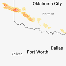
Oklahoma
| Local Time | Report Details |
|---|---|
| 4:23 PM CDT | Half Dollar sized hail reported near Buffalo, OK, 41.5 miles NNW of Woodward, OK, half dollar hail. |
| 4:39 PM CDT | Half Dollar sized hail reported near Buffalo, OK, 40.1 miles NNW of Woodward, OK |
| 4:45 PM CDT | Golf Ball sized hail reported near Buffalo, OK, 40.4 miles NNW of Woodward, OK |
| 5:10 PM CDT | Ping Pong Ball sized hail reported near Buffalo, OK, 37.8 miles NNW of Woodward, OK, reported via spotter network. |
| 5:46 PM CDT | Hen Egg sized hail reported near Freedom, OK, 35.8 miles NNE of Woodward, OK, reported via spotter network. |
| 5:50 PM CDT | Quarter sized hail reported near Freedom, OK, 31.7 miles NNE of Woodward, OK |
| 5:57 PM CDT | Oklahoma mesonet measured 58 mph wind gust in beaver county OK, 49.3 miles WNW of Woodward, OK |
| 6:03 PM CDT | Half Dollar sized hail reported near Laverne, OK, 42.1 miles WNW of Woodward, OK, report received via spotter network. |
| 6:04 PM CDT | Golf Ball sized hail reported near Freedom, OK, 31.8 miles NNE of Woodward, OK |
| 6:04 PM CDT | Tennis Ball sized hail reported near Freedom, OK, 29.2 miles NNE of Woodward, OK, tennis ball sized hail reported. |
| 6:10 PM CDT | Golf Ball sized hail reported near Laverne, OK, 40.1 miles WNW of Woodward, OK, report received via twitter |
| 6:19 PM CDT | Tennis Ball sized hail reported near Freedom, OK, 31.1 miles NNE of Woodward, OK |
| 6:30 PM CDT | Golf Ball sized hail reported near Freedom, OK, 30.8 miles NNE of Woodward, OK |
| 6:39 PM CDT | Quarter sized hail reported near Laverne, OK, 34.2 miles NW of Woodward, OK |
| 6:45 PM CDT | Storm damage reported in woodward county OK, 25.3 miles NE of Woodward, OK |
| 7:05 PM CDT | Storm damage reported in woodward county OK, 25.3 miles NE of Woodward, OK |
| 7:15 PM CDT | Hen Egg sized hail reported near Waynoka, OK, 29.3 miles NE of Woodward, OK |
| 7:25 PM CDT | Storm damage reported in woods county OK, 42.3 miles ENE of Woodward, OK |
| 7:39 PM CDT | Half Dollar sized hail reported near Waynoka, OK, 31.1 miles ENE of Woodward, OK |
| 7:49 PM CDT | Tennis Ball sized hail reported near Waynoka, OK, 36.3 miles ENE of Woodward, OK |
| 7:50 PM CDT | Storm damage reported in woods county OK, 42.3 miles ENE of Woodward, OK |
| 7:55 PM CDT | Golf Ball sized hail reported near Aline, OK, 38.9 miles E of Woodward, OK |
| 8:00 PM CDT | Storm damage reported in beckham county OK, 57.4 miles NNE of Childress, TX |
| 8:05 PM CDT | Tea Cup sized hail reported near Erick, OK, 57.2 miles NNE of Childress, TX, ibhs feild hail study. |
| 8:08 PM CDT | Tennis Ball sized hail reported near Erick, OK, 55.3 miles NNE of Childress, TX |
| 8:08 PM CDT | Baseball sized hail reported near Erick, OK, 56.6 miles NNE of Childress, TX |
| 8:10 PM CDT | Quarter sized hail reported near Carmen, OK, 52.1 miles ENE of Woodward, OK |
| 8:13 PM CDT | Golf Ball sized hail reported near Sayre, OK, 66.2 miles NNE of Childress, TX |
| 8:15 PM CDT | Storm damage reported in beckham county OK, 57.4 miles NNE of Childress, TX |
| 8:25 PM CDT | Golf Ball sized hail reported near Sayre, OK, 68.5 miles NNE of Childress, TX |
| 8:26 PM CDT | 3 east of delhi in beckham county OK, 61.4 miles NNE of Childress, TX |
| 8:48 PM CDT | Quarter sized hail reported near Mooreland, OK, 10.5 miles E of Woodward, OK |
| 8:55 PM CDT | Quarter sized hail reported near Mooreland, OK, 10.5 miles E of Woodward, OK |
| 9:02 PM CDT | Quarter sized hail reported near Ringwood, OK, 64.7 miles E of Woodward, OK |
| 9:05 PM CDT | Golf Ball sized hail reported near Ringwood, OK, 63 miles E of Woodward, OK |
| 9:15 PM CDT | Half Dollar sized hail reported near Sayre, OK, 71.2 miles NE of Childress, TX |
| 9:24 PM CDT | Quarter sized hail reported near Lahoma, OK, 70.9 miles NNW of Oklahoma City, OK |
| 9:24 PM CDT | Storm damage reported in washita county OK, 73.2 miles SSE of Woodward, OK |
| 9:25 PM CDT | Storm damage reported in grant county OK, 65.9 miles SSW of Wichita, KS |
| 9:43 PM CDT | Quarter sized hail reported near Drummond, OK, 67.8 miles NNW of Oklahoma City, OK |
| 9:46 PM CDT | Quarter sized hail reported near Enid, OK, 67.1 miles NNW of Oklahoma City, OK |
| 9:46 PM CDT | Half Dollar sized hail reported near Hobart, OK, 75.3 miles ENE of Childress, TX |
| 9:46 PM CDT | Storm damage reported in garfield county OK, 67.1 miles NNW of Oklahoma City, OK |
| 9:50 PM CDT | Golf Ball sized hail reported near Enid, OK, 63.2 miles NNW of Oklahoma City, OK |
| 9:51 PM CDT | Quarter sized hail reported near Hobart, OK, 76.1 miles ENE of Childress, TX |
| 9:55 PM CDT | Kbkn awos in kay county OK, 64.6 miles S of Wichita, KS |
| 10:50 PM CDT | Half Dollar sized hail reported near Goltry, OK, 69.6 miles E of Woodward, OK, highway 45 and e370 rd. |
| 11:15 PM CDT | Quarter sized hail reported near Carrier, OK, 73.2 miles NNW of Oklahoma City, OK |
| 11:17 PM CDT | Golf Ball sized hail reported near Lahoma, OK, 70.4 miles NNW of Oklahoma City, OK, reported in green valley just east of lahoma |
| 11:19 PM CDT | Half Dollar sized hail reported near Lahoma, OK, 70.9 miles NNW of Oklahoma City, OK, along highway 412 |
| 11:19 PM CDT | Golf Ball sized hail reported near Cache, OK, 50.2 miles N of Wichita Falls, TX |
| 11:55 PM CDT | Storm damage reported in comanche county OK, 61.3 miles N of Wichita Falls, TX |
| 12:09 AM CDT | Storm damage reported in stephens county OK, 59.2 miles NNE of Wichita Falls, TX |
| 12:30 AM CDT | Storm damage reported in stephens county OK, 60.7 miles NE of Wichita Falls, TX |
| 1:07 AM CDT | Tops of a few trees in streets in garvin county OK, 59.1 miles S of Oklahoma City, OK |
| 1:23 AM CDT | Scattered trees down in town in muskogee county OK, 29.1 miles SE of Tulsa, OK |
| 1:30 AM CDT | Storm damage reported in muskogee county OK, 33.9 miles SE of Tulsa, OK |
South Carolina
| Local Time | Report Details |
|---|---|
| 5:45 PM EDT | Twitter report received of trees down on highway 17 in newberry county SC, 61.1 miles ESE of Greenville, SC |
Texas
| Local Time | Report Details |
|---|---|
| 5:13 PM CDT | Quarter sized hail reported near Miami, TX, 75.1 miles ENE of Amarillo, TX, hail ranging from dime to quarter size reported. |
| 5:25 PM CDT | Golf Ball sized hail reported near Booker, TX, 57.4 miles W of Woodward, OK, picture received of golf ball size hail. |
| 5:31 PM CDT | Baseball sized hail reported near Miami, TX, 74.5 miles ENE of Amarillo, TX, baseball size hail reported. |
| 5:32 PM CDT | Golf Ball sized hail reported near , , 75.6 miles ENE of Amarillo, TX |
| 5:35 PM CDT | Hen Egg sized hail reported near Mobeetie, TX, 77 miles N of Childress, TX, hail from golf ball to hen egg size fell for 45 minutes. report received via facebook messanger. |
| 5:44 PM CDT | Half Dollar sized hail reported near Darrouzett, TX, 51.9 miles W of Woodward, OK |
| 5:57 PM CDT | Quarter sized hail reported near Mobeetie, TX, 73.2 miles N of Childress, TX, report received from spotter network. |
| 6:17 PM CDT | Quarter sized hail reported near Wheeler, TX, 67.6 miles N of Childress, TX, report received via spotter network |
| 6:20 PM CDT | Tea Cup sized hail reported near Wheeler, TX, 69.8 miles N of Childress, TX, report received via twitter. |
| 6:45 PM CDT | Tea Cup sized hail reported near Wheeler, TX, 69.8 miles N of Childress, TX, reported relayed from broadcast media. |
| 6:48 PM CDT | Baseball sized hail reported near Wheeler, TX, 69.8 miles N of Childress, TX, broadcast media relayed report of baseball size hail. |
| 4:15 AM CDT | Trees down near hwy 271 at hwy 2648 in lamar county TX, 55.6 miles SE of Atoka, OK |
South Dakota
| Local Time | Report Details |
|---|---|
| 5:24 PM CDT | Storm damage reported in hughes county SD, 1.5 miles E of Pierre, SD |
Colorado
| Local Time | Report Details |
|---|---|
| 4:35 PM MDT | Golf Ball sized hail reported near Joes, CO, 28.2 miles S of Yuma, CO, report received by cocorahs report. |
| 4:37 PM MDT | Golf Ball sized hail reported near Joes, CO, 28.2 miles S of Yuma, CO, ping pong to golfball size hail occurring at time of the report. |
| 6:38 PM MDT | Quarter sized hail reported near Burlington, CO, 56 miles SSE of Yuma, CO, brief period of nickel to quarter size hail 6 miles north of burlington at 638 pm mdt. |
Wisconsin
| Local Time | Report Details |
|---|---|
| 6:15 PM CDT | 12 inch tree snapped in hal in barron county WI, 84.4 miles ENE of Minneapolis, MN |
| 6:20 PM CDT | Power outage east side of rice lak in barron county WI, 82.5 miles ENE of Minneapolis, MN |
| 7:00 PM CDT | Large tree dow in sawyer county WI, 67.9 miles SSE of Duluth, MN |
Indiana
| Local Time | Report Details |
|---|---|
| 7:20 PM EDT | Portion of a hay field was flattened. a nearby barn suffered damag in st. joseph county IN, 68.5 miles WNW of Fort Wayne, IN |
Florida
| Local Time | Report Details |
|---|---|
| 7:55 PM EDT | Wsvn shared viewer report of tree damage along sw 296th st near us-1 in homestead. examination of the video and radar determined that the tree damage occurred from an o in miami-dade county FL, 21.1 miles SW of Miami, FL |
| 8:30 PM EDT | Wsvn shared viewer report of tree damage along sw 296th st near us-1 in homestead. examination of the video and radar determined that the tree damage occurred from an o in miami-dade county FL, 21.1 miles SW of Miami, FL |
Missouri
| Local Time | Report Details |
|---|---|
| 6:57 PM CDT | 8" - 10" bradford pear and another 12" - 14" tree snappe in platte county MO, 10.4 miles NNW of Kansas City, MO |
Connect with Interactive Hail Maps