

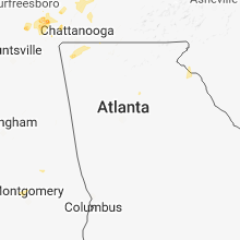
Hail Map for Thursday, May 31, 2018

Number of Impacted Households on 5/31/2018
0
Impacted by 1" or Larger Hail
0
Impacted by 1.75" or Larger Hail
0
Impacted by 2.5" or Larger Hail
Square Miles of Populated Area Impacted on 5/31/2018
0
Impacted by 1" or Larger Hail
0
Impacted by 1.75" or Larger Hail
0
Impacted by 2.5" or Larger Hail


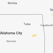


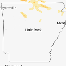


Cities Most Affected by Hail Storms of 5/31/2018
| Hail Size | Demographics of Zip Codes Affected | ||||||
|---|---|---|---|---|---|---|---|
| City | Count | Average | Largest | Pop Density | House Value | Income | Age |
| Roundup, MT | 8 | 2.31 | 4.25 | 4 | $55k | $25.4k | 48.9 |
| Forsyth, MO | 4 | 2.00 | 2.75 | 71 | $87k | $30.5k | 47.9 |
| Branson, MO | 3 | 2.50 | 2.50 | 367 | $114k | $33.6k | 39.8 |
| Irondale, MO | 1 | 2.50 | 2.50 | 41 | $44k | $31.2k | 38.4 |
| Viburnum, MO | 1 | 1.75 | 1.75 | 103 | $53k | $33.1k | 40.2 |
| Eminence, MO | 1 | 1.75 | 1.75 | 4 | $51k | $23.0k | 46.3 |
| Melstone, MT | 1 | 1.75 | 1.75 | 0 | $55k | $31.0k | 47.1 |
| Paul, ID | 1 | 1.75 | 1.75 | 11 | $84k | $32.7k | 34.8 |
Hail and Wind Damage Spotted on 5/31/2018
Filter by Report Type:Hail ReportsWind Reports
States Impacted
Missouri, Tennessee, Illinois, Kentucky, Indiana, Idaho, Montana, West Virginia, Ohio, North Dakota, Georgia, South Carolina, North Carolina, Virginia, Wyoming, ArkansasMissouri
| Local Time | Report Details |
|---|---|
| 7:52 AM CDT | Power lines dow in crawford county MO, 19.8 miles ENE of Salem, MO |
| 7:52 AM CDT | Multiple trees down at the intersection of highway 49 and route v... some blocking the roa in crawford county MO, 20.6 miles ENE of Salem, MO |
| 8:15 AM CDT | Trees and tree limbs dow in washington county MO, 44.9 miles ENE of Salem, MO |
| 8:30 AM CDT | Small tree limbs down. also in bonne terre... bismarck... and park hills area in st. francois county MO, 58.7 miles NW of Cape Girardeau, MO |
| 10:15 AM CDT | Tree blown onto house on lee street. additional trees blown down in town and power lines down in town. some power outages and numerous tree limbs dow in scott county MO, 29.2 miles S of Cape Girardeau, MO |
| 4:34 PM CDT | Trees are down in birch tre in shannon county MO, 44.7 miles S of Salem, MO |
| 4:34 PM CDT | Ping Pong Ball sized hail reported near Birch Tree, MO, 44 miles S of Salem, MO, corrects previous hail report from 1 nw birch tree. trooper reports ping-pong sized hail on highway 60 just west of birch tree//shannon county. corrected report source. |
| 4:40 PM CDT | Tennis Ball sized hail reported near Branson, MO, 38.8 miles S of Springfield, MO, estimated as large as tennis ball size hail fell for about 5 minutes starting around 4:40 pm. via facebook picture. |
| 4:40 PM CDT | Tennis Ball sized hail reported near Branson, MO, 36 miles SSE of Springfield, MO, corrects time from previous hail report from rockaway beach. via facebook. public reported from rockaway beach. some pieces fell as big as tennis balls. around 5 pm. la |
| 4:40 PM CDT | Corrects previous tstm wnd dmg report from rockaway beach. tree damage in rockaway beach. on 176 in the downtown area. added location detail in taney county MO, 35.8 miles SSE of Springfield, MO |
| 4:40 PM CDT | Half Dollar sized hail reported near Branson, MO, 35.3 miles S of Springfield, MO, half dollar size hail being reported 1 1/2 miles south of f and 65. |
| 4:40 PM CDT | Golf Ball sized hail reported near Forsyth, MO, 37 miles SSE of Springfield, MO, golfball size hail. |
| 4:40 PM CDT | Golf Ball sized hail reported near Forsyth, MO, 38.5 miles SSE of Springfield, MO, golf ball size hail at forsyth mo 17;40 till 17:45 wind estimated at 45 to 50 knots. |
| 4:40 PM CDT | Forsyth fire department reported a roof collapse due to heavy rain fall and a weaken structure. delayed repor in taney county MO, 37 miles SSE of Springfield, MO |
| 4:43 PM CDT | Golf Ball sized hail reported near Forsyth, MO, 37.3 miles SSE of Springfield, MO, golfball size hail. |
| 4:45 PM CDT | Quarter sized hail reported near West Plains, MO, 66.4 miles SSW of Salem, MO, social media report. |
| 4:50 PM CDT | Baseball sized hail reported near Forsyth, MO, 37 miles SSE of Springfield, MO, measured baseball size hail. via media facebook. |
| 5:00 PM CDT | Tennis Ball sized hail reported near Branson, MO, 36 miles SSE of Springfield, MO, via facebook. public reported from rockaway beach. some pieces fell as big as tennis balls. around 5 pm. lasted about 10-15 min. |
| 5:23 PM CDT | Quarter sized hail reported near Fremont, MO, 51.9 miles SSE of Salem, MO, quarter size hail reported near intersection of highway 7 and highway 60. |
| 5:44 PM CDT | Quarter sized hail reported near Thornfield, MO, 49 miles SE of Springfield, MO, quarter sized hail and high winds in thornfield. |
| 5:45 PM CDT | Quarter sized hail reported near Thayer, MO, 74.3 miles S of Salem, MO, quarter size hail 5-31-18 17:45 3 mi ne of thayer on hwy 19. via contact. |
| 5:53 PM CDT | Quarter sized hail reported near Thornfield, MO, 48.6 miles SE of Springfield, MO, foil reports no wind and light rain. at south d hwy and cr 863 40-50 mph winds and the hail is intermittent pea sized to quarter sized. |
| 6:32 PM CDT | Golf Ball sized hail reported near Eminence, MO, 34.9 miles SSE of Salem, MO, golf ball size hail. |
| 6:37 PM CDT | Corrects previous tstm wnd dmg report from 2 e licking. minor damage (small outbuilding... a/c unit... outdoor furniture) and no injuries. no tree damage. delayed repor in texas county MO, 18.2 miles WSW of Salem, MO |
| 6:40 PM CDT | Quarter sized hail reported near Mansfield, MO, 39.7 miles E of Springfield, MO, nickle to quarter size hail very heavy lighting strikes. hwy 5 dougles and mansfield lin. |
| 7:21 PM CDT | Quarter sized hail reported near Viburnum, MO, 22.3 miles ENE of Salem, MO |
| 7:24 PM CDT | Golf Ball sized hail reported near Viburnum, MO, 22.3 miles ENE of Salem, MO |
| 7:31 PM CDT | Tennis Ball sized hail reported near Irondale, MO, 43.6 miles ENE of Salem, MO |
| 8:06 PM CDT | Quarter sized hail reported near Gainesville, MO, 63.1 miles SE of Springfield, MO, heavy rain and pea to quarter size reported at the ozark county ambulance base in gainesville mo. |
| 8:58 PM CDT | Quarter sized hail reported near Hartville, MO, 43.2 miles E of Springfield, MO, quarter size hail. |
| 9:22 PM CDT | Late report...trees and power lines down along highway 274 in cape girardeau county MO, 19.9 miles WSW of Cape Girardeau, MO |
| 9:35 PM CDT | Trees down and power outages in scott county MO, 14 miles S of Cape Girardeau, MO |
| 9:50 PM CDT | Tree blown over road on highway h near county road 506. numerous power outages also reported within the county as storms rolled throug in scott county MO, 18.8 miles S of Cape Girardeau, MO |
| 9:51 PM CDT | Large tree fell on a doghouse killing the dog. time approximate. off county road county road 32 in ozark county MO, 68.8 miles SE of Springfield, MO |
| 9:51 PM CDT | Tree and vehicle damage reported near intersection of hwy t and ra. small hail also reporte in wayne county MO, 47.2 miles WSW of Cape Girardeau, MO |
| 10:15 PM CDT | Tree blown onto house on lee street. additional trees blown down in town and power lines down in town. some power outages and numerous tree limbs dow in scott county MO, 29.2 miles S of Cape Girardeau, MO |
| 10:32 PM CDT | Numerous tree limbs down. 2 to 3 inch diamete in mississippi county MO, 37.2 miles SSE of Cape Girardeau, MO |
| 10:45 PM CDT | Numerous tree limbs down. 2 to 3 inch diamete in mississippi county MO, 37.2 miles SSE of Cape Girardeau, MO |
Tennessee
| Local Time | Report Details |
|---|---|
| 8:19 AM CDT | Tree was downed across county highway 50 near henshaw roa in moore county TN, 62 miles WNW of Chattanooga, TN |
| 3:06 PM CDT | Received a report of a tree on a house in the algood area. the tree took some powerlines down to in putnam county TN, 74.8 miles E of Nashville, TN |
| 3:54 PM CDT | Tree down at union camp and royd roa in macon county TN, 51.7 miles ENE of Nashville, TN |
| 4:06 PM CDT | Several reports of trees and limbs down. approximately 500 people without powe in macon county TN, 57.5 miles ENE of Nashville, TN |
| 5:40 PM EDT | Several trees down south of huntsville... t in scott county TN, 42.5 miles NW of Knoxville, TN |
| 5:00 PM CDT | A tree reported down near lantana road and laurel circle. time estimated by rada in cumberland county TN, 62.7 miles W of Knoxville, TN |
| 6:25 PM EDT | Multiple reports of trees down across the count in campbell county TN, 30.6 miles NNW of Knoxville, TN |
| 6:45 PM EDT | Several trees dow in hawkins county TN, 51.6 miles WSW of Bristol, TN |
| 7:05 PM EDT | Trees and power lines down county-wide in union count in union county TN, 20.9 miles NNE of Knoxville, TN |
| 7:15 PM EDT | Several trees and power lines down near the lakeshore dr are in grainger county TN, 31 miles NE of Knoxville, TN |
| 7:20 PM EDT | A few trees dow in unicoi county TN, 28.6 miles SSW of Bristol, TN |
| 7:30 PM EDT | Several trees dow in greene county TN, 50.9 miles ENE of Knoxville, TN |
| 7:35 PM EDT | Several trees down and power lines dow in grainger county TN, 31 miles NE of Knoxville, TN |
| 6:36 PM CDT | Ping Pong Ball sized hail reported near Hartsville, TN, 42 miles ENE of Nashville, TN, facebook photos showed hail up to ping pong ball size fell on middle fork road between highway 141 and highway 10. |
| 7:46 PM EDT | Trees and power lines down across the count in jefferson county TN, 26.5 miles ENE of Knoxville, TN |
| 7:05 PM CDT | Jackson county 911 center reported a few trees and power lines down with some roadways blocked in the county along with minor floodin in jackson county TN, 64.4 miles ENE of Nashville, TN |
| 8:19 PM CDT | Corrects previous tstm wnd dmg report from 2 sw lynchburg. tree was downed across county highway 50 near henshaw roa in moore county TN, 62 miles WNW of Chattanooga, TN |
| 8:30 PM CDT | Quarter sized hail reported near Winchester, TN, 57.1 miles WNW of Chattanooga, TN, hail appeared from picture to be in the dime to quarter in size. thanks wfo ohx for forwarding this. |
| 1:36 AM CDT | Storm spotter reports trees and power lines down across roads countywide across haywood count in haywood county TN, 54.4 miles NE of Memphis, TN |
Illinois
| Local Time | Report Details |
|---|---|
| 9:42 AM CDT | Many tree limbs down. several shingles off a hous in perry county IL, 54.4 miles N of Cape Girardeau, MO |
| 9:45 AM CDT | Trees on power lines in the northern and southern parts of jackson count in jackson county IL, 43.3 miles N of Cape Girardeau, MO |
| 9:53 AM CDT | Multiple trees/power lines down across perry county and power outages reporte in perry county IL, 50.9 miles NNE of Cape Girardeau, MO |
| 9:55 AM CDT | Trees down... one on a house. from local media on social medi in randolph county IL, 44.3 miles SE of Saint Louis, MO |
| 10:00 AM CDT | Trees blown dow in washington county IL, 48.4 miles ESE of Saint Louis, MO |
| 10:00 AM CDT | Numerous limbs down. gutters blown off a house. power outage in franklin county IL, 60.7 miles NNE of Cape Girardeau, MO |
| 10:13 AM CDT | Scatttered tree damage with limbs down between woodlawn and mt. verno in jefferson county IL, 73.1 miles ESE of Saint Louis, MO |
| 10:15 AM CDT | Measured at mt. vernon aipor in jefferson county IL, 74.4 miles WNW of Evansville, IN |
| 10:23 AM CDT | Power outages scattered across the county. including christopher and mulkeytown. also tree down on highway near elmwood cemetar in franklin county IL, 53.4 miles NNE of Cape Girardeau, MO |
| 10:23 AM CDT | Trees and power lines down across the county. including galatia and carrier mill in saline county IL, 57.9 miles W of Evansville, IN |
| 10:30 AM CDT | Trees down making rt 142 impassable near dal in hamilton county IL, 52.3 miles W of Evansville, IN |
| 10:35 AM CDT | Trees... tree limbs... and power lines dow in marion county IL, 70.9 miles E of Saint Louis, MO |
| 10:42 AM CDT | Trees and power lines down. wind estimated at 40 mp in white county IL, 34 miles WNW of Evansville, IN |
| 10:47 AM CDT | Pole barn blown ove in marion county IL, 70.5 miles SSW of Mattoon, IL |
| 10:50 AM CDT | Wind speeds 40-45 mph with gusts above 60 mph estimated. trees and power lines down across county. blew doors open on health dept. generators are being utilize in wayne county IL, 51.9 miles WNW of Evansville, IN |
| 10:55 AM CDT | Small trees and power lines down. wind estimated at 40 mp in white county IL, 34 miles WNW of Evansville, IN |
| 10:55 AM CDT | Trees down and tree fallen on hous in marion county IL, 66.1 miles SSW of Mattoon, IL |
| 10:56 AM CDT | Wind gust near interstate 6 in hamilton county IL, 56.3 miles WNW of Evansville, IN |
| 11:01 AM CDT | Numerous trees and powerlines down. some large trees downed on houses. time estimated from rada in clay county IL, 56.3 miles S of Mattoon, IL |
| 11:02 AM CDT | A couple of small limbs down in the city of albio in edwards county IL, 38.8 miles NW of Evansville, IN |
| 11:03 AM CDT | Multiple trees down. reports of trees on home in clay county IL, 56.3 miles S of Mattoon, IL |
| 11:03 AM CDT | Multiple trees dow in clay county IL, 59.8 miles SSW of Mattoon, IL |
| 11:08 AM CDT | Trees dow in fayette county IL, 49.3 miles SSW of Mattoon, IL |
| 11:10 AM CDT | Large tree dow in edwards county IL, 35.9 miles NW of Evansville, IN |
| 11:12 AM CDT | Storm damage reported in richland county IL, 55.1 miles SSE of Mattoon, IL |
| 11:15 AM CDT | 8-inch limb ripped off tree in effingham county IL, 39.7 miles SSW of Mattoon, IL |
| 11:20 AM CDT | Tree fell on a house in allendal in wabash county IL, 39 miles NNW of Evansville, IN |
| 11:20 AM CDT | Small tree limbs down. time estimated from rada in effingham county IL, 41.6 miles SSW of Mattoon, IL |
| 11:22 AM CDT | Storm damage reported in clay county IL, 51.7 miles S of Mattoon, IL |
| 11:22 AM CDT | Storm damage reported in clay county IL, 51.7 miles S of Mattoon, IL |
| 11:23 AM CDT | Numerous trees reported down throughout the city. time estimated by rada in lawrence county IL, 53.7 miles NNW of Evansville, IN |
| 11:23 AM CDT | Two-inch diameter tree branch about 10 to 12 inches long was blown down in effingham county IL, 37.3 miles SSW of Mattoon, IL |
| 11:28 AM CDT | Numerous trees reported down around the city. time estimated by rada in lawrence county IL, 51.7 miles NNW of Evansville, IN |
| 11:32 AM CDT | Numerous trees and power lines reported downed throughout the city. time estimated by rada in lawrence county IL, 52.4 miles N of Evansville, IN |
| 11:35 AM CDT | Crawford county sheriff is reporting around 30 calls of damage throughout the county. tree damage was the main report type. time of occurrence was between 1135-115 in crawford county IL, 47.1 miles SE of Mattoon, IL |
| 11:45 AM CDT | *** 1 inj *** semi-trailer blown ove in jasper county IL, 42.4 miles SSE of Mattoon, IL |
| 11:58 AM CDT | Trees down making rt 142 impassable near dal in hamilton county IL, 52.3 miles W of Evansville, IN |
| 2:10 PM CDT | Large tree limb blown down. photo sent via facebook. time estimate in will county IL, 34.5 miles WSW of Chicago, IL |
| 2:53 PM CDT | Quarter sized hail reported near Cairo, IL, 29 miles SE of Cape Girardeau, MO, at the cairo il fire dept. |
| 3:42 PM CDT | One power pole blown dow in de witt county IL, 40.3 miles SE of Peoria, IL |
| 3:42 PM CDT | One power pole blown dow in richland county IL, 46.3 miles S of Mattoon, IL |
| 3:42 PM CDT | Several power lines blown down in de witt county IL, 41.4 miles SE of Peoria, IL |
| 4:15 PM CDT | Tree limb blown down on highway 54 east of power plant in de witt county IL, 53.2 miles NNW of Mattoon, IL |
| 5:30 PM CDT | 20 power poles snapped off and lot of corn laid down. near the intersection of 1425n and 2300e. from county emergency manage in champaign county IL, 45 miles NNE of Mattoon, IL |
| 6:07 PM CDT | Large tree down across road near main street and michigan ave... on danville east side. from county emergency manage in vermilion county IL, 60.7 miles NE of Mattoon, IL |
| 6:10 PM CDT | 4 trees down. from county emergency manage in vermilion county IL, 60.5 miles NE of Mattoon, IL |
| 7:55 PM CDT | Half Dollar sized hail reported near Broughton, IL, 45.2 miles W of Evansville, IN, reported in the community of gosseett. |
| 8:01 PM CDT | Ping Pong Ball sized hail reported near Norris City, IL, 41.8 miles W of Evansville, IN, ping pong size hail. |
| 8:04 PM CDT | Quarter sized hail reported near Norris City, IL, 42.6 miles W of Evansville, IN, quarter size hail reported. |
Kentucky
| Local Time | Report Details |
|---|---|
| 11:48 AM EDT | Downed tree on some power lines that have hit a gas line causing major gas lea in woodford county KY, 46.5 miles NW of Irvine, KY |
| 11:10 AM CDT | A tree was reported over a road and another large tree downed in union count in union county KY, 27.9 miles SW of Evansville, IN |
| 11:30 AM CDT | Tree dow in henderson county KY, 9.5 miles S of Evansville, IN |
| 11:35 AM CDT | At least a half dozen trees down and power outages reported. pea size hail also reporte in henderson county KY, 9.5 miles S of Evansville, IN |
| 1:20 PM EDT | Downed tree limbs fell on several utility line in anderson county KY, 43.5 miles E of Louisville, KY |
| 1:29 PM EDT | Tree down on 460 in menifee county KY, 25.9 miles NE of Irvine, KY |
| 1:35 PM EDT | Tree down on highway 7 in menifee county KY, 28.2 miles ENE of Irvine, KY |
| 12:43 PM CDT | Tree blocking roa in hancock county KY, 42.2 miles E of Evansville, IN |
| 12:45 PM CDT | Quarter sized hail reported near Owensboro, KY, 28.5 miles ESE of Evansville, IN, reported along the daviess hancock county line. |
| 1:51 PM EDT | Tree down on highway 1812...blocking one lan in wolfe county KY, 26.7 miles E of Irvine, KY |
| 2:05 PM EDT | Several trees reported down in eastern part of the county - mainly in the eastern half of the count in meade county KY, 19.2 miles WSW of Louisville, KY |
| 1:15 PM CDT | Quarter sized hail reported near Benton, KY, 50.2 miles N of Mc Kenzie, TN |
| 2:25 PM EDT | Reported at scott county kentucky numerous reports of trees down county wid in scott county KY, 52.4 miles NW of Irvine, KY |
| 2:27 PM EDT | Trees dow in jefferson county KY, 12 miles NW of Louisville, KY |
| 2:29 PM EDT | Trees dow in jefferson county KY, 18.8 miles NNW of Louisville, KY |
| 2:30 PM EDT | Reported at broadway and hancock louisville large tree blocking roa in jefferson county KY, 17.4 miles N of Louisville, KY |
| 2:32 PM EDT | Trees on a buildin in jefferson county KY, 14.4 miles NNW of Louisville, KY |
| 2:33 PM EDT | Trees on a buildin in jefferson county KY, 19.9 miles NNW of Louisville, KY |
| 2:33 PM EDT | Trees down west pages at devonshir in jefferson county KY, 12.9 miles NW of Louisville, KY |
| 2:33 PM EDT | Corrected time. tree down on vehicle along goss av in jefferson county KY, 16.8 miles N of Louisville, KY |
| 2:34 PM EDT | Trees down dubourg avenue at dixie highwa in jefferson county KY, 16 miles NNW of Louisville, KY |
| 2:34 PM EDT | Trees down on churchman avenu in jefferson county KY, 13.8 miles NNW of Louisville, KY |
| 2:34 PM EDT | Trees down on south first stree in jefferson county KY, 16.9 miles N of Louisville, KY |
| 2:34 PM EDT | Corrected time. trees down 12th street and muhammad al in jefferson county KY, 18.3 miles N of Louisville, KY |
| 2:35 PM EDT | Corrects previous non-tstm wnd gst report from louisville intl airport. asos station sdf... louisville intl airpor in jefferson county KY, 12.6 miles N of Louisville, KY |
| 2:35 PM EDT | Someone's porch was completely destoryed. roof shingles on road and in yards. two trees on top of two different house in jefferson county KY, 16.3 miles N of Louisville, KY |
| 2:35 PM EDT | Saws report from air traffic controller at bowman fiel in jefferson county KY, 17 miles N of Louisville, KY |
| 2:36 PM EDT | Roof blown off at angler's outpos in bullitt county KY, 4.7 miles NNE of Louisville, KY |
| 2:38 PM EDT | Trees and power lines down on armstrong mill and delong in lexington. lines down across a car with people insid in fayette county KY, 31.6 miles NW of Irvine, KY |
| 2:38 PM EDT | Corrected time. trees down along river road just ne of downtow in jefferson county KY, 19.5 miles N of Louisville, KY |
| 2:40 PM EDT | Tree down on power lines on lost creek road...road is closed. time estimated off of rada in perry county KY, 46.3 miles ESE of Irvine, KY |
| 2:41 PM EDT | Tree down on highway 42 in clay county KY, 31.8 miles SSE of Irvine, KY |
| 2:41 PM EDT | Trees down highway 42 and covered bridge roa in jefferson county KY, 25.6 miles NNE of Louisville, KY |
| 2:41 PM EDT | Several trees downed on halls hill road off ky-32 in oldham county KY, 28.7 miles NNE of Louisville, KY |
| 2:43 PM EDT | Trees down blankenbaker lan in jefferson county KY, 21 miles N of Louisville, KY |
| 2:43 PM EDT | Trees reported blocking csx railroad line between crestwood and peewee valle in oldham county KY, 26.3 miles NNE of Louisville, KY |
| 2:44 PM EDT | Reported at hikes point... louisvile tree down on garag in jefferson county KY, 17.4 miles NNE of Louisville, KY |
| 2:45 PM EDT | Trees down at multiple locations along interstate 7 in oldham county KY, 35.3 miles NE of Louisville, KY |
| 2:49 PM EDT | Trees down at anchorage school and anchorage presbyterian churc in jefferson county KY, 21.7 miles NNE of Louisville, KY |
| 2:50 PM EDT | Large tree limb broke out window of semi tractor at mile marker 24 of i-71 southboun in oldham county KY, 35.6 miles NE of Louisville, KY |
| 2:52 PM EDT | Trees down on highway 421... both north and south of bedfor in trimble county KY, 48 miles NNE of Louisville, KY |
| 2:56 PM EDT | Storm damage reported in henry county KY, 37.2 miles NE of Louisville, KY |
| 3:02 PM EDT | Trees down near pendleto in henry county KY, 39.4 miles NE of Louisville, KY |
| 3:10 PM EDT | Several trees and limbs reported down in the northeast part of the count in nelson county KY, 24.6 miles ESE of Louisville, KY |
| 3:11 PM EDT | Reported at goss ave... louisville tree down on vehicle along goss av in jefferson county KY, 16.8 miles N of Louisville, KY |
| 3:12 PM EDT | Large tree across road 232 eldorado ave in bueche in jefferson county KY, 14.7 miles NNE of Louisville, KY |
| 3:12 PM EDT | Trees down in the pleasureville and bethlehem are in henry county KY, 43.1 miles NE of Louisville, KY |
| 3:17 PM EDT | Trees dow in henry county KY, 49.4 miles SW of Cincinnati, OH |
| 3:24 PM EDT | Trees downe in owen county KY, 41.2 miles SSW of Cincinnati, OH |
| 3:25 PM EDT | More than 2 dozen reports of trees down across the southern part of the county from frankfort sout in franklin county KY, 47.8 miles ENE of Louisville, KY |
| 3:27 PM EDT | Trees down on route 127 and also 45 in gallatin county KY, 32.2 miles SSW of Cincinnati, OH |
| 3:27 PM EDT | Asos station fft... capital city airpor in franklin county KY, 46.5 miles ENE of Louisville, KY |
| 3:30 PM EDT | Trees downed on loretto roa in marion county KY, 31.7 miles SE of Louisville, KY |
| 3:35 PM EDT | Storm damage reported in owen county KY, 40.4 miles SSW of Cincinnati, OH |
| 3:38 PM EDT | Trees down along river road just ne of downtow in jefferson county KY, 19.5 miles N of Louisville, KY |
| 3:39 PM EDT | Asos station lex... lexington blue grass airpor in fayette county KY, 41.9 miles NW of Irvine, KY |
| 3:39 PM EDT | Two 6 inch diameter trees snapped near palomar shopping cente in fayette county KY, 38.6 miles WNW of Irvine, KY |
| 3:40 PM EDT | Numerous trees downed in lebanon... and in other parts of marion count in marion county KY, 38.1 miles SE of Louisville, KY |
| 3:40 PM EDT | Trees downe in boone county KY, 10.8 miles WSW of Cincinnati, OH |
| 3:45 PM EDT | Siding off of a house. several 6 inch or larger diameter limbs broken off. one power line downe in kenton county KY, 4.6 miles S of Cincinnati, OH |
| 3:55 PM EDT | Tree down blocking hundley lan in marion county KY, 40.2 miles SE of Louisville, KY |
| 3:58 PM EDT | Trees downe in pendleton county KY, 31.6 miles SSE of Cincinnati, OH |
| 3:59 PM EDT | 53 knot gust at blue grass airpor in fayette county KY, 41.5 miles WNW of Irvine, KY |
| 4:00 PM EDT | Gust at ky mesonet sit in harrison county KY, 42.8 miles SSE of Cincinnati, OH |
| 4:14 PM EDT | Trees downe in bracken county KY, 37.6 miles SE of Cincinnati, OH |
| 4:20 PM EDT | Multiple trees dow in nicholas county KY, 47 miles N of Irvine, KY |
| 4:27 PM EDT | A large tree was blown down across the road in the vicinity of cedar lake. the time of the event is estimated from radar dat in fleming county KY, 48 miles N of Irvine, KY |
| 4:32 PM EDT | A large tree limb was reported to have been downed. the time of the event is estimated from rada in powell county KY, 12.1 miles NNE of Irvine, KY |
| 3:43 PM CDT | Tree down in road on joe morris rd near finney r in barren county KY, 66.2 miles NE of Nashville, TN |
| 4:45 PM EDT | One tree was reported to have been blown down along us 25e near pinevill in bell county KY, 56.5 miles NNE of Knoxville, TN |
| 4:50 PM EDT | A couple of trees were reported to have been down in the vicnity of shopvill in pulaski county KY, 43.7 miles SSW of Irvine, KY |
| 4:51 PM EDT | Numerous trees and power lines dow in lewis county KY, 62.5 miles SE of Cincinnati, OH |
| 3:52 PM CDT | Quarter sized hail reported near Paducah, KY, 47 miles ESE of Cape Girardeau, MO, public report via broadcast media |
| 4:55 PM EDT | A tree was reported to have been blown down on bluestone road. the time of the event is estimated from radar dat in rowan county KY, 42.9 miles NE of Irvine, KY |
| 4:00 PM CDT | Numerous limbs dow in ballard county KY, 43 miles ESE of Cape Girardeau, MO |
| 5:04 PM EDT | A tree was blown down onto a powerline. the time of the event is estimated from rada in morgan county KY, 35.9 miles ENE of Irvine, KY |
| 5:05 PM EDT | Numerous trees and power lines dow in lewis county KY, 71 miles NNE of Irvine, KY |
| 4:09 PM CDT | Power line down blocking the road on e hwy 619 near indian caves hil in russell county KY, 74.7 miles SW of Irvine, KY |
| 5:30 PM EDT | A tree was reported to have been blown down. the time of the event is estimated from rada in wayne county KY, 70.8 miles SW of Irvine, KY |
| 5:30 PM EDT | Tree down on highway 26...blocking roa in whitley county KY, 57.8 miles S of Irvine, KY |
| 4:32 PM CDT | Trees down in christian county KY, 64.2 miles NW of Nashville, TN |
| 5:39 PM EDT | A tree was reported to have been blown down. the time of the event is estimated from rada in whitley county KY, 61.1 miles NNW of Knoxville, TN |
| 5:40 PM EDT | Two trees were reported to have been downed. the time of the event is estimated from radar dat in wayne county KY, 76.4 miles SW of Irvine, KY |
| 4:45 PM CDT | Across from 3990 princeton road... or highway 91... tree down and corn laying fla in christian county KY, 65.9 miles NW of Nashville, TN |
| 5:47 PM EDT | A tree was reported to have been downed on taylor lane. the time of the event is estimated from rada in knox county KY, 59.6 miles S of Irvine, KY |
| 5:48 PM EDT | Trees and phone lines were reported to have been downed. the time of the event is based on radar dat in whitley county KY, 55.5 miles NNW of Knoxville, TN |
| 6:00 PM EDT | A large tree was uprooted and fell on top of a hous in boyd county KY, 54.9 miles W of Charleston, WV |
| 5:10 PM CDT | Trees down across intersection of shaw oval road and pilot rock roa in christian county KY, 63.5 miles NNW of Nashville, TN |
| 5:20 PM CDT | Tree fell across power lines along parkview road. area without power. time estimate in christian county KY, 61.5 miles NW of Nashville, TN |
| 5:21 PM CDT | Trees down blocking road near 4510 n greenville roa in christian county KY, 62.3 miles NW of Nashville, TN |
| 5:43 PM CDT | Tree down across nashville road south of chaney's dairy bar in warren county KY, 51 miles NNE of Nashville, TN |
| 5:55 PM CDT | Power lines downed in frankli in simpson county KY, 40.3 miles NNE of Nashville, TN |
| 6:02 PM CDT | Tree downed across rapids roa in simpson county KY, 39.2 miles NNE of Nashville, TN |
| 6:06 PM CDT | Trees down across maysville roa in allen county KY, 52 miles NE of Nashville, TN |
| 9:34 PM EDT | Trees down 12th street and muhammad al in jefferson county KY, 18.3 miles N of Louisville, KY |
| 9:51 PM CDT | Damaging winds with power outages reported in the communit in ballard county KY, 30.5 miles ESE of Cape Girardeau, MO |
| 10:28 PM CDT | Damaging winds with power outages reported in the communit in ballard county KY, 30.5 miles ESE of Cape Girardeau, MO |
Indiana
| Local Time | Report Details |
|---|---|
| 11:30 AM CDT | Trees and power outages mainly on the west side of princeton. trees also down in east mount carme in gibson county IN, 26.4 miles N of Evansville, IN |
| 11:33 AM CDT | Semi truck blown over near interstae 64 and us hwy 41 intersection. also numerous reports of trees and power lines down across count in vanderburgh county IN, 1.3 miles E of Evansville, IN |
| 11:36 AM CDT | Storm damage reported in vanderburgh county IN, 1.3 miles E of Evansville, IN |
| 12:42 PM EDT | Numerous trees down across vincennes. time estimated via rada in knox county IN, 48.6 miles N of Evansville, IN |
| 12:42 PM EDT | Tree down at interection of niblack and main. time estimated via radar. relayed via amateur radi in knox county IN, 46.4 miles N of Evansville, IN |
| 11:45 AM CDT | A house porch collapsed from fallen tree in gibson county IN, 27.6 miles NNE of Evansville, IN |
| 12:45 PM EDT | Estimated 60 mph wind in knox county IN, 48.8 miles N of Evansville, IN |
| 11:45 AM CDT | Late report and time estimated...large tree fell on home near intersection of south 4th and oak. home damage in warrick county IN, 16.8 miles ENE of Evansville, IN |
| 11:47 AM CDT | Tree limbs dow in warrick county IN, 11.5 miles ENE of Evansville, IN |
| 11:58 AM CDT | Trees down making rt 142 impassable near dal in spencer county IN, 33.6 miles ENE of Evansville, IN |
| 1:00 PM EDT | Relayed via amateur radio callsign kc9c in knox county IN, 57.9 miles NNE of Evansville, IN |
| 1:00 PM EDT | 5 foot diameter tree snapped at base along 9th stree in knox county IN, 57.2 miles NNE of Evansville, IN |
| 1:00 PM EDT | 10 inch diameter live tree down at 9th and alexande in knox county IN, 57.1 miles NNE of Evansville, IN |
| 1:11 PM EDT | Reported at 203 w 1st st... huntingburg lines and poles down with fir in dubois county IN, 39.4 miles ENE of Evansville, IN |
| 12:12 PM CDT | Storm damage reported in spencer county IN, 28.9 miles ESE of Evansville, IN |
| 1:15 PM EDT | 12 inch tree covering us 50 between shoals and loogoote in martin county IN, 61.8 miles NE of Evansville, IN |
| 1:18 PM EDT | Car port roof blown off of metal garag in dubois county IN, 52 miles NE of Evansville, IN |
| 1:19 PM EDT | Trees down in city park. relayed via social medi in sullivan county IN, 58.4 miles ESE of Mattoon, IL |
| 1:20 PM EDT | Storm damage reported in greene county IN, 72 miles ESE of Mattoon, IL |
| 1:20 PM EDT | Numerous reports of several trees down and power out across cit in sullivan county IN, 59.5 miles ESE of Mattoon, IL |
| 1:22 PM EDT | Several tree limbs and trees down on the north side of shoals. time estimated from rada in martin county IN, 63.7 miles NE of Evansville, IN |
| 1:28 PM EDT | Reported at cuzco rd... dubois county indiana trees reported dow in dubois county IN, 56.8 miles NE of Evansville, IN |
| 1:30 PM EDT | Reported at 4059 e st... st anthony... dubois county tree limbs across power line in dubois county IN, 46.1 miles ENE of Evansville, IN |
| 12:31 PM CDT | A few trees reported down in the tell city - cannelton are in perry county IN, 44.5 miles E of Evansville, IN |
| 12:39 PM CDT | A tree was reported down on a road in derb in perry county IN, 47.3 miles W of Louisville, KY |
| 1:42 PM EDT | 1 mile south of paoli... tree down on s in-3 in orange county IN, 55.9 miles NW of Louisville, KY |
| 1:45 PM EDT | Tree down block portion of sr337 seven miles outside orleans... i in orange county IN, 52.4 miles NW of Louisville, KY |
| 1:45 PM EDT | Reported at us 156 w orange county indiana trees blocking us 156 in orange county IN, 57.1 miles NW of Louisville, KY |
| 1:45 PM EDT | Reports of several trees down along judah road. time estimated from rada in lawrence county IN, 60.3 miles SSW of Indianapolis, IN |
| 1:46 PM EDT | Trees were down near their house and they had no powe in lawrence county IN, 64.2 miles SSW of Indianapolis, IN |
| 1:47 PM EDT | County dispatch reported trees down on power lines in marengo and on state route 64 west of mareng in crawford county IN, 43 miles NW of Louisville, KY |
| 1:57 PM EDT | 8 inch live tree limb down along inverness farm road. time estimated from rada in monroe county IN, 47.6 miles SSW of Indianapolis, IN |
| 2:06 PM EDT | Lots of power lines down near hwy 150 and sr 5 in washington county IN, 47.1 miles NNW of Louisville, KY |
| 2:07 PM EDT | Healthy trees and branches down. size unknown. time estimated based on rada in monroe county IN, 46.1 miles SSW of Indianapolis, IN |
| 2:10 PM EDT | Shingles blown off roofs in harrison count in harrison county IN, 26.5 miles W of Louisville, KY |
| 2:10 PM EDT | Reported at 3595 hwy 62 ne... in power lines down blocking 1 lane of traffi in harrison county IN, 23.8 miles NW of Louisville, KY |
| 2:15 PM EDT | Reported at harrison county indiana numerous reports of trees blocking roadways county wide. several roads close in harrison county IN, 26 miles NW of Louisville, KY |
| 2:15 PM EDT | Several power lines down and trees down in addition to the strong gust of win in jackson county IN, 61.4 miles S of Indianapolis, IN |
| 2:15 PM EDT | Large tree uprooted ... down on school buildin in washington county IN, 39.2 miles NNW of Louisville, KY |
| 2:20 PM EDT | Large tree down on power lines and minor damage to home. also tree across power lines with small fir in floyd county IN, 25.7 miles NNW of Louisville, KY |
| 2:22 PM EDT | One or more snapped utility poles. exact location not available. delayed report. time estimated from rada in morgan county IN, 33.5 miles SW of Indianapolis, IN |
| 2:22 PM EDT | Tree down next to i-65 on ramp in scottsbur in scott county IN, 47.9 miles N of Louisville, KY |
| 2:23 PM EDT | Tree down at scottsburg high schoo in scott county IN, 48.6 miles N of Louisville, KY |
| 2:28 PM EDT | Numerous tree limbs and power lines down across seymour. spotter estimated 50-60 mph wind in jackson county IN, 57.4 miles SSE of Indianapolis, IN |
| 2:28 PM EDT | Large tree down on 800s near us 31. report from twitter. time estimated from rada in bartholomew county IN, 49.6 miles SSE of Indianapolis, IN |
| 2:28 PM EDT | Social media photo showed trees down on i-65 between henryville and memphi in clark county IN, 37.5 miles N of Louisville, KY |
| 2:30 PM EDT | Trees down dixie highway at katherine station roa in jefferson county KY, 12.3 miles W of Louisville, KY |
| 2:30 PM EDT | Top of a tree was blown off... hitting part of a 2nd floor enclosed porch and outer deck. report received via twitte in brown county IN, 41.9 miles S of Indianapolis, IN |
| 2:30 PM EDT | Storm damage reported in bartholomew county IN, 40.9 miles SSE of Indianapolis, IN |
| 2:30 PM EDT | 8 inch limbs broken off trees near 4h fairgrounds. measured 47 mph gus in bartholomew county IN, 40.5 miles SSE of Indianapolis, IN |
| 2:30 PM EDT | 6 inch limb broken off of tre in bartholomew county IN, 41 miles SSE of Indianapolis, IN |
| 2:33 PM EDT | Metal barn destroyed near prather schoolhous in clark county IN, 27.1 miles N of Louisville, KY |
| 2:34 PM EDT | Large tree down blocking hwy 6 in clark county IN, 35.8 miles NNW of Louisville, KY |
| 2:35 PM EDT | Utility lines and trees/limbs down. delayed repor in jennings county IN, 59.2 miles SSE of Indianapolis, IN |
| 2:38 PM EDT | One 2-foot diameter tree was blown down into the street at 16th street and chestnut street... missing a car by about one foot. time is estimated from radar. relayed by in bartholomew county IN, 40.3 miles SSE of Indianapolis, IN |
| 2:39 PM EDT | Multiple reports of trees down/power outages throughout cit in washington county IN, 47.7 miles NNW of Louisville, KY |
| 2:45 PM EDT | Em reported trees down all over the county. time estimated based on rada in jefferson county IN, 52.9 miles WSW of Cincinnati, OH |
| 2:45 PM EDT | Medium size... not particularly healthy looking tree was blown over... snapping at its base. half of a decorative storm shutter was torn off a home. received via twitte in bartholomew county IN, 38.2 miles SSE of Indianapolis, IN |
| 2:48 PM EDT | Utility lines and trees/limbs blown down. time estimate in decatur county IN, 48.6 miles SE of Indianapolis, IN |
| 2:48 PM EDT | A large tree was blown over... snapping below ground level... and tree branches were blown down just northwest of crawfordsville road and north lynhurst drive. damage t in marion county IN, 5.6 miles WNW of Indianapolis, IN |
| 2:58 PM EDT | Utility lines and trees/limbs were blown down. time estimated. delayed repor in decatur county IN, 50.2 miles W of Cincinnati, OH |
| 3:00 PM EDT | Tree was split off and branches blown down. time estimated. reported received via twitter. delayed repor in decatur county IN, 50.7 miles W of Cincinnati, OH |
| 2:01 PM CDT | Storm damage reported in warrick county IN, 9.2 miles ESE of Evansville, IN |
| 3:04 PM EDT | Trees downe in ripley county IN, 47.1 miles W of Cincinnati, OH |
| 3:04 PM EDT | Barn flattened on 200 south road. trees down countywide... with heavier concentration in the southern portio in ripley county IN, 40.8 miles W of Cincinnati, OH |
| 3:06 PM EDT | Trees downe in ripley county IN, 44.9 miles W of Cincinnati, OH |
| 3:09 PM EDT | Trees downe in ripley county IN, 39.1 miles WSW of Cincinnati, OH |
| 3:10 PM EDT | Numerous large trees down near finks rd at 500 n and 600 n northeast of osgood. time estimated from rada in ripley county IN, 40.6 miles W of Cincinnati, OH |
| 3:11 PM EDT | Accompanied by 3/4-inch hai in hamilton county IN, 17.4 miles NE of Indianapolis, IN |
| 3:15 PM EDT | A small tree was blown down on s fox tail pass located just west of s county road 700 w. received via twitte in hancock county IN, 11.2 miles E of Indianapolis, IN |
| 3:19 PM EDT | Trees downe in ohio county IN, 27.3 miles WSW of Cincinnati, OH |
| 3:27 PM EDT | Trees down on state route 148 in dearborn county IN, 21.4 miles W of Cincinnati, OH |
| 3:28 PM EDT | Utility lines and trees/limbs blown down. time estimated. delayed repor in hancock county IN, 16 miles E of Indianapolis, IN |
| 3:29 PM EDT | Trees down... including along route 4 in dearborn county IN, 19.1 miles W of Cincinnati, OH |
| 3:43 PM EDT | 3200 power outages in marion count in marion county IN, 0.9 miles N of Indianapolis, IN |
| 3:56 PM EDT | Corrects previous tstm wnd dmg report from 3 ssw new castle. several large live tree limbs 2-3" in diameter and 3-4 feet long were blown down near sr 3 and cr 300 s. ti in henry county IN, 41.3 miles ENE of Indianapolis, IN |
| 3:59 PM EDT | Dead tree across sr 103. time estimated from rada in henry county IN, 42.7 miles E of Indianapolis, IN |
| 4:09 PM EDT | A portion of flat roof was blown off of a local business. time estimated from radar. relayed via phon in jay county IN, 44.2 miles S of Fort Wayne, IN |
| 4:22 PM EDT | A tree was uprooted at richmond ave and sedgwick ave... in richmon in wayne county IN, 54.4 miles NNW of Cincinnati, OH |
| 4:23 PM EDT | Tree limbs down... including a large 8 to 10 inch diameter limb at nw 3rd street and richmond avenu in wayne county IN, 54 miles NNW of Cincinnati, OH |
| 4:24 PM CDT | Late report...large tree fell on home near intersection of south 4th and oak. home damaged. report via broadcast medi in warrick county IN, 16.8 miles ENE of Evansville, IN |
| 5:25 PM EDT | Several trees were blown down along w cr 100 s between s cr 300 w and s cr 500 w near spring lake. time estimated. delayed repor in shelby county IN, 23.5 miles SE of Indianapolis, IN |
| 7:15 PM EDT | Several trees uprooted. one was 2-3 ft in diamete in pulaski county IN, 78.4 miles W of Fort Wayne, IN |
| 7:57 PM EDT | 2 power poles down near stringtown road and wabash churc in fountain county IN, 67.2 miles NE of Mattoon, IL |
Idaho
| Local Time | Report Details |
|---|---|
| 12:46 PM MDT | Quarter sized hail reported near Idaho Falls, ID, 3.5 miles ESE of Idaho Falls, ID, some ponding on roadways as well. |
| 1:10 PM MDT | Quarter sized hail reported near Idaho Falls, ID, 0.6 miles ESE of Idaho Falls, ID |
| 1:45 PM MDT | Half Dollar sized hail reported near Idaho Falls, ID, 15 miles NE of Idaho Falls, ID, reported from east idaho news.com social media. |
| 2:10 PM MDT | Quarter sized hail reported near Tetonia, ID, 43.8 miles NE of Idaho Falls, ID, public reports hail damage to cars/trucks while driving between driggs to rexburg in the green canyon area. |
| 2:15 PM MDT | Quarter sized hail reported near Rupert, ID, 41 miles E of Twin Falls, ID, dime to quarter size hail observed in city limits. |
| 3:15 PM MDT | Ksfx dopplar radar showed a tornadic vortex signature that passed approximately 2 miles north of crystal raw in power county ID, 68.2 miles WSW of Idaho Falls, ID |
| 3:25 PM MDT | Golf Ball sized hail reported near Paul, ID, 35.4 miles E of Twin Falls, ID, estimated hail size from social media picture. |
| 3:47 PM MDT | Mesonet station cyfi1... 17 w aberdeen. wind gust occurred as a tornadic supercell thunderstorm passed nearby the sit in power county ID, 67.1 miles WSW of Idaho Falls, ID |
| 4:10 PM MDT | Arl atomic city mesonet site at 410p in bingham county ID, 39.3 miles W of Idaho Falls, ID |
| 4:15 PM MDT | Mesonet station arlato... atomic cit in bingham county ID, 38.8 miles W of Idaho Falls, ID |
| 4:45 PM MDT | Thunderstorm wind gust of 73 mph measured by goose creek raws site gski in cassia county ID, 43.6 miles SE of Twin Falls, ID |
| 4:45 PM MDT | Quarter sized hail reported near Roberts, ID, 16.3 miles NNW of Idaho Falls, ID |
| 4:45 PM MDT | Mesonet station gski1... 10 s oakle in cassia county ID, 43.4 miles SE of Twin Falls, ID |
| 5:10 PM MDT | Quarter sized hail reported near Roberts, ID, 16.3 miles NNW of Idaho Falls, ID, accompanied with 50 mph winds as well. |
| 5:11 PM MDT | Half Dollar sized hail reported near Roberts, ID, 17 miles NNW of Idaho Falls, ID |
| 5:20 PM MDT | Quarter sized hail reported near , , 22.6 miles N of Idaho Falls, ID, trained spotter west bound on highway 33 at mile marker 64 estimated hail size at 1 inch. |
| 5:40 PM MDT | Quarter sized hail reported near Saint Anthony, ID, 35.3 miles NNE of Idaho Falls, ID, via social media. time estimated. |
| 5:40 PM MDT | Quarter sized hail reported near Rexburg, ID, 25.7 miles NNE of Idaho Falls, ID |
| 5:49 PM MDT | Quarter sized hail reported near Rexburg, ID, 25.1 miles NNE of Idaho Falls, ID |
| 5:54 PM MDT | Quarter sized hail reported near Saint Anthony, ID, 37.6 miles NNE of Idaho Falls, ID, time estimated. |
| 6:01 PM MDT | Quarter sized hail reported near Saint Anthony, ID, 37.6 miles NNE of Idaho Falls, ID |
| 6:47 PM MDT | Quarter sized hail reported near Island Park, ID, 74.1 miles NNE of Idaho Falls, ID, island park village resort observed 1/2 inch... nickle... and quarter-sized hail along with very heavy rain. |
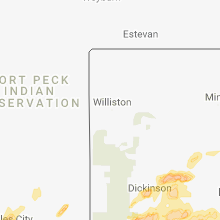
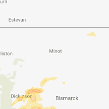
Montana
| Local Time | Report Details |
|---|---|
| 1:23 PM MDT | Quarter sized hail reported near Hamilton, MT, 45.4 miles S of Missoula, MT |
| 1:27 PM MDT | Ping Pong Ball sized hail reported near Corvallis, MT, 42.4 miles S of Missoula, MT, time estimated from radar. |
| 1:34 PM MDT | Storm damage reported in missoula county MT, 5.5 miles NW of Missoula, MT |
| 1:40 PM MDT | Quarter sized hail reported near Missoula, MT, 0.8 miles NW of Missoula, MT, two separate reports from the public of quarter sized hail around missoula. |
| 2:36 PM MDT | Quarter sized hail reported near Seeley Lake, MT, 32.3 miles NE of Missoula, MT, time estimated from radar. |
| 3:14 PM MDT | Quarter sized hail reported near Livingston, MT, 27.8 miles ENE of Bozeman, MT |
| 3:58 PM MDT | Quarter sized hail reported near Shawmut, MT, 63.3 miles NW of Billings, MT, pea size hail on highway 1 inch deep |
| 4:22 PM MDT | Golf Ball sized hail reported near Roundup, MT, 45.4 miles N of Billings, MT, 7 broken windows in home torrential rain. |
| 4:25 PM MDT | Quarter sized hail reported near Lavina, MT, 51.5 miles NW of Billings, MT |
| 4:38 PM MDT | Quarter sized hail reported near Canyon Creek, MT, 65.7 miles SW of Great Falls, MT, spotter estimated hail up to quarter size occurring at this time. |
| 5:30 PM MDT | Quarter sized hail reported near Billings, MT, 3.2 miles WSW of Billings, MT, torrential rain and broken windows. |
| 5:30 PM MDT | Grapefruit sized hail reported near Roundup, MT, 46 miles N of Billings, MT |
| 5:30 PM MDT | Quarter sized hail reported near Roundup, MT, 46.5 miles N of Billings, MT, torrential rain and broken windows. previously reported with erroneous location in yellowstone county. |
| 5:37 PM MDT | Golf Ball sized hail reported near Roundup, MT, 46.7 miles N of Billings, MT, damage to trees and truck/camper heavy damage |
| 5:42 PM MDT | Baseball sized hail reported near Roundup, MT, 46 miles N of Billings, MT |
| 5:44 PM MDT | Hen Egg sized hail reported near Roundup, MT, 46 miles N of Billings, MT, vehicles with windshields out broken window in house. |
| 5:45 PM MDT | Golf Ball sized hail reported near Roundup, MT, 46 miles N of Billings, MT, broken windows and torrential rain |
| 5:47 PM MDT | Tennis Ball sized hail reported near Roundup, MT, 46.7 miles N of Billings, MT |
| 5:48 PM MDT | Golf Ball sized hail reported near Roundup, MT, 46.7 miles N of Billings, MT |
| 6:00 PM MDT | Half Dollar sized hail reported near Roundup, MT, 46.7 miles N of Billings, MT |
| 6:00 PM MDT | Storm damage reported in musselshell county MT, 46.7 miles N of Billings, MT |
| 6:00 PM MDT | Ping Pong Ball sized hail reported near Roundup, MT, 50.9 miles N of Billings, MT |
| 6:38 PM MDT | Quarter sized hail reported near Busby, MT, 83.2 miles ESE of Billings, MT |
| 7:12 PM MDT | Quarter sized hail reported near Lavina, MT, 38.5 miles NNW of Billings, MT |
| 8:55 PM MDT | Golf Ball sized hail reported near Melstone, MT, 66.4 miles NNE of Billings, MT |
West Virginia
| Local Time | Report Details |
|---|---|
| 3:27 PM EDT | Tree down on house 1300 blk w king street in berkeley county WV, 74.3 miles W of Baltimore, MD |
| 5:18 PM EDT | Large diameter branches (6 to 8 inches) reported down in martinsburg at west king street and georgia av in berkeley county WV, 74.3 miles W of Baltimore, MD |
| 5:30 PM EDT | Tree down intersection of rocky ford rd and camp virgil tate rd. blocking both lanes of traffic. via metro911 web pag in kanawha county WV, 9.4 miles NNW of Charleston, WV |
| 5:30 PM EDT | Tree down at strawberry rd at the intersection of coal river rd has both lanes blocked. via metro911 webpag in kanawha county WV, 12.2 miles W of Charleston, WV |
| 5:45 PM EDT | Tree down with lines involved on lens creek rd at six mile hollow rd. via metro911 webpag in kanawha county WV, 8.6 miles SSE of Charleston, WV |
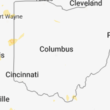
Ohio
| Local Time | Report Details |
|---|---|
| 3:40 PM EDT | 2-3 inch limbs reported broken. occurred ahead of the main stor in hamilton county OH, 6.8 miles W of Cincinnati, OH |
| 3:54 PM EDT | Reported via mping. trees uprooted or snapped... roof damag in hamilton county OH, 6.5 miles WSW of Cincinnati, OH |
| 3:56 PM EDT | One tree reported down in anderson township near salem rd. time estimated from rada in hamilton county OH, 6.7 miles ESE of Cincinnati, OH |
| 3:57 PM EDT | Storm damage reported in hamilton county OH, 4.6 miles E of Cincinnati, OH |
| 3:58 PM EDT | Shingles reported off roof of house along with tree limbs down. time estimated from rada in hamilton county OH, 7.7 miles ESE of Cincinnati, OH |
| 4:00 PM EDT | Numerous trees and branches reported down. time estimated from rada in hamilton county OH, 10.1 miles NW of Cincinnati, OH |
| 4:02 PM EDT | Tree downe in hamilton county OH, 8.4 miles E of Cincinnati, OH |
| 4:05 PM EDT | 8 inch diameter tree reported broken off at the groun in hamilton county OH, 8.8 miles NNE of Cincinnati, OH |
| 4:10 PM EDT | Tree downe in clermont county OH, 14.3 miles E of Cincinnati, OH |
| 4:12 PM EDT | Multiple trees down across pierce township and batavia township... including trees down on sr 12 in clermont county OH, 17.5 miles E of Cincinnati, OH |
| 4:17 PM EDT | Tree downe in warren county OH, 20.4 miles NNE of Cincinnati, OH |
| 4:25 PM EDT | Trees reported down. time estimated from rada in brown county OH, 36.4 miles ESE of Cincinnati, OH |
| 4:25 PM EDT | Trees reported down. time estimated from rada in brown county OH, 31.9 miles E of Cincinnati, OH |
| 4:27 PM EDT | Trees reported down. estimated time from rada in brown county OH, 43.8 miles SE of Cincinnati, OH |
| 4:31 PM EDT | One tree reported down. time estimated from rada in brown county OH, 31.4 miles E of Cincinnati, OH |
| 4:33 PM EDT | Trees reported down. time estimated from rada in brown county OH, 49.8 miles SE of Cincinnati, OH |
| 4:36 PM EDT | A couple of power poles were knocked dow in darke county OH, 63.5 miles NNW of Cincinnati, OH |
| 4:38 PM EDT | Trees downed. time estimated from rada in highland county OH, 35.8 miles E of Cincinnati, OH |
| 4:40 PM EDT | Trees downe in darke county OH, 61 miles NNW of Cincinnati, OH |
| 4:44 PM EDT | Trees reported down. time estimated from rada in adams county OH, 56.1 miles ESE of Cincinnati, OH |
| 4:47 PM EDT | Tree downe in adams county OH, 54.1 miles ESE of Cincinnati, OH |
| 4:50 PM EDT | One tree was knocked dow in darke county OH, 61 miles N of Cincinnati, OH |
| 4:51 PM EDT | Trees reported down. time estimated from rada in adams county OH, 56.4 miles ESE of Cincinnati, OH |
| 4:54 PM EDT | Trees downed. time estimated from rada in highland county OH, 39.3 miles ENE of Cincinnati, OH |
| 5:12 PM EDT | Tree reported down across sr 73. time estimated from rada in scioto county OH, 68.2 miles E of Cincinnati, OH |
| 5:17 PM EDT | Tree down at the intersection of sr 125 and us 5 in scioto county OH, 81.2 miles ESE of Cincinnati, OH |
| 5:19 PM EDT | Tree down on the 4600 block of mcdermott pond creek road in scioto county OH, 78.2 miles S of Columbus, OH |
| 10:23 PM EDT | Tree downed. fell on hous in williams county OH, 39.5 miles NE of Fort Wayne, IN |
North Dakota
| Local Time | Report Details |
|---|---|
| 2:00 PM MDT | Strong winds and hail....largest hail stones nickel in dunn county ND, 79.8 miles WNW of Bismarck, ND |
| 2:00 PM MDT | Half Dollar sized hail reported near Halliday, ND, 76.9 miles WNW of Bismarck, ND, busted window due to hail. report of 1.75 inches of rain. |
| 3:15 PM MDT | Quarter sized hail reported near Dickinson, ND, 93.3 miles SSE of Williston, ND, still hailing at time of report. |
| 4:20 PM MDT | Quarter sized hail reported near New England, ND, 101.1 miles W of Bismarck, ND, a lot of quarter sized hail lasted 20 minutes. |
| 6:15 PM CDT | Storm damage reported in morton county ND, 49.9 miles W of Bismarck, ND |
| 7:29 PM MDT | Quarter sized hail reported near Mott, ND, 79.7 miles WSW of Bismarck, ND, quarter size hail still coming down at the time of the report. |
| 7:31 PM MDT | Half Dollar sized hail reported near Mott, ND, 79.5 miles WSW of Bismarck, ND, hail slightly bigger than quarter size coming down in mott at the time of this report. |
| 8:09 PM MDT | Quarter sized hail reported near New Leipzig, ND, 63.4 miles WSW of Bismarck, ND, hail up to the size of quarters still coming down in new leipzig at the time of this report. |
| 11:20 PM CDT | Quarter sized hail reported near Selfridge, ND, 52.6 miles S of Bismarck, ND, nickel to quarter size hail along with torrential rainfall occurred along highway 6 near selfridge. spotter reported they could not see more than 50 to 75 feet in front |
Georgia
| Local Time | Report Details |
|---|---|
| 4:08 PM EDT | Quarter sized hail reported near Tunnel Hill, GA, 21 miles SE of Chattanooga, TN, quarter-sized hail reported on mount vernon rd near tunnel hill. |
South Carolina
| Local Time | Report Details |
|---|---|
| 4:15 PM EDT | Schp reported a tree down at old pendleton rd and eighteen mile rd in pickens county SC, 12.3 miles SW of Greenville, SC |
| 4:20 PM EDT | Schp reported a tree down at bishop branch rd and liberty highway in anderson county SC, 12.2 miles SSW of Greenville, SC |
| 4:39 PM EDT | Schp reported a tree down at mush creek rd and boswell ci in greenville county SC, 17.5 miles NE of Greenville, SC |
| 4:50 PM EDT | Schp reported a tree down on hawkins rd at bridwell wa in greenville county SC, 14.5 miles NE of Greenville, SC |
| 4:50 PM EDT | Public reported a tree down on sandy flat rd n of taylor in greenville county SC, 18 miles NE of Greenville, SC |
| 4:50 PM EDT | Schp reported a tree down at highway 14 and morrow rd in greenville county SC, 27.6 miles NE of Greenville, SC |
| 5:07 PM EDT | 911 call center reported a tree down on south union r in oconee county SC, 32.6 miles SW of Greenville, SC |
| 5:20 PM EDT | Nws employee reported a tree down on batesville rd in the kingsgate subdivisio in greenville county SC, 21.1 miles E of Greenville, SC |
| 5:30 PM EDT | 911 call center reported a few trees down around spartanbur in spartanburg county SC, 39 miles ENE of Greenville, SC |
| 5:30 PM EDT | 911 call center reported a tree down on blackjack r in oconee county SC, 31.5 miles WSW of Greenville, SC |
| 6:08 PM EDT | 911 call center reported a tree down at shelor ferry rd and north port bass rd in fair pla in oconee county SC, 34.3 miles SW of Greenville, SC |
| 6:15 PM EDT | Schp reported a tree down at highway 413 and abbeville highway in anderson county SC, 32.5 miles S of Greenville, SC |
North Carolina
| Local Time | Report Details |
|---|---|
| 4:20 PM EDT | Several trees down across the count in clay county NC, 63 miles S of Knoxville, TN |
| 4:35 PM EDT | 911 call center reported a tree down on 226 n near woodlaw in mcdowell county NC, 56.2 miles S of Bristol, TN |
| 4:58 PM EDT | 911 call center reported a tree down on cove creek d in rutherford county NC, 49.8 miles NNE of Greenville, SC |
| 5:16 PM EDT | 911 call center reported tree and power lines down on chimney rock r in rutherford county NC, 52.5 miles NE of Greenville, SC |
| 5:25 PM EDT | 911 call center reported a tree down on nc 108 in rutherford county NC, 50.7 miles NE of Greenville, SC |
| 5:50 PM EDT | Quarter sized hail reported near Lawndale, NC, 44.6 miles WNW of Charlotte, NC, trained spotter reported quarter (1.00 in) size hail on west stagecoach trail. |
| 8:27 PM EDT | 911 call center reported numerous trees down along the french broad rive in madison county NC, 60.6 miles SSW of Bristol, TN |
| 8:55 PM EDT | Numerous trees down and power outages around enk in buncombe county NC, 49.7 miles N of Greenville, SC |
| 8:55 PM EDT | Amateur radio reported numerous trees down and power outages in the candler are in buncombe county NC, 49.1 miles N of Greenville, SC |
| 9:40 PM EDT | 911 call center reported trees down on rock springs church r in rutherford county NC, 48 miles NNE of Greenville, SC |
| 9:45 PM EDT | 911 call center reported a tree branch fell on a powerline and knocked it down on whiteside r in rutherford county NC, 53.2 miles NE of Greenville, SC |
Virginia
| Local Time | Report Details |
|---|---|
| 4:49 PM EDT | Tree down at the intersection of telegraph springs road and snickersville turnpik in loudoun county VA, 62.6 miles WSW of Baltimore, MD |
| 4:49 PM EDT | Tree down at the intersection of bald hill road and loyalty roa in loudoun county VA, 52.2 miles W of Baltimore, MD |
Wyoming
| Local Time | Report Details |
|---|---|
| 6:00 PM MDT | Quarter sized hail reported near Upton, WY, 34.7 miles ESE of Gillette, WY |
| 6:28 PM MDT | Quarter sized hail reported near Moorcroft, WY, 37.9 miles E of Gillette, WY |
| 7:08 PM MDT | Quarter sized hail reported near Alva, WY, 59.2 miles ENE of Gillette, WY |
| 7:48 PM MDT | Quarter sized hail reported near Hulett, WY, 54.2 miles NE of Gillette, WY |
Arkansas
| Local Time | Report Details |
|---|---|
| 9:59 PM CDT | Ping Pong Ball sized hail reported near Cherokee Village, AR, 92.2 miles S of Salem, MO, law enforcement reporting ping pong ball size hail in cherokee village. |
| 9:59 PM CDT | Ping Pong Ball sized hail reported near Hardy, AR, 92.2 miles S of Salem, MO, law enforcement reporting ping pong ball size hail in cherokee village. |
| 10:07 PM CDT | Quarter sized hail reported near Hardy, AR, 92.2 miles S of Salem, MO, trained spotter reports quarter size hail in the town of cherokee village. |
| 10:07 PM CDT | Quarter sized hail reported near Cherokee Village, AR, 92.2 miles S of Salem, MO, trained spotter reports quarter size hail in the town of cherokee village. |
| 10:36 PM CDT | Quarter sized hail reported near Ravenden, AR, 97.6 miles S of Salem, MO |
| 11:15 PM CDT | Trees were down in jaspe in newton county AR, 81.6 miles ENE of Fort Smith, AR |
| 11:33 PM CDT | Law enforcement reports a large tree down at the intersection of south 5th street and main street in marmaduke... greene count in greene county AR, 74.2 miles NNW of Memphis, TN |
| 12:26 AM CDT | Aluminum flag pole snapped half way up by severe winds in paragould in greene count in greene county AR, 67.9 miles NNW of Memphis, TN |
| 12:30 AM CDT | Numerous trees and power lines down across paragould to include south 7th street... carroll road... and west thompson street. these roads are currently closed due to tr in greene county AR, 67.9 miles NNW of Memphis, TN |
Connect with Interactive Hail Maps