

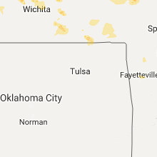
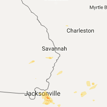
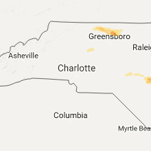
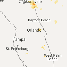
Hail Map for Wednesday, May 31, 2017

Number of Impacted Households on 5/31/2017
0
Impacted by 1" or Larger Hail
0
Impacted by 1.75" or Larger Hail
0
Impacted by 2.5" or Larger Hail
Square Miles of Populated Area Impacted on 5/31/2017
0
Impacted by 1" or Larger Hail
0
Impacted by 1.75" or Larger Hail
0
Impacted by 2.5" or Larger Hail


Cities Most Affected by Hail Storms of 5/31/2017
| Hail Size | Demographics of Zip Codes Affected | ||||||
|---|---|---|---|---|---|---|---|
| City | Count | Average | Largest | Pop Density | House Value | Income | Age |
| Paola, KS | 3 | 2.08 | 2.50 | 53 | $110k | $46.6k | 41.7 |
| Jacksonville Beach, FL | 2 | 2.38 | 2.75 | 3396 | $130k | $48.2k | 40.2 |
| Goodland, KS | 2 | 1.88 | 2.00 | 9 | $65k | $33.1k | 41.5 |
| Edson, KS | 1 | 2.00 | 2.00 | 1 | $84k | $30.4k | 48.7 |
| Poughkeepsie, NY | 1 | 1.75 | 1.75 | 1275 | $147k | $60.4k | 39.6 |
| Newton, KS | 1 | 1.75 | 1.75 | 91 | $72k | $40.0k | 37.9 |
| Schenectady, NY | 1 | 1.75 | 1.75 | 1780 | $133k | $65.4k | 44.1 |
| Neptune Beach, FL | 1 | 1.75 | 1.75 | 3170 | $148k | $53.7k | 40.8 |
| Ponte Vedra Beach, FL | 1 | 1.75 | 1.75 | 910 | $270k | $74.0k | 48.5 |
| Carbondale, KS | 1 | 1.75 | 1.75 | 39 | $69k | $37.3k | 42.8 |
| Silver Lake, NH | 1 | 1.75 | 1.75 | 40 | $106k | $40.8k | 50.1 |
Hail and Wind Damage Spotted on 5/31/2017
Filter by Report Type:Hail ReportsWind Reports
States Impacted
West Virginia, Kansas, North Carolina, Georgia, Vermont, Ohio, Missouri, Kentucky, New York, Florida, Pennsylvania, Texas, Virginia, New Hampshire, Massachusetts, Maryland, Colorado, Connecticut, New Jersey, MontanaWest Virginia
| Local Time | Report Details |
|---|---|
| 12:04 PM EDT | Several trees blocking rte 60 between shrewsbury and glasgow. time estimated via radar in kanawha county WV, 13.6 miles SE of Charleston, WV |
| 12:09 PM EDT | Multiple large limbs down in downtown montgomery in fayette county WV, 21.3 miles SE of Charleston, WV |
| 12:19 PM EDT | Tree down blocking rt 60 in fayette county WV, 27.3 miles SE of Charleston, WV |
| 12:44 PM EDT | Multiple small trees down in clifftop/babcock area. time estimated via rada in fayette county WV, 45.1 miles ESE of Charleston, WV |
| 12:46 PM EDT | Three large trees down in downtown winona. time estimated via rada in fayette county WV, 40.9 miles ESE of Charleston, WV |
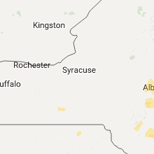
Kansas
| Local Time | Report Details |
|---|---|
| 12:00 PM CDT | Quarter sized hail reported near Auburn, KS, 42.9 miles ESE of Manhattan, KS |
| 12:01 PM CDT | Ping Pong Ball sized hail reported near Carbondale, KS, 45.9 miles ESE of Manhattan, KS |
| 12:16 PM CDT | Golf Ball sized hail reported near Carbondale, KS, 51.6 miles ESE of Manhattan, KS, hail lasted for three minutes. the duration of the hail event was 3 minutes. |
| 12:25 PM CDT | Half Dollar sized hail reported near Carbondale, KS, 53.1 miles ESE of Manhattan, KS |
| 12:32 PM CDT | Quarter sized hail reported near Overbrook, KS, 57.1 miles WSW of Kansas City, MO |
| 12:52 PM CDT | Storm damage reported in neosho county KS, 8.4 miles SSW of Chanute, KS |
| 12:53 PM CDT | Ping Pong Ball sized hail reported near Ottawa, KS, 51.8 miles SW of Kansas City, MO |
| 12:58 PM CDT | 50 to 60 mph wind gust when leading edge of storm moved i in neosho county KS, 13.3 miles S of Chanute, KS |
| 1:00 PM CDT | Quarter sized hail reported near Ottawa, KS, 51.5 miles SW of Kansas City, MO, west edge of ottawa. |
| 1:06 PM CDT | Quarter sized hail reported near Ottawa, KS, 51.2 miles SW of Kansas City, MO |
| 1:08 PM CDT | Half Dollar sized hail reported near Ottawa, KS, 50.3 miles SW of Kansas City, MO |
| 1:19 PM CDT | Ping Pong Ball sized hail reported near Spring Hill, KS, 32.9 miles SW of Kansas City, MO |
| 1:20 PM CDT | Golf Ball sized hail reported near Paola, KS, 35 miles SSW of Kansas City, MO, golfball-sized hail at hillsdale lake |
| 1:24 PM CDT | Hen Egg sized hail reported near Paola, KS, 36.1 miles SSW of Kansas City, MO |
| 1:35 PM CDT | Tennis Ball sized hail reported near Paola, KS, 37 miles SSW of Kansas City, MO |
| 1:39 PM CDT | 6 inch tree limb down at the intersection of hwy 68 and osawatomie road in miami county KS, 38.5 miles SSW of Kansas City, MO |
| 1:50 PM CDT | Quarter sized hail reported near Waverly, KS, 42.9 miles NNW of Chanute, KS, sharp 3e. |
| 1:53 PM CDT | Tree limbs down in mccun in crawford county KS, 33 miles SE of Chanute, KS |
| 1:58 PM CDT | Limbs down in linn county KS, 52.8 miles S of Kansas City, MO |
| 2:00 PM CDT | Golf Ball sized hail reported near Newton, KS, 24.3 miles N of Wichita, KS |
| 2:18 PM CDT | Half Dollar sized hail reported near Newton, KS, 26.7 miles N of Wichita, KS |
| 6:23 PM CDT | Quarter sized hail reported near Saint Francis, KS, 46.9 miles WNW of Colby, KS, hail had been falling for about 20-30 min... started off around nickel to penny. quarter sized hail occurred around 523mdt and still falling. hail is covering ground. |
| 7:19 PM MDT | Also getting dime to nickel size hai in sherman county KS, 35.8 miles W of Colby, KS |
| 7:22 PM MDT | Storm damage reported in sherman county KS, 40.6 miles W of Colby, KS |
| 7:24 PM MDT | Quarter sized hail reported near Goodland, KS, 35.8 miles W of Colby, KS |
| 7:32 PM MDT | Hen Egg sized hail reported near Goodland, KS, 35.6 miles W of Colby, KS |
| 7:42 PM MDT | Golf Ball sized hail reported near Goodland, KS, 34.3 miles W of Colby, KS |
| 7:45 PM MDT | Storm damage reported in sherman county KS, 35.8 miles W of Colby, KS |
| 7:45 PM MDT | Hen Egg sized hail reported near Edson, KS, 28.1 miles SW of Colby, KS, report stated just a little over 2 inch hail. |
| 9:10 PM CDT | Half Dollar sized hail reported near Wallace, KS, 32.6 miles SW of Colby, KS, hailed for 30 minutes. 0.88 inches of rain also fell. |
| 8:15 PM MDT | Location grand street near the hospital in goodland... ks. 30ft trailer rolled west three times. it rolled over a shed and privacy fence. a large cottonwood tree was al in sherman county KS, 35.8 miles W of Colby, KS |
| 10:50 PM CDT | Quarter sized hail reported near Jamestown, KS, 73.7 miles WNW of Manhattan, KS, mostly nickel size stones but a few quarter size stones. |
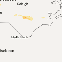
North Carolina
| Local Time | Report Details |
|---|---|
| 1:50 PM EDT | Quarter sized hail reported near Spring Lake, NC, 39 miles SSW of Raleigh, NC, spotter roported quarter size hail. |
| 3:36 PM EDT | One tree down near the 6000 block of maxwell r in sampson county NC, 47.9 miles S of Raleigh, NC |
| 3:36 PM EDT | Power line down near the 800 block of hayes mill r in sampson county NC, 46 miles S of Raleigh, NC |
| 3:37 PM EDT | One tree down near the 3300 block of baptist chapel r in sampson county NC, 44.6 miles S of Raleigh, NC |
| 3:38 PM EDT | One tree down near the 2300 block of autry mill r in sampson county NC, 45.2 miles S of Raleigh, NC |
| 3:39 PM EDT | One tree down near the 1000 block of tew r in sampson county NC, 45.4 miles S of Raleigh, NC |
| 3:40 PM EDT | Multiple trees dow in sampson county NC, 47.3 miles S of Raleigh, NC |
| 3:40 PM EDT | One tree down near the 2200 block of autry mill r in sampson county NC, 45.2 miles S of Raleigh, NC |
| 3:42 PM EDT | Multiple trees dow in sampson county NC, 46.2 miles S of Raleigh, NC |
| 3:45 PM EDT | One tree down near the 6200 block of n. salemburg r in sampson county NC, 48.1 miles S of Raleigh, NC |
| 3:47 PM EDT | One tree down near the 4500 block of n. salemburg hw in sampson county NC, 49.5 miles S of Raleigh, NC |
| 3:48 PM EDT | One tree and a power line down near the 6000 block of high house r in sampson county NC, 48.8 miles S of Raleigh, NC |
| 3:48 PM EDT | One tree and a power line down near the 6000 block of high house r in sampson county NC, 48.8 miles S of Raleigh, NC |
| 3:48 PM EDT | Power line down near the intersection of parker memorial rd and high house r in sampson county NC, 48.9 miles SSE of Raleigh, NC |
| 3:50 PM EDT | Multiple trees dow in sampson county NC, 45.7 miles SSE of Raleigh, NC |
| 4:02 PM EDT | One tree down near the intersection of keener rd and hobbton hw in sampson county NC, 50 miles SSE of Raleigh, NC |
| 4:24 PM EDT | Power line down near the intersection of wilmington rd and needmore rd in turke in sampson county NC, 53.7 miles NNW of Wilmington, NC |
| 4:24 PM EDT | Large tree on house and carport blown down on two cars at reinhardt circle on hwy 7 in lincoln county NC, 23.8 miles NW of Charlotte, NC |
| 4:26 PM EDT | Tree down on power lines near the 8400 block of turkey hw in sampson county NC, 53.6 miles NNW of Wilmington, NC |
| 4:35 PM EDT | County official reports mulitiple trees down on hwy 7 in lincoln county NC, 18.8 miles NNW of Charlotte, NC |
| 4:52 PM EDT | Trees dow in duplin county NC, 50 miles N of Wilmington, NC |
| 4:56 PM EDT | Trees dow in duplin county NC, 53.4 miles N of Wilmington, NC |
| 4:56 PM EDT | Four trees down on old us hwy 64 in the reeds crossroads communit in davidson county NC, 51.2 miles NNE of Charlotte, NC |
| 5:03 PM EDT | Tree down on madam moores lane in new ber in craven county NC, 78.4 miles NE of Wilmington, NC |
| 5:28 PM EDT | Trained spotter reports winds between 60 and 70 mph at wt harris blvd and robinson church roa in mecklenburg county NC, 6.1 miles E of Charlotte, NC |
| 5:28 PM EDT | Trained spotter reports winds between 60 and 70 mph at wt harris blvd and robinson church roa in mecklenburg county NC, 6.1 miles E of Charlotte, NC |
| 5:58 PM EDT | Trained spotter measured winds gusting to 59 mph at stevens mill road and lawyers roa in union county NC, 13.6 miles ESE of Charlotte, NC |
| 6:22 PM EDT | Thunderstorm winds downed several trees near the intersection of moore springs road and hanging rock park roa in stokes county NC, 61.8 miles SSW of Roanoke, VA |
| 6:35 PM EDT | Outflow winds from a strong thunderstorm downed a tree near the intersection of north carolina highway 8 and highway 8 in stokes county NC, 63.6 miles SSW of Roanoke, VA |
| 6:50 PM EDT | Thunderstorm winds downed a single tree in a homeowners back yard along k fork raod near the border of rockingham and stokes count in rockingham county NC, 61.6 miles S of Roanoke, VA |
| 6:50 PM EDT | Thunderstorm winds resulted in at least two trees down near the intersection of west hunter street and south wilson stree in rockingham county NC, 60.8 miles S of Roanoke, VA |
| 6:50 PM EDT | Thunderstorm winds downed numerous trees near the intersection of us 220 and ellisboro roa in rockingham county NC, 62.2 miles S of Roanoke, VA |
| 6:55 PM EDT | Thunderstorm winds resulted in several uprooted and snapped trees near the community of madiso in rockingham county NC, 60.8 miles S of Roanoke, VA |
| 7:06 PM EDT | Thunderstorm winds downed numerous trees along buckhorn trail... including a few trees that were snapped over 30 feet in the air. a nearbye creek also escaped its banks in rockingham county NC, 64.8 miles S of Roanoke, VA |
| 7:18 PM EDT | Thunderstorm winds downed two large trees along link roa in rockingham county NC, 66.1 miles S of Roanoke, VA |
| 7:18 PM EDT | Thunderstorm winds downed several trees and powerlines along cook florist roa in rockingham county NC, 66.2 miles WNW of Raleigh, NC |
| 7:18 PM EDT | Fema official relays report of numerous 12 inch or greater diameter trees down across rail road tracks impeeding travel near the turner drive crossin in rockingham county NC, 66.1 miles SSE of Roanoke, VA |
| 7:22 PM EDT | Thunderstorm winds resulted in a tree down near the intersection of iron works road and monroeton roa in rockingham county NC, 67.2 miles S of Roanoke, VA |
| 7:22 PM EDT | Thunderstorm winds downed a swath of trees totaling an unknown number near the interchange of us 158 and iron works roa in rockingham county NC, 66.2 miles S of Roanoke, VA |
| 7:25 PM EDT | Quarter sized hail reported near Reidsville, NC, 66.5 miles SSE of Roanoke, VA, hail enough to accumulate on grassy surfaces. large limbs reported down within the community near briarwood street. |
| 7:35 PM EDT | 2 trees down near the intersection of brann rd and portage r in guilford county NC, 61.6 miles WNW of Raleigh, NC |
| 7:38 PM EDT | Quarter sized hail reported near Reidsville, NC, 66.5 miles SSE of Roanoke, VA, hail enough to accumulate on grassy surfaces. large limbs reported down within the community near briarwood street. |
| 7:40 PM EDT | Thunderstorm winds resulted in large tree limbs blown down just south of camp springs. pea to dime size hail along with heavy rain approaching 2 inches in a 15 minutes in caswell county NC, 59.3 miles NW of Raleigh, NC |
| 7:43 PM EDT | Thunderstorm winds downed a tree near the intersection of boone road and underwood roa in caswell county NC, 57.2 miles NW of Raleigh, NC |
| 7:49 PM EDT | Thunderstorm winds downed a few trees along stoney creek mountain roa in caswell county NC, 53.6 miles NW of Raleigh, NC |
| 7:49 PM EDT | Thunderstorm winds downed a few trees along stoney creek mountain roa in caswell county NC, 54.5 miles NW of Raleigh, NC |
Georgia
| Local Time | Report Details |
|---|---|
| 2:45 PM EDT | Quarter sized hail reported near Richmond Hill, GA, 18 miles SW of Savannah, GA, social media user relayed photographs of up to 1-inch hail near the intersection of port royal road and harris trail in richmond hill. time estimated by radar. |
| 3:12 PM EDT | Social media relayed report of roof shingle damage and small tree limbs knocked dow in bryan county GA, 17.4 miles SW of Savannah, GA |
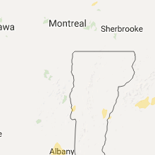
Vermont
| Local Time | Report Details |
|---|---|
| 2:50 PM EDT | Quarter sized hail reported near Colchester, VT, 4.4 miles N of Burlington, VT, reported at colchester pd |
| 2:50 PM EDT | Treed down next to house on e rd. time estimated in chittenden county VT, 5.4 miles NE of Burlington, VT |
| 3:29 PM EDT | Trees down on wires in richmond in addison county VT, 21.2 miles S of Burlington, VT |
| 3:29 PM EDT | Trees down on wires in richmond in chittenden county VT, 11.9 miles ESE of Burlington, VT |
| 3:30 PM EDT | Tree down along i-89 per vt state police. time estimated in washington county VT, 26 miles ESE of Burlington, VT |
| 3:30 PM EDT | Powerline down and blown transformer. report from vt state police. time estimate in washington county VT, 26.2 miles ESE of Burlington, VT |
| 3:40 PM EDT | Trees down along route 108 near town farm lane in lamoille county VT, 25.4 miles E of Burlington, VT |
| 3:52 PM EDT | Quarter sized hail reported near Hardwick, VT, 41.7 miles E of Burlington, VT |
| 3:54 PM EDT | Quarter sized hail reported near Orwell, VT, 49.1 miles S of Burlington, VT |
| 3:57 PM EDT | Quarter sized hail reported near East Hardwick, VT, 46.2 miles E of Burlington, VT |
| 4:23 PM EDT | Trees down on hubbarton road in rutland county VT, 57.8 miles S of Burlington, VT |
| 4:24 PM EDT | Trees down on severance hill road in caledonia county VT, 62.5 miles E of Burlington, VT |
| 4:34 PM EDT | Quarter sized hail reported near East Hardwick, VT, 46.2 miles E of Burlington, VT |
| 4:43 PM EDT | Trees down on route 18 in caledonia county VT, 64.3 miles E of Burlington, VT |
| 4:50 PM EDT | Trees down on roadway in essex county VT, 65.5 miles E of Burlington, VT |
Ohio
| Local Time | Report Details |
|---|---|
| 3:15 PM EDT | Several trees down across town in columbiana county OH, 32.9 miles WNW of Pittsburgh, PA |
Missouri
| Local Time | Report Details |
|---|---|
| 2:20 PM CDT | Storm damage reported in bates county MO, 51.9 miles S of Kansas City, MO |
| 2:47 PM CDT | Delayed report...photo via facebook of large tree blown over and snapped at base in bates county MO, 59.7 miles SSE of Kansas City, MO |
| 2:47 PM CDT | Storm damage reported in bates county MO, 66.3 miles ENE of Chanute, KS |
| 3:10 PM CDT | Quarter sized hail reported near Harwood, MO, 70.9 miles NW of Springfield, MO, quarter size hail covering farm pasture as well as winds estimated at 60 mph. |
Kentucky
| Local Time | Report Details |
|---|---|
| 3:25 PM EDT | Quarter sized hail reported near Salyersville, KY, 50.2 miles E of Irvine, KY |
| 4:10 PM EDT | Tree reported down in the city limits of prestonsburg...time estimated based on rada in floyd county KY, 66.1 miles E of Irvine, KY |
New York
| Local Time | Report Details |
|---|---|
| 3:39 PM EDT | Quarter sized hail reported near Hague, NY, 52.1 miles SSW of Burlington, VT |
| 3:50 PM EDT | Tree down on road in montgomery county NY, 21.5 miles WNW of Schenectady, NY |
| 4:15 PM EDT | Quarter sized hail reported near Schenectady, NY, 2.3 miles SSW of Schenectady, NY |
| 4:15 PM EDT | Trees and wires down in albany county NY, 7.3 miles SE of Schenectady, NY |
| 4:18 PM EDT | Quarter sized hail reported near Schenectady, NY, 2.1 miles SW of Schenectady, NY |
| 4:18 PM EDT | Tree down on east lydius street in albany county NY, 4.3 miles S of Schenectady, NY |
| 4:20 PM EDT | Tree into house on east country club drive in niskayuna. no injuries reporte in schenectady county NY, 2.7 miles ESE of Schenectady, NY |
| 4:20 PM EDT | Tree and wires down and a transformer on fire on cordell road in albany county NY, 4.2 miles SSE of Schenectady, NY |
| 4:20 PM EDT | Trees and wires down in albany county NY, 7.3 miles SE of Schenectady, NY |
| 4:21 PM EDT | Trees and wires down along kings road in albany county NY, 5.6 miles SSE of Schenectady, NY |
| 4:21 PM EDT | Trees and wires down along kings road in albany county NY, 5.6 miles SSE of Schenectady, NY |
| 4:21 PM EDT | Golf Ball sized hail reported near Schenectady, NY, 2.4 miles ENE of Schenectady, NY |
| 4:22 PM EDT | Tree down on albany street in albany county NY, 7 miles SE of Schenectady, NY |
| 4:22 PM EDT | Trees and wires down at the intersection of kings road and morris road in albany county NY, 4.8 miles SSE of Schenectady, NY |
| 4:22 PM EDT | Tree down at the intersection of east old state road and kings road in albany county NY, 7.1 miles SSE of Schenectady, NY |
| 4:22 PM EDT | Trees and wires down on morris road in albany county NY, 5.3 miles SE of Schenectady, NY |
| 4:24 PM EDT | Tree down at the intersection of new scotland road at stove pipe road in albany county NY, 14 miles S of Schenectady, NY |
| 4:26 PM EDT | Trees and wires down in saratoga county NY, 12.3 miles NNE of Schenectady, NY |
| 4:30 PM EDT | Trees and wires down on road in schenectady county NY, 3.4 miles SE of Schenectady, NY |
| 4:30 PM EDT | Tree down on roa in albany county NY, 8 miles ESE of Schenectady, NY |
| 4:34 PM EDT | Tree down on princess lane in albany county NY, 12.4 miles SE of Schenectady, NY |
| 4:35 PM EDT | Tree down on osborne road in albany county NY, 11.2 miles SE of Schenectady, NY |
| 4:36 PM EDT | Tree down on cherry tree road in albany county NY, 12 miles SE of Schenectady, NY |
| 4:36 PM EDT | Report of a tree down in oneida county NY, 42 miles E of Syracuse, NY |
| 4:36 PM EDT | Quarter sized hail reported near Schenectady, NY, 1 miles SSE of Schenectady, NY |
| 4:40 PM EDT | Tree down at the intersection of 14th street and 2nd ave in albany county NY, 13.8 miles ESE of Schenectady, NY |
| 4:40 PM EDT | Quarter sized hail reported near Freehold, NY, 31.3 miles S of Schenectady, NY |
| 4:50 PM EDT | Trees and wires down in rensselaer county NY, 23.3 miles ESE of Schenectady, NY |
| 4:53 PM EDT | Quarter sized hail reported near Cayuta, NY, 58.3 miles SSW of Syracuse, NY, estimated quater sized hail |
| 6:15 PM EDT | Trees down in dutchess county NY, 62.7 miles N of Brooklyn, NY |
| 6:50 PM EDT | Golf Ball sized hail reported near Poughkeepsie, NY, 68.3 miles N of Brooklyn, NY, golfball size hail reported on mitchell ave |
| 6:56 PM EDT | Quarter sized hail reported near Poughkeepsie, NY, 69.7 miles N of Brooklyn, NY |
| 7:15 PM EDT | Trees down in dutchess county NY, 62.7 miles N of Brooklyn, NY |
| 7:27 PM EDT | Trees down in dutchess county NY, 60 miles N of Brooklyn, NY |
| 7:30 PM EDT | Multiple maple trees downed in dutchess county NY, 65.5 miles NNE of Brooklyn, NY |
| 7:30 PM EDT | Time estimated. tree tops snapped off. house impaled by branches. shed blown down and partial collapse of house. event occured on maloney rd. near rt. 376 in dutchess county NY, 62.7 miles N of Brooklyn, NY |
| 8:00 PM EDT | Time estimated. tree tops snapped off. house impaled by branches. shed blown down and partial collapse of house. event occured on maloney rd. near rt. 376 in dutchess county NY, 62.7 miles N of Brooklyn, NY |
Florida
| Local Time | Report Details |
|---|---|
| 3:50 PM EDT | Quarter sized hail reported near Jacksonville, FL, 15.1 miles ENE of Jacksonville, FL, trained spotter estimates quarter sized hail at mayport. hail was covering the ground. |
| 3:55 PM EDT | Quarter sized hail reported near Callahan, FL, 16.5 miles NW of Jacksonville, FL, wjxt tv relayed a social media photo of hail near quarter size in the vicinity of ratliff and callahan. time of event based on radar data. |
| 3:55 PM EDT | Quarter sized hail reported near Jacksonville, FL, 15.3 miles N of Jacksonville, FL, public report of quarter sized hail and winds estimated at 35-40 mph. report location about 5 miles north of jacksonville international airport. |
| 4:10 PM EDT | The automated surface observing station at jacksonville international airport reported a peak northwesterly wind gust of 66 mph. dime sized hail observed at nws jackson in duval county FL, 10.7 miles NNW of Jacksonville, FL |
| 4:25 PM EDT | Off duty nws employeee in oceanway reports 60 to 65 mph wind gust in duval county FL, 11.8 miles N of Jacksonville, FL |
| 4:30 PM EDT | Public report of a downed tree to the southeast of yulee. time of damage based on radar dat in nassau county FL, 20.1 miles NNE of Jacksonville, FL |
| 4:50 PM EDT | Quarter sized hail reported near Jacksonville, FL, 15.1 miles ENE of Jacksonville, FL, trained spotter estimates quarter sized hail at mayport. hail was covering the ground. |
| 4:55 PM EDT | Public report of a roof peeled off a local business near the fort george ferry landing along hecksher drive. insulation from the roof was thrown westward across the roa in duval county FL, 13.7 miles ENE of Jacksonville, FL |
| 5:02 PM EDT | Half Dollar sized hail reported near Atlantic Beach, FL, 14.1 miles E of Jacksonville, FL, first coast news relayed a social media photo of half dollar sized hail from dutton island park just east of the intracoastal waterway in atlantic beach. |
| 5:10 PM EDT | Quarter sized hail reported near Neptune Beach, FL, 15.4 miles E of Jacksonville, FL, public report via social media of quarter sized hail near fletcher high school in atlantic beach. |
| 5:10 PM EDT | Golf Ball sized hail reported near Neptune Beach, FL, 16 miles E of Jacksonville, FL, wjax tv relayed a social media photo of golf ball sized hail in neptune beach. |
| 5:15 PM EDT | Half Dollar sized hail reported near Neptune Beach, FL, 16 miles E of Jacksonville, FL, duval county emergency manager reports half dollar sized hail in neptune beach. |
| 5:22 PM EDT | Quarter sized hail reported near Jacksonville Beach, FL, 14.8 miles E of Jacksonville, FL, wjax tv relayed a public report of quarter sized hail along penman road. |
| 5:25 PM EDT | Quarter sized hail reported near Jacksonville Beach, FL, 16.3 miles ESE of Jacksonville, FL, trained spotter reports quarter sized hail along third street in jacksonville beach. |
| 5:30 PM EDT | Baseball sized hail reported near Jacksonville Beach, FL, 16.3 miles ESE of Jacksonville, FL, wjax tv relayed a social media photo of baseball sized hail from jacksonville beach. |
| 5:50 PM EDT | Hen Egg sized hail reported near Jacksonville Beach, FL, 16.3 miles ESE of Jacksonville, FL, first coast news relayed a social media photo of hailstones near 2 inches in diameter taken at gingers place restaurant in jacksonville beach. time of event based on ra |
| 6:20 PM EDT | Wjax tv relayed a social media photo of trees snapped along 20 mile road in nocatee. time of damage based on radar dat in st. johns county FL, 20.2 miles SE of Jacksonville, FL |
| 6:20 PM EDT | Golf Ball sized hail reported near Ponte Vedra Beach, FL, 17.1 miles ESE of Jacksonville, FL, wjax tv relayed a report of hail up to golf ball size along solana road in ponte vedra beach. |
| 6:25 PM EDT | Quarter sized hail reported near Ponte Vedra, FL, 19.9 miles SE of Jacksonville, FL, off duty national weather service employee reports quarter sized hail in nocatee. |
Pennsylvania
| Local Time | Report Details |
|---|---|
| 3:55 PM EDT | Tree down along nicholson r in allegheny county PA, 10.8 miles NNW of Pittsburgh, PA |
| 4:09 PM EDT | Tree down on kittanning st in allegheny county PA, 5.8 miles NNE of Pittsburgh, PA |
| 4:09 PM EDT | Power pole and trees down around hampton township in allegheny county PA, 11.6 miles NNE of Pittsburgh, PA |
| 4:12 PM EDT | Tree down on pj mcardle roadway in allegheny county PA, 0.9 miles SW of Pittsburgh, PA |
| 4:19 PM EDT | Tree limb down on vehicle in allegheny county PA, 12.2 miles ENE of Pittsburgh, PA |
| 4:19 PM EDT | Tree down on wires along roosevelt s in allegheny county PA, 6.1 miles ENE of Pittsburgh, PA |
| 4:31 PM EDT | Wires down along gun club road in westmoreland county PA, 15.7 miles E of Pittsburgh, PA |
| 4:32 PM EDT | Tree down on pennsylvania turnpike in westmoreland county PA, 15.9 miles E of Pittsburgh, PA |
| 4:33 PM EDT | Tree down on bulltown rd in westmoreland county PA, 17.3 miles E of Pittsburgh, PA |
| 4:43 PM EDT | Tree down on pennsylvania ave in westmoreland county PA, 19.1 miles ESE of Pittsburgh, PA |
| 4:44 PM EDT | Tree down in westmoreland county PA, 21.8 miles ESE of Pittsburgh, PA |
| 4:53 PM EDT | Tree down on rayann dr in westmoreland county PA, 30 miles E of Pittsburgh, PA |
| 5:18 PM EDT | Power pole and trees down around hampton township in allegheny county PA, 11.6 miles NNE of Pittsburgh, PA |
| 7:25 PM EDT | Tree down at irish hill road. tree over road. 911 dispatch fee in susquehanna county PA, 40.5 miles NNW of Scranton, PA |
| 7:30 PM EDT | Large tree down blocking whole road in auburn twp. heard on 911 dispatc in susquehanna county PA, 26.7 miles NW of Scranton, PA |
| 7:30 PM EDT | Tree down blocking north road in forest lake township. 911 dispatch fee in susquehanna county PA, 35.9 miles NNW of Scranton, PA |
| 7:51 PM EDT | Tree down over roadway. 911 dispatch fee in susquehanna county PA, 25.6 miles N of Scranton, PA |
| 7:55 PM EDT | Trees down at interstate 81 mile marker 220. 911 dispatch fee in susquehanna county PA, 30.4 miles N of Scranton, PA |
| 8:24 PM EDT | Trees and powerlines down. power company handling multiple issue in wayne county PA, 36.3 miles NE of Scranton, PA |
Texas
| Local Time | Report Details |
|---|---|
| 3:19 PM CDT | Quarter sized hail reported near Leming, TX, 24.4 miles S of San Antonio, TX |
Virginia
| Local Time | Report Details |
|---|---|
| 4:40 PM EDT | Tree down near froggy bottom ln and rixeyville rd in culpeper county VA, 76.8 miles NNW of Richmond, VA |
| 4:59 PM EDT | Quarter sized hail reported near Hampton, VA, 28.4 miles NW of Virginia Beach, VA |
| 5:02 PM EDT | Tree knocked down on a car. time estimated from rada in city of newport ne county VA, 25.8 miles NW of Virginia Beach, VA |
| 5:05 PM EDT | Quarter sized hail reported near Hampton, VA, 27 miles NW of Virginia Beach, VA |
| 5:20 PM EDT | Quarter sized hail reported near Reston, VA, 45 miles WSW of Baltimore, MD, additionally... estimated 55 mph winds... small branches and leaves down. |
| 5:24 PM EDT | Tree limbs and power lines down vcnty beach mill and walker rd in fairfax county VA, 40.7 miles WSW of Baltimore, MD |
| 7:52 PM EDT | Storm damage reported in city of hampton county VA, 28.8 miles NW of Virginia Beach, VA |
| 7:53 PM EDT | Tree knocked dow in city of hampton county VA, 26.1 miles NNW of Virginia Beach, VA |
| 8:01 PM EDT | Numerous branches and large limbs dow in city of hampton county VA, 26.1 miles NNW of Virginia Beach, VA |
| 8:20 PM EDT | 3rd island weatherflow station xbb in anz632 county VA, 19 miles N of Virginia Beach, VA |
| 9:20 PM EDT | Chesapeake light tower weatherflow station xcl in anz656 county VA, 21.8 miles ENE of Virginia Beach, VA |
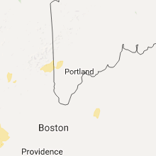
New Hampshire
| Local Time | Report Details |
|---|---|
| 5:43 PM EDT | Quarter sized hail reported near Hanover, NH, 70.6 miles SE of Burlington, VT |
| 6:54 PM EDT | Quarter sized hail reported near Madison, NH, 47.7 miles WNW of Portland, ME |
| 7:00 PM EDT | Golf Ball sized hail reported near Silver Lake, NH, 48.9 miles WNW of Portland, ME |
| 7:01 PM EDT | Ping Pong Ball sized hail reported near Madison, NH, 47.7 miles WNW of Portland, ME |
| 7:25 PM EDT | Quarter sized hail reported near Freedom, NH, 40.6 miles WNW of Portland, ME |
| 8:00 PM EDT | Trees on wire in merrimack county NH, 69.6 miles WSW of Portland, ME |
| 8:25 PM EDT | Large branches down in rockingham county NH, 73 miles N of Providence, RI |
| 9:10 PM EDT | Trees down on wires in strafford county NH, 47.5 miles SW of Portland, ME |
Massachusetts
| Local Time | Report Details |
|---|---|
| 6:05 PM EDT | Quarter sized hail reported near Hadley, MA, 68.6 miles WNW of Providence, RI, quarter size hail |
| 6:15 PM EDT | Strong winds blew down multiple large trees and damaged roof of building on prospect street in hampshire county MA, 55.4 miles ESE of Schenectady, NY |
| 6:30 PM EDT | Multiple trees down on wires on river road in franklin county MA, 70.7 miles ESE of Schenectady, NY |
| 6:39 PM EDT | Quarter sized hail reported near Williamsburg, MA, 68.5 miles ESE of Schenectady, NY, up to 1 inch |
| 6:43 PM EDT | Quarter sized hail reported near Williamsburg, MA, 68.5 miles ESE of Schenectady, NY, up to 1 inch |
| 7:16 PM EDT | Quarter sized hail reported near South Hadley, MA, 67.1 miles WNW of Providence, RI, pea to quarter size hail on marcel street |
| 7:39 PM EDT | Quarter sized hail reported near Westfield, MA, 72.8 miles WNW of Providence, RI, 0.75 to 1 inch hail |
| 7:45 PM EDT | Quarter sized hail reported near Westfield, MA, 72.8 miles WNW of Providence, RI, hail covered the ground |
| 7:46 PM EDT | Quarter sized hail reported near Westfield, MA, 72.8 miles WNW of Providence, RI, on folly drive |
| 7:47 PM EDT | Half Dollar sized hail reported near Westfield, MA, 72.8 miles WNW of Providence, RI, half dollar hail near provin mtn |
| 7:49 PM EDT | Quarter sized hail reported near Westfield, MA, 72.8 miles WNW of Providence, RI, on east mountain road |
| 8:00 PM EDT | Quarter sized hail reported near Agawam, MA, 64.5 miles WNW of Providence, RI |
| 8:00 PM EDT | Quarter sized hail reported near West Springfield, MA, 67 miles WNW of Providence, RI |
| 8:43 PM EDT | Quarter sized hail reported near Westfield, MA, 72.8 miles WNW of Providence, RI |
Maryland
| Local Time | Report Details |
|---|---|
| 6:37 PM EDT | Quarter sized hail reported near Glen Burnie, MD, 7.9 miles SSW of Baltimore, MD |
Colorado
| Local Time | Report Details |
|---|---|
| 5:38 PM MDT | Quarter sized hail reported near Yuma, CO, 3 miles SE of Yuma, CO, quarter hail... as well as heavy rainfall. |
| 6:58 PM MDT | Quarter sized hail reported near Stoneham, CO, 59.9 miles NW of Yuma, CO |
| 7:00 PM MDT | Ping Pong Ball sized hail reported near New Raymer, CO, 71.6 miles NW of Yuma, CO |
| 7:09 PM MDT | Ping Pong Ball sized hail reported near New Raymer, CO, 71.6 miles NW of Yuma, CO |
Connecticut
| Local Time | Report Details |
|---|---|
| 7:48 PM EDT | Quarter sized hail reported near New Milford, CT, 68.9 miles NNE of Brooklyn, NY |
| 7:50 PM EDT | Quarter sized hail reported near New Milford, CT, 68.7 miles NNE of Brooklyn, NY |
New Jersey
| Local Time | Report Details |
|---|---|
| 8:15 PM EDT | Quarter sized hail reported near Raritan, NJ, 35.2 miles WSW of Brooklyn, NY, time est. |
| 8:15 PM EDT | Quarter sized hail reported near Pittstown, NJ, 51.6 miles W of Brooklyn, NY, time est. |
| 8:15 PM EDT | Quarter sized hail reported near Flemington, NJ, 49.3 miles W of Brooklyn, NY, along the border of pittstown and raritan township. time estimated from radar. |
| 8:18 PM EDT | Quarter sized hail reported near Flemington, NJ, 47.4 miles WSW of Brooklyn, NY, fb imagery. time est. |
| 8:35 PM EDT | Quarter sized hail reported near Neshanic Station, NJ, 39.6 miles WSW of Brooklyn, NY, also nickel .88 same time from nearby in branchburg. |
Montana
| Local Time | Report Details |
|---|---|
| 9:21 PM MDT | 58 mph thunderstorm wind gust reported at deep creek raws site. time of occurrence is approximat in glacier county MT, 56.6 miles E of Whitefish, MT |
Connect with Interactive Hail Maps