

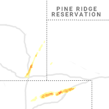
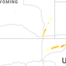
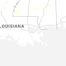
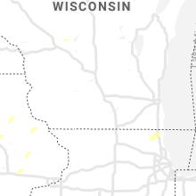
Hail Map for Monday, September 9, 2019

Number of Impacted Households on 9/9/2019
0
Impacted by 1" or Larger Hail
0
Impacted by 1.75" or Larger Hail
0
Impacted by 2.5" or Larger Hail
Square Miles of Populated Area Impacted on 9/9/2019
0
Impacted by 1" or Larger Hail
0
Impacted by 1.75" or Larger Hail
0
Impacted by 2.5" or Larger Hail


Cities Most Affected by Hail Storms of 9/9/2019
| Hail Size | Demographics of Zip Codes Affected | ||||||
|---|---|---|---|---|---|---|---|
| City | Count | Average | Largest | Pop Density | House Value | Income | Age |
Hail and Wind Damage Spotted on 9/9/2019
Filter by Report Type:Hail ReportsWind Reports
States Impacted
Georgia, South Carolina, Mississippi, Texas, Alabama, Virginia, North Carolina, Iowa, Louisiana, Florida, Kansas, New Mexico, Arkansas, Idaho, Illinois, ColoradoGeorgia
| Local Time | Report Details |
|---|---|
| 2:20 PM EDT | Ping Pong Ball sized hail reported near Vidalia, GA, 57.8 miles NNE of Douglas, GA, public reported quarter to ping pong ball sized hail at the intersection of hamilton rd and thompson pond rd. |
| 2:25 PM EDT | Quarter sized hail reported near Statesboro, GA, 53 miles NW of Savannah, GA, quarter size hail on middle ground road. |
| 2:25 PM EDT | A tree was reported down on orphans cemetary roa in dodge county GA, 52.8 miles NNW of Douglas, GA |
| 2:28 PM EDT | Tree reported down on the road on old glenwood r in wheeler county GA, 46.2 miles N of Douglas, GA |
| 2:30 PM EDT | Quarter sized hail reported near Statesboro, GA, 53.8 miles NW of Savannah, GA, a member of the public reported quarter-sized hail near the hwy 80/25 split. |
| 2:30 PM EDT | A report of a tree down on the side of the road near the hwy 80/25 spli in bulloch county GA, 53.8 miles NW of Savannah, GA |
| 2:35 PM EDT | Quarter sized hail reported near Statesboro, GA, 53.2 miles NW of Savannah, GA, a member of the public reported nickel to quarter-sized hail on akins pond road in the town of hopeulikit. |
| 2:39 PM EDT | Quarter sized hail reported near Statesboro, GA, 48.7 miles NW of Savannah, GA, a member of the public reported approximately quarter-sized hail near the intersection of lakeview and maria sorrell road. |
| 2:40 PM EDT | Quarter sized hail reported near Statesboro, GA, 49.6 miles NW of Savannah, GA, report of quarter-sized hail at the intersection of hunters way and lakeview rd. |
| 2:47 PM EDT | Tree reported down on lotts creek r in wheeler county GA, 43.5 miles NNE of Douglas, GA |
| 3:05 PM EDT | A tree was reported down on high 280 near sand grove baptist churc in dodge county GA, 38.2 miles NNW of Douglas, GA |
| 3:30 PM EDT | A 911 call center reported a tree down at old groveland rd and nevills groveland r in bulloch county GA, 40 miles W of Savannah, GA |
| 3:38 PM EDT | Log truck toppled over by wind on mistletoe road... near american legion roa in wilcox county GA, 41.6 miles NW of Douglas, GA |
| 3:40 PM EDT | A 911 call center reported a tree down at the 700 block of bowen lan in bulloch county GA, 50.1 miles WNW of Savannah, GA |
| 3:46 PM EDT | A tree was reported down on 215 south near sibbie roa in wilcox county GA, 35.6 miles NW of Douglas, GA |
| 3:49 PM EDT | Tree down near the intersection of louvale rd and jamestown r in chattahoochee county GA, 45.3 miles ESE of Auburn, AL |
South Carolina
| Local Time | Report Details |
|---|---|
| 3:45 PM EDT | Schp reported a tree down at the 2100 block of benton farm roa in colleton county SC, 47.9 miles WSW of Charleston, SC |
| 3:58 PM EDT | Quarter sized hail reported near Ruffin, SC, 51 miles WSW of Charleston, SC, a local business reports quarter-sized hail near the intersection of bells and low country highway. |
| 3:58 PM EDT | Reports of multiple trees down along bells highwa in colleton county SC, 51 miles WSW of Charleston, SC |
Mississippi
| Local Time | Report Details |
|---|---|
| 2:50 PM CDT | Trees down on hwy 11 @ beasly rd. there is also damage to moselle elementary schoo in jones county MS, 76.4 miles SE of Jackson, MS |
| 3:00 PM CDT | Trees reported down on old highway 84 loop road and pleasant grove roa in wayne county MS, 84.4 miles ESE of Jackson, MS |
| 4:02 PM CDT | Trees and power lines down in the mize are in smith county MS, 46.9 miles SE of Jackson, MS |
| 4:06 PM CDT | Tree down along hwy 84 east of collins at cutoff r in covington county MS, 58.4 miles SE of Jackson, MS |
| 4:30 PM CDT | Around 5-6 trees down... with some large limbs downed as well. mainly on rural roads near magee... south of mendenhall and near the braxton are in simpson county MS, 33.2 miles SSE of Jackson, MS |
| 4:52 PM CDT | Tree down on columbia avenu in jefferson davis county MS, 52.1 miles SSE of Jackson, MS |
| 5:22 PM CDT | Tree down on n old canton road. due to outflow winds and likely sub severe wind gust in madison county MS, 14.1 miles NNE of Jackson, MS |
| 5:35 PM CDT | Powerline down at gunter road and old natchez trace. due to outflow winds and likely sub severe wind gust in madison county MS, 21.9 miles NE of Jackson, MS |
| 5:40 PM CDT | Corrects previous tstm wnd dmg report from 2 sw livingston. few trees down on chapel hill road. 3 trees down on cedar hill roa in madison county MS, 16.2 miles N of Jackson, MS |
| 6:08 PM CDT | Tree down at stokes road and cloud roa in madison county MS, 21.5 miles N of Jackson, MS |
Texas
| Local Time | Report Details |
|---|---|
| 2:55 PM CDT | Tree blown down on hwy63 in newton county TX, 62.6 miles N of Beaumont, TX |
| 3:58 PM CDT | Asos station kcll easterwood field airport. aircraft was damage in brazos county TX, 82.3 miles NW of Houston, TX |
| 4:05 PM CDT | Report of utility poles down near the intersection of w carson st and finfeather rd. estimated wind gust of 60 mp in brazos county TX, 85.2 miles NW of Houston, TX |
| 4:27 PM CDT | At hearne municipal airport in robertson county TX, 68.8 miles ESE of Killeen, TX |
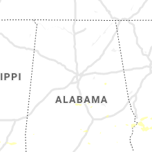
Alabama
| Local Time | Report Details |
|---|---|
| 3:07 PM CDT | Two trees down blocking the road on county road 2 in chilton county AL, 56.4 miles W of Auburn, AL |
| 5:32 PM CDT | Tree down on highland roa in clay county AL, 55.7 miles NNW of Auburn, AL |
Virginia
| Local Time | Report Details |
|---|---|
| 4:16 PM EDT | Tree reported down on the 100 block of hammond lan in augusta county VA, 70.7 miles SE of Elkins, WV |
| 4:28 PM EDT | Tree reported down on wilda roa in augusta county VA, 69.6 miles NE of Roanoke, VA |
| 4:42 PM EDT | Damage to garage roof and walls reported on the 2100 block of cold springs roa in augusta county VA, 67.8 miles NE of Roanoke, VA |
| 5:30 PM EDT | Tree reported down on tye brook highwa in nelson county VA, 60.2 miles ENE of Roanoke, VA |
| 5:31 PM EDT | Multiple trees reported down in the piney river are in nelson county VA, 58.9 miles ENE of Roanoke, VA |
| 5:35 PM EDT | Multiple trees reported down in the gladstone are in nelson county VA, 65.4 miles ENE of Roanoke, VA |
| 6:08 PM EDT | More than a dozen trees down in the oakville area... particularly on virginia highway 26 between oakville and appomattox. highway 26 near oakville was blocked going tow in appomattox county VA, 59.9 miles E of Roanoke, VA |
| 6:11 PM EDT | One large tree down on oakville roa in appomattox county VA, 60.6 miles ENE of Roanoke, VA |
| 6:20 PM EDT | Tree down at appomattox middle schoo in appomattox county VA, 61.5 miles E of Roanoke, VA |
| 6:53 PM EDT | One tree down on brookneal highway near rustburg. time estimated from rada in campbell county VA, 45.2 miles E of Roanoke, VA |
| 6:53 PM EDT | One large tree down in the 4000 block of brookneal highwa in campbell county VA, 46.3 miles E of Roanoke, VA |
| 6:53 PM EDT | Corrects previous tstm wnd dmg report from rustburg. one large tree down in the 4000 block of brookneal highwa in campbell county VA, 46.4 miles E of Roanoke, VA |
| 7:30 PM EDT | Trees down causing several power outages near the intersection of route 607 and big horn roa in brunswick county VA, 49.3 miles S of Richmond, VA |
North Carolina
| Local Time | Report Details |
|---|---|
| 4:40 PM EDT | Quarter sized hail reported near Murfreesboro, NC, 60.1 miles WSW of Virginia Beach, VA, pea to quarter size hail. |
| 4:50 PM EDT | A couple of trees down causing power outage in hertford county NC, 55.1 miles WSW of Virginia Beach, VA |
| 6:12 PM EDT | Damage to scotts hill market on hwy 17. time estimated by rada in pender county NC, 13 miles ENE of Wilmington, NC |
| 6:28 PM EDT | Report of strong winds with debris in the air at patsy lane and gordon road. dime sized hail also reporte in new hanover county NC, 6 miles ENE of Wilmington, NC |
| 6:32 PM EDT | Report of strong winds with debris in the air at patsy lane and gordon road. dime sized hail also reporte in new hanover county NC, 6 miles ENE of Wilmington, NC |
| 6:35 PM EDT | Minor roof damage to wilson cente in new hanover county NC, 0.4 miles NNW of Wilmington, NC |
| 6:42 PM EDT | Quarter sized hail reported near Wilmington, NC, 1.5 miles ENE of Wilmington, NC, quarter sized hail reported on pender avenue. |
| 6:57 PM EDT | Quarter sized hail reported near Kelly, NC, 26.8 miles NW of Wilmington, NC |
| 8:20 PM EDT | Several large trees down in columbus county NC, 41.8 miles WNW of Wilmington, NC |
Iowa
| Local Time | Report Details |
|---|---|
| 4:00 PM CDT | Law enforcement reports 4 to 6 inch tree limbs down in menlo. time estimated from rada in guthrie county IA, 40.9 miles W of Des Moines, IA |
| 4:08 PM CDT | Several 4 to 6 inch tree limbs dow in guthrie county IA, 40.9 miles W of Des Moines, IA |
| 4:35 PM CDT | 12 inch diameter tree snapped. relayed by dallas county emergency management. time estimated from rada in dallas county IA, 24.4 miles WNW of Des Moines, IA |
| 4:41 PM CDT | 120th and o ave in page county between stanton and bethesda. wind damage to 2 large metal buildings and various tree damag in page county IA, 51.5 miles ESE of Omaha, NE |
| 4:48 PM CDT | Telephone pole leaned over. no passing sign leaned over. delayed report. time estimated from rada in polk county IA, 18.3 miles N of Des Moines, IA |
| 5:01 PM CDT | Large tree down at 10th street and divisio in boone county IA, 36 miles NNW of Des Moines, IA |
| 5:11 PM CDT | Wall of a building pushed in 6 ft. damage to the walls and doors. contents inside blown around. also trees down. reported by ames police department. delayed report. tim in story county IA, 29.7 miles N of Des Moines, IA |
| 5:43 PM CDT | Report via social medi in story county IA, 28.3 miles NNE of Des Moines, IA |
| 5:46 PM CDT | Power pole broken at intersection of white pole road and adair stree in adair county IA, 37.5 miles W of Des Moines, IA |
| 5:50 PM CDT | 10 inch tree limb down on older tree. 3 to 4 inch tree limbs down on newer tree in story county IA, 31.2 miles NE of Des Moines, IA |
| 6:15 PM CDT | Several large tree limbs down throughout parkersburg and a couple trees reported to have fallen on homes. delayed report and time estimated by rada in butler county IA, 45.2 miles SSE of Mason City, IA |
| 6:25 PM CDT | Trained spotter reports tree damage around conrad and a couple power lines down. delayed report. time estimated from rada in grundy county IA, 58.1 miles NE of Des Moines, IA |
| 6:32 PM CDT | Large tree limb down on a home in clarksville. delayed report and time estimated by rada in butler county IA, 37 miles SE of Mason City, IA |
| 6:33 PM CDT | Several tree limbs... a few large ones... down throughout the town of shell rock. some were blocking street. delayed report and time estimated by rada in butler county IA, 44.9 miles SE of Mason City, IA |
| 7:02 PM CDT | Asos station kalo waterloo airpor in black hawk county IA, 54.4 miles NW of Cedar Rapids, IA |
| 7:07 PM CDT | Multiple trees down south of hubbard. one of the trees was 24 inches in diameter. spotter estimated wind gust up to 60 mp in hardin county IA, 49.6 miles NNE of Des Moines, IA |
| 7:15 PM CDT | Tree limb down across road in fayette county IA, 50.1 miles NNW of Cedar Rapids, IA |
| 7:27 PM CDT | Storm damage reported in black hawk county IA, 45.1 miles NW of Cedar Rapids, IA |
| 7:28 PM CDT | Report from mping: 1-inch tree limbs broken; shingles blown of in black hawk county IA, 51.6 miles NW of Cedar Rapids, IA |
| 7:30 PM CDT | Shed knocked over. time estimated from rada in winneshiek county IA, 57.7 miles SW of La Crosse, WI |
| 7:43 PM CDT | Asos station kmiw marshalltown airpor in marshall county IA, 51.3 miles NE of Des Moines, IA |
| 7:50 PM CDT | Social media report of estimated 60 mph gus in polk county IA, 8.8 miles WSW of Des Moines, IA |
| 8:40 PM CDT | Damage to mobile home skirting. 2.5 inch tree limbs down. time estimated by rada in black hawk county IA, 44.5 miles NW of Cedar Rapids, IA |
| 8:48 PM CDT | Report just northwest of la porte city on highway 218 near eagle roa in black hawk county IA, 38.1 miles NW of Cedar Rapids, IA |
| 9:15 PM CDT | Storm damage reported in buchanan county IA, 36.3 miles NNW of Cedar Rapids, IA |
| 9:15 PM CDT | Several small to medium size branches dow in buchanan county IA, 36.3 miles NNW of Cedar Rapids, IA |
| 9:15 PM CDT | Power pole down on carter ave west of brando in buchanan county IA, 30.8 miles NW of Cedar Rapids, IA |
| 12:00 AM CDT | Large tree dow in cedar county IA, 31.5 miles ESE of Cedar Rapids, IA |
| 12:21 AM CDT | Tree down on a power lin in jackson county IA, 52.1 miles E of Cedar Rapids, IA |
| 12:30 AM CDT | A few branches and limbs down. time estimated from rada in jones county IA, 37.3 miles E of Cedar Rapids, IA |
| 1:00 AM CDT | Trees down. time estimated from rada in jackson county IA, 58.6 miles ENE of Cedar Rapids, IA |
| 1:13 AM CDT | Iowa dot rwis at us 61 and highway 6 in jackson county IA, 51.6 miles E of Cedar Rapids, IA |
| 3:50 AM CDT | Reports trees down in neighborhood; strong winds over 60 mp in polk county IA, 4.9 miles S of Des Moines, IA |
| 3:55 AM CDT | Dsm public safety reports tree fell on power line causing power flashes in south des moine in polk county IA, 3.9 miles SSE of Des Moines, IA |
Louisiana
| Local Time | Report Details |
|---|---|
| 4:43 PM CDT | Tree down on route 175 southeast of mansfiel in de soto county LA, 35.1 miles S of Shreveport, LA |
| 4:45 PM CDT | Two trees dow in de soto county LA, 39.7 miles SSW of Shreveport, LA |
| 5:25 PM CDT | Tree down and power pole bent in neighborhood near the north gate of barksdale air force bas in bossier county LA, 1.9 miles NE of Shreveport, LA |
| 5:40 PM CDT | 5 adjacent power poles down along hwy 594 in ouachita parish just north of ouachita high school (about 3/4 mile north of i20) and at least 1 more on milhaven (parallels in ouachita county LA, 19 miles SSW of Bastrop, LA |
| 6:09 PM CDT | Tree down on burlington loop off of route 165. another tree caught on fire after taking a lightning strike on hog r in caldwell county LA, 60 miles SSW of Bastrop, LA |
| 6:37 PM CDT | Quarter sized hail reported near Prairieville, LA, 58.5 miles WNW of New Orleans, LA, penny to quarter size hail was reported in bullion crossing neighborhood in prairieville. |
Florida
| Local Time | Report Details |
|---|---|
| 6:15 PM EDT | Trained spotter reports estimated wind gusts to 50 mp in marion county FL, 51.7 miles NW of Orlando, FL |
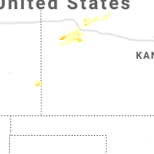
Kansas
| Local Time | Report Details |
|---|---|
| 5:30 PM CDT | Quarter sized hail reported near Oakley, KS, 20.7 miles SSE of Colby, KS, hail was measured to be 1.125 inches (one and an eighth inch). |
| 7:16 PM CDT | Half Dollar sized hail reported near Winona, KS, 35.8 miles SSW of Colby, KS, time estimated by radar. |
| 7:49 PM CDT | Quarter sized hail reported near Winona, KS, 35.6 miles SSW of Colby, KS, time estimated by radar. |
| 8:38 PM CDT | Quarter sized hail reported near Wallace, KS, 38.5 miles SSW of Colby, KS, dime to quarter size hail covering the ground to a depth of at least 1 inch near the intersection of county road 160 and k25 at 738 pm mdt... 838 pm cdt. |
New Mexico
| Local Time | Report Details |
|---|---|
| 5:05 PM MDT | White sands missile range - stallion wi in socorro county NM, 101 miles S of Albuquerque, NM |
Arkansas
| Local Time | Report Details |
|---|---|
| 7:50 PM CDT | Trees and powerlines down with some roads blocked in the are in desha county AR, 66.3 miles NNE of Bastrop, LA |
| 7:52 PM CDT | A tree fell on two cars at dermott villa in chicot county AR, 58.7 miles NNE of Bastrop, LA |
| 7:52 PM CDT | A tree down between two houses on south knox stree in chicot county AR, 58.7 miles NNE of Bastrop, LA |
Idaho
| Local Time | Report Details |
|---|---|
| 6:56 PM MDT | Half Dollar sized hail reported near Twin Falls, ID, 8.7 miles SW of Twin Falls, ID |
| 7:01 PM MDT | Quarter sized hail reported near Twin Falls, ID, 6.5 miles SW of Twin Falls, ID |
| 7:03 PM MDT | Quarter sized hail reported near Twin Falls, ID, 5.6 miles SSW of Twin Falls, ID |
| 7:25 PM MDT | Ping Pong Ball sized hail reported near Kimberly, ID, 7.4 miles ESE of Twin Falls, ID, hail picture in the kimberly/hansen area on twitter. |
| 7:38 PM MDT | Quarter sized hail reported near Eden, ID, 13.6 miles ENE of Twin Falls, ID |
| 7:46 PM MDT | Quarter sized hail reported near Hazelton, ID, 19.5 miles ENE of Twin Falls, ID, hail at north wilson fire reported by fire crew. |
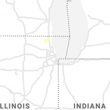
Illinois
| Local Time | Report Details |
|---|---|
| 1:25 AM CDT | Large tree down on highway 2 in jo daviess county IL, 67.1 miles SW of Madison, WI |
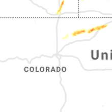
Colorado
| Local Time | Report Details |
|---|---|
| 3:13 AM MDT | Quarter sized hail reported near Merino, CO, 53.3 miles NW of Yuma, CO |
Connect with Interactive Hail Maps