

Hail Map for Tuesday, April 28, 2020

Number of Impacted Households on 4/28/2020
0
Impacted by 1" or Larger Hail
0
Impacted by 1.75" or Larger Hail
0
Impacted by 2.5" or Larger Hail
Square Miles of Populated Area Impacted on 4/28/2020
0
Impacted by 1" or Larger Hail
0
Impacted by 1.75" or Larger Hail
0
Impacted by 2.5" or Larger Hail


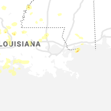


Cities Most Affected by Hail Storms of 4/28/2020
| Hail Size | Demographics of Zip Codes Affected | ||||||
|---|---|---|---|---|---|---|---|
| City | Count | Average | Largest | Pop Density | House Value | Income | Age |
| Marlow, OK | 5 | 2.20 | 2.75 | 39 | $50k | $28.9k | 41.5 |
| Yukon, OK | 4 | 2.25 | 2.75 | 529 | $87k | $49.1k | 35.3 |
| Chickasha, OK | 3 | 2.42 | 3.75 | 123 | $53k | $28.1k | 37.5 |
| Bryson, TX | 2 | 1.88 | 2.00 | 3 | $37k | $28.3k | 39.3 |
| Henderson, TX | 2 | 1.75 | 1.75 | 60 | $65k | $32.4k | 37.6 |
| Windthorst, TX | 1 | 2.75 | 2.75 | 4 | $73k | $36.8k | 36.8 |
| Cushing, OK | 1 | 2.75 | 2.75 | 64 | $53k | $28.5k | 39.3 |
| Haileyville, OK | 1 | 2.75 | 2.75 | 0 | $35k | $27.9k | 39.8 |
| Pocasset, OK | 1 | 2.50 | 2.50 | 7 | $53k | $30.0k | 37.9 |
| Orlando, OK | 1 | 2.50 | 2.50 | 4 | $35k | $35.9k | 41.8 |
| Comanche, OK | 1 | 2.00 | 2.00 | 23 | $41k | $29.9k | 40.9 |
| Cleburne, TX | 1 | 2.00 | 2.00 | 156 | $0k | $0.0k | 36.8 |
| Eastland, TX | 1 | 2.00 | 2.00 | 41 | $49k | $29.6k | 41.8 |
| Duncan, OK | 1 | 2.00 | 2.00 | 88 | $61k | $31.6k | 40.0 |
| Bellevue, TX | 1 | 2.00 | 2.00 | 5 | $38k | $33.9k | 46.2 |
| Crescent, OK | 1 | 1.75 | 1.75 | 19 | $54k | $30.6k | 41.6 |
| Bowie, TX | 1 | 1.75 | 1.75 | 26 | $56k | $31.5k | 43.2 |
| Nacogdoches, TX | 1 | 1.75 | 1.75 | 58 | $86k | $28.5k | 30.7 |
| Wichita Falls, TX | 1 | 1.75 | 1.75 | 107 | $78k | $43.0k | 37.8 |
| Meridian, OK | 1 | 1.75 | 1.75 | 7 | $33k | $21.9k | 49.0 |
| Maud, OK | 1 | 1.75 | 1.75 | 16 | $28k | $26.1k | 37.9 |
| Stillwater, OK | 1 | 1.75 | 1.75 | 215 | $101k | $28.0k | 25.8 |
| Shawnee, OK | 1 | 1.75 | 1.75 | 205 | $80k | $35.3k | 35.4 |
| Breckenridge, TX | 1 | 1.75 | 1.75 | 16 | $45k | $29.6k | 39.3 |
| Stringtown, OK | 1 | 1.75 | 1.75 | 1 | $41k | $25.8k | 45.4 |
| Marshall, OK | 1 | 1.75 | 1.75 | 3 | $22k | $28.1k | 44.1 |
| Clarksville, TX | 1 | 1.75 | 1.75 | 17 | $33k | $25.5k | 46.2 |
| Miami, OK | 1 | 1.75 | 1.75 | 102 | $52k | $27.8k | 37.4 |
| Pittsburg, OK | 1 | 1.75 | 1.75 | 2 | $26k | $20.5k | 44.3 |
| Stonewall, OK | 1 | 1.75 | 1.75 | 10 | $39k | $26.7k | 42.2 |
| Bartlesville, OK | 1 | 1.75 | 1.75 | 122 | $37k | $25.8k | 36.8 |
Hail and Wind Damage Spotted on 4/28/2020
Filter by Report Type:Hail ReportsWind Reports
States Impacted
Texas, Arkansas, Louisiana, Montana, Mississippi, Kansas, Illinois, Oklahoma, MissouriTexas
| Local Time | Report Details |
|---|---|
| 7:48 AM CDT | Quarter sized hail reported near Hallsville, TX, 51.6 miles W of Shreveport, LA, hail report off clark taylor road in hallsville. |
| 7:50 AM CDT | Quarter sized hail reported near Marshall, TX, 29.5 miles W of Shreveport, LA, 1†hail off clark taylor road in hallsville... no wind to speak of... .37†rain. |
| 8:00 AM CDT | Quarter sized hail reported near Marshall, TX, 35.5 miles W of Shreveport, LA, reported at texas department of public safety office off the northern loop in marshall. |
| 11:48 AM CDT | Tree down in mount verno in franklin county TX, 95.4 miles ENE of Dallas, TX |
| 3:38 PM CDT | Quarter sized hail reported near Nacogdoches, TX, 15.5 miles NE of Lufkin, TX, reported in the woden community. |
| 3:38 PM CDT | Golf Ball sized hail reported near Nacogdoches, TX, 15.5 miles NE of Lufkin, TX, public submits photos of hail ranging up to golf ball size in the woden community via broadcast media social media page. |
| 4:25 PM CDT | Quarter sized hail reported near Nacogdoches, TX, 23.4 miles N of Lufkin, TX, reported near the central heights community. |
| 4:30 PM CDT | Quarter sized hail reported near Nacogdoches, TX, 26.8 miles NNE of Lufkin, TX, reported near the appleby community. |
| 5:45 PM CDT | Golf Ball sized hail reported near Henderson, TX, 50.1 miles N of Lufkin, TX, reported on fm road 839 near the compton community. |
| 5:50 PM CDT | Golf Ball sized hail reported near Henderson, TX, 50.8 miles NNW of Lufkin, TX, hail reported in the goodsprings community. |
| 5:51 PM CDT | Ping Pong Ball sized hail reported near Henderson, TX, 52.3 miles NNW of Lufkin, TX, reported on county road 475 south of the price community. |
| 6:30 PM CDT | Quarter sized hail reported near Troup, TX, 59.8 miles NNW of Lufkin, TX, penny to quarter size hail reported near troup. |
| 9:20 PM CDT | Baseball sized hail reported near Windthorst, TX, 23.6 miles S of Wichita Falls, TX, time estimated from radar. |
| 9:28 PM CDT | Golf Ball sized hail reported near Wichita Falls, TX, 9.7 miles SSE of Wichita Falls, TX, nwschat report... relayed by em. |
| 9:32 PM CDT | Golf Ball sized hail reported near Breckenridge, TX, 53 miles NE of Abilene, TX |
| 9:45 PM CDT | Golf Ball sized hail reported near Bowie, TX, 39.9 miles SSE of Wichita Falls, TX |
| 9:54 PM CDT | Ping Pong Ball sized hail reported near Bellevue, TX, 33.7 miles SE of Wichita Falls, TX, spotternetwork report. |
| 9:57 PM CDT | Storm damage reported in cooke county TX, 62 miles NNW of Dallas, TX |
| 10:00 PM CDT | Ping Pong Ball sized hail reported near Breckenridge, TX, 50.9 miles ENE of Abilene, TX |
| 10:01 PM CDT | Quarter sized hail reported near Bellevue, TX, 33.7 miles SE of Wichita Falls, TX |
| 10:02 PM CDT | Hen Egg sized hail reported near Bellevue, TX, 33.8 miles ESE of Wichita Falls, TX |
| 10:08 PM CDT | Golf Ball sized hail reported near Bryson, TX, 52 miles S of Wichita Falls, TX |
| 10:10 PM CDT | Golf Ball sized hail reported near Clarksville, TX, 71.7 miles WSW of Nashville, AR, ping pong to golf ball size hail reported in the dimple community. |
| 10:10 PM CDT | Hen Egg sized hail reported near Bryson, TX, 52 miles S of Wichita Falls, TX, photo of approximately 2 inch hail on social media. |
| 10:16 PM CDT | Quarter sized hail reported near Jacksboro, TX, 57.6 miles SSE of Wichita Falls, TX, report from mping: quarter (1.00 in.). |
| 10:27 PM CDT | Storm damage reported in denton county TX, 42.9 miles NNW of Dallas, TX |
| 10:27 PM CDT | Ping Pong Ball sized hail reported near Wichita Falls, TX, 10.6 miles SE of Wichita Falls, TX |
| 10:35 PM CDT | Near hwy 380 and 37 in denton county TX, 36.7 miles NNW of Dallas, TX |
| 10:45 PM CDT | Quarter sized hail reported near Alvord, TX, 60.1 miles SE of Wichita Falls, TX, report from mping: quarter (1.00 in.). |
| 10:45 PM CDT | Near fm 423 and hwy 38 in denton county TX, 30.8 miles N of Dallas, TX |
| 11:00 PM CDT | Ping Pong Ball sized hail reported near Decatur, TX, 57.8 miles NW of Dallas, TX, report from mping: ping pong ball (1.50 in.). |
| 11:12 PM CDT | Dfw asos 50 kt in tarrant county TX, 16.5 miles WNW of Dallas, TX |
| 11:12 PM CDT | Storm damage reported in collin county TX, 16.1 miles NNE of Dallas, TX |
| 11:17 PM CDT | Hen Egg sized hail reported near Eastland, TX, 54 miles E of Abilene, TX |
| 11:25 PM CDT | Report of large tree down on s. runnels s in bowie county TX, 54.2 miles SW of Nashville, AR |
| 11:25 PM CDT | Report of tree down on fm 2735 just north of de kal in bowie county TX, 53.4 miles WSW of Nashville, AR |
| 11:30 PM CDT | Report from mping: 1-inch tree limbs broken; shingles blown of in hunt county TX, 61.7 miles ENE of Dallas, TX |
| 11:32 PM CDT | Several trees down in hook in bowie county TX, 41.7 miles SW of Nashville, AR |
| 11:44 PM CDT | Trl asos 50 kt in kaufman county TX, 31 miles E of Dallas, TX |
| 11:45 PM CDT | Cwop sit in dallas county TX, 3 miles NE of Dallas, TX |
| 11:48 PM CDT | Corrects time of previous tstm wnd dmg report from mount vernon. tree down in mount verno in franklin county TX, 95.4 miles ENE of Dallas, TX |
| 11:54 PM CDT | Measured with handheld anemomete in dallas county TX, 16.8 miles ESE of Dallas, TX |
| 11:54 PM CDT | Measured with handheld anemomete in dallas county TX, 16.8 miles ESE of Dallas, TX |
| 12:04 AM CDT | Storm damage reported in johnson county TX, 48.4 miles WSW of Dallas, TX |
| 12:12 AM CDT | Quarter sized hail reported near Arlington, TX, 20 miles WSW of Dallas, TX |
| 12:16 AM CDT | Storm damage reported in johnson county TX, 45.6 miles SW of Dallas, TX |
| 12:16 AM CDT | Mping repor in cass county TX, 61.8 miles WNW of Shreveport, LA |
| 12:17 AM CDT | Handheld anemomete in van zandt county TX, 53 miles E of Dallas, TX |
| 12:20 AM CDT | At i-20 and fm 6 in van zandt county TX, 52.5 miles ESE of Dallas, TX |
| 12:20 AM CDT | 15 foot tall tree uproote in henderson county TX, 51.5 miles SE of Dallas, TX |
| 12:29 AM CDT | Hen Egg sized hail reported near Cleburne, TX, 47.8 miles SW of Dallas, TX |
| 12:31 AM CDT | Tree down with power lines at fm 726 and myrtle roa in upshur county TX, 61.5 miles WNW of Shreveport, LA |
| 12:31 AM CDT | Tree down on power lines at hwy 154 and bentley roa in upshur county TX, 59.4 miles WNW of Shreveport, LA |
| 12:36 AM CDT | Multiple trees down along hwy 80 in wood count in wood county TX, 76.5 miles E of Dallas, TX |
| 12:43 AM CDT | Half Dollar sized hail reported near Cresson, TX, 47.7 miles WSW of Dallas, TX |
| 12:50 AM CDT | Half Dollar sized hail reported near Lindale, TX, 82.9 miles ESE of Dallas, TX, half dollar size hail in lindale. |
| 12:50 AM CDT | Trees and power lines down on runnels roa in harrison county TX, 37.8 miles W of Shreveport, LA |
| 12:57 AM CDT | Trees down on fm 968 at lancing switch roa in harrison county TX, 51.2 miles W of Shreveport, LA |
| 12:58 AM CDT | Quarter sized hail reported near Kemp, TX, 46.5 miles SE of Dallas, TX |
| 12:58 AM CDT | Multiple trees down on hwy 22 near brando in hill county TX, 51.8 miles S of Dallas, TX |
| 1:00 AM CDT | Trees down on fm 2625 west near 5 notch roa in harrison county TX, 33.8 miles W of Shreveport, LA |
| 1:01 AM CDT | 59 mph wind gust measured at tyler pounds fiel in smith county TX, 80.8 miles NNW of Lufkin, TX |
| 1:01 AM CDT | Half Dollar sized hail reported near Corsicana, TX, 52.4 miles SSE of Dallas, TX, report from mping: half dollar (1.25 in.). |
| 1:02 AM CDT | Quarter sized hail reported near Godley, TX, 45.4 miles WSW of Dallas, TX, report from mping: quarter (1.00 in.). |
| 1:03 AM CDT | Report of tree down us 84 in rekla in cherokee county TX, 39.1 miles NNW of Lufkin, TX |
| 1:08 AM CDT | Quarter sized hail reported near Tyler, TX, 80 miles NNW of Lufkin, TX, quarter size hail reported on the northwest side of tyler. |
| 1:16 AM CDT | Ping Pong Ball sized hail reported near Kilgore, TX, 68.9 miles W of Shreveport, LA, ping pong ball size hail in laird hill. |
| 1:21 AM CDT | Quarter sized hail reported near Cleburne, TX, 46 miles SW of Dallas, TX |
| 1:23 AM CDT | Tree down on fm850 just east of overto in rusk county TX, 65.3 miles NNW of Lufkin, TX |
| 1:25 AM CDT | Trees down across fm1 in panola county TX, 42.8 miles SW of Shreveport, LA |
| 1:25 AM CDT | Trees down across highway 31 in panola county TX, 45.6 miles SW of Shreveport, LA |
| 1:26 AM CDT | Reports of tree down on sh 135 ne of overto in rusk county TX, 66.3 miles NNW of Lufkin, TX |
| 1:27 AM CDT | Quarter sized hail reported near Bluff Dale, TX, 77 miles WSW of Dallas, TX, report from mping: quarter (1.00 in.). |
| 1:29 AM CDT | Reports of power lines down on pinkston stree in rusk county TX, 63.2 miles NNW of Lufkin, TX |
| 1:30 AM CDT | Report of pine tree across road at fm 3053 and cr 111 in rusk county TX, 68.4 miles NNW of Lufkin, TX |
| 1:32 AM CDT | Quarter sized hail reported near Longview, TX, 57.4 miles W of Shreveport, LA |
| 1:33 AM CDT | Half Dollar sized hail reported near Killeen, TX, 3.4 miles SSE of Killeen, TX |
| 1:34 AM CDT | Quarter sized hail reported near Killeen, TX, 4.9 miles SSE of Killeen, TX |
| 1:34 AM CDT | Measured at corsicana aso in navarro county TX, 56.5 miles SSE of Dallas, TX |
| 1:35 AM CDT | Several trees dow in panola county TX, 49.4 miles SW of Shreveport, LA |
| 1:37 AM CDT | Reports of trees down with power lines across the roa in smith county TX, 81.3 miles ESE of Dallas, TX |
| 1:44 AM CDT | Numerous trees were down throughout much of cherokee count in cherokee county TX, 49.4 miles NNW of Lufkin, TX |
| 1:45 AM CDT | Reports of large tree across road on fm 2867 near pine hil in rusk county TX, 52.4 miles N of Lufkin, TX |
| 1:45 AM CDT | Reports of tree down on residence on fm 1798 east of us 25 in rusk county TX, 46 miles N of Lufkin, TX |
| 1:50 AM CDT | Half Dollar sized hail reported near Stephenville, TX, 83.2 miles NNW of Killeen, TX, report from mping: half dollar (1.25 in.). |
| 2:01 AM CDT | Quarter sized hail reported near Stephenville, TX, 77.7 miles NNW of Killeen, TX, report from mping: quarter (1.00 in.). |
| 2:01 AM CDT | Half Dollar sized hail reported near Whitney, TX, 63.3 miles NNE of Killeen, TX |
| 2:10 AM CDT | A tree was blown down on highway 7 west of cente in shelby county TX, 37.1 miles NE of Lufkin, TX |
| 2:11 AM CDT | Powerlines down near 8876 east highway 2 in houston county TX, 37.6 miles W of Lufkin, TX |
| 2:12 AM CDT | Tree down on fm 228 northeast of grapelan in houston county TX, 45.9 miles WNW of Lufkin, TX |
| 2:14 AM CDT | Powerline blown down on cr 1710 near percill in houston county TX, 42.7 miles WNW of Lufkin, TX |
| 2:32 AM CDT | A large tree was blown down in mila in sabine county TX, 51.7 miles E of Lufkin, TX |
| 2:44 AM CDT | Trees were downed on highway 10 in san augustine county TX, 28.5 miles E of Lufkin, TX |
| 2:50 AM CDT | A tree was downed on fm 2109 near ora church roa in angelina county TX, 17.8 miles ESE of Lufkin, TX |
| 3:41 AM CDT | 52kts measured at robert gray army airfiel in bell county TX, 6.9 miles WSW of Killeen, TX |
| 4:40 AM CDT | Storm damage reported in burleson county TX, 72.9 miles ESE of Killeen, TX |
| 5:28 AM CDT | Storm damage reported in galveston county TX, 25.9 miles SE of Houston, TX |
| 5:43 AM CDT | Measured at the crenshaw magnet school in crystal beac in galveston county TX, 46.8 miles ESE of Houston, TX |
Arkansas
| Local Time | Report Details |
|---|---|
| 9:33 AM CDT | Quarter sized hail reported near Ashdown, AR, 31.1 miles SW of Nashville, AR, reported in the arden community via social media. |
| 9:45 AM CDT | Ping Pong Ball sized hail reported near Nashville, AR, 8.2 miles NW of Nashville, AR, corrects previous hail report from center point. reported at the center point store. |
| 9:58 AM CDT | Ping Pong Ball sized hail reported near Nashville, AR, 8.2 miles NW of Nashville, AR, reported at the center point store. |
| 10:09 AM CDT | Ping Pong Ball sized hail reported near Nashville, AR, 8.2 miles NW of Nashville, AR, report of ping pong size hail. |
| 8:40 PM CDT | Tree down across highway 2 in franklin county AR, 37.1 miles ENE of Fort Smith, AR |
| 8:45 PM CDT | A tree was blown down on highway 43 northwest of jaspe in newton county AR, 77.2 miles S of Springfield, MO |
| 8:59 PM CDT | Storm damage reported in sebastian county AR, 14.6 miles SE of Fort Smith, AR |
| 9:13 PM CDT | Power lines and trees down in barlin in sebastian county AR, 7.8 miles ESE of Fort Smith, AR |
| 9:15 PM CDT | Storm damage reported in logan county AR, 40.1 miles E of Fort Smith, AR |
| 9:26 PM CDT | Tree limb down on ware road in sebastian county AR, 14.6 miles SE of Fort Smith, AR |
| 9:27 PM CDT | Trees were blown down on highway 80 east of waldron. other trees were blown down in various locations around the count in scott county AR, 43.8 miles SE of Fort Smith, AR |
| 9:41 PM CDT | A tree fell on a hous in pope county AR, 60.8 miles NW of Little Rock, AR |
| 10:00 PM CDT | Trees were blown down at cove on several county roads and on u. s. highway 71 sout in polk county AR, 46.8 miles NW of Nashville, AR |
| 10:10 PM CDT | A tree was blown dow in montgomery county AR, 43 miles NNE of Nashville, AR |
| 10:13 PM CDT | A tree was blown down across highway 9 at choctaw roa in perry county AR, 35.5 miles NW of Little Rock, AR |
| 10:13 PM CDT | A tree was blown down across houston avenue on the east side of perryvill in perry county AR, 34.9 miles WNW of Little Rock, AR |
| 10:13 PM CDT | A tree was blown down blocking all lanes of hwy in conway county AR, 36.7 miles NW of Little Rock, AR |
| 10:15 PM CDT | Multiple gas pumps sustained wind damag in conway county AR, 38.8 miles NW of Little Rock, AR |
| 10:25 PM CDT | Storm damage reported in independence county AR, 79.5 miles NNE of Little Rock, AR |
| 10:30 PM CDT | A tree was blown down on hwy 394 blocking the west bound lan in independence county AR, 79.1 miles NNE of Little Rock, AR |
| 10:34 PM CDT | Trees down along hwy 71 in gillha in sevier county AR, 30.7 miles WNW of Nashville, AR |
| 10:36 PM CDT | Tree down along hwy 71 near de quee in sevier county AR, 28.6 miles WNW of Nashville, AR |
| 10:36 PM CDT | Quarter sized hail reported near De Queen, AR, 29.2 miles WNW of Nashville, AR, quarter size hail reported in de queen. |
| 10:41 PM CDT | A large power line was blown down at albert pike road and the mlk bypas in garland county AR, 47.7 miles WSW of Little Rock, AR |
| 10:44 PM CDT | Trees down along hwy 24 between horatio and lockesbur in sevier county AR, 22 miles W of Nashville, AR |
| 10:49 PM CDT | A carport was damaged from strong thunderstorm wind in faulkner county AR, 26.2 miles NNE of Little Rock, AR |
| 10:53 PM CDT | Ping Pong Ball sized hail reported near Searcy, AR, 41.7 miles NNE of Little Rock, AR, ping pong ball sized hail fell... and winds were estimated at 70 mph. |
| 10:53 PM CDT | Storm damage reported in craighead county AR, 67.4 miles NW of Memphis, TN |
| 10:55 PM CDT | A tree was blown down on a hous in saline county AR, 21.3 miles SW of Little Rock, AR |
| 10:56 PM CDT | Quarter sized hail reported near Little Rock, AR, 8.4 miles W of Little Rock, AR, quarter sized hail was falling in west little rock. |
| 10:58 PM CDT | Quarter sized hail reported near Sherwood, AR, 10.1 miles NNE of Little Rock, AR |
| 11:00 PM CDT | Trees down along hwy 278 at messer cree in howard county AR, 11 miles NW of Nashville, AR |
| 11:00 PM CDT | A portion of a privacy fence was blown dow in pulaski county AR, 13.4 miles NE of Little Rock, AR |
| 11:00 PM CDT | A tree was blown down on hwy 270... just west of mt. ida in montgomery county AR, 44.3 miles NNE of Nashville, AR |
| 11:00 PM CDT | A large tree was blown into a home at 810 park avenue in jonesboro. residents were trapped with minor injurie in craighead county AR, 60.3 miles NW of Memphis, TN |
| 11:00 PM CDT | Trees were blown dow in pike county AR, 11.4 miles N of Nashville, AR |
| 11:01 PM CDT | Large tree on hous in craighead county AR, 60.3 miles NW of Memphis, TN |
| 11:03 PM CDT | Quarter sized hail reported near Jacksonville, AR, 13.2 miles NNE of Little Rock, AR |
| 11:04 PM CDT | Storm damage reported in lonoke county AR, 21 miles NE of Little Rock, AR |
| 11:04 PM CDT | Tree down on a vehicle along harding road at hwy 27 in howard county AR, 5.1 miles NW of Nashville, AR |
| 11:04 PM CDT | Report of trees down on gas line north of nashville on hwy 2 in howard county AR, 1.3 miles NE of Nashville, AR |
| 11:08 PM CDT | A tree was blown down blocking one lane of hwy 36 in white county AR, 28.5 miles NE of Little Rock, AR |
| 11:08 PM CDT | A tree was blown down across the southbound outside lane of u.s. hwy 6 in white county AR, 43.4 miles NE of Little Rock, AR |
| 11:16 PM CDT | Multiple trees were blown down throughout the count in pulaski county AR, 4.7 miles WSW of Little Rock, AR |
| 11:16 PM CDT | Tree down on hwy 32 at millwood da in hempstead county AR, 14.8 miles SSW of Nashville, AR |
| 11:25 PM CDT | 1-inch tree limbs broken and shingles blown off roo in hempstead county AR, 16.6 miles SE of Nashville, AR |
| 4:26 AM UTC | Trees were blown down on several roads in arkadelphia and in various parts of the count in clark county AR, 46.1 miles ENE of Nashville, AR |
| 11:27 PM CDT | Quarter sized hail reported near Hope, AR, 21.2 miles SE of Nashville, AR, quarter size hail reported near oakhaven. |
| 11:31 PM CDT | A power line was blown down blocking all lanes of hwy 1 in prairie county AR, 47 miles ENE of Little Rock, AR |
| 11:33 PM CDT | Quarter sized hail reported near Hope, AR, 24.2 miles SE of Nashville, AR, quarter size hail reported in hope by arkansas state police. |
| 4:40 AM UTC | A union pacific mesonet site measured a 67 mph wind gus in monroe county AR, 63.7 miles ENE of Little Rock, AR |
| 11:45 PM CDT | Storm damage reported in mississippi county AR, 56 miles N of Memphis, TN |
| 11:50 PM CDT | Tree down along hwy 371 between rosston and willisvill in nevada county AR, 42.6 miles SE of Nashville, AR |
| 11:54 PM CDT | A tree was blown down on highway 302 just outside of the city limit in monroe county AR, 55 miles E of Little Rock, AR |
| 11:55 PM CDT | Estimated 60 mph wind gus in lafayette county AR, 45.2 miles SSE of Nashville, AR |
| 11:59 PM CDT | A tree was blown down at 36th and el in jefferson county AR, 39.9 miles SSE of Little Rock, AR |
| 4:59 AM UTC | Trees and powerlines were blown down across hwy 128 three miles south of sparkma in dallas county AR, 57.5 miles E of Nashville, AR |
| 12:01 AM CDT | A few trees down in fouk in miller county AR, 47.5 miles S of Nashville, AR |
| 12:35 AM CDT | Tree down on power lines along hwy 79 sparking an electrical fir in columbia county AR, 49.3 miles NE of Shreveport, LA |
| 12:40 AM CDT | A few trees reported down in smackove in union county AR, 62.4 miles NW of Bastrop, LA |
| 12:41 AM CDT | Trees were blown down south of star city in lincoln county AR, 63.6 miles SSE of Little Rock, AR |
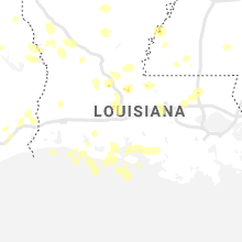
Louisiana
| Local Time | Report Details |
|---|---|
| 2:35 PM CDT | Tree down on powerline at 1044 bill phillips r in calcasieu county LA, 30.9 miles NE of Beaumont, TX |
| 3:05 PM CDT | Wind damage to two houses. one had roof removed. another had large carport lifted producing roof damag in beauregard county LA, 37.8 miles NE of Beaumont, TX |
| 3:15 PM CDT | Emergency manager reports several trees down on carver road/tunica trace. time estimated by rada in west feliciana county LA, 59 miles NE of Lafayette, LA |
| 5:04 PM CDT | Media reports tin blown off roofs and trees down about 6 miles north of livingston. time estimated by rada in livingston county LA, 59.5 miles NW of New Orleans, LA |
| 5:37 PM CDT | Media reports trees and powerlines down in hammond. time estimated by rada in tangipahoa county LA, 44.6 miles NNW of New Orleans, LA |
| 5:42 PM CDT | Multiple large oak trees uprooted and fell on structures at loranger high schoo in tangipahoa county LA, 51 miles NNW of New Orleans, LA |
| 7:45 PM CDT | Emergency manager reports several trees down on roads in schriever and gray. time estimated by rada in terrebonne county LA, 47.5 miles WSW of New Orleans, LA |
| 8:02 PM CDT | Emergency manager reports trees down in the houma area. time estimated by rada in terrebonne county LA, 45.5 miles WSW of New Orleans, LA |
| 9:00 PM CDT | Emergency manager reports several trees down... patios blown... poles and wires down in belle chasse. time estimated by rada in plaquemines county LA, 8.5 miles SSE of New Orleans, LA |
| 9:05 PM CDT | Emergency manager reports power poles and lines down and roof blown off onto highway 23. time estimated by rada in plaquemines county LA, 12.2 miles S of New Orleans, LA |
| 12:36 AM CDT | Quarter sized hail reported near Springhill, LA, 37.8 miles NNE of Shreveport, LA, quarter size hail in springhill. |
| 12:42 AM CDT | Tree down along 371 in sarept in webster county LA, 31.1 miles NNE of Shreveport, LA |
| 1:05 AM CDT | Several trees down along hwy 79 in home in claiborne county LA, 44.3 miles ENE of Shreveport, LA |
| 1:05 AM CDT | Tree down across hwy 3 on the north side of bossier cit in bossier county LA, 8 miles N of Shreveport, LA |
| 1:10 AM CDT | Tree down across hwy 518 east of minde in webster county LA, 34 miles ENE of Shreveport, LA |
| 1:15 AM CDT | Tree down on a car along hwy 16 in webster county LA, 19.8 miles E of Shreveport, LA |
| 1:15 AM CDT | Tree down on a home on dudley drive with several other trees down across the cit in caddo county LA, 3.1 miles S of Shreveport, LA |
| 1:24 AM CDT | Quarter sized hail reported near Shreveport, LA, 3.1 miles S of Shreveport, LA, quarter size hail reported. |
| 1:35 AM CDT | Several trees dow in union county LA, 28.5 miles W of Bastrop, LA |
| 1:40 AM CDT | Trees down across bethel roa in de soto county LA, 18.4 miles S of Shreveport, LA |
| 1:40 AM CDT | Corrects time of previous tstm wnd dmg report from 10 wnw sterlington. several trees and power lines dow in union county LA, 18.6 miles W of Bastrop, LA |
| 1:42 AM CDT | A car waiting for the road to be cleared of a fallen tree had another tree fall on i in union county LA, 18.6 miles W of Bastrop, LA |
| 1:50 AM CDT | Trees dow in ouachita county LA, 30.7 miles WSW of Bastrop, LA |
| 1:50 AM CDT | Trees down across hwy. 18 in ouachita county LA, 31.9 miles SW of Bastrop, LA |
| 1:55 AM CDT | Several trees dow in red river county LA, 43 miles SE of Shreveport, LA |
| 1:57 AM CDT | Trees dow in ouachita county LA, 23.2 miles SW of Bastrop, LA |
| 2:14 AM CDT | Several trees and power lines dow in union county LA, 18.6 miles W of Bastrop, LA |
| 3:05 AM CDT | Vernon parish sheriff office reported sporadic trees down throughout the paris in vernon county LA, 81.7 miles E of Lufkin, TX |
| 4:18 AM CDT | Report from fire department via local broadcast media of a tree through a house in the picard/sarah street area in sulphur. one person trapped but no injuries. time bas in calcasieu county LA, 22.8 miles ENE of Beaumont, TX |
| 4:28 AM CDT | Klch asos reported wind gust to 53 mph or 61 mp in calcasieu county LA, 31.6 miles E of Beaumont, TX |
| 4:30 AM CDT | Lake charles pd reports powerlines at 4300 block of kirkman stree in calcasieu county LA, 32.1 miles E of Beaumont, TX |
| 4:30 AM CDT | Lcpd reports downed power lines and tree at the intersection of common street and romero stree in calcasieu county LA, 31.6 miles ENE of Beaumont, TX |
Montana
| Local Time | Report Details |
|---|---|
| 1:38 PM MDT | Beaver hill i-94 dot site mtbvr. sustained winds of 40 mph began at 1008 am. first wind gustof 58 mph at 124 pm. peak wind gust of 60 mph... so far... at 138 p in wibaux county MT, 83.7 miles ENE of Miles City, MT |
| 3:24 PM MDT | Mesonet station mtbvr 3.8 ne hodges (mt dot). on dawson/wibaux county lin in dawson county MT, 83.7 miles ENE of Miles City, MT |
Mississippi
| Local Time | Report Details |
|---|---|
| 2:45 PM CDT | Corrects previous tstm wnd dmg report from 5 ene church hill. tree downed on benit lane. time estimated based on rada in jefferson county MS, 68.8 miles WSW of Jackson, MS |
| 2:55 PM CDT | Tree downed on wesson tenner road. time estimated based on rada in jefferson county MS, 69.6 miles SW of Jackson, MS |
| 2:55 PM CDT | Corrects previous tstm wnd dmg report from 1 se fayette. tree downed on gravel hill road. time estimated based on rada in jefferson county MS, 65.6 miles SW of Jackson, MS |
| 2:55 PM CDT | Corrects previous tstm wnd dmg report from 1 se fayette. tree downed on gravel hill road. time estimated based on rada in jefferson county MS, 65.6 miles SW of Jackson, MS |
| 4:10 PM CDT | Mhp brookhaven reported a tree was blown down and was blocking both lanes on highway 24 west of liberty. time estimate in amite county MS, 87.8 miles SSW of Jackson, MS |
| 4:20 PM CDT | Trees reported blocking the roadway on highway 569 about 4 miles north of libert in amite county MS, 82.8 miles SSW of Jackson, MS |
Kansas
| Local Time | Report Details |
|---|---|
| 3:27 PM CDT | Quarter sized hail reported near Atlanta, KS, 36.2 miles ESE of Wichita, KS, dime to quarter size hail reported in atlanta. |
| 3:36 PM CDT | Half Dollar sized hail reported near Atlanta, KS, 36.1 miles ESE of Wichita, KS |
| 3:58 PM CDT | Quarter sized hail reported near Burden, KS, 37 miles SE of Wichita, KS, update to lsr sent at 355 pm for 3 miles east and 2 miles north of winfield. |
| 4:04 PM CDT | Quarter sized hail reported near Burden, KS, 43.1 miles SE of Wichita, KS, mostly nickel-size hail with a few larger stones mixed in. report south of burden. |
| 4:13 PM CDT | Quarter sized hail reported near Grenola, KS, 53.9 miles ESE of Wichita, KS, mostly dime to penny size hail... with occasional quarters. |
| 4:34 PM CDT | Quarter sized hail reported near Kincaid, KS, 31.5 miles NNE of Chanute, KS |
| 4:36 PM CDT | Quarter sized hail reported near Sedan, KS, 55.3 miles SW of Chanute, KS, just northeast of town. |
| 5:00 PM CDT | Storm damage reported in neosho county KS, 13.3 miles S of Chanute, KS |
| 5:13 PM CDT | Peak wind gust at kcf in montgomery county KS, 40.7 miles S of Chanute, KS |
| 5:25 PM CDT | Quarter sized hail reported near Coffeyville, KS, 43.6 miles S of Chanute, KS, reported at hwy 166 and chase road. report relayed by montgomery county em. |
| 5:35 PM CDT | Spotter estimated 50 to 60 mph wind gusts east of edn in labette county KS, 45.4 miles SSE of Chanute, KS |
| 5:43 PM CDT | Storm damage reported in cherokee county KS, 45.7 miles SE of Chanute, KS |
| 5:48 PM CDT | Quarter sized hail reported near Chetopa, KS, 48.3 miles SSE of Chanute, KS, report relayed via emergency management. |
| 6:59 PM CDT | 10 inch tree snappe in cherokee county KS, 61.5 miles SE of Chanute, KS |
Illinois
| Local Time | Report Details |
|---|---|
| 4:05 PM CDT | 55 to 60 mph estimated wind gusts bending power lines in the area. wind blown pea size hail also occurre in bureau county IL, 61.2 miles NNE of Peoria, IL |
| 4:10 PM CDT | Quarter sized hail reported near La Moille, IL, 64.2 miles NNE of Peoria, IL, also reported kestrel measured 61 mph wind gust. |
| 5:02 PM CDT | Quarter sized hail reported near Chillicothe, IL, 18 miles NNE of Peoria, IL |
| 8:39 PM CDT | Large tree uprooted... time estimated from rada in st. clair county IL, 19.9 miles ESE of Saint Louis, MO |
| 8:43 PM CDT | Small to medium tree down... power pole dow in st. clair county IL, 24.1 miles ESE of Saint Louis, MO |
| 8:46 PM CDT | Spotter called and stated his back yard weather equipment measured 60 mph gust as the front of the line moved throug in st. clair county IL, 25.9 miles ESE of Saint Louis, MO |
Oklahoma
| Local Time | Report Details |
|---|---|
| 4:24 PM CDT | Half Dollar sized hail reported near Marshall, OK, 50.3 miles N of Oklahoma City, OK, report from mping: half dollar (1.25 in.). |
| 4:29 PM CDT | Golf Ball sized hail reported near Marshall, OK, 49 miles N of Oklahoma City, OK, report from mping: golf ball (1.75 in.). |
| 4:42 PM CDT | Quarter sized hail reported near Kingfisher, OK, 35.3 miles NW of Oklahoma City, OK, twitter report. |
| 4:44 PM CDT | Tennis Ball sized hail reported near Orlando, OK, 44.7 miles N of Oklahoma City, OK, from broadcast media report. additional 2.0 inch report from mping as well. |
| 5:13 PM CDT | Golf Ball sized hail reported near Bartlesville, OK, 42 miles NNW of Tulsa, OK |
| 5:15 PM CDT | Golf Ball sized hail reported near Crescent, OK, 38 miles N of Oklahoma City, OK, time is radar estimate. |
| 5:27 PM CDT | Storm damage reported in osage county OK, 32.3 miles N of Tulsa, OK |
| 5:30 PM CDT | Quarter sized hail reported near Dewey, OK, 45.6 miles N of Tulsa, OK, winds were also estimated at 65 to 70 mph. |
| 5:37 PM CDT | Storm damage reported in logan county OK, 28.7 miles NNE of Oklahoma City, OK |
| 5:39 PM CDT | Social media post shows video of storm with the post describing wind gusts up to 60mp in washington county OK, 26.5 miles N of Tulsa, OK |
| 5:40 PM CDT | Quarter sized hail reported near Guthrie, OK, 29.1 miles NNE of Oklahoma City, OK, nwschat report. |
| 5:40 PM CDT | Quarter sized hail reported near Oklahoma City, OK, 7.3 miles NNW of Oklahoma City, OK, near hefner pkwy and britton rd. |
| 5:41 PM CDT | Quarter sized hail reported near Stillwater, OK, 48.6 miles NNE of Oklahoma City, OK, nwschat report. |
| 5:42 PM CDT | Golf Ball sized hail reported near Meridian, OK, 29.6 miles NNE of Oklahoma City, OK, nwschat report. |
| 5:47 PM CDT | Quarter sized hail reported near Oklahoma City, OK, 10.4 miles NW of Oklahoma City, OK, nwschat report. |
| 5:48 PM CDT | Ping Pong Ball sized hail reported near Yukon, OK, 10.5 miles WNW of Oklahoma City, OK |
| 5:52 PM CDT | Quarter sized hail reported near Sapulpa, OK, 12 miles SW of Tulsa, OK |
| 5:53 PM CDT | Baseball sized hail reported near Yukon, OK, 12.4 miles W of Oklahoma City, OK, nwschat report. |
| 5:54 PM CDT | Half Dollar sized hail reported near Yukon, OK, 11.3 miles W of Oklahoma City, OK |
| 5:56 PM CDT | Hen Egg sized hail reported near Yukon, OK, 11.9 miles W of Oklahoma City, OK, report from mping. |
| 5:56 PM CDT | Ping Pong Ball sized hail reported near Yukon, OK, 9.8 miles WSW of Oklahoma City, OK, report from mping. |
| 5:58 PM CDT | Half Dollar sized hail reported near Bethany, OK, 7.2 miles WNW of Oklahoma City, OK |
| 6:00 PM CDT | Quarter sized hail reported near Oklahoma City, OK, 8.7 miles WSW of Oklahoma City, OK, nwschat report... oem employee. |
| 6:01 PM CDT | Hen Egg sized hail reported near Yukon, OK, 11.3 miles W of Oklahoma City, OK, nwschat report. |
| 6:02 PM CDT | Quarter sized hail reported near Stillwater, OK, 53.5 miles NNE of Oklahoma City, OK, nwschat report... relayed by em. |
| 6:05 PM CDT | Half Dollar sized hail reported near Sperry, OK, 14 miles NNW of Tulsa, OK |
| 6:07 PM CDT | Golf Ball sized hail reported near Miami, OK, 65.2 miles SE of Chanute, KS, reported near the spring river bridge on the will rogers turnpike. |
| 6:08 PM CDT | Hen Egg sized hail reported near Yukon, OK, 12.4 miles W of Oklahoma City, OK, report from mping. |
| 6:15 PM CDT | Damage to a barn near pru in osage county OK, 17.2 miles WNW of Tulsa, OK |
| 6:16 PM CDT | Near 4300 west edison in tulsa county OK, 3.8 miles W of Tulsa, OK |
| 6:16 PM CDT | Half Dollar sized hail reported near Oklahoma City, OK, 9.9 miles SW of Oklahoma City, OK, report from mping. |
| 6:16 PM CDT | Storm damage reported in tulsa county OK, 4.3 miles ESE of Tulsa, OK |
| 6:19 PM CDT | Quarter sized hail reported near Skiatook, OK, 15.6 miles NNE of Tulsa, OK, intersection of highways 20 and 75. |
| 6:20 PM CDT | Baseball sized hail reported near Marlow, OK, 59.8 miles NNE of Wichita Falls, TX, nwschat report... pea to baseballs fell for 17 minutes. |
| 6:21 PM CDT | Quarter sized hail reported near Stillwater, OK, 46.1 miles NE of Oklahoma City, OK, report from mping... also report from em in nwschat. |
| 6:23 PM CDT | Large tree down near ns427 and ew420 roads. time is corrected from previous issuance to line up with rada in mayes county OK, 37.8 miles ENE of Tulsa, OK |
| 6:24 PM CDT | Ping Pong Ball sized hail reported near Tuttle, OK, 19.3 miles SW of Oklahoma City, OK, nwschat relayed report. |
| 6:24 PM CDT | Golf Ball sized hail reported near Stillwater, OK, 46.1 miles NE of Oklahoma City, OK, report from mping... numerous golf ball reports as well from this storm from trained spotters. |
| 6:25 PM CDT | Quarter sized hail reported near Collinsville, OK, 16.8 miles NNE of Tulsa, OK |
| 6:29 PM CDT | Quarter sized hail reported near Newcastle, OK, 15.5 miles SSW of Oklahoma City, OK, report from mping. also trained spotter reports at 1 mile south junction 37/76. |
| 6:32 PM CDT | Quarter sized hail reported near Amber, OK, 33.2 miles SW of Oklahoma City, OK, report from mping. |
| 6:34 PM CDT | Wind of 65-75 reported near 51st street and harvard in tulsa county OK, 4.3 miles ESE of Tulsa, OK |
| 6:39 PM CDT | Tennis Ball sized hail reported near Pocasset, OK, 32 miles SW of Oklahoma City, OK |
| 6:41 PM CDT | Quarter sized hail reported near Tulsa, OK, 4.3 miles ESE of Tulsa, OK, reports at both 36th and lewis and 51st and harvard |
| 6:43 PM CDT | Quarter sized hail reported near Newcastle, OK, 17 miles SSW of Oklahoma City, OK |
| 6:44 PM CDT | Baseball sized hail reported near Cushing, OK, 46.6 miles WSW of Tulsa, OK, also reported by broadcast media. |
| 6:46 PM CDT | Quarter sized hail reported near Tulsa, OK, 4.3 miles ESE of Tulsa, OK, near 41st and yale |
| 6:52 PM CDT | Quarter sized hail reported near Broken Arrow, OK, 14.8 miles ESE of Tulsa, OK, reported at 209 e ave and 41st street |
| 6:53 PM CDT | Tea Cup sized hail reported near Chickasha, OK, 38.6 miles SW of Oklahoma City, OK, picture on facebook. location and time estimated from radar. |
| 6:56 PM CDT | Quarter sized hail reported near Broken Arrow, OK, 13.2 miles E of Tulsa, OK |
| 6:56 PM CDT | Storm damage reported in cherokee county OK, 50.2 miles E of Tulsa, OK |
| 6:57 PM CDT | Golf Ball sized hail reported near Chickasha, OK, 41.1 miles SW of Oklahoma City, OK, nwschat relayed. |
| 7:00 PM CDT | Golf Ball sized hail reported near Chickasha, OK, 38.1 miles SW of Oklahoma City, OK, also reports by trained spotter of golfballs in 2sse of chickasha. |
| 7:03 PM CDT | Quarter sized hail reported near Sapulpa, OK, 15.1 miles SSW of Tulsa, OK |
| 7:06 PM CDT | Large tree down near ns427 and ew420 roads in mayes county OK, 37.8 miles ENE of Tulsa, OK |
| 7:23 PM CDT | Quarter sized hail reported near Ninnekah, OK, 45.8 miles SSW of Oklahoma City, OK, report from mping. |
| 7:36 PM CDT | Storm damage reported in cherokee county OK, 48.1 miles NW of Fort Smith, AR |
| 7:40 PM CDT | Hen Egg sized hail reported near Marlow, OK, 57.5 miles SSW of Oklahoma City, OK, spotternetwork report. |
| 7:41 PM CDT | Ping Pong Ball sized hail reported near Shawnee, OK, 30 miles ESE of Oklahoma City, OK, nwschat report. |
| 7:45 PM CDT | Golf Ball sized hail reported near Shawnee, OK, 35.6 miles E of Oklahoma City, OK, golf balls mixed with quarters. |
| 7:47 PM CDT | Quarter sized hail reported near Mcalester, OK, 41.5 miles NE of Atoka, OK |
| 7:47 PM CDT | Golf Ball sized hail reported near Marlow, OK, 55.7 miles NNE of Wichita Falls, TX, spotternetwork report. |
| 7:50 PM CDT | Golf Ball sized hail reported near Marlow, OK, 56.8 miles NNE of Wichita Falls, TX, nwschat report. |
| 7:55 PM CDT | Hen Egg sized hail reported near Duncan, OK, 53.9 miles NNE of Wichita Falls, TX, report from mping. |
| 7:56 PM CDT | Baseball sized hail reported near Marlow, OK, 53.8 miles NNE of Wichita Falls, TX, nwschat report. |
| 8:04 PM CDT | Quarter sized hail reported near Wewoka, OK, 61.4 miles ESE of Oklahoma City, OK, nwschat report via em. |
| 8:20 PM CDT | Hen Egg sized hail reported near Comanche, OK, 44.4 miles NE of Wichita Falls, TX, report from mping. |
| 8:20 PM CDT | Half Dollar sized hail reported near Wilburton, OK, 59.4 miles NE of Atoka, OK, reported at the wilburton airport |
| 8:23 PM CDT | Golf Ball sized hail reported near Maud, OK, 54.3 miles ESE of Oklahoma City, OK, report from mping. |
| 8:24 PM CDT | Quarter sized hail reported near Holdenville, OK, 50.3 miles NNW of Atoka, OK, nwschat report. |
| 8:32 PM CDT | Quarter sized hail reported near Blanco, OK, 30.8 miles NE of Atoka, OK |
| 8:42 PM CDT | Golf Ball sized hail reported near Pittsburg, OK, 25.6 miles NE of Atoka, OK |
| 8:52 PM CDT | Quarter sized hail reported near Ada, OK, 39.5 miles NW of Atoka, OK, nwschat report. |
| 8:54 PM CDT | Quarter sized hail reported near Mcalester, OK, 45.6 miles NNE of Atoka, OK, reported at highway 69 and mt moriah road |
| 9:08 PM CDT | Golf Ball sized hail reported near Stringtown, OK, 24.4 miles ENE of Atoka, OK |
| 9:12 PM CDT | Golf Ball sized hail reported near Stonewall, OK, 31.9 miles NW of Atoka, OK, nwschat report. |
| 9:12 PM CDT | Quarter sized hail reported near Stonewall, OK, 29.3 miles NW of Atoka, OK, nwschat report. |
| 9:14 PM CDT | Baseball sized hail reported near Haileyville, OK, 44.7 miles NE of Atoka, OK |
| 9:35 PM CDT | Tishomingo sit in johnston county OK, 31.9 miles W of Atoka, OK |
| 9:40 PM CDT | Tishomigo sit in johnston county OK, 31.9 miles W of Atoka, OK |
| 9:55 PM CDT | Half a tree and power lines dow in le flore county OK, 54.8 miles SSW of Fort Smith, AR |
| 9:58 PM CDT | Trees down along 259 n at the bethel triangle. reports of trees on houses around bethe in mccurtain county OK, 62.6 miles WNW of Nashville, AR |
| 10:04 PM CDT | Reports of trees down along 259 from bethel to smithvill in mccurtain county OK, 57.3 miles NW of Nashville, AR |
| 10:35 PM CDT | Estimated 65 mph wind gusts in eagletow in mccurtain county OK, 41.9 miles W of Nashville, AR |
Missouri
| Local Time | Report Details |
|---|---|
| 5:14 PM CDT | Quarter sized hail reported near Mexico, MO, 36.9 miles NE of Columbia, MO |
| 6:06 PM CDT | Tree down... no injurie in jasper county MO, 66.9 miles W of Springfield, MO |
| 6:07 PM CDT | Multiple trees and power lines dow in jasper county MO, 67.3 miles SE of Chanute, KS |
| 6:08 PM CDT | 3.5 in diameter trees down in the area of 13th st and katherine av in jasper county MO, 65.7 miles W of Springfield, MO |
| 6:08 PM CDT | A section of shingles were blown off of a house near mokane. via youtube vide in callaway county MO, 30.4 miles SE of Columbia, MO |
| 6:10 PM CDT | Storm damage reported in jasper county MO, 63.9 miles SE of Chanute, KS |
| 6:19 PM CDT | Storm damage reported in jasper county MO, 55.3 miles W of Springfield, MO |
| 6:21 PM CDT | Storm damage reported in jasper county MO, 55.8 miles W of Springfield, MO |
| 6:25 PM CDT | Storm damage reported in jasper county MO, 56.3 miles W of Springfield, MO |
| 6:25 PM CDT | Law enforcement reports possible tornado west of sarcoxie on blackberry r in jasper county MO, 48.9 miles W of Springfield, MO |
| 6:42 PM CDT | Hwy 39 on dade/lawrence county lin in dade county MO, 30.7 miles W of Springfield, MO |
| 6:43 PM CDT | 4 inch diameter tree down on power lin in lawrence county MO, 36 miles WSW of Springfield, MO |
| 6:46 PM CDT | Several trees down in the 3100 block... and a power line down causing a small fire in the miller rural fire are in lawrence county MO, 30.3 miles W of Springfield, MO |
| 6:47 PM CDT | Quarter sized hail reported near Winfield, MO, 38.9 miles NW of Saint Louis, MO |
| 6:49 PM CDT | Tree into house at high st and mcnatt s in lawrence county MO, 28.5 miles WSW of Springfield, MO |
| 6:59 PM CDT | Corrects previous tstm wnd gst report from 2 wnw ash grov in greene county MO, 19.9 miles WNW of Springfield, MO |
| 7:00 PM CDT | Siding and shingle damage... and 10 inch diameter branches down in lawrencebur in lawrence county MO, 19 miles W of Springfield, MO |
| 7:01 PM CDT | 18 inch diameter tree down near farm rd 33 and farm rd 7 in greene county MO, 16.9 miles WNW of Springfield, MO |
| 7:01 PM CDT | Damage to bar in greene county MO, 17.4 miles WNW of Springfield, MO |
| 7:04 PM CDT | 24 inch diameter tree down near farm road 120 and hwy in greene county MO, 16 miles W of Springfield, MO |
| 7:05 PM CDT | Storm damage reported in greene county MO, 12.9 miles WSW of Springfield, MO |
| 7:07 PM CDT | Storm damage reported in greene county MO, 19.9 miles WNW of Springfield, MO |
| 7:07 PM CDT | 5 inch tree down across farm road 87 and farm road 16 in greene county MO, 10.4 miles WSW of Springfield, MO |
| 7:08 PM CDT | Storm damage reported in greene county MO, 12.5 miles WNW of Springfield, MO |
| 7:08 PM CDT | Large tree limbs down... 5-6 inch in diamete in greene county MO, 6.8 miles WSW of Springfield, MO |
| 7:08 PM CDT | Storm damage reported in greene county MO, 12 miles NW of Springfield, MO |
| 7:10 PM CDT | Multiple 18 inch tree limbs dow in greene county MO, 19.5 miles NW of Springfield, MO |
| 7:11 PM CDT | At springfield-branson national airpor in greene county MO, 6.1 miles WNW of Springfield, MO |
| 7:11 PM CDT | Two large oak trees dow in stone county MO, 18.5 miles SSW of Springfield, MO |
| 7:11 PM CDT | Numerous trees down; possible td in greene county MO, 19.5 miles NW of Springfield, MO |
| 7:12 PM CDT | Large live tree uproote in greene county MO, 19.9 miles NW of Springfield, MO |
| 7:13 PM CDT | Storm damage reported in greene county MO, 7.5 miles SW of Springfield, MO |
| 7:13 PM CDT | Tree down on power lin in greene county MO, 1 miles W of Springfield, MO |
| 7:15 PM CDT | Dock and boat damage via central crossing fir in barry county MO, 44.3 miles SSW of Springfield, MO |
| 7:17 PM CDT | Large machine shed blown down. via faceboo in franklin county MO, 54 miles WSW of Saint Louis, MO |
| 7:29 PM CDT | 3 out buildings destroyed... oak trees about a foot in diameter dow in webster county MO, 14.7 miles ESE of Springfield, MO |
| 7:45 PM CDT | A couple of small tree limbs dow in franklin county MO, 31.5 miles WSW of Saint Louis, MO |
| 7:45 PM CDT | Several trees downed just south of dogwoo in douglas county MO, 28.8 miles ESE of Springfield, MO |
| 7:47 PM CDT | Tree fell into a hous in webster county MO, 29.1 miles E of Springfield, MO |
| 7:48 PM CDT | Tree and power lines across hwy 76 north of brown branch at dalton r in taney county MO, 37.5 miles SE of Springfield, MO |
| 7:51 PM CDT | Tree down across hwy a near rom in douglas county MO, 38.9 miles SE of Springfield, MO |
| 7:53 PM CDT | Trees down on w hwy 14 and hwy in douglas county MO, 35.8 miles ESE of Springfield, MO |
| 7:54 PM CDT | Several trees down near the mt. zion area of douglas c in douglas county MO, 37.5 miles ESE of Springfield, MO |
| 7:55 PM CDT | Trees down across farm road 509 off of hwy in douglas county MO, 35.9 miles ESE of Springfield, MO |
| 7:58 PM CDT | Trees down just south of ava off hwy in douglas county MO, 40.1 miles ESE of Springfield, MO |
| 8:01 PM CDT | Several trees downed near the douglas and wright county line on hwy in douglas county MO, 37.4 miles ESE of Springfield, MO |
| 8:04 PM CDT | Metal sheeting blown from a roof and tree blown down per local media. damage occurred near the intersection of cherokee and illinois. time estimated by rada in st. louis city county MO, 2.8 miles SSW of Saint Louis, MO |
| 8:05 PM CDT | 5 trees down facing the same direction across county road 34 in douglas county MO, 56.6 miles ESE of Springfield, MO |
| 8:07 PM CDT | Trees down on hwy in wright county MO, 42 miles E of Springfield, MO |
| 8:12 PM CDT | Trees down on hwy in wright county MO, 49.8 miles E of Springfield, MO |
| 8:21 PM CDT | Quarter sized hail reported near Mountain Grove, MO, 52 miles E of Springfield, MO, quarter size hail reported by mountain grove fd... west of town. |
| 8:24 PM CDT | Storm damage reported in wright county MO, 53 miles SW of Salem, MO |
| 8:50 PM CDT | Recorded at howell county eo in howell county MO, 65 miles SSW of Salem, MO |
| 9:40 PM CDT | Power pole snapped in half on west main street just south of tow in st. francois county MO, 50.3 miles E of Salem, MO |
| 9:41 PM CDT | Numerous tree limbs blown down as well as several trees on grider roa in st. francois county MO, 50.8 miles E of Salem, MO |
| 9:42 PM CDT | Large tree blown over onto rock road just east of bismarc in st. francois county MO, 51.5 miles E of Salem, MO |
| 10:25 PM CDT | Tree fell on a hous in wayne county MO, 52.7 miles WSW of Cape Girardeau, MO |
Connect with Interactive Hail Maps